Railway Square road overbridge

Last updated

Railway Square road overbridge
Railway Square road overbridge 01.jpg
The overbridge under George, Lee and Regent Streets, and Railway Square, Sydney
Coordinates 33°53′02″S151°12′12″E / 33.8840°S 151.2032°E / -33.8840; 151.2032 Coordinates: 33°53′02″S151°12′12″E / 33.8840°S 151.2032°E / -33.8840; 151.2032
Carries
Crosses Darling Harbour goods railway line (former)
Locale Railway Square, Sydney central business district, City of Sydney, New South Wales, Australia
Begins Central station (east)
EndsGeorge Street (north-western side)
Owner Transport Asset Holding Entity
Characteristics
Design Arched overbridge
Material Sydney sandstone, brick, concrete
Width
  • 18.3 metres (60 ft) (1855)
  • c.62 metres (203 ft) (1880)
Rail characteristics
No. of tracks Two
Track gauge 4 ft 8 12 in (1,435 mm) standard gauge
Electrified 1956
History
Constructed by Sydney Railway Company
Opened1855
Official nameRailway Square road overbridge
TypeState heritage (built)
Designated2 April 1999
Reference no.1232
TypeRailway Bridge/ Viaduct
CategoryTransport - Rail
Location
Railway Square road overbridge

The Railway Square road overbridge is a heritage-listed road overbridge carrying George Street over the former Darling Harbour goods railway line at Railway Square in the Sydney central business district, in the City of Sydney local government area of New South Wales, Australia. The property was added to the New South Wales State Heritage Register on 2 April 1999. [1] [2]

Contents

History

On 26 September 1855, the day of the opening of the first passenger rail line between Sydney and Parramatta, the direct goods line from the Sydney Yard to the Darling Harbour wharves and goods yard was also opened. As part of this line the tracks ran under Parramatta Road through a sandstone arched overbridge designed by the engineer William Randle. The day marked the beginning of the railway in colonial New South Wales, and represented its two main functions: transporting people and transporting goods. The interaction of the railway and the shipping at Darling Harbour was an important factor in expanding the available markets for agricultural and manufactured goods for both import and export trade. It allowed for goods to be brought from ever-further parts of NSW as the rail network expanded. These goods could then be loaded directly onto ships for intrastate, interstate and international markets. [2]

In 1854 the private company was taken over by the government, due largely to a lack of funds and increasing political pressure to complete the first sections as promised. [2]

The original sections of the overbridge at Railway Square are the oldest remaining pieces of railway infrastructure on the NSW system and the last large-scale (possibly only) pieces of infrastructure built by the Sydney Railway Company. The overbridge also remains as one of few tangible reminders of the original Sydney Station complex. [2]

Aerial photographs from 1943 show that the goods line tunnel (it was becoming a tunnel as overbridges were added and extended) was open for a section in Railway Square between Lee Street and George Street South. This is still apparent on City of Sydney plans from 1955, but it has not been established when it was finally closed over (c.1970s). The double lines through the tunnel were gauntleted to deal with the lack of clearance when they were electrified in 1956. [2]

The most recent sections of the tunnel are concrete and were constructed c.1990s when the new Department of Immigration office tower was built in Lee Street. [2]

In 1986 the Darling Harbour goods yard was closed and Darling Harbour was rebuilt as an entertainment and conference facility. The line remained open to allow trains to run through to the Rozelle yard which itself was closed in 1997. Part of the line from the Sydney Yard was kept open to allow heritage trains access through to the Powerhouse Museum, but this was also closed in c.2005, bringing to an end 150 years of railway use of the Railway Square overbridge and tunnel. Parts of the tunnel extensions (the brick vaulted sections) have since been propped using steel frames and braces to support the increasing weight of the road traffic above. [2]

Subsequently, a pedestrian pathway was created, using a section of the railway track, from where the track exited the tunnel of the overbridge, at the north-western end. In 2012 this pathway was named The Goods Line.

Description

The arched overbridge was constructed using Sydney sandstone and was built with a 7.55-metre (24.8 ft) span and a width of 18.3 metres (60 ft). The centre arch was 5 metres (16 ft) above the rail level and has a radius of 4.9 metres (16 ft). It was constructed by the Sydney Railway Company, the private interest group that formed in 1848 with the backing of the New South Wales Legislative Council. William Randle, who had arrived in 1852 with the company's new Engineer-in-Chief, James Wallace, was placed in charge of construction. [2]

The first section of the Railway Square overbridge completed was an arched sandstone overbridge, which remains in the centre of the current tunnel. To the east and west the first extensions included sandstone walls with a brick vaulted ceiling. Later extensions to the east and west were completed in brick and concrete. The approach from the southeast is via a brick-lined cutting which dates from pre-1885. The two brick vaulted sections are propped with steel bracing frames. The first section was completed in 1855, the west extension c.1880, the southeast extension c.1990s, and steel bracing added to support the original stone section c.2005. [2]

During the 1880s Parramatta Road was widened and so the overbridge was also widened to the west by approximately 44 metres (144 ft). In c.1909 George Street South was extended to join Regent Street. The new section was named Lee Street and necessitated the extension of the overbridge to the east. Both these extensions were constructed using sandstone for the walls and vaulted arched brickwork. [2]

The tunnel and original overbridge are in good to moderate condition. There is evidence of damp and some cracking of masonry. Mortar is missing from the portions of the original sandstone section. The roofs of the two immediately adjacent sections, being the brick vaulted extensions, are braced with steel framing. [2]

Significance

The Ultimo (Railway Square) overbridge is of state significance as the oldest surviving structure on the NSW railway system and possibly the only surviving example of the work of the Sydney Railway Company. Opened in 1855, it has a direct and tangible link to the first phase of railway construction in NSW and to the Darling Harbour Goods Yard. The overbridge is associated with William Randle, the first engineer in charge of construction on the NSW railways. The various extensions to the overbridge which together form the current tunnel demonstrate the changing technologies and designs used in railway engineering. The sandstone ceilings blackened from the soot and steam of the steam trains that used it are an evocative reminder of the steam era. The overbridge has a strong connection to the original Sydney Station and is a rare example of the first phase of railway construction in NSW. [2]

Heritage listing

Railway Square road overbridge was listed on the New South Wales State Heritage Register on 2 April 1999. [1]

Gauntlet track

Insufficient clearances for overhead wires of 1500V DC electrification in the 1950s required the double track under this bridge to be singled as gauntlet track. This required no turnouts.

See also

Related Research Articles

Port Jackson Body of water in Sydney, Australia

Port Jackson, consisting of the waters of Sydney Harbour, Middle Harbour, North Harbour and the Lane Cove and Parramatta Rivers, is the ria or natural harbour of Sydney, Australia. The harbour is an inlet of the Tasman Sea. It is the location of the Sydney Opera House and Sydney Harbour Bridge. The location of the first European settlement and colony on the Australian mainland, Port Jackson has continued to play a key role in the history and development of Sydney.

Central railway station, Sydney

Central is a heritage-listed Australian railway station located in the centre of Sydney in the City of Sydney local government area of New South Wales. The station is the largest and busiest railway station in New South Wales and serves as a major transport interchange for NSW TrainLink inter-city rail services, Sydney Trains commuter rail services, Sydney light rail services, State Transit and private bus services, and private coach transport services. The station is also known as Sydney Terminal. The property was added to the New South Wales State Heritage Register on 2 April 1999. It recorded 85.4 million passenger movements in 2018.

Redfern railway station

Redfern railway station is a heritage-listed former railway bridge and now railway station located on the Main Suburban railway line in the Inner City Sydney suburb of Redfern in the City of Sydney local government area of New South Wales, Australia. It was designed by John Whitton and built by Department of Railways. It is also known as Redfern Railway Station group and Tenterfield railway. The property was added to the New South Wales State Heritage Register on 2 April 1999.

Pyrmont, New South Wales Suburb of Sydney, New South Wales, Australia

Pyrmont is an inner-city suburb of Sydney, in the state of New South Wales, Australia 2 kilometres south-west of the Sydney central business district in the local government area of the City of Sydney. It is also part of the Darling Harbour region. As of 2011, it is Australia's most densely populated suburb.

Lake Parramatta Man-made reservoir in Sydney, Australia

Lake Parramatta is a heritage-listed man-made reservoir and a recreational area located in North Parramatta, City of Parramatta, in the Western Sydney region of New South Wales, Australia. The masonry arch-walled dam across Hunts Creek was completed in 1856 to supply water for domestic purposes; and was operational until 1909. The dam has since been decommissioned and the lake and the surrounding nature reserve are a popular recreational area.

Kiama railway station

Kiama is a heritage-listed intercity train station located in Kiama, New South Wales, Australia, on the South Coast railway line. The station serves NSW TrainLink diesel multiple unit trains travelling south to Bomaderry and electric multiple unit trains north to Wollongong and Sydney. Early morning and late night services to and from stations to the south are provided by train replacement bus services. It was added to the New South Wales State Heritage Register on 2 April 1999.

Wollongong railway station

Wollongong railway station is a heritage-listed railway station on the South Coast railway line in New South Wales, Australia. It serves the central business district of Wollongong. It was added to the New South Wales State Heritage Register on 2 April 1999.

Helensburgh railway station

Helensburgh railway station is a heritage-listed railway station located on the South Coast railway line in New South Wales, Australia. It serves the town of Helensburgh. It was added to the New South Wales State Heritage Register on 2 April 1999.

Austinmer railway station

Austinmer railway station is a heritage-listed railway station located on the South Coast railway line in New South Wales, Australia. It serves the northern Wollongong suburb of Austinmer. It was added to the New South Wales State Heritage Register on 2 April 1999.

Marulan railway station

Marulan railway station is a heritage-listed railway station located on the Main South line in New South Wales, Australia. It serves the town of Marulan. It opened on 6 August 1868. It was added to the New South Wales State Heritage Register on 2 April 1999.

Katoomba railway station

Katoomba railway station is a heritage-listed railway station located on the Main Western line in Katoomba, New South Wales, Australia. It serves the Blue Mountains town of Katoomba opening on 2 February 1874 as Crushers, being renamed Katoomba on 9 July 1877.

Sydney Freight Network Railway line in Sydney, New South Wales, Australia

The Sydney Freight Network is a network of dedicated railway lines for freight in Sydney, Australia linking the state's rural and interstate rail network with the city's main yard at Enfield and Port Botany. Its primary components are the Southern Sydney Freight Line (SSFL) and a line from Sefton to Enfield and Port Botany. The Network has been managed by the Australian Rail Track Corporation (ARTC) since 2012. Prior to the completion of the SSFL, it was managed by RailCorp as the Metropolitan Freight Network.

Railways in Sydney

Sydney, the largest city in Australia, has an extensive network of passenger and freight railways. The passenger system includes an extensive suburban railway network, operated by Sydney Trains, a metro network and a light rail network. A dedicated freight network also exists. Future expansion of the light rail network includes the Parramatta Light Rail. Existing light rail services are the Inner West Light Rail and the CBD & South East Light Rail.

Railway Square, Sydney New South Wales, Australia

Railway Square is a plaza at the southern end of the Sydney central business district, New South Wales, Australia, formed by the confluence of Broadway, Lee Street, Pitt Street and George Street. The square itself is a very busy intersection and is the site of a large bus terminus. The University of Technology, Central railway station and the now-closed Kent Brewery are adjacent to Railway Square.

Inner West Light Rail Light rail line in Sydney, New South Wales, Australia

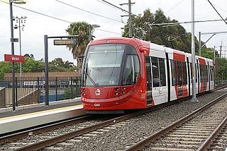
The Inner West Light Rail is a 12.8 km light rail line in Sydney, New South Wales, Australia, running from Central railway station through the Inner West to Dulwich Hill and serving 23 stops. It is the original line of the Sydney light rail network, and was originally known as Sydney Light Rail. Light rail services on the line are now branded as the L1 Dulwich Hill Line.

The Goods Line

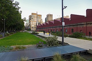
The Goods Line is an 800 m-long (2,625 ft) linear park and shared pedestrian pathway and cycleway in the suburb of Ultimo, in the City of Sydney, New South Wales, Australia. The corridor connects Railway Square to Darling Harbour in the south and passes both the University of Technology Sydney Broadway campus and the Australian Broadcasting Corporation Sydney head office. The Goods Line terminates in the north at the corner of Sussex and Hay Streets, in the Sydney central business district.

Ultimo Road railway underbridge

The Ultimo Road railway underbridge is a heritage-listed former railway bridge located on the former Darling Harbour goods railway line in the inner city Sydney suburb of Ultimo in the City of Sydney local government area of New South Wales, Australia. It was designed by engineering staff in the Existing Lines branch of the New South Wales Public Works Department and built in 1879. The property is owned by RailCorp, an agency of the Government of New South Wales. It was added to the New South Wales State Heritage Register on 2 April 1999.

Glebe and Wentworth Park railway viaducts

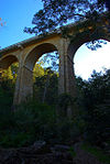
The Glebe and Wentworth Park railway viaducts are a series of two adjacent heritage-listed railway bridges and arch viaducts that carry the Inner West Light Rail across Wentworth Park, Jubilee Park, and Johnstons Creek in the inner western Sydney suburb of Glebe in the City of Sydney local government area of New South Wales, Australia. They were designed by the New South Wales Government Railways and built from 1892 to 1922 by day labour. They are also known as Wentworth Park Viaduct, Jubilee Park Viaduct and Glebe Viaducts. The viaducts were added to the New South Wales State Heritage Register on 2 April 1999.

Rozelle Yard

Rozelle Yard was a goods railway yard in Rozelle, New South Wales, Australia. Since heavy rail traffic ceased, part of the site has been redeveloped into a light rail depot and maintenance facility. Much of the former yard is currently being redeveloped as part of the Bays Precinct project.

Darling Harbour Yard

Darling Harbour Yard was a goods railway yard in Darling Harbour, New South Wales, Australia. The yard was once the origin of all outgoing goods traffic from Sydney. After closing to heavy rail in 1993, the alignment of the Metropolitan Goods line which passed through it was reutilised by light rail. The precinct around the yard has been significantly redeveloped since the closure.

References

  1. 1 2 "Railway Square road overbridge". New South Wales State Heritage Register . Office of Environment and Heritage. H01232. Retrieved 13 October 2018.
  2. 1 2 3 4 5 6 7 8 9 10 11 12 "Ultimo (Railway Square) Railway Overbridge". New South Wales Heritage Database. Office of Environment and Heritage . Retrieved 18 December 2018.

Attribution