Aldeburgh is a coastal town in the county of Suffolk, England, north of the River Alde. Its estimated population was 2,276 in 2019. It was home to the composer Benjamin Britten and remains the centre of the international Aldeburgh Festival of arts at nearby Snape Maltings, which was founded by Britten in 1948. It also hosts an annual poetry festival and several food festivals and other events.

The Suffolk & Essex Coast & Heaths National Landscape is an Area of Outstanding Natural Beauty in Suffolk and Essex, England.

Suffolk Wildlife Trust (SWT) describes itself as the county's "nature charity – the only organisation dedicated wholly to safeguarding Suffolk's wildlife and countryside." It is a registered charity, and its headquarters is at Brooke House in Ashbocking, near Ipswich. It was founded in 1961, and is one of 46 wildlife trusts covering the Great Britain and Northern Ireland. As of March 2017, it has 13,200 members, and it manages 3,120 hectares of land in 60 nature reserves, most of which are open to the public. It had an income of £3.9 million in the year to 31 March 2017.
Orford Ness is a cuspate foreland shingle spit on the Suffolk coast in Great Britain, linked to the mainland at Aldeburgh and stretching along the coast to Orford and down to North Weir Point, opposite Shingle Street. It is divided from the mainland by the River Alde, and was formed by longshore drift along the coast. The material of the spit comes from places further north, such as Dunwich. Near the middle point of its length, at the foreland point or 'Ness', once stood Orfordness Lighthouse, demolished in summer 2020 owing to the encroaching sea. In the name of the lighthouse, 'Orfordness' is written as one word.

Aldringham cum Thorpe is a civil parish in the East Suffolk district of Suffolk, England. Located south of the town of Leiston, the parish includes the villages of Aldringham and Thorpeness, which is on the coast, between Sizewell (north) and Aldeburgh (south). In 2007 it had an estimated population of 700, rising to 759 at the 2011 Census.

Boyton is a village and civil parish in the East Suffolk district of Suffolk, England, about eight miles east of Woodbridge, and close to Orford Ness. Boyton is a small village in South East England and is part of the heritage coast. In the Domesday Book of 1086 Boyton was recorded under the name "Bohtuna". The village has a number of facilities within the surrounding area, for instance Hollesley primary school, a village primary school for children aged 4–11 years. Boyton village hall is becoming a focus for new village activities, and HM Prison Hollesley Bay is also located not far from the village centre. In the 1870s Boyton was described by John Marius Wilson as:

Iken is a small village and civil parish in the sandlands of the English county of Suffolk, an area formerly of heathland and sheep pasture. It is near the estuary of the River Alde on the North Sea coast and is located south east of Snape and due north of Orford. To its west is Tunstall Forest, created since the 1920s by the Forestry Commission and now part of the Sandlings Forest.

The River Deben is a river in Suffolk rising to the west of Debenham, though a second, higher source runs south from the parish of Bedingfield. The river passes through Woodbridge, turning into a tidal estuary before entering the North Sea at Felixstowe Ferry. The mouth of the estuary is crossed by a ferry connecting Felixstowe and Bawdsey.

Havergate Island is the only island in the county of Suffolk, England. It is found at the confluence of the River Ore and the Butley River near the village of Orford. It is a marshy nature reserve run by the Royal Society for the Protection of Birds (RSPB) and is known for its population of pied avocets and terns. It is part of the ecologically important Alde-Ore Estuary and has protected conservation status as part of a national nature reserve, SSSI, SAC, SPA, Ramsar Site and is also a part of the Suffolk Coast and Heaths AONB.

The Butley River or Butley Creek is a tributary of the River Ore in the English county of Suffolk. The river has its source in the Rendlesham Forest area to the east of Eyke.
Plomesgate is a hundred of Suffolk, consisting of 41,579 acres (168.26 km2).

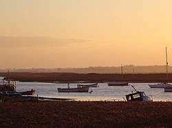
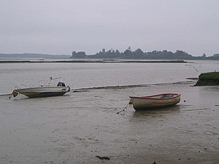
Alde–Ore Estuary is a 2,534 hectare biological and geological Site of Special Scientific Interest which stretches along the Suffolk coast between Aldeburgh and Bawdsey, and also includes parts of the Alde, Ore and Butley Rivers. It is in the Suffolk Coast and Heaths Area of Outstanding Natural Beauty, and is a Grade I Nature Conservation Review site, a Special Area of Conservation, a Ramsar internationally important wetland site, and a Special Protection Area under the European Union Directive on the Conservation of Wild Birds. It includes two Geological Conservation Review sites, "Orfordness and Shingle Street" and "The Cliff, Gedgrave", and two nature reserves managed by the Suffolk Wildlife Trust, Alde Mudflats and Simpson's Saltings. The coastal part of the site is Orfordness-Havergate, a National Nature Reserve, and Orford Ness is managed by the National Trust, while Havergate Island is managed by the Royal Society for the Protection of Birds.

Capel St Andrew is a village and a civil parish in the East Suffolk district, in the county of Suffolk, England. It is near the larger settlement of Orford.
Alde Mudflats is a 22 hectare nature reserve west of Iken in Suffolk. It is owned by the Crown Estate and managed by the Suffolk Wildlife Trust. It is in the Suffolk Coast and Heaths Area of Outstanding Natural Beauty, and part of the Alde-Ore Estuary Site of Special Scientific Interest, Ramsar internationally important wetland site, Special Area of Conservation, Special Protection Area under the European Union Directive on the Conservation of Wild Birds, and Grade I Nature Conservation Review site,

Simpson's Saltings is a 25 hectare nature reserve on the Suffolk coast east of Hollesley. It is managed by the Suffolk Wildlife Trust. It is in the Suffolk Coast and Heaths Area of Outstanding Natural Beauty, and part of the Alde-Ore Estuary Site of Special Scientific Interest, Ramsar internationally important wetland site, Special Area of Conservation, Special Protection Area under the European Union Directive on the Conservation of Wild Birds, and Grade I Nature Conservation Review site,

Hazlewood Marshes is a 64 hectare nature reserve west of Aldeburgh in Suffolk. It is managed by the Suffolk Wildlife Trust. It is in the Alde-Ore Estuary biological Site of Special Scientific Interest.

Leiston - Aldeburgh is a 534.8-hectare (1,322-acre) biological Site of Special Scientific Interest which stretches from Aldeburgh to Leiston in Suffolk. Part of it is The Haven, Aldeburgh Local Nature Reserve, and another area is the North Warren RSPB nature reserve. There is also a prehistoric bowl barrow on Aldringham Common, which is a Scheduled Monument. The site is in the Sandlings Special Protection Area under the European Union Directive on the Conservation of Wild Birds, and the Suffolk Coast and Heaths Area of Outstanding Natural Beauty.