
Suffolk is a ceremonial county in the East of England and East Anglia. It is bordered by Norfolk to the north, the North Sea to the east, Essex to the south, and Cambridgeshire to the west. Ipswich is the largest settlement and the county town.

Aldeburgh is a coastal town in the county of Suffolk, England, north of the River Alde. Its estimated population was 2,276 in 2019. It was home to the composer Benjamin Britten and remains the centre of the international Aldeburgh Festival of arts at nearby Snape Maltings, which was founded by Britten in 1948. It also hosts an annual poetry festival and several food festivals and other events.

The Aldeburgh Festival of Music and the Arts is an English arts festival devoted mainly to classical music. It takes place each June in the Aldeburgh area of Suffolk, centred on Snape Maltings Concert Hall.
Leiston is an town in the East Suffolk district of Suffolk, England. It is close to Saxmundham and Aldeburgh, 21 miles (34 km) north-east of Ipswich and 90 miles (145 km) north-east of London. The town had a population of 5,508 at the 2011 Census.

Framlingham is a market town and civil parish in Suffolk, England. Of Anglo-Saxon origin, it appears in the 1086 Domesday Book. The parish had a population of 3,342 at the 2011 census and an estimated 4,016 in 2019. Nearby villages include Earl Soham, Kettleburgh, Parham, Saxtead and Sweffling.

Prittlewell is an inner city area and former civil parish in Southend-on-Sea, in the ceremonial county of Essex, England. Historically, Prittlewell is the original settlement of the city, Southend being the south end of Prittlewell. The village of Prittlewell was originally centered at the joining of three main roads, East Street, West Street, and North Street, which was extended south in the 19th century and renamed Victoria Avenue. The principal administrative buildings in Southend are located along Victoria Avenue, although Prittlewell is served by Prittlewell railway station.
Snape Maltings Concert Hall is an arts complex on the banks of the River Alde at Snape, Suffolk, England. It is best known as one of the main sites of the annual Aldeburgh Festival. It is now one of two headquarters for Britten Pears Arts, with the other being The Red House.

The River Alde and River Ore form a river system in Suffolk, England passing by Snape and Aldeburgh. The River Alde and River Ore meet northwest of Blaxhall. From there downriver the combined river is known as the River Alde past Snape and Aldeburgh, and then again as the River Ore as it approaches Orford and flows by a shingle spit before emptying into the North Sea.

Aldringham cum Thorpe is a civil parish in the East Suffolk district of Suffolk, England. Located south of the town of Leiston, the parish includes the villages of Aldringham and Thorpeness, which is on the coast, between Sizewell (north) and Aldeburgh (south). In 2007 it had an estimated population of 700, rising to 759 at the 2011 Census.
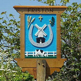
Friston is a village and civil parish in the East Suffolk district, in the county of Suffolk, England. It is 3 miles (5 km) southeast of Saxmundham, its post town, and 4 miles (6 km) northwest of Aldeburgh. The River Alde bounds the village on the south. The surrounding land is chiefly arable. The soil becomes partly marshy in the lower grounds. The village is noted for its early nineteenth century post mill. It is located next to the village of Knodishall.

Iken is a small village and civil parish in the sandlands of the English county of Suffolk, an area formerly of heathland and sheep pasture. It is near the estuary of the River Alde on the North Sea coast and is located south east of Snape and due north of Orford. To its west is Tunstall Forest, created since the 1920s by the Forestry Commission and now part of the Sandlings Forest.

The Snape Anglo-Saxon Cemetery is a place of burial dated to the 6th century AD located on Snape Common, near to the town of Aldeburgh in Suffolk, Eastern England. Dating to the early part of the Anglo-Saxon Era of English history, it contains a variety of different forms of burial, with inhumation and cremation burials being found in roughly equal proportions. The site is also known for the inclusion of a high status ship burial. A number of these burials were included within burial mounds.

Dommoc, a place not certainly identified but probably within the modern county of Suffolk, was the original seat of the Anglo-Saxon bishops of the Kingdom of East Anglia. It was established by Sigeberht of East Anglia for Saint Felix in c. 629–631. It remained the bishopric of all East Anglia until c. 673, when Theodore of Tarsus, Archbishop of Canterbury, divided the see and created a second bishopric at either North Elmham, Norfolk, or South Elmham, Suffolk. The see of Dommoc continued to exist until the time of the Viking Wars of the 860s, after which it lapsed.

Newson Garrett was a maltster, instrumental in the revival of the town of Aldeburgh, Suffolk, of which he became mayor at the end of his life. Two of his daughters, Millicent and Elizabeth, became famous as women's rights activists, and his granddaughter Philippa was the first woman to rank highest in the Mathematical Tripos examinations.

Great Glemham is a village and civil parish in the East Suffolk district, England, a mile and a half to the west of the A12 and roughly equidistant between Framlingham and Saxmundham.
The archaeology of Anglo-Saxon England is the study of the archaeology of England from the 5th century AD to the 11th century, when it was ruled by Germanic tribes known collectively as the Anglo-Saxons.
Sutton is a village and a civil parish on the B1083 road, in the East Suffolk district, in the county of Suffolk, England. Sutton has a pub, a mobile post office and a place of worship. There is also the hamlet of Sutton Street and the Sutton Common estate nearby.

The Snape branch line was a railway branch line located in Suffolk which served Snape Maltings. It ran from Snape Junction on the East Suffolk line and was 1¼ miles long. The line was opened in 1859 and throughout its life was operated as a freight-only line. The line was closed 101 years later in 1960.
Britten Pears Arts is a large music education organisation based in Suffolk, England. It aims to continue the legacy of composer Benjamin Britten and his partner, singer Peter Pears, and to promote the enjoyment and experience of music for all. It is a registered charity.

The A1094 is an A road in the English county of Suffolk. It is around 7 miles (11 km) in length. The road runs from a junction off the A12 trunk road at Friday Street in Benhall to Aldeburgh on the North Sea coast. The road is single carriageway throughout.


