Clopton, Suffolk

Last updated

Clopton
St. Mary, Clopton - geograph.org.uk - 119739.jpg
Tower of St Mary's Church, Clopton
Suffolk UK location map.svg
Red pog.svg
Clopton
Location within Suffolk
Population375 (2011 Census)
Civil parish
  • Clopton
District
Shire county
Region
Country England
Sovereign state United Kingdom
Post town Woodbridge
Postcode district IP13
UK Parliament
List of places
UK
England
Suffolk
52°07′01″N1°15′00″E / 52.117°N 1.25°E / 52.117; 1.25 Coordinates: 52°07′01″N1°15′00″E / 52.117°N 1.25°E / 52.117; 1.25
Historical map showing Clopton and surrounding areas. 19th century Ordnance Survey map of Clopton, Suffolk..PNG
Historical map showing Clopton and surrounding areas.
Chart of recorded occupations in Clopton in 1881. The outer ring represents men and the inner women. Clop1881Occupation.png
Chart of recorded occupations in Clopton in 1881. The outer ring represents men and the inner women.
Graph of Clopton's population from 1801 to 2011, from available census records. ClopPop.png
Graph of Clopton's population from 1801 to 2011, from available census records.
Chart of Clopton's population structure, using data from the 2011 Census. Clopton Population Structure.png
Chart of Clopton's population structure, using data from the 2011 Census.

Clopton is a village and civil parish in Suffolk. It is located between Ipswich and Debenham two kilometres north of Grundisburgh on the River Lark. The village is no larger than a series of houses either side of the B1078, surrounded by farm land. The village itself has no clear centre; houses and other buildings are concentrated around the four manors of Kingshall, Brendhall, Rousehall and Wascolies, all of which are mentioned in the Domesday Book of 1086. [1] [2]

Contents

As of 2011, the population of the parish numbered 375 people. [3] The village previously had a school, which was built in 1875 and had capacity for 100 pupils with an average attendance of 56, [4] however it closed in the late 1930s. [1] Pupils instead attend schools in Grundisburgh or Woodbridge, with a bus service provided by Suffolk County Council. [5]

History

Historical Writings

The earliest known mention of Clopton is a record in the Domesday Book as "Clopetuna". [6]

In the early 1870s, it was described in John Marius Wilson's Imperial Gazetteer of England and Wales as:

"...a parish in Woodbridge district, Suffolk; 3½ miles N by W of Bealings r. station, and 4 NW of Woodbridge. Post town, Grundisburgh, under Wood-bridge. Acres, 2, 074. Real property, £4, 012. Pop., 407. Houses, 84. The property is divided among a few. Part of the land is common. The living is a rectory in the diocese of Norwich. Value, £720.* Patron, Mrs. E. Taylor. The church is old but good; and there are charities £34." [7]

In 1887, John Bartholomew also wrote an entry on Clopton in the Gazetteer of the British Isles with a much shorter description:

"Clopton, par., E. Suffolk, 4 miles NW. of Woodbridge, 2074 ac., pop. 382; P.O.; contains C. Hall." [8]

The BBC Domesday Project described Clopton in a similar yet more detailed fashion to the Gazetteer entries in 1986:

"Clopton is a small village situated approximately 7 miles from Ipswich and 4 miles from Woodbridge in the county of Suffolk. The area consists mainly of arable farms together with a small amount of housing. To the east side of Clopton is an area of disused airfield which now has a small amount of light industry. To the west side is the East Suffolk College of Agriculture and Horticulture at Otley; again consisting mainly of farmland. The village is served by a Post Office, bus service, mobile tradesmen and has 3 churches. There are no schools or shops in Clopton." [9]

World War II

Between Clopton and the nearby village of Debach, the site of RAF Debach can be found, which was home to the USAAF 493d Bombardment Group over the course of World War II. [10] A service memorial and the flag flown over the base can be found inside St. Mary's church at Clopton. [11]

Industry

In 1831, the decennial census found that over three-quarters of Clopton's population worked in agriculture, with most of these being labourers employed by farmers. Other than this, the parish had a small number describing themselves as being employed in "retail and handicrafts," and an even smaller number being "professionals" or "other." [12]

In 1844, White's Directories for Suffolk listed 13 farmers, a shoemaker, blacksmith and wheelwright. [6] The 1912 edition listed 19 farmers, a farm bailiff, postmaster, schoolmaster, builder, shoemaker, wheelwright, storekeeper, grocer, hardware merchant, furniture remover/carrier, publican and insurance agent. [6]

By 1881, the Parish as a whole, while still mostly reliant on agriculture to provide work, had diversified into other industries. Around this time, the presence of women in the workplace had increased somewhat as well: though these industries were small in comparison to the almost entirely male-dominated agricultural sector, in the 1881 census women outnumbered men in the 'Domestic Services and Offices' and 'Dress' occupation orders. Nonetheless, while 75 men reported working in agriculture, only 9 women reported having an occupation at all. [13]

Population

Since the passing of the Census Act 1800, Clopton's overall population has remained relatively unchanged. In 1801, the first decennial census recorded a population of 389 people, while an all-time high of 468 was recorded in 1831. [14]

The Modern Parish

The modern village of Clopton has been described as:

"...a widely spaced village which consists mainly of farming, around 140 residential homes and a few small businesses. There is a very good village hall at the centre of the village, which gets plenty of bookings... but, unfortunately, no village pub, nor shop. However, there are several of each in the nearby surrounding villages." [15]

Demographics

In 2011, the National Census found that 385 people lived in Clopton, and of these 186 were male and 189 female. [3] The average age of people in Clopton is 41 years, though the largest age group is 45–59 years, with 83 people (22.1% of the total population) reported. [16]

Employment

People in Clopton reported in the 2011 Census that they were primarily in full-time employment or self-employed (28.8% and 22.9% of the population, respectively), with a smaller percentage being in part-time employment (15.5%). [3] Men make up more of these figures than women: While 35.7% and 32.9% of men are in full-time employment and self-employed respectively, these figures are only 21.4% and 12.2% for women. [17] [18]

The principle sectors of employment for men, as found by the 2011 Census, are in "Skilled Trades Occupations" (25%), "Managers, Directors and Senior Officials" (23.1%) and "Professional Occupations" (21.3%). [19] For women, the main sectors are "Professional Occupations" (20%), "Managers, Directors and Senior Officials" (17.6%) and "Administrative and Secretarial Occupations" (17.6%), with an additional notable presence in "Caring, Leisure and Other Service Occupations" (14.1%). [20]

Local Politics

Clopton has joined a campaign dubbed "Save Our Rural Roads", first started in 1997 by Grundisburgh & Culpho Parish Council, after concerns of heavy goods vehicles causing damage to buildings and roads in the community. [21]

Residents of the village receive a quarterly news magazine from Grundisburgh and District News. [15]

Related Research Articles

Cratfield Human settlement in England

Cratfield is a village in northern Suffolk, England. "It has a population of 292 according to the 2011 census." Neighbouring villages include Laxfield, Metfield, Cookley, Huntingfield, Heveningham. The nearest town, Halesworth, is approximately 6.7 miles (10.7 km) away. Southwold is a popular, nearby coastal town. The market town of Framlingham is also close by.

Acton Turville Human settlement in England

Acton Turville is a parish in the Cotswold Edge ward within South Gloucestershire, England. It lies 17 miles (27 km) east-northeast of Bristol and 93 miles (150 km) due west of London, with the M4 south of the parish. Acton Turville consists of a cluster of households across 1,009 acres, with a total population of 370 people. Acton Turville is also listed as "Achetone" in the Domesday Book.

Badingham Human settlement in England

Badingham is a civil parish in the East Suffolk district of eastern England, in the county of Suffolk. It is situated 21.8 miles north east of Ipswich, 35 miles away from Norwich and 13 miles away from the coast. With the road "A1120" slicing through the middle of the parish. Badingham's name is Anglo-Saxon and means "the farmstead of Beada's people". Badingham contains a significant number of farms, sparse amount of housing, numerous B&Bs as well as St. John's Church.

Stanton under Bardon Human settlement in England

Stanton-under-Bardon is a village and civil parish about 4 miles (6.4 km) southeast of Coalville, Leicestershire, England. The 2011 Census recorded the parish's population as 634.

Farnham, Suffolk Human settlement in England

Farnham is a village and civil parish about 3 miles (4.8 km) south-west of Saxmundham in the English county of Suffolk on the A12 road. Farnham is located west of Friday Street, south of Benhall Low Street and north-east of Stratford St Andrew.

Lowesby is a small parish and township situated in the district of Harborough in Leicestershire county. It is 8 miles east of the county capital, Leicester, and 90 miles north of London.

Winston, Suffolk Human settlement in England

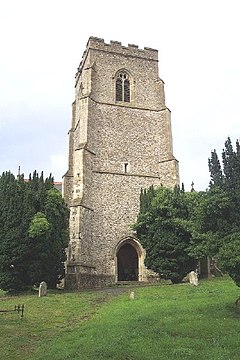
Winston is a village and civil parish in the Mid Suffolk district of Suffolk in eastern England. Located around 8 miles (13 km) east of Stowmarket, the 2011 Census showed that the population of the parish of Winston is 159. The parish also contains the settlements of Winston Green and Fenn Street. There is a church and an old school room, and every year there is a Winston Village Fete. A lot of the village of Winston is based around 14th Century Church, with multiple 16th Century cottages and farmhouses along church lane, showing the villages agricultural past, the area of Winston is still agricultural based with farms and fields all over the parish. Winston and the surrounding area is approximately 45m-50m above sea level making the area unlikely to flood, unless in exceptional circumstances. In the 1870s Winston was described as:

Winston, a parish, with a village, in Bosmere district, Suffolk; 1 mile SSE of Debenham, and 7 NE of Needham r. station.

Fakenham Magna Human settlement in England

Fakenham Magna is a village and civil parish in the West Suffolk district of Suffolk in eastern England. The meaning of the word 'Fakenham' can be split into two: 'Faken' and 'ham', both of which derive from Old English. The former refers to somebody by the name of 'Facca', with the latter meaning 'a village / a homestead', making the direct translation 'Facca's homestead'. 'Magna' translates from Latin as 'great', hence the alternative name of the village of 'Great Fakenham'. During World War Two, however, the village was referred to as 'Little Fakenham', which was used to avoid confusion with the larger civil parish of Fakenham in Norfolk.

Great Livermere Human settlement in England

Great Livermere is a village and civil parish in the West Suffolk district of Suffolk in eastern England. It is located around four miles north-east of the borough's largest town Bury St Edmunds.

Stansfield Human settlement in England

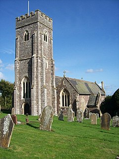
Stansfield is a village and civil parish in the West Suffolk district of Suffolk in eastern England. Located seven miles south-west of Bury St Edmunds, in 2011 its population was 221. The village has an Anglican church dedicated to All Saints. In 1870, John Marius Wilson's Imperial Gazetteer of England and Wales described Stansfield as

Ousden Human settlement in England

Ousden is a village and civil parish in the West Suffolk district of Suffolk in eastern England. It is located around six miles west of Bury St Edmunds and 72 miles north of London, and as of 2011, its population is 266. The village has an Anglican church of St Peter's and a chapel in the cemetery dedicated to St Barnabas.

Kirton, Suffolk Human settlement in England

Kirton is a village and a civil parish in the shire county of Suffolk, England, situated off the A14 road, about 4.5 km (2.8 mi) from Felixstowe and around 10 km (6.2 mi) from Ipswich. The closest train station to Kirton is Trimley. According to the 2011 census, Kirton had a population of 1,146. It is located between the River Deben and the River Orwell. The village of Kirton covers a total area of 8.3 km2 (3.2 sq mi). As the county of Suffolk lacks quarries, many of the buildings are made from flint, clay and timber.

Walpole, Suffolk Human settlement in England

Walpole is a small village and civil parish in the district of East Suffolk in Suffolk, England. Walpole has a parish church, a redundant chapel, but the primary school has closed. The village is on the River Blyth. Nearby settlements include the town of Halesworth and the village of Cookley. It was in the hundred of Blything. It had a population of 238 according to the 2011 census.

Pettistree Human settlement in England

Pettistree is a small village and a civil parish in the East Suffolk district, in the English county of Suffolk. According to the 2011 Census, Pettistree had a population of 194 people and is set in around 1,800 acres of farmland. The village has many footpaths and country lanes surrounding it. Being only one mile from the larger village of Wickham Market, Pettistree uses many of their resources; such as the Post Office, Medical and Resource Centre and Children's Play Area. The Primary School situated in Wickham Market also serves the younger children of Pettistree. However, senior children are required to travel 7 miles to Thomas Mills High School which is situated in Framlingham.

Eyke Human settlement in England

Eyke is a village and a civil parish in the East Suffolk district, in the English county of Suffolk. It is located on the A1152 road near the town of Woodbridge. Eyke has a primary school, the manor house of Lord and Lady Lucas with scenic pond and horse paddock, and a pub. The mediaeval parish church of All Saints was restored in the 1860s. Services are normally held on the first and third Sundays of the month.

Sutton is a village and a civil parish on the B1083 road, in the East Suffolk district, in the county of Suffolk, England. Sutton has a pub, a mobile post office and a place of worship. There is also the hamlet of Sutton Street and the Sutton Common estate nearby.

Huntingfield, Suffolk Human settlement in England

Huntingfield is a village near the B1117 road, in the East Suffolk district, in the county of Suffolk, England. The village is close to the source of the River Blyth and the parish is 12 miles from the seaside town of Southwold. Nearby settlements include the town of Halesworth and the villages of Walpole, Heveningham, Cookley and Laxfield.

Standon, Staffordshire Human settlement in England

Standon is a village and civil parish in the Stafford district, in the county of Staffordshire, England. Standon has a church called Church of All Saints and one school called All Saints C of E First School. In 2001 the population of the civil parish of Standon was 823, and in the 2011 census it had a population of 879.

Shobrooke Village in Devon, England

Shobrooke is a village, parish and former manor in Devon, England. The village is situated about 1 1/2 miles north-east of Crediton. It is located close to Shobrooke park. The river Shobrooke Lake flows through the village. It had a population of 537 according to the 2011 census. The name Shobrooke is derived from the old English words of succa and brōc, and translates as goblin brook.

Woodbridge Rural District

Woodbridge Rural District was a rural district within the administrative county of East Suffolk between 1894 and 1934. It was created out of the earlier Woodbridge rural sanitary district. It surrounded the town of Woodbridge, which had earlier been created as an urban district.

References

  1. 1 2 "Clopton Church – Village History". Church of St. Mary the Virgin, Clopton. Retrieved 3 March 2015.
  2. "Manorial court books for Kingshall, Brendhall, Wascolies, and Rousehall in the parish of Clopton, Suffolk (England), 1600–1866". ArchiveGrid. Retrieved 24 April 2015.
  3. 1 2 3 "Clopton (Parish): Key Figures for 2011 Census: Key Statistics". Neighbourhood Statistics. Office for National Statistics. Retrieved 27 January 2015.
  4. "Clopton Church – Clopton School". Church of St. Mary the Virgin, Clopton. Retrieved 3 March 2015.
  5. "BBC – Domesday Reloaded: Schooling at Clopton". BBC – Domesday Reloaded. Archived from the original on 25 September 2015. Retrieved 3 March 2015.
  6. 1 2 3 "History of Clopton, Suffolk". Clopton, Suffolk. Retrieved 21 February 2015.
  7. Wilson, John Marius (1870–1872). Imperial Gazetteer of England and Wales. Edinburgh: A. Fullerton & Co. Retrieved 27 January 2015.
  8. Bartholomew, John (1887). "Gazetteer of the British Isles". Edinburgh: A. and C. Black. Retrieved 20 April 2015.
  9. "CLOPTON VILLAGE". domesday. Archived from the original on 22 March 2012. Retrieved 18 July 2019.
  10. "Debach Airfield History". Helton's Hellcats, 493d BG(H) Debach. Bomb Group Museum Debach. Retrieved 28 March 2015.
  11. "St. Mary, Clopton". Suffolk Churches. Retrieved 28 March 2015.
  12. GB Historical GIS / University of Portsmouth. "Industry Statistics: Male aged 20 & over, in 9 occupational categories". Vision of Britain. Retrieved 11 February 2015.
  13. GB Historical GIS / University of Portsmouth. "Industry Statistics: Occupation data classified into the 24 1881 'Orders', plus sex". Vision of Britain. Retrieved 14 April 2015.
  14. GB Historical GIS / University of Portsmouth. "Population Statistics: Total Population". Vision of Britain. Retrieved 11 February 2015.
  15. 1 2 "Information about the village of Clopton, Suffolk, UK". OneSuffolk. Retrieved 24 April 2015.
  16. "Clopton (Parish): Key Figures for 2011 Census: Age Structure". Neighbourhood Statistics. Office for National Statistics. Retrieved 25 March 2015.
  17. "Clopton (Parish): Key Figures for 2011 Census: Economic Activity – Males". Neighbourhood Statistics. Office for National Statistics. Retrieved 20 April 2015.
  18. "Clopton (Parish): Key Figures of 2011 Census: Economic Activity – Females". Neighbourhood Statistics. Office for National Statistics. Retrieved 20 April 2015.
  19. "Clopton (Parish): Ket Figures for 2011 Census: Occupation – Males". Neighbourhood Statistics. Office for National Statistics. Retrieved 20 April 2015.
  20. "Clopton (Parish): Key Figures for 2011 Census: Occupations – Females". Neighbourhood Statistics. Office for National Statistics. Retrieved 20 April 2015.
  21. "Campaign to Save Our Rural Roads". SORR – Save Our Rural Roads. Retrieved 20 April 2015.

Commons-logo.svg Media related to Clopton, Suffolk at Wikimedia Commons