Thorpeness

Last updated

Thorpeness
The House on Stilts - geograph.org.uk - 1467632.jpg
Thorpeness Meare
Suffolk UK location map.svg
Red pog.svg
Thorpeness
Location within Suffolk
Shire county
Region
Country England
Sovereign state United Kingdom
Post town Leiston
Postcode district IP16
List of places
UK
England
Suffolk
52°10′46″N1°36′53″E / 52.179333°N 1.614710°E / 52.179333; 1.614710

Thorpeness is a seaside village in the East Suffolk district of Suffolk, England, which developed in the early 20th century into an exclusive holiday village. It belongs to the parish of Aldringham cum Thorpe and lies within the Suffolk Coast and Heaths AONB.

Contents

Development

For the earlier history of Thorpe, see Aldringham-cum-Thorpe.

The village was a small fishing hamlet originating in the late 19th century, with folk tales of it being a route for smugglers into East Anglia. The landowning Ogilvie family, began to buy into the area in 1859. [1] In 1910, Glencairn Stuart Ogilvie, a Scottish barrister whose father had made a fortune building railways around the world, increased the family's local estates to cover the entire area from north of Aldeburgh to past Sizewell, up the coast and inland to Aldringham and Leiston. [2]

Most of this land was used for farming, but Ogilvie developed Thorpeness into an elite private fantasy holiday village, to which he invited his friends' and colleagues' families during the summer months. An exclusive country club with tennis courts, a swimming pool, clubhouse; a golf club designed by the eminent James Braid with its own club house; and many holiday homes were built in Jacobean and Tudor Revival styles. [3] Thorpeness railway station, provided by the Great Eastern Railway to serve what was expected to be an expanding resort, was opened a few days before the outbreak of World War I. It was little used, except by golfers, and closed in 1966. [4]

A notable feature of the village is a set of almshouses built in the 1920s to the design of W. G. Wilson. [5] To hide the eyesore of having a water tower in the village, the tank built in 1923 was clad in wood to make it look like a small house on top of a five-storey tower, with a separate mill next to it, which pumped water to it. It is known as the "House in the Clouds", and after mains water was installed in the village, the old tank was transformed into a huge games room with views over the land from Aldeburgh to Sizewell. [6]

For three generations Thorpeness remained mostly in the private ownership of the Ogilvie family, with houses only being sold from the estate to friends as holiday homes. In 1972, Alexander Stuart Ogilvie, Glencairn Stuart Ogilvie's grandson, died on the Thorpeness Golf Course. Many of the houses and the golf course and country club had to be sold to pay death duties. [7]

The Meare

An artificial boating lake known as the Meare was created where there had once been an Elizabethan shipping haven that had silted up. [8] Many of the inspirations for the Meare came from a personal friend of the Ogilvies, J. M. Barrie, who wrote Peter Pan . [7] Along with a large main pond, there are several channels with landings marked with names from the Peter Pan stories. Tiny islands on the Meare contain locations found in the novel, such as the pirates' lair, Wendy's house, and many others, where children are encouraged to play. The Meare was dug to a shallow depth for safety reasons. [8]

A variety of boats can be rented to enjoy the water, many of them originals dating from the creation of the Meare and named by the local workmen who had dug the lake. In August, the Meare serves as the location for the Thorpeness Regatta, which has been held since 1913. [9]

Thorpeness today

The House in the Clouds is an unusual house, converted from a water tower in 1923. The House in the Clouds, Thorpeness.jpg
The House in the Clouds is an unusual house, converted from a water tower in 1923.

To the south of the village lies the North Warren RSPB reserve, an area of wildlife and habitat conservation and nature trails run by the Royal Society for the Protection of Birds. It has Site of Special Scientific Interest (SSSI) and Special Protection Area (SPA) status. [10]

Like much of the East Coast, Thorpeness has had intermittent problems with erosion. Discussions are still underway for further defences. [11] [12]

A lifeboat crew from Thorpeness rescues Tim and his friend the sea captain in the Edward Ardizzone book Little Tim and the Brave Sea Captain (1936). [13]

The Second World War

Related Research Articles

<span class="mw-page-title-main">Aldeburgh</span> Coastal town in Suffolk

Aldeburgh is a coastal town in the county of Suffolk, England, north of the River Alde. Its estimated population was 2,276 in 2019. It was home to the composer Benjamin Britten and remains the centre of the international Aldeburgh Festival of arts at nearby Snape Maltings, which was founded by Britten in 1948. It also hosts an annual poetry festival and several food festivals and other events.

<span class="mw-page-title-main">Suffolk Coast and Heaths</span> Area of Outstanding Natural Beauty in England

The Suffolk Coast and Heaths AONB is an Area of Outstanding Natural Beauty in Suffolk and Essex, England.

Leiston is an English town in the East Suffolk non-metropolitan district of Suffolk, near Saxmundham and Aldeburgh, about 2 miles (3 km) from the North Sea coast, 21 miles (34 km) north-east of Ipswich and 90 miles (145 km) north-east of London. The town had a population of 5,508 at the 2011 Census.

<span class="mw-page-title-main">RSPB Minsmere</span> Nature reserve in the United Kingdom

RSPB Minsmere is a nature reserve owned and managed by the Royal Society for the Protection of Birds (RSPB) at Minsmere, Suffolk. The 1,000-hectare (2,500-acre) site has been managed by the RSPB since 1947 and covers areas of reed bed, lowland heath, acid grassland, wet grassland, woodland and shingle vegetation. It lies within the Suffolk Coast and Heaths Area of Outstanding Natural Beauty and the Suffolk Heritage Coast area. It is conserved as a Site of Special Scientific Interest, Special Area of Conservation, Special Protection Area and Ramsar site.

<span class="mw-page-title-main">Sizewell</span> English fishing village and nuclear reactor site

Sizewell is an English fishing hamlet in the East Suffolk district of Suffolk, England. It belongs to the civil parish of Leiston and lies on the North Sea coast just north of the larger holiday village of Thorpeness, between the coastal towns of Aldeburgh and Southwold. It is 2 miles (3.2 km) east of the town of Leiston and belongs within the Suffolk Coast and Heaths AONB. It is the site of two nuclear power stations, one of them still active. There have been tentative plans for a third station to be built at the site.

<span class="mw-page-title-main">Minsmere</span>

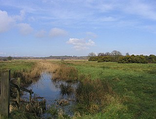
Minsmere is a place in the English county of Suffolk. It is located on the North Sea coast around 3.5 miles (5.6 km) north of Leiston and 1.5 miles (2.4 km) south-east of Westleton within the Suffolk Coast and Heaths AONB. It is the site of the Minsmere RSPB reserve and the original site of Leiston Abbey.

<span class="mw-page-title-main">Saxmundham railway station</span> Railway station in Suffolk, England

Saxmundham railway station is on the East Suffolk Line in the east of England, serving the town of Saxmundham, Suffolk. Situated between Wickham Market and Darsham, it is 22 miles 29 chains (36 km) down the line from Ipswich, and 91 miles 11 chains (147 km) from London Liverpool Street. Its three-letter station code is SAX.

<span class="mw-page-title-main">Aldringham cum Thorpe</span> Human settlement in England

Aldringham cum Thorpe is a civil parish in the East Suffolk district of Suffolk, England. Located south of the town of Leiston, the parish includes the villages of Aldringham and Thorpeness, which is on the coast, between Sizewell (north) and Aldeburgh (south). In 2007 it had an estimated population of 700, rising to 759 at the 2011 Census.

<span class="mw-page-title-main">Aldringham</span> Human settlement in England

Aldringham is a village in the Blything Hundred of Suffolk, England. The village is located 1 mile south of Leiston and 3 miles northwest of Aldeburgh close to the North Sea coast. The parish includes the coastal village of Thorpeness. The mid-2005 population estimate for Aldringham cum Thorpe parish was 730.

<span class="mw-page-title-main">Shotley</span> Human settlement in England

Shotley is a village and civil parish 8 miles (13 km) south-east of Ipswich in the English county of Suffolk. It is in the Babergh district and gives its name to the Shotley peninsula between the Rivers Stour and Orwell. The parish includes the village of Shotley and the settlements of Shotley Gate and Church End. In 2011 civil parish had a population of 2,342.

<span class="mw-page-title-main">Sizewell Hall</span> Christian centre in Suffolk, England

Sizewell Hall houses a Christian conference centre in Sizewell on the Suffolk coast, England. The estate is owned by the Ogilvie family. Back in the 1950s it housed a progressive school for 7–13s. It has historical connections with a classic taxidermy collection. The present Christian conference centre is run by Sizewell Hall Ltd, a registered charity. In 2007, 6,500 visitors stayed there, mainly local church groups from East Anglia, national bodies and a local youth organisation CYM from Ipswich. CYM has developed an activity holiday for schoolchildren in the African Village in the Hall grounds.

<span class="mw-page-title-main">Aldeburgh railway station</span> Former station in Suffolk, England

Aldeburgh railway station was a station in Aldeburgh, Suffolk. It was opened in 1860 by the East Suffolk Railway, and later came under the control of the Great Eastern Railway. The terminus of an 8.5 mile branch line to Saxmundham, the station closed in 1966 as part of the Beeching Axe as much of the British rural rail network was cut back.

<span class="mw-page-title-main">Aldeburgh branch line</span> Disused railway line in East Suffolk

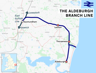
The Aldeburgh branch line was a railway branch line linking the town of Saxmundham on the East Suffolk line and the seaside resort of Aldeburgh. There were intermediate stops at Leiston and Thorpeness. Part of the line remains in use for nuclear flask trains servicing Sizewell nuclear power station.

<span class="mw-page-title-main">Thorpeness Windmill</span> Historic windmill in Suffolk, England

Thorpeness Windmill is a Grade II listed post mill at Thorpeness, Suffolk, England which was built in 1803 at Aldringham and moved to Thorpeness in 1923. Originally built as a corn mill, it was converted to a water pumping mill when it was moved to Thorpeness. It pumped water to the House in the Clouds.

<span class="mw-page-title-main">North Warren RSPB reserve</span>

North Warren RSPB reserve is a nature reserve run by the Royal Society for the Protection of Birds (RSPB) in Suffolk, England. It lies on the Suffolk coast on the north edge of the town of Aldeburgh and to the south of Thorpeness and includes the Aldringham Walks area of heathland to the north. It is within the Suffolk Coast and Heaths Area of Outstanding Natural Beauty (AONB) and the Suffolk Heritage Coast area. Noted for its populations of Eurasian bittern, European nightjar and other bird species, it covers a range of coastal habitats and is protected with SSSI, SPA conservation status.

<span class="mw-page-title-main">A1094 road</span> Road in Suffolk, England

The A1094 is an A road in the English county of Suffolk. It is around 7 miles (11 km) in length. The road runs from a junction off the A12 trunk road at Friday Street in Benhall to Aldeburgh on the North Sea coast. The road is single carriageway throughout.

<span class="mw-page-title-main">Aldeburgh Cottage Hospital</span> Hospital in England

The Aldeburgh Cottage Hospital is located at Park Road, Aldeburgh, Suffolk in England. Its 20 beds are currently run by Suffolk Community Healthcare, which in turn is run by Serco, an outsourcing company. The services of the hospital as a whole are delivered "on behalf of the NHS by Serco, East Suffolk and North Essex NHS Foundation Trust and Community Dental Services CIC."

<span class="mw-page-title-main">Leiston - Aldeburgh</span>

Leiston - Aldeburgh is a 534.8-hectare (1,322-acre) biological Site of Special Scientific Interest which stretches from Aldeburgh to Leiston in Suffolk. Part of it is The Haven, Aldeburgh Local Nature Reserve, and another area is the North Warren RSPB nature reserve. There is also a prehistoric bowl barrow on Aldringham Common, which is a Scheduled Monument. The site is in the Sandlings Special Protection Area under the European Union Directive on the Conservation of Wild Birds, and the Suffolk Coast and Heaths Area of Outstanding Natural Beauty.

<span class="mw-page-title-main">The Parrot and Punchbowl, Aldringham</span> Building in Suffolk, England

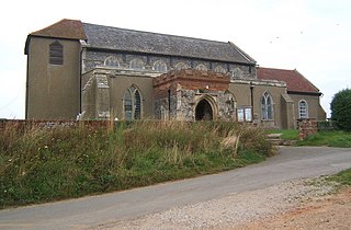
The Parrot and Punchbowl is a 16th-century English pub in the Suffolk village of Aldringham in the Aldringham-cum-thorpe parish. It is a grade II listed building associated with a history of smuggling. Its current title is The Parrot.

References

  1. "Sizewell Hall" . Retrieved 15 February 2018.
  2. "Suffolk: The man who dared to dream, and then created Thorpeness". East Anglian Daily Times. 25 May 2012. Retrieved 16 October 2023.
  3. "Thorpeness Golf Course" . Retrieved 16 October 2023.
  4. "Thorpeness Halt". Disused Stations. Subterranea Britannica. Retrieved 28 January 2016.
  5. Wilson's firm. Retrieved 15 November 2020.
  6. Owners' website Retrieved 15 February 2018.
  7. 1 2 Haines, Gavin (7 December 2022). "Is this Britain's most eccentric village? Inside Suffolk's Peter Pan-themed utopia" . The Daily Telegraph. Retrieved 7 December 2022.
  8. 1 2 Aldeburgh holiday site Retrieved 15 February 2015. Archived 5 March 2017 at the Wayback Machine
  9. "Nostalgia: Magical lit parade still a favourite a century on". East Anglian Daily Times. 13 November 2018. Retrieved 16 October 2023.
  10. "The RSPB: North Warren". Royal Society for the Protection of Birds . Retrieved 17 May 2010.
  11. BBC News. Retrieved 13 December 2019.
  12. Ipswich Star. Retrieved 25 October 2022.
  13. Ardizzone, Edward (1936). Little Tim and the Brave Sea Captain. Frances Lincoln Children's Books. ISBN   978-1847806291.
  14. Historic England. "Monument No. 1478352". Research records (formerly PastScape). Retrieved 6 October 2015.
  15. "WW2 Heritage website".
  16. University of York, Archaeology Data Service website.
  17. "Minesweepers – World War 2 | Harwich & Dovercourt | History, Facts & Photos of Harwich".
  18. Haarr, Geirr H. (24 September 2013). The Gathering Storm: The Naval War in Northern Europe September 1939 - April 1940. Pen & Sword Books Limited. ISBN   978-1-4738-3273-2.
  19. "Blogger".
  20. "BBC - WW2 People's War - Suffolk and the D-Day Funnies: Part 1". www.bbc.co.uk.
  21. National Archives.
  22. National Archives.
  23. "Part rear garden, Black Timbers 6, Old Homes Road, Thorpeness Aldringham cum Thorpe, Suffolk HER ref. ARG 068" (PDF). Archaeology Data Service. Retrieved 16 October 2023.