
Carlton Colville is a civil parish and suburb of Lowestoft in the English county of Suffolk. It is 3 miles (5 km) south-west of the centre of the town, in the East Suffolk district. The area lies along the A146 Lowestoft to Beccles road.

Wrentham is a village and civil parish in the East Suffolk district, in the north-east of the English county of Suffolk. It is located about 2 miles (3.2 km) from the North Sea coast on the A12 trunk road, about 7 miles (11 km) south-west of Lowestoft, 4 miles (6.4 km) north of Southwold and 6 miles (9.7 km) south-east of Beccles.

Brampton is a village and former civil parish in the English county of Suffolk, around 4 miles (6.4 km) north-east of Halesworth, 5 miles (8.0 km) south of Beccles and 5 miles (8.0 km) north-west of Southwold. In 1961 the parish had a population of 306. In 1987 the parish was merged with Stoven to form Brampton with Stoven parish and the mid-2005 population estimate for the expanded parish was 460.

Corton is a village and civil parish in the north of the English county of Suffolk. It is 3 miles (4.8 km) north of the centre of Lowestoft in the East Suffolk district. The village is on the North Sea coast with the county border with Norfolk to the north. It is a seaside holiday centre, with a number of facilities for visitors. Great Yarmouth is 6 miles (9.7 km) to the north.

Worlingham is a village and civil parish in the East Suffolk district of the English county of Suffolk. It is about 1.3 miles (2.1 km) east of Beccles, with the two places effectively joined to form one urban area. At the 2011 census it had a population of 3,745; the combined population of Beccles and Worlingham is 13,868. The parish has increased in population in recent years due to the development of suburban housing areas within the built up area, going up by over 13% between the 2001 and 2011 censuses.

Barsham is a village and civil parish in the East Suffolk district of the English county of Suffolk. It is about 2 miles (3.2 km) west of Beccles, south of the River Waveney on the edge of The Broads National Park. It is spread either side of the B1062 Beccles to Bungay road.

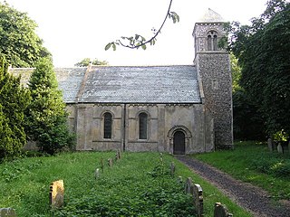
Sotterley, originally Southern-lea from its situation south of the river, is a village and civil parish in the East Suffolk district, in the English county of Suffolk, located approximately 4 miles (6 km) south-east of Beccles and 1.5 miles (2 km) east of Willingham St Mary and Shadingfield. The parish is primarily agricultural with a dispersed population of 113 at the 2011 census. The parish council operates to administer jointly the parishes of Shadingfield, Willingham St Mary, Sotterley and Ellough.

The A145 is an A road in the English county of Suffolk. It runs from east of the town of Beccles, close to the border with Norfolk, to the village of Blythburgh where it joins the A12 road. It is around 11 miles (18 km) in length and single carriageway throughout.

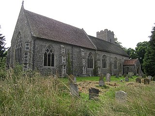
Shadingfield is a village and civil parish in the East Suffolk district of the English county of Suffolk. It is located around 4 miles (6.4 km) south of Beccles in the north of the county.

Willingham St Mary, also known simply as Willingham, is a village and civil parish in the English county of Suffolk located about 3.5 miles (6 km) south of Beccles in the East Suffolk district. At the 2011 United Kingdom census it had a population of 152.

Ellough is a civil parish in the East Suffolk district of the English county of Suffolk, located approximately 3 miles (5 km) south-east of Beccles. The area is sparsely populated with a mid-2005 population estimate of 40. The parish, which has an area of 4.5 square kilometres (1.7 sq mi), borders Worlingham, North Cove, Mutford, Weston, Sotterley, Willingham St Mary and Henstead with Hulver Street. The parish council operates to administer jointly the parishes of Shadingfield, Willingham St Mary, Sotterley and Ellough.

Weston is a village and civil parish in the English county of Suffolk. It is around 2 miles (3 km) south of Beccles in the East Suffolk district. The parish lies either side of the A145 road and is crossed by the Ipswich to Lowestoft railway line. Neighbouring parishes include Ellough, Ringsfield, Willingham St Mary and Shadingfield. The village is largely dispersed with a population of around 230.
Stoven is a village and former civil parish now in the parish of Brampton with Stoven, in the East Suffolk district of the English county of Suffolk. It is located approximately 4.5 miles (7.2 km) north east of Halesworth and 5.5 miles (8.9 km) south of Beccles. In 1961 the parish had a population of 110. In 1987 the parish was merged with Brampton to form Brampton with Stoven and the population of the expanded parish was 427 at the 2011 United Kingdom census. Brampton is located just to the west, Uggeshall to the south and Sotterley to the north.

Brampton with Stoven is a civil parish in the East Suffolk district of the English county of Suffolk. It is located 6 miles (9.7 km) south of the town of Beccles and 4 miles (6.4 km) north-east of Halesworth, with an area of 12 square kilometres (4.6 sq mi). The parish was formed in 1987 from the parishes of Brampton and Stoven, and the two villages are the major population centres in the parish, with Brampton the larger centre with almost all of the parishes services. It borders the parishes of Sotterley, Uggeshall, Sotherton, Westhall, Ilketshall St Andrew and Shadingfield.
Westhall is a village and civil parish in the East Suffolk district, in the county Suffolk, England about 3 miles (5 km) north east of Halesworth, 1 mile (1.6 km) south west of Brampton and 5 miles (8 km) south of Beccles, close to the A145. The mid-2005 population estimate for Westhall parish was 390. Sotherton is located to the south east and Holton to the south west.

Ringsfield is a village and civil parish in the English county of Suffolk. It is 2 miles (3.2 km) south-west of Beccles in the East Suffolk district.

Ilketshall St Lawrence is a village and civil parish in the East Suffolk district of the English county of Suffolk. It is 3 miles (4.8 km) south-east of the market town of Bungay and is part of a group of parishes with similar names known collectively as the Saints.

St Margaret South Elmham is a village and civil parish in the north of the English county of Suffolk. It is 4 miles (6.4 km) south-west of the market town of Bungay in the East Suffolk district. It is one of the parishes surrounding Bungay which are known as The Saints.
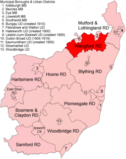
Wangford Rural District was a rural district within the administrative county of East Suffolk between 1894 and 1934. It was created out of the earlier Wangford rural sanitary district. It was named after the historic hundred of Wangford, whose boundaries it closely matched. It contained the group of small villages collectively known as The Saints.

Wainford Rural District was a rural district in East Suffolk, England, between 1934 and 1974. It was created by a merger of the disbanded Wangford Rural District and parts of Blything Rural District, and contained the group of small villages collectively known as The Saints. The name Wainford is linked to that of Wangford, a historic hundred of Suffolk.

