Rickinghall Inferior is a civil parish in the Mid Suffolk district of Suffolk, England. According to the 2011 census there were 233 males and 216 females in this civil parish, for a total population of 449. It includes the western part of the village of Rickinghall and is adjacent to the village and parish of Wattisfield. The old road from the market town of Bury. St Edmunds to the City of Norwich and the town of Great Yarmouth passes through the centre of the village but the new road, the A143, uses a by-pass to the East.
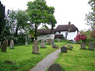
Ashton is a civil parish in the Teignbridge district of Devon, England. According to the 2001 census it had a population of 174, and it had a population of 203 according to the 2011 census. The parish consists of two villages, Higher Ashton and Lower Ashton, and is on the edge of the Dartmoor National Park. The France Brook flows through most of Ashton just south of its main road, and along Ashton's eastern boundary flows the River Teign. The parish is located approximately 13 km north of Newton Abbot, and roughly 10 km to the south west of its nearest city, Exeter. Historically, Ashton has primarily been based inside the agricultural sector, but one of its most notifiable landmarks is the St John the Baptists church located in the Higher Ashton district.
Mutford is a village and civil parish in the East Suffolk District of the English county of Suffolk. The village is 5 miles (8.0 km) south-west of Lowestoft and 4 miles (6.4 km) south-east of Beccles in a rural area. The parish borders Barnby, Carlton Colville, Gisleham, Rushmere, Henstead with Hulver Street, Ellough and North Cove. The village gave its name to the Half Hundred of Mutford which is named in the Domesday Book.

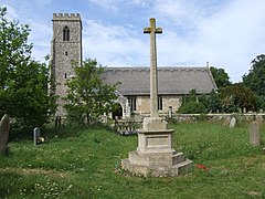
Parham is a village and civil parish in the East Suffolk district of Suffolk in eastern England. Located seven miles north of Woodbridge, in 2005 it had a population of 300, reducing to 263 at the 2011 census and according to the 2011 census there were 129 males and 134 females living at this time.

Rushmere is a village and civil parish in the East Suffolk district of the English county of Suffolk. The village is around 5 miles (8.0 km) south-west of Lowestoft and 5+1⁄2 miles (8.9 km) south-east of Beccles. Neighbouring parishes include Gisleham, Henstead with Hulver Street and Mutford. The Hundred River forms the southern boundary of the parish.

Buttsbury is a village and former 2,079-acre (8.4 km2) civil parish now in the parish of Stock, in the Chelmsford district of Essex, England. Its name is a contraction of Botulph's Pirie, a major saint who died in 680. It is sometimes surmised that the name refers to a tree under which St Botolph preached. In 1931, the civil parish had a population of 1709.

Chattisham is a village and civil parish in Suffolk, England. Located around two miles west of Ipswich and half a mile south of the A1071, it is part of Babergh district. In 2006 its population was 140, increasing to 167 at the 2011 Census. It is in the Belstead Brook electoral division of Suffolk County Council. In the early 1870s, Chattisham was portrayed as: "CHATTISHAM, a parish in Samford district, Suffolk; 2¼ miles NE of Raydon r. station, and 5 SW by W of Ipswich. Post town, Ipswich. Acres, 713. Real property, £1, 427. Pop., 192. Houses, 47. The property is divided among a few. The living is a vicarage in the Diocese of Norwich. Value, £168.* Patron, Eton College. The church has a brass of 1592; and is good. There are a Wesleyan chapel, and charities £6."

Ellough is a civil parish in the East Suffolk district of the English county of Suffolk, located approximately 3 miles (5 km) south-east of Beccles. The area is sparsely populated with a mid-2005 population estimate of 40. The parish, which has an area of 4.5 square kilometres (1.7 sq mi), borders Worlingham, North Cove, Mutford, Weston, Sotterley, Willingham St Mary and Henstead with Hulver Street. The parish council operates to administer jointly the parishes of Shadingfield, Willingham St Mary, Sotterley and Ellough.

Finningham is a village and civil parish in the Mid Suffolk district of Suffolk in the East of England, located approximately 7.5 miles north of Stowmarket and 16 miles from the county town of Ipswich. In 2011 its population was 480.
Hessett is a village and civil parish in the Mid Suffolk district of Suffolk in eastern England. Hessett is located around four miles south-east of Bury St Edmunds. It is a rural village with a single north-south road off which most other roads flow. In 2011 its population was 464 which is towards the highest recorded population since its peak in 1850. Hessett is south of Beyton and west of Drinkstone.

Withersfield is a village and civil parish in the West Suffolk district of Suffolk in eastern England. In 2011 its population was 450. It has a public house and a village hall, and centres on the parish church, St. Mary the Virgin. It is in a rural location, surrounded by farmland, yet only a mile north of the busy market town of Haverhill. Surrounding villages include Great Wratting, West Wickham and Great Thurlow.

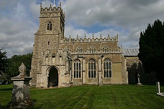
Stansfield is a village and civil parish in the West Suffolk district of Suffolk in eastern England. Located seven miles south-west of Bury St Edmunds, in 2011 its population was 221. The village has an Anglican church dedicated to All Saints. In 1870, John Marius Wilson's Imperial Gazetteer of England and Wales described Stansfield as

Long Marton is a village and civil parish in the Eden District of the English county of Cumbria. In 2011 the population was 827.

Shottisham is a village and civil parish in the East Suffolk district, in the county of Suffolk. It lies in the Wilford Hundred, about four and a half miles south-east of Woodbridge, between the parishes of Sutton, Alderton, Ramsholt and Hollesley, in the Bawdsey peninsula. About three miles from the coast at Hollesley Bay and Shingle Street, the village street overlooks a slight hollow of meads and copses at the road crossing of Shottisham Creek, a tributary brook of the river Deben.

Swilland is a village and civil parish, in the East Suffolk district, in the English county of Suffolk. It is north of the large town of Ipswich. Swilland has a church called St Mary's Church and a pub called The Moon & Mushroom Inn which has been awarded Suffolk Pub of The Year on two occasions by the Evening Star. Swilland shares a parish council with Witnesham called "Swilland and Witnesham Grouped Parish Council".
Twinstead is a village and civil parish in the Braintree district in the county of Essex, England. It shares a parish council with Great Henny and Little Henny called "Hennys', Middleton & Twinstead". It was once part of the Hinckford Hundred, which is a subdivision of a county and has its own court. In 2001 the parish had a population of 165.

Huntingfield is a village near the B1117 road, in the East Suffolk district, in the county of Suffolk, England. The village is close to the source of the River Blyth and the parish is 12 miles from the seaside town of Southwold. Nearby settlements include the town of Halesworth and the villages of Walpole, Heveningham, Cookley and Laxfield.

Great Henny is a village and civil parish in the Braintree district in the county of Essex, England. Nearby settlements include the villages of Little Henny and Twinstead and the Suffolk market town of Sudbury. The hamlet of Henny Street, within the parish, is on the River Stour which forms the parish's eastern border. It shares a parish council with Little Henny and Twinstead called "Hennys', Middleton & Twinstead".

Henstead with Hulver Street is a civil parish in the East Suffolk district of the English county of Suffolk. It is around 5 miles (8.0 km) south-west of Lowestoft, 5 miles (8.0 km) south-east of Beccles and 6 miles (9.7 km) north of the coastal town of Southwold. The parish has an area of 8 square kilometres (3.1 sq mi) and consists of the villages of Henstead, where the parish church is located, and Hulver Street. It borders the parishes of Benacre, Ellough, Gisleham, Kessingland, Mutford, Rushmere, Sotterley and Wrentham.

Hulver Street, also known simply as Hulver, is a hamlet near the market town of Beccles, in the civil parish of Henstead with Hulver Street, in the East Suffolk district, in the county of Suffolk, England. Until 2019 it was in Waveney district. It borders the River Hundred to the north and north-west, Mutford to the north, Henstead to the east, Sotterley to the south, and Ellough to the north-east.