East Garston is a village and civil parish on the River Lambourn, about 5.5 miles (8.9 km) north of Hungerford in West Berkshire. The river flows through the village, dividing many houses from the main road, so that each has a bridge over the river to the front door.

Homersfield, also known as St Mary, South Elmham, is a village and civil parish in the north of the English county of Suffolk. It is in the East Suffolk district, 4 miles (6.4 km) south-west of the market town of Bungay and 3 miles (4.8 km) north-east of Harleston. The official name of the civil parish is St Mary, South Elmham otherwise Homersfield. It is one of the parishes around Bungay known as The Saints.

Beckingham is a village and civil parish in the North Kesteven district of Lincolnshire, England. The population of the civil parish at the 2011 census was 452. It is situated approximately 4 miles (6 km) east from Newark-on-Trent on the A17 road, and on the east bank of the River Witham.

Haddiscoe is a village and civil parish in the South Norfolk district of Norfolk, England, about 16 miles (26 km) southeast of Norwich. The parish is on the county boundary with Suffolk, about 7 miles (11 km) west-northwest of Lowestoft. The parish includes the hamlet of Thorpe-next-Haddiscoe, about 1 mile (1.6 km) north of Haddiscoe village.

All Saints' South Elmham is a village and former civil parish in the north of the English county of Suffolk. The parish was combined with St Nicholas South Elmham in 1737 to form the parish of All Saints and St. Nicholas, South Elmham. It is 5 miles (8.0 km) south of the market town of Bungay in the East Suffolk district. It is one of the villages that make up the area around Bungay known as The Saints.

Mettingham is a village and civil parish in the north of the English county of Suffolk. It is 2 miles (3.2 km) east of the market town of Bungay in the East Suffolk district. It had a population of 211 at the 2011 United Kingdom census.
Frostenden is a village and civil parish in the East Suffolk district of the English county of Suffolk. It is around 8 miles (13 km) south-west of Lowestoft and 3.5 miles (5.6 km) north-west of Southwold and lies on the A12 road between Wrentham and Wangford. Neighbouring parishes include Wrentham, Sotterley, Uggeshall, Wangford with Henham, Reydon and South Cove.

Little Bradley is a small village and civil parish in the West Suffolk district, in the county of Suffolk, England. According to Eilert Ekwall, the meaning of the village name is "the wide clearing." The Domesday Book records the population of Little Bradley in 1086 to be 57. It lies in the valley of the River Stour, north of Haverhill. The population at the 2011 Census was included in the civil parish of Great Bradley.

Icklingham is a village and civil parish in the West Suffolk district of Suffolk in eastern England. It is located about 7 miles (11 km) north-west of Bury St Edmunds, 4 miles (6.4 km) south-east of Mildenhall and 9 miles (14 km) south-west of Thetford in Norfolk. The village is on the A1101 road between Bury St Edmunds and Mildenhall in the north-west of the county. The area around the village, characterised by a sandy gravel-laden soil, is known as Breckland, though an arm of the fen-like peat follows the River Lark past the village.

Little Cornard is a village and civil parish in Suffolk, England. Located around 0.5 miles (0.8 km) from its larger sibling, Great Cornard, on the B1508 road between Sudbury and Colchester, it is part of Babergh district, and has a population of 305, reducing to 286 at the 2011 Census. The parish also includes the hamlet of Workhouse Green.

Ringsfield is a village and civil parish in the English county of Suffolk. It is 2 miles (3.2 km) south-west of Beccles in the East Suffolk district.

Fornham All Saints is a village and civil parish in Suffolk, England in the West Suffolk district. It is north-northwest of the town of Bury St Edmunds and 500m west of Fornham St Genevieve. Fornham All Saints is one of a trio of contiguous villages by the River Lark. The other villages are Fornham St Genevieve and Fornham St Martin.

Waldringfield is a village and civil parish in the East Suffolk district, in the county of Suffolk, England. It is situated on the bank of the River Deben within the Suffolk Coast and Heaths Area of Outstanding Natural Beauty, 4 miles (6.4 km) south of the town of Woodbridge and 8 miles (12.9 km) east of the county town of Ipswich.
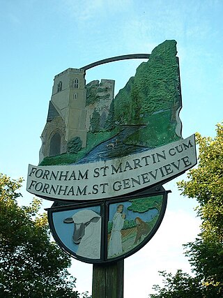
Fornham St Genevieve is a village and civil parish in the West Suffolk district of Suffolk in eastern England. It is one of a trio of contiguous villages by the River Lark. The other villages are Fornham All Saints and Fornham St Martin.

Fornham St Martin is a village and civil parish in the West Suffolk district of Suffolk in eastern England. Located on the northern outskirts of Bury St Edmunds off east and west from the A134, in 2005 its population was 1300. Its parish council is shared with neighbouring Fornham St Genevieve, and is known as Fornham St Martin cum St Genevieve Parish Council. Fornham St Martin is one of a trio of contiguous villages by the River Lark. The other villages are Fornham St Genevieve and Fornham All Saints.

Shottisham is a village and civil parish in the East Suffolk district, in the county of Suffolk. It lies in the Wilford Hundred, about four and a half miles south-east of Woodbridge, between the parishes of Sutton, Alderton, Ramsholt and Hollesley, in the Bawdsey peninsula. About three miles from the coast at Hollesley Bay and Shingle Street, the village street overlooks a slight hollow of meads and copses at the road crossing of Shottisham Creek, a tributary brook of the river Deben.

Hemley is a village and a civil parish in the East Suffolk district, in the English county of Suffolk.

St James South Elmham is a village and civil parish in the north of the English county of Suffolk. It is 4.5 miles (7.2 km) north-west of the market town of Halesworth and 5.5 miles (8.9 km) south-west of Bungay in the East Suffolk district. It is one of the parishes around Bungay known as the Saints.

St Margaret South Elmham is a village and civil parish in the north of the English county of Suffolk. It is 4 miles (6.4 km) south-west of the market town of Bungay in the East Suffolk district. It is one of the parishes surrounding Bungay which are known as The Saints.

Ramsholt Cliff is a 2.1-hectare (5.2-acre) geological Site of Special Scientific Interest north-west of Ramsholt in Suffolk. It is a Geological Conservation Review site, and it is in the Suffolk Coast and Heaths Area of Outstanding Natural Beauty.