Walpole, Suffolk

Last updated

Walpole
Walpole Sign - geograph.org.uk - 82942.jpg
Walpole sign
Suffolk UK location map.svg
Red pog.svg
Walpole
Location within Suffolk
Population238 (2011) [1]
OS grid reference TM366745
District
Shire county
Region
Country England
Sovereign state United Kingdom
Post town Halesworth
Postcode district IP19
Dialling code 01986
Police Suffolk
Fire Suffolk
Ambulance East of England
UK Parliament
List of places
UK
England
Suffolk
52°19′05″N1°28′07″E / 52.3180°N 1.4687°E / 52.3180; 1.4687 Coordinates: 52°19′05″N1°28′07″E / 52.3180°N 1.4687°E / 52.3180; 1.4687

Walpole is a small village and civil parish in the district of East Suffolk in Suffolk, England. Walpole has a parish church (dedicated to St Mary), a redundant chapel (Walpole Old Chapel), but the primary school has closed. The village is on the River Blyth. Nearby settlements include the town of Halesworth and the village of Cookley. It was in the hundred of Blything. It had a population of 238 according to the 2011 census. [1]

Contents

History

The name 'Walpole' derives from the old English meaning 'Pool of the Britons'. [2]

Walpole appears in the Domesday Book, in the hundred of Blything. It has a population of 28 households- 6 villagers, 5 smallholders, and 17 free men. It has 6 men's plough teams, and other resources include a meadow of 6 acres, 30 woodland pigs, and 1 church. The lord in 1086 was Count Alan of Brittany. [3]

In 1870–72, Walpole was described as:

a parish, with a village, in Blything district, Suffolk; 2½ miles SW of Halesworth r. station. Pop., 540. Houses, 115. The manor belongs to Lord Huntingfield. There are an endowed Independent chapel, an endowed school, and charities £11. [4]

Walpole has experienced many boundary changes over time. It was part of the Blything registration district until 1935 when the district was abolished to become part of Blyth, Wainford, and Lothingland registration districts respectively. Walpole joined the Blyth district, transferring a population of 16,640. Walpole remained part of the Blyth district until 1983 when this district too was abolished, to become parts of the Deben and Waveney registration districts respectively. It became part of the Waveney district in 1983 until 2010 when the district was abolished to become part of the Suffolk registration district. [5]

Walpole is known for being a sort of mecca for church crawlers- people who like to study the architecture of the church buildings rather than visiting for religious purposes themselves, with St Mary's Church and Walpole Old Chapel being the attractions here. [6]

Demographics

Total Population of Walpole Civil Parish, Suffolk, as reported by the Census of Population from 1801 to 2011. Walpole population time series 1801-2011.jpg
Total Population of Walpole Civil Parish, Suffolk, as reported by the Census of Population from 1801 to 2011.
Occupational graph for males aged 20 and over in Walpole in 1831 NEW walpole occupation graph.jpg
Occupational graph for males aged 20 and over in Walpole in 1831

Population

Population data on Walpole dates back to as early as 1801, when the population was 494. There have been many fluctuations in the population from 1801 to 2011, with the pattern showing a continuous decrease in numbers from 1831 to 2011. 1831 recorded the highest population figure at 658, whilst the lowest population figure was recorded in 2001 at just 215, a decrease of 67.4% of the 1831 figure. [7] [8] 2011 census shows that 15.6% of the population are aged 0–15, 74.3% aged between 16 and 74, and just 10.1% aged 75 and over. The average age being 46.2 years old. [9]

Housing

The typical housing types in Walpole are detached, semi-detached, and terraced. Housing ownership is typically owner-occupied. [10] Overall average 2014 house prices in Walpole was £225,000. This figure was higher than average house prices in nearby Halesworth where average prices were £168,882 and Bramfield where average house prices were £143,975. Selling prices in the previous year were down 37% of the selling prices in the year before, and down 62% of the 2005 average selling price. [11]

Occupational history

Occupation data for 1831 reflects the social status' of the people of Walpole from that time. 83 of the 135 were classed as labourers and servants, 35 classed as middling sorts, and only 17 were employers and professionals. [12] According to 1831 data, occupation in Walpole for males aged 20 or over was divided into 9 occupational categories. The main category was agricultural labourers, followed by retail and handicrafts. There were no jobs in manufacturing, and very few in other categories. [13] In 1881, males were still predominantly working in the agricultural industry, with 50 out of 96 males involved in agriculture. Work for males did begin to increase however in occupations such as House, Furniture and Decorations, and Food and Lodging. Women, as expected, were very different in 1881 occupational status'. 71 out of 95 females had an unknown occupation, whilst 12 worked in domestic service or offices. Few worked in agriculture, and some worked as professionals or workers in dress. [14] However, data from the most recent census in 2011 shows, as expected, a complete differentiation in occupational status'. Statistics for 2011 show that 123 of residents aged between 16 and 74 are currently in employment, that figure being 51.6% of the total Walpole population. The census data reported that wholesale and retail trade, and education were the biggest sectors in 2011 employment, both at 13%. Manufacturing accounted for 10% of the 2011 employment, compared to 0 in the 1831 census. This would probably be due to the changes in technology which have allowed industries in Walpole and the rest of Britain to shift from the primary sectors of work, to the secondary and tertiary. [15]

Education

The local mixed gender primary school closest to Walpole is situated 2.3 miles away in Bramfield. The school is for children aged between 4-11 and currently has 89 students in total, of which 52.8% are boys and 47.2% are girls. In 2013 the school reported 91% to be achieving Level 4 or above in reading, writing and maths. [16] The last Ofsted inspection was carried out on 21 January 2015 and was rated 'Inadequate'. [17]

Transport

The closest railway station is located approximately 2.9 miles away in nearby Halesworth, approximately a 10-minute drive away from Walpole. Walpole has no local bus service.

Places of interest

St Mary's Church Walpole (Suffolk) St Mary's Church - geograph.org.uk - 68602.jpg
St Mary's Church
Walpole Old Chapel- Congregational Chapel Walpole (Suffolk) Congregational Chapel - geograph.org.uk - 68604.jpg
Walpole Old Chapel- Congregational Chapel

Church of St Mary

Inside the Parish Church is a dish inscribed with the names dedicated to dead soldiers who were from Walpole. Dedicated on 11 May 1949, the Roll of Honour consists of five soldiers from World War One, and four from World War Two. Two of these soldiers are buried in Walpole at St Mary Churchyard. [18] St Mary's church is one of 23 listed buildings in Walpole. The church is listed as Grade II and has been listed for surviving medieval work since 7 December 1966. The core of the church dates back to the 12th century or earlier, with much being restored in 1878. The tower and aisle remains entire still to this date. [19]

Bell Cottage The Old Bell

Previously used as an inn, this is now three private dwellings. Just like the Church of St Mary this is also listed as Grade II and has been listed since 19 March 1985. The building dates back to the early 19th century, made from red brick, and three storeys high. [20]

Congregational Chapel

On the road out of Walpole heading towards Halesworth can be found the Congregational Chapel of Walpole. The worshipping life of the chapel ended in 1970. Despite this, annual services are still held here with the chapel now being in the care of Historic Chapels Trust. The chapel is described as:

an awe-inspiring experience; one of the rare opportunities left to us to obtain a sense of what it was like to be a proud, yet marginalised community in 17th and 18th century rural England. [21]

The Old Thatch

Also listed as Grade II, The Old Thatch has been listed since 19 March 1985. It is a 16th-century timber-framed and plastered cottage with a thatched roof. [22]

Cookley Lake

A family owned two-acre fishing lake open all year round for fishing. [23]

Notable residents

Related Research Articles

Halesworth Town and civil parish in Suffolk, England

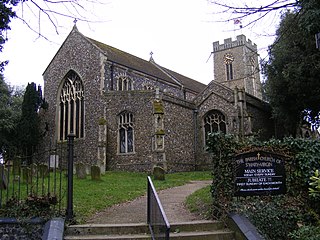
Halesworth is a market town, civil parish and electoral ward in north-eastern Suffolk, England. The population stood at 4,726 in the 2011 Census. It lies 15 miles (24 km) south-west of Lowestoft, on a tributary of the River Blyth, nine miles upstream from Southwold. The town is served by Halesworth railway station on the Ipswich–Lowestoft East Suffolk Line. It is twinned with Bouchain in France and Eitorf in Germany. Nearby villages include Cratfield, Wissett, Chediston, Walpole, Blyford, Linstead Parva, Wenhaston, Thorington, Spexhall, Bramfield, Huntingfield, Cookley and Holton.

Cratfield Human settlement in England

Cratfield is a village in northern Suffolk, England. "It has a population of 292 according to the 2011 census." Neighbouring villages include Laxfield, Metfield, Cookley, Huntingfield, Heveningham. The nearest town, Halesworth, is approximately 6.7 miles (10.7 km) away. Southwold is a popular, nearby coastal town. The market town of Framlingham is also close by.

Blythburgh Human settlement in England

Blythburgh is a village and civil parish in the East Suffolk district of the English county of Suffolk. It is 4 miles (6.4 km) west of Southwold and 5 miles (8.0 km) south-east of Halesworth and lies on the River Blyth. The A12 road runs through the village which is split either side of the road. At the 2011 census the population of the parish was 297. The parish includes the hamlets of Bulcamp and Hinton.

Bramfield, Suffolk Human settlement in England

Bramfield is a village and civil parish in the east of the English county of Suffolk, and in the East Suffolk district. It is 5 miles (8.0 km) south of the market town of Halesworth on the A144 road between Halesworth and the A12 road, one of the main arterial routes through the county. The village is 24 miles (39 km) north-east of the county town of Ipswich and 15 miles (24 km) south-west of the port of Lowestoft. The East Suffolk railway line between Lowestoft and Ipswich passes close to the west of the village with Halesworth railway station being the nearest station.

Friston Human settlement in England

Friston is a village and civil parish in the East Suffolk district, in the county of Suffolk, England. It is 3 miles (5 km) southeast of Saxmundham, its post town, and 4 miles (6 km) northwest of Aldeburgh. The River Alde bounds the village on the south. The surrounding land is chiefly arable. The soil becomes partly marshy in the lower grounds. The village is noted for its early nineteenth century post mill. It is located next to the village of Knodishall.

Wissett Human settlement in England

Wissett is a village and civil parish in the English county of Suffolk. It is 2 miles (3.2 km) north-east of the market town of Halesworth in the East Suffolk district. Historically, it was in the Blything Hundred.

Brandeston Village in Suffolk, England

Brandeston is a village in Suffolk, England on the River Deben 11 miles (18 km) northeast of Ipswich. Brandeston is west of Kettleburgh and northwest of Hoo Green. It is a Parish in Plomesgate district and 3½ miles SW of Framlingham r. station."

Heveningham Village in Suffolk, England

Heveningham is a village and civil parish in the East Suffolk district of Suffolk in eastern England. Located four miles south-west of Halesworth, in 2005 it had a population of 120.

Clopton, Suffolk Human settlement in England

Clopton is a village and civil parish in Suffolk. It is located between Ipswich and Debenham two kilometres north of Grundisburgh on the River Lark. The village is no larger than a series of houses either side of the B1078, surrounded by farm land. The village itself has no clear centre; houses and other buildings are concentrated around the four manors of Kingshall, Brendhall, Rousehall and Wascolies, all of which are mentioned in the Domesday Book of 1086.

Hessett Human settlement in England

Hessett is a village and civil parish in the Mid Suffolk district of Suffolk in eastern England. Hessett is located around four miles south east of Bury St Edmunds. It is a rural village with a single north-south road off which most other roads flow. In 2011 its population was 464 which is towards the highest recorded population since its peak in 1850. Hessett is south of Beyton and west of Drinkstone.

Stonham Aspal Human settlement in England

Stonham Aspal is a village and civil parish in the Mid Suffolk district of Suffolk in eastern England, some five miles (8 km) east of the town of Stowmarket. Nearby villages include Mickfield, Little Stonham and Pettaugh. Its population in 2011 was 601. The village has a primary school. It is set in farmland, but has a busy main road, A1120, running through.

Worlingworth Village in Suffolk, England

Worlingworth is a village and civil parish in the Mid Suffolk district of Suffolk in eastern England, located around ten miles south-east of Diss. In 2011 it had a total population of 802 people.

Withersfield Human settlement in England

Withersfield is a village and civil parish in the West Suffolk district of Suffolk in eastern England. In 2011 its population was 450. It has a public house and a village hall, and centres on the parish church, St. Mary the Virgin. It is in a rural location, surrounded by farmland, yet only a mile north of the busy market town of Haverhill. Surrounding villages include Great Wratting, West Wickham and Great Thurlow.

Stansfield Human settlement in England

Stansfield is a village and civil parish in the West Suffolk district of Suffolk in eastern England. Located seven miles south-west of Bury St Edmunds, in 2011 its population was 221. The village has an Anglican church dedicated to All Saints. In 1870, John Marius Wilson's Imperial Gazetteer of England and Wales described Stansfield as

Ousden Human settlement in England

Ousden is a village and civil parish in the West Suffolk district of Suffolk in eastern England. It is located around six miles west of Bury St Edmunds and 72 miles north of London, and as of 2011, its population is 266. The village has an Anglican church of St Peter's and a chapel in the cemetery dedicated to St Barnabas.

Sibton Human settlement in England

Sibton is a village and civil parish on the A1120 road, in the East Suffolk district, in the English county of Suffolk. It is near the towns of Saxmundham and Halesworth, the village of Peasenhall and the hamlet of Sibton Green. The church is dedicated to St Peter; there is also the remains of a medieval abbey, Sibton Abbey. There is a large stately house set in the grounds of Sibton Park which dates back 1827 in the Georgian period, which is now used as a hotel. The estate consists of 4500 acres, being part of the Wilderness Reserve where there are holiday cottages and a lake. The Parish is also in close proximity to the River Yox which runs past the White Horse Inn and down through Pouy Street, it then goes on past both the A1120 road and a small wooded area called Abbey Woods to pass through the grounds of Sibton Park and then on to Yoxford.

Swilland Human settlement in England

Swilland is a village and civil parish, in the East Suffolk district, in the English county of Suffolk. It is north of the large town of Ipswich. Swilland has a church called St Mary's Church and a pub called The Moon & Mushroom Inn which has been awarded Suffolk Pub of The Year on two occasions by the Evening Star. Swilland shares a parish council with Witnesham called "Swilland and Witnesham Grouped Parish Council".

Sutton is a village and a civil parish on the B1083 road, in the East Suffolk district, in the county of Suffolk, England. Sutton has a pub, a mobile post office and a place of worship. There is also the hamlet of Sutton Street and the Sutton Common estate nearby.

Cookley, Suffolk Human settlement in England

Cookley is a small village and civil parish in the East Suffolk district, in the east of the county of Suffolk, England. Nearby settlements include the town of Halesworth and the village of Walpole. The village includes the church, cottages and a farm that follows the stream which joins the Blyth river at the town of Halesworth. "The church and houses are on the rising ground to the N of the stream."

Huntingfield, Suffolk Human settlement in England

Huntingfield is a village near the B1117 road, in the East Suffolk district, in the county of Suffolk, England. The village is close to the source of the River Blyth and the parish is 12 miles from the seaside town of Southwold. Nearby settlements include the town of Halesworth and the villages of Walpole, Heveningham, Cookley and Laxfield.

References

  1. 1 2 "Walpole (Parish): Key Figures for 2011 Census: Key Statistics". Neighbourhood Statistics. Office for National Statistics. Retrieved 5 February 2014.
  2. "Key to English Place-Names". The University of Nottingham. Retrieved 3 March 2014.
  3. "Open Domesday". Professor J.J.N. Palmer, University of Hull. Retrieved 3 March 2014.
  4. Wilson, John Marius (1870–1872). Imperial Gazetteer of England and Wales (1st ed.). Edinburgh: A. Fullarton & Co. Retrieved 5 February 2014.
  5. "REGISTRATION DISTRICTS IN SUFFOLK". GENUKI. Retrieved 3 March 2014.
  6. "St Mary, Walpole". Suffolk Churches. Retrieved 27 March 2014.
  7. "Total Population". A Vision of Britain through Time. Retrieved 5 March 2014.
  8. "Key Figures for 2001 Census: Census Area Statistics". Neighbourhood Statistics. Retrieved 5 March 2014.
  9. "Age Structure, 2011". Neighbourhood Statistics. Retrieved 6 March 2014.
  10. "The Clink, Walpole, Suffolk". British Streets. Retrieved 6 March 2014.
  11. "House Prices in Walpole, Halesworth, Suffolk". rightmove. Retrieved 6 March 2014.
  12. "Social Status, based on 1831 occupational statistics". A Vision of Britain. Retrieved 20 March 2014.
  13. "Males aged 20 & over, in 9 occupational categories". Vision of Britain. Retrieved 3 March 2014.
  14. "Occupation data classified into the 24 1881 'Orders', plus sex". Vision of Britain. Retrieved 23 April 2014.
  15. "Industry, 2011". Neighbourhood Statistics. Retrieved 6 March 2014.
  16. "Bramfield Church of England Voluntary Controlled Primary School". Department for Education. Retrieved 5 March 2014.
  17. "Bramfield Church of England Voluntary Controlled Primary School". Ofsted. Retrieved 5 March 2014.
  18. "WALPOLE WAR MEMORIAL". Roll of Honour. Retrieved 20 March 2014.
  19. "Church of St Mary, Walpole". British Listed Buildings. Retrieved 12 March 2014.
  20. "Bell Cottage The Old Bell, Walpole". British Listed Buildings. Retrieved 20 March 2014.
  21. "Congregational Chapel, Walpole". Suffolk Churches. Retrieved 20 March 2014.
  22. "The Old Thatch, Walpole". British Listed Buildings. Retrieved 20 March 2014.
  23. "Fishing in Suffolk". Suffolk Tourist Guide. Retrieved 27 March 2014.

Commons-logo.svg Media related to Walpole, Suffolk at Wikimedia Commons