Rendham

Last updated

Entering Rendham on B1119 - geograph.org.uk - 1404900.jpg
Entering Rendham from the south on the B1119
Suffolk UK location map.svg
Red pog.svg
Rendham
Location within Suffolk
Population216 (2011 Census)
OS grid reference TM350645
Civil parish
  • Rendham
District
Shire county
Region
Country England
Sovereign state United Kingdom
Post town Saxmundham
Postcode district IP17
Dialling code 01728
Police Suffolk
Fire Suffolk
Ambulance East of England
UK Parliament
List of places
UK
England
Suffolk
52°13′44″N1°26′13″E / 52.229°N 1.437°E / 52.229; 1.437

Rendham is a village and civil parish on the B1119 road, in the East Suffolk district, in the English county of Suffolk. It is near the town Saxmundham and the village Sweffling.

Contents

Etymology

Rendham comes from Old English and Saxon. Rend is the Old English "rymed" meaning cleared. "Ham" is Saxon, meaning village. Rendham therefore means cleared village, taken from that the village being placed in a clearing by the River Alde, surrounded by woodland. [1]

Geography

Rendham lies on the River Alde, near its confluence with The Gull which diverts to Sweffling downstream from Rendham. The surrounding area is rural, farmland dotted with small areas of woodland. Rendham has two village greens called Rendham Green and The Knoll which are owned by the local Parish. [2]

Between 1870 and 1872, Rendham's location was described in John Marius Wilson's Imperial Gazetteer of England and Wales: [3]

The village stands on an affluent of the river Alde, 3 miles N W by W of Saxmundham r.station; and has a post-office under Saxmundham.

Rendham has a healthy populous, the majority of the population (175 people) in 2011 having very good health or good health. Only 41 people had fair, bad or very bad health. [4] Most people in Rendham have at least one qualification with only 32 people in 2011 not having one and 77 people having a level four qualification or above. [5] Most of Rendham in 2001 was aged between 30 and 59 (116 people) with only a small proportion of younger people (only 60 people aged between zero and 19) compared to 20-year-olds and over making 202 of the population with 116 of those people as stated before being between 30 and 59. [6] 61% of the population in 2011 was Christian (132 people). [7]

Health status of the residents of Rendham in 2011. Retrieved from Neighborhood Statistics. Rendham Health Status Graph.jpg
Health status of the residents of Rendham in 2011. Retrieved from Neighborhood Statistics.

Rendham has traditionally been a farming village with the majority of males in the past being employed in agriculture. In the 18th century, nearly all villagers were involved in agriculture in some way as farm workers, farmers or horticulturalists. [8] By 1881, 46 males were involved in agriculture, more than all the other occupational orders combined at the time. Agriculture was key in the village due to its relative isolation from market towns such as Saxmundham meaning independent sources of food were needed. Occupational orders of females in 1881 is mainly unknown, however 19 were in domestic service or offices. [9]

Most people in Rendham were employed in professional occupations in 2011 (24). Associate Professional and Technical Occupations employed the next largest number of residents at 20. Managers, directors and senior officials make up 17 of Rendhams population. [10] This is a change from 1881 where the majority of residents were employed under agriculture to support the food production of the village (46 males of the villages 367 population). This change could be down to two things. The first being population decline from 1881 (367 people) to 2011 (216 people) meaning not as many crops were needed and males moved from agriculture to other employment. The second is more likely and is due to the changing economy from 1881 to 2011. Between the years, the United Kingdom has gone from a primary sector based economy where industry revolves around farming and fishing, into one dominated by the tertiary sector based on services. People moved away from primary agriculture occupations (the largest employer in 1881) into tertiary based jobs (the largest employer in 2011).

Nearly all of the housing in Rendham in 2011 was detached (76 houses) or semi detached (24 houses). The number of detached houses (which are usually more expensive than other houses) shows the village is affluent and as stated previously is populated by people with professional occupations and high income. [11] This affluence is demonstrated further by most houses having three bedrooms or more (89 houses), the majority having three bedrooms (51 houses) and only 12 houses having one or two bedrooms (in 2011). [12] 130 people or 69.9% of the population in 2011 were living as a couple (married or civil partnership) showing the spare rooms were probably used for visitors and not children as the number of children is low (60 people 19 or below). [13]

History

Bronze head of the Emperor Claudius, found in the River Alde. British Museum, cat.no. PRB 1965.12-1.1 Claudius BritishMuseum PRB 1965.12-1.1.jpg
Bronze head of the Emperor Claudius, found in the River Alde. British Museum, cat.no. PRB 1965.12-1.1

The first inhabitants of Rendham were believed to have settled in the 1st century, due to the river providing food (fish and river birds), fertile soils from flooding and transport by boat. In AD60 Queen Boudicca ruled the area of Suffolk as leader of the Iceni, 20 years into the Roman invasion of Britain. There is evidence that residents of Rendham joined her army and were present at the storming of the Temple of Claudius in Colchester. In 1907 two Rendham schoolboys (Arthur Baxter and Arthur Godbold) found an object in the River Alde at Rendham. After a few years a schoolmaster from Benhall purchased the sculpture for five shillings. It was the looted head of the Emperor Claudius from a bronze statue in Colchester, plundered by the Iceni. It later sold for £15,500 in Sotheby's to the British Museum (where it is on display currently), annoying residents of Rendham as they were not mentioned. A replica head is in the history corner of St Michael's church. [14] Following the restoration of the monarchy in 1660, Rendham became popular amongst non-conformists. A congregation chapel was formed in 1680 and by 1740 its popularity meant people attended from as far out as Debenham and a new chapel was built. This was finished in 1750 and had a donation from famous hymn writer Dr. Isaac Watts. Rendham Chapel was later attended by painter Henry Bright. Rendham Chapel became the United Reform Church and closed in 1977. [15]

Related Research Articles

<span class="mw-page-title-main">Sutton, Peterborough</span> Human settlement in England

Sutton is a small village and civil parish in the Peterborough district, in the north-west of Cambridgeshire, England. Situated about 5.7 miles from Peterborough and approximately half a mile south of the A47 road.

<span class="mw-page-title-main">Badingham</span> Human settlement in England

Badingham is a civil parish in the East Suffolk district of eastern England, in the county of Suffolk. It is situated 21.8 miles north east of Ipswich, 35 miles (56 km) away from Norwich and 13 miles (21 km) away from the coast. With the road "A1120" slicing through the middle of the parish. Badingham's name is Anglo-Saxon and means "the farmstead of Bada’s people". Badingham contains a significant number of farms, sparse amount of housing, numerous B&Bs as well as St. John's Church.

<span class="mw-page-title-main">Belstead</span> Human settlement in England

Belstead is a village and civil parish in the Babergh district of the English county of Suffolk. Located on the southern edge of Ipswich, around 3 miles (5 km) south-west of Ipswich town centre. It had a population of 202 according to the 2011 census. Belstead has amenities such as a village hall, St Mary's the Virgin Church, The bridge school for children with learning difficulties and Belstead Brook Hotel and Spa. It is in the Belstead Brook electoral division of Suffolk County Council.

<span class="mw-page-title-main">Boyton, Suffolk</span> Human settlement in England

Boyton is a village and civil parish in the East Suffolk district of Suffolk, England, about eight miles east of Woodbridge, and close to Orford Ness. Boyton is a small village in South East England and is part of the heritage coast. In the Domesday Book of 1086 Boyton was recorded under the name "Bohtuna". The village has a number of facilities within the surrounding area, for instance Hollesley primary school, a village primary school for children aged 4–11 years. Boyton village hall is becoming a focus for new village activities, and HM Prison Hollesley Bay is also located not far from the village centre. In the 1870s Boyton was described by John Marius Wilson as:

<span class="mw-page-title-main">Friston</span> Human settlement in England

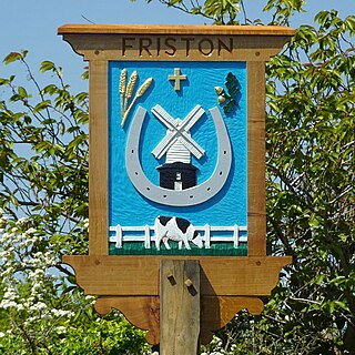
Friston is a village and civil parish in the East Suffolk district, in the county of Suffolk, England. It is 3 miles (5 km) southeast of Saxmundham, its post town, and 4 miles (6 km) northwest of Aldeburgh. The River Alde bounds the village on the south. The surrounding land is chiefly arable. The soil becomes partly marshy in the lower grounds. The village is noted for its early nineteenth century post mill. It is located next to the village of Knodishall.

<span class="mw-page-title-main">Hunsonby</span> Village in Cumbria, England

Hunsonby is a village and civil parish in the Eden district of Cumbria, England, 7 miles (11 km) north east of Penrith. The parish is located 28 miles (45 km) south east of the city of Carlisle. Within the parish is the ancient stone circle of Long Meg and Her Daughters but not the nearby standing stone of Little Meg which is located near Langwathby. In 2011 the Census reported the parish to have a total population of 388.

<span class="mw-page-title-main">Parham, Suffolk</span> Village and civil parish in Suffolk, England

Parham is a village and civil parish in the East Suffolk district of Suffolk in eastern England. Located seven miles north of Woodbridge, in 2005 it had a population of 300, reducing to 263 at the 2011 census and according to the 2011 census there were 129 males and 134 females living at this time.

<span class="mw-page-title-main">Farnham, Suffolk</span> Human settlement in England

Farnham is a village and civil parish about 3 miles (4.8 km) south-west of Saxmundham in the English county of Suffolk on the A12 road. Farnham is located west of Friday Street, south of Benhall Low Street and north-east of Stratford St Andrew.

<span class="mw-page-title-main">Peover Superior</span> Human settlement in England

Peover Superior is a former civil parish, now in the parish of Peover Superior and Snelson, in the unitary authority area of Cheshire East and the ceremonial county of Cheshire, England. It is described by the Office for National Statistics as a village surrounded by inhabited countryside. The civil parish included the village of Over Peover and the hamlet of Peover Heath. In 2011 the parish had a population of 666.

<span class="mw-page-title-main">Kexby, Lincolnshire</span> Village in Lincolnshire, England

Kexby is a small village and civil parish in the West Lindsey district of Lincolnshire, England. The population of the civil parish at the 2011 census was 340. It lies at the side of the B1241 road, and is situated 4 miles (6 km) south-east of Gainsborough and 11 miles (18 km) north-west of the city and county town of Lincoln.

<span class="mw-page-title-main">Heveningham</span> Village in Suffolk, England

Heveningham is a village and civil parish in the East Suffolk district of Suffolk in eastern England. Located four miles south-west of Halesworth, in 2005 it had a population of 120.

<span class="mw-page-title-main">Fakenham Magna</span> Human settlement in England

Fakenham Magna is a village and civil parish in the West Suffolk district of Suffolk in eastern England. The meaning of the word 'Fakenham' can be split into two: 'Faken' and 'ham', both of which derive from Old English. The former refers to somebody by the name of 'Facca', with the latter meaning 'a village / a homestead', making the direct translation 'Facca's homestead'. 'Magna' translates from Latin as 'great', hence the alternative name of the village of 'Great Fakenham'. During World War Two, however, the village was referred to as 'Little Fakenham', which was used to avoid confusion with the larger civil parish of Fakenham in Norfolk.

<span class="mw-page-title-main">Westley, Suffolk</span> Human settlement in England

Westley is a village and civil parish in the West Suffolk district of Suffolk in eastern England. It is located south of Junction 42 of the A14 providing primary access to adjacent market towns Bury St Edmunds (East) and Newmarket (West). The village consists of two central roads: Fornham Lane and Hill Road running north and south through the parish, with adjoining roads accommodating Westley's total population of 183.

<span class="mw-page-title-main">Sourton</span> Village in Devon, England

Sourton is a small village and civil parish in West Devon, England. It lies about 4 miles (6.4 km) south-west of Okehampton. It is at the north-western extremity of Dartmoor, a National Park of England and Wales, and lies along the A386 road. The historic map of Sourton shows that it is located near a river and the Sourton forest this can be seen in the image below.

<span class="mw-page-title-main">Lamarsh</span> Human settlement in England

Lamarsh is a village and a civil parish in the Braintree District, in the county of Essex, England. It is near the large village of Bures and the village of Alphamstone. The village is west of the River Stour. It has a pub, a village hall and a church called The Friends of Holy Innocents Church. The civil parish's name, Lamarsh, comes from the phrase "Loamy marsh". This is derived from the Old English terms lām and mersc, which translate into loam or clay and a marsh respectively.

<span class="mw-page-title-main">Walpole, Suffolk</span> Human settlement in England

Walpole is a small village and civil parish in the district of East Suffolk in Suffolk, England. Walpole has a parish church, a redundant chapel, but the primary school has closed. The village is on the River Blyth. Nearby settlements include the town of Halesworth and the village of Cookley. It was in the hundred of Blything. It had a population of 238 according to the 2011 census.

<span class="mw-page-title-main">Eyke</span> Human settlement in England

Eyke is a village and a civil parish in the East Suffolk district, in the English county of Suffolk. It is located on the A1152 road near the town of Woodbridge. Eyke has a primary school, the manor house of Lord and Lady Lucas with scenic pond and horse paddock, and a pub. The mediaeval parish church of All Saints was restored in the 1860s. Services are normally held on the first and third Sundays of the month.

<span class="mw-page-title-main">Sibton</span> Human settlement in England

Sibton is a village and civil parish on the A1120 road, in the East Suffolk district, in the English county of Suffolk. It is near the towns of Saxmundham and Halesworth, the village of Peasenhall and the hamlet of Sibton Green. The church is dedicated to St Peter; there is also the remains of a medieval abbey, Sibton Abbey. There is a large stately house set in the grounds of Sibton Park which dates back 1827 in the Georgian period, which is now used as a hotel. The estate consists of 4500 acres, being part of the Wilderness Reserve where there are holiday cottages and a lake. The Parish is also in close proximity to the River Yox which runs past the White Horse Inn and down through Pouy Street, it then goes on past both the A1120 road and a small, wooded area called Abbey Woods to pass through the grounds of Sibton Park and then on to Yoxford.

Sutton is a village and a civil parish on the B1083 road, in the East Suffolk district, in the county of Suffolk, England. Sutton has a pub, a mobile post office and a place of worship. There is also the hamlet of Sutton Street and the Sutton Common estate nearby.

<span class="mw-page-title-main">Shobrooke</span> Village in Devon, England

Shobrooke is a village, parish and former manor in Devon, England. The village is situated about 1 1/2 miles north-east of Crediton. It is located close to Shobrooke park. The river Shobrooke Lake flows through the village. It had a population of 537 according to the 2011 census. The name Shobrooke is derived from the old English words of succa and brōc, and translates as goblin brook.

References

  1. Twinch, Carol. "History of Rendham". rendham.onesuffolk.net/. onesuffolk. Retrieved 17 March 2015.
  2. "History of Rendham". onesuffolk. 11 February 2015. Retrieved 3 March 2015.
  3. Wilson, John Marius (1870–1872). Gazetteer of England and Wales. Edinburgh: A. Fullerton & Co. Retrieved 27 January 2015.
  4. "General Health, 2011". Neighborhood Statistics. Office for National Statistics. Retrieved 27 March 2015.
  5. "Highest Level of Qualification, 2011". Neighborhood Statistics. Office for National Statistics. Retrieved 27 March 2015.
  6. "Age Structure, 2001". Neighborhood Statistics. Office for National Statistics. Retrieved 27 March 2015.
  7. "Religion, 2011". Neighborhood Statistics. Office for National Statistics. Retrieved 27 March 2015.
  8. Twinch, Carol. "History of Rendham". rendham.onesuffolk.net/home/rendham-story/. onesuffolk. Retrieved 17 March 2015.
  9. "GB Historical GIS / University of Portsmouth, Rendham CP/AP through time | Industry Statistics | Occupation data classified into the 24 1881 'Orders', plus sex, A Vision of Britain through Time" . Retrieved 16 March 2015.
  10. "Lead View Table, Rendham, Occupation 2011". www.ons.gov.uk/ons/index.html. Office for National Statistics. Retrieved 16 March 2015.
  11. "Accommodation Type- Households 2011". Neighbourhood Statistics. Office for National Statistics. Retrieved 27 March 2015.
  12. "Number of Bedrooms, 2011". Neighbourhood Statistics. Office for National Statistics. Retrieved 27 March 2015.
  13. "Living Arrangements, 2011". Office for National Statistics. Retrieved 27 March 2015.
  14. Twinch, Carol. "History of Rendham". onesuffolk. Retrieved 17 March 2015.
  15. Twinch, Carol. "History of Rendham". rendham.onesuffolk.net/home/rendham-story/. onesuffolk. Retrieved 17 March 2015.