Woodbridge is a port town and civil parish in the East Suffolk district of Suffolk, England. It is 8 miles (13 km) up the River Deben from the sea. It lies 7 miles (11 km) north-east of Ipswich and forms part of the wider Ipswich built-up area and is close to Kesgrave.
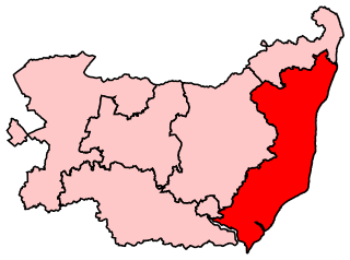
Suffolk Coastal is a parliamentary constituency in the county of Suffolk, England which has been represented in the House of Commons of the UK Parliament since 2010 by Thérèse Coffey, a Conservative Member of Parliament. She has served as Secretary of State for Environment, Food and Rural Affairs since October 2022.

Whitburn is a village and former civil parish, now in the unparished area of Boldon, in the South Tyneside district, in the metropolitan county of Tyne and Wear on the coast of North East England. It is located 3 miles (4.8 km) north of the city of Sunderland and 4 miles (6.4 km) south of the town of South Shields. Historically, Whitburn was a part of County Durham. Other nearby population centres include Seaburn, Cleadon and Marsden. The village lies on a south-facing slope, part of Durham's Magnesian Limestone plateau, which overlooks Sunderland. The population for the combined Whitburn and Marsden Ward in the 2011 UK Census was 7,448. For much of its history, Whitburn was a fishing and agricultural community. The village contains three schools, three churches, a cricket club, recreational grounds, a pub and a variety of shops.

Oakley is a village in the borough of Basingstoke and Deane in Hampshire, England, located around 4.5 miles (7 km) west of Basingstoke. In the 2001 Census it had a population of 5,322. Together with the smaller village of Deane, it forms the Oakley and Deane civil parish renamed as Oakley at the 2011 Census.

Culford is a village and civil parish about 4 miles (6 km) north of Bury St Edmunds and 62 miles (100 km) north east of London in the West Suffolk district of Suffolk, England.

Holtby is a small village and civil parish in the unitary authority of the City of York in North Yorkshire, England. The population at the 2011 Census was 166. It lies close to the A166 about 5 miles (8 km) east of York.
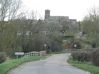
Brinkworth is a village and civil parish in northern Wiltshire, England. The village lies between Royal Wootton Bassett and Malmesbury, about 1 mile (1.6 km) north of the M4 motorway and 9 miles (14 km) west of Swindon.

Eppleby is a village and civil parish in the Richmondshire district of North Yorkshire, England. It is located about 7 miles (11 km) north of Richmond. According to the 2011 United Kingdom census, the population of the parish was 269.
Wrekenton is a residential area in Gateshead, located around 3.5 miles (5.6 km) from Newcastle upon Tyne, 11 miles (18 km) from Sunderland, and 14 miles (23 km) from Durham. In 2011, Census data for the Gateshead Metropolitan Borough Council ward of High Fell recorded a total population of 6,110.
Tunstall is a village and civil parish in the Richmondshire district of North Yorkshire, England about 2 miles (3.2 km) west of Catterick Village and the A1(M) motorway. It had a population of 253 increasing to 271 at the 2011 census.
Sunniside is a village in the Metropolitan Borough of Gateshead, which is located around 5.5 miles (9 km) from Newcastle upon Tyne. Prior to the creation of the county of Tyne and Wear in 1974, it was part of Whickham Urban District, which in turn formed a part of County Durham.
Heworth is a residential area in Gateshead, located around 3 miles (4.8 km) from Newcastle upon Tyne, 11 miles (18 km) from Sunderland, and 17 miles (27 km) from Durham. In 2011, Census data for the Gateshead Metropolitan Borough Council ward of Heworth and Pelaw recorded a total population of 9,100.

Greystoke is a village and civil parish on the edge of the Lake District National Park in Cumbria, England, about 4 miles (6.4 km) west of Penrith. At the 2001 census the parish had a population of 642, increasing marginally to 654 at the 2011 Census. The village centres on a green surrounded by stone houses and cottages.
Henshaw is a small village and civil parish in Northumberland, within the vicinity of the ancient Hadrian's Wall. It is located around 11.5 miles (19 km) from Hexham, 25.5 miles (41 km) from Carlisle, and 33 miles (53 km) from Newcastle upon Tyne.

Horsley is a small village and civil parish in Northumberland, England. The village lies around 11 miles (18 km) from Newcastle upon Tyne and 12 miles (19 km) from Hexham.
High Melton is a village and civil parish in the City of Doncaster in South Yorkshire, England. It had a population of 339 in 2001, reducing to 300 at the 2011 Census.

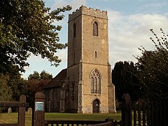
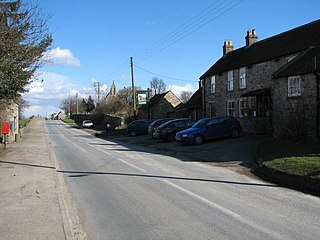
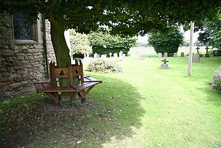
Ufford is a village and civil parish in Suffolk, England. Its population of 808 at the 2001 census rose to 948 at the 2011 Census and was estimated at 1,008 in 2019. The village lies 2 miles south-south-west of Wickham Market and 13 miles north-east of Ipswich. The main road through the village was renumbered B1438 after its replacement as a trunk road by the new A12.
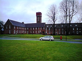
St Audry's Hospital was a psychiatric hospital in Melton, Suffolk, England.
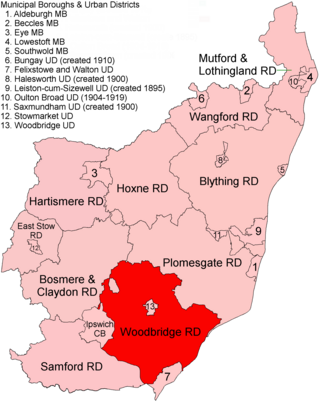
Woodbridge Rural District was a rural district within the administrative county of East Suffolk between 1894 and 1934. It was created out of the earlier Woodbridge rural sanitary district. It surrounded the town of Woodbridge, which had earlier been created as an urban district.

Roughlee Booth is a civil parish located in Pendle, Lancashire. It is approximately 449.43 hectares in size and situated in the Forest of Bowland AONB. It borders on the parishes of Blacko, Barrowford, Old Laund Booth, Goldshaw Booth and Barley-with-Wheatley Booth. It is part of the Forest of Bowland Area of Outstanding Natural Beauty (AONB). It contains the village of Roughlee and hamlets of Crow Trees and Thornley Holme. According to the United Kingdom Census 2011, the parish has a population of 318, a decrease from 328 in the 2001 census.