
The Great River Road is a collection of state and local roads that follow the course of the Mississippi River through ten states of the United States. They are Minnesota, Wisconsin, Iowa, Illinois, Missouri, Kentucky, Tennessee, Arkansas, Mississippi and Louisiana. It formerly extended north into Canada, serving the provinces of Ontario and Manitoba.
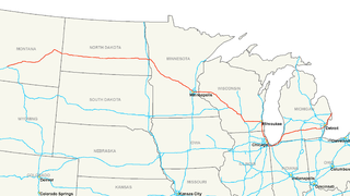
Interstate 94 (I-94) is an east–west Interstate Highway connecting the Great Lakes and northern Great Plains regions of the United States. Its western terminus is in Billings, Montana, at a junction with I-90; its eastern terminus is in Port Huron, Michigan, where it meets with I-69 and crosses the Blue Water Bridge into Sarnia, Ontario, Canada, where the route becomes Ontario Highway 402. It thus lies along the primary overland route from Seattle to Toronto, and is the only east–west Interstate highway to form a direct connection into Canada.

The Empire Builder is an Amtrak long-distance passenger train that operates daily between Chicago and – via two sections west of Spokane – Seattle and Portland. Introduced in 1929, it was the flagship passenger train of the Great Northern Railway and its successor, the Burlington Northern, and was retained by Amtrak when it took over intercity rail service in 1971.

The Minneapolis, Northfield and Southern Railway was an 87-mile-long (140 km) American short line railroad connecting Minneapolis and Northfield, Minnesota. It was incorporated in 1918 to take over the trackage of the former Minneapolis, St. Paul, Rochester and Dubuque Electric Traction Company, also known as the Dan Patch Lines. On 2 June 1982 it was acquired by the Soo Line Railroad, which operated it as a separate railroad until merging it on January 1, 1986.

The Short Line Bridge is a truss bridge that spans the Mississippi River in Minneapolis, Minnesota, United States. It was originally built in the 1880s and upgraded a few years later by Chicago, Milwaukee, St. Paul and Pacific Railroad and was designed by American Bridge Company.

Northern Pacific Bridge #9 is a deck truss bridge that spans the Mississippi River in Minneapolis, Minnesota, between the Seven Corners area and the University of Minnesota campus. It was built in 1924 and was designed by Frederick W. Cappelen. Railroad use of the bridge ended in 1981, and in 1999 the bridge was opened to bicycles and pedestrians. It replaced the former Northern Pacific "A Line" bridge.

The Twin Cities Zephyr was a streamlined passenger train on the Chicago, Burlington and Quincy Railroad (CB&Q), running between Chicago and the Twin Cities of Minneapolis and Saint Paul in Minnesota. It was the second Zephyr service introduced by CB&Q after the record-setting Denver–Chicago "dawn to dusk dash" of the Pioneer Zephyr trainset.

Winona is a historic train station in Winona, Minnesota, United States. It is served by Amtrak's daily Empire Builder service. It was originally built in 1888 by the Chicago, Milwaukee, St. Paul and Pacific Railroad, known later as the Milwaukee Road. A former Milwaukee Road freight house also exists here.

The Minneapolis Great Northern Depot, also known as Great Northern Station, was a passenger railroad station which served Minneapolis, Minnesota, USA. It was built in 1913 and demolished in 1978. It was located on Hennepin Avenue next to the Hennepin Avenue Bridge and across the street from the main Minneapolis Post Office.
Milwaukee Road Depot can refer to the following former and active train stations used by the Chicago, Milwaukee, St. Paul and Pacific Railroad:

Maple Springs is an unincorporated community in Pepin Township, Wabasha County, Minnesota, United States, along the Mississippi River and Lake Pepin. The Mississippi River and King Creek meet at Maple Springs.
Frontenac is an unincorporated community and census-designated place (CDP) in Florence Township, Goodhue County, Minnesota, United States, on the Mississippi River. As of the 2010 census, its population was 282.

Ashdale Junction is an unincorporated community in Carroll County, Illinois, United States. Ashdale Junction is located along the Milwaukee Road railroad line east of Mount Carroll.
The River Subdivision or River Sub is a railway line along the Mississippi River that runs approximately 124 miles (200 km) from Saint Paul, Minnesota south to La Crescent. U.S. Highway 61 closely parallels the route between La Crescent and Red Wing,MN. The line is operated by the Canadian Pacific Railway. BNSF Railway operates a complementary St. Croix Subdivision which traces the eastern side of the river in Minnesota and Wisconsin. The two routes share some track between Saint Paul and St. Croix Jct., near Hastings, Minnesota.
The Tomah Subdivision or Tomah Sub is a railway line that runs about 103 miles (166 km) from La Crosse, WI in the west to Portage, Wisconsin in the east.
The Canadian Pacific Railway Merriam Park Subdivision or Merriam Park Sub, also known as the Short Line, is a railway line in Saint Paul, Minnesota, which runs from Pig's Eye Yard and the CP River Subdivision in the east to the Short Line Bridge over the Mississippi River in the west, where rails continue as part of the Minnesota Commercial Railway. It was named for John L. Merriam, a Minnesota banker and politician. Completed by the Chicago, Milwaukee and St. Paul Railroad in 1880, it shortened the route Milwaukee Road trains took between downtown Saint Paul and downtown Minneapolis. Previous trains would exit Saint Paul and follow the Mississippi River southwest until crossing at Fort Snelling where they would follow the path of today's Hiawatha Avenue and METRO Blue Line toward the Milwaukee Road Depot. Originally built as an interurban route, it was eventually converted for heavy rail traffic because the Twin City Rapid Transit streetcar system had taken over the local transit market.
The Mankato Subdivision or Mankato Sub is a railway line operated by the Union Pacific Railroad. It runs generally southwest, starting at Chestnut Street in Saint Paul, Minnesota, where it crosses the Mississippi River, then runs south along the Mississippi and then the Minnesota River to Mankato, where it turns away from the river and continues west to St. James. From there Union Pacific's rails continue southwest toward Sioux City, Iowa, as the railroad's Worthington Subdivision.
The Watertown Subdivision or Watertown Sub is a railway line in Wisconsin operated by Canadian Pacific Railway (CP) through its primary United States subsidiary, the Soo Line Railroad. It meets CP's Tomah Subdivision in the west in Portage and runs to Milwaukee in the east where it meets the C&M Subdivision. The Tomah Subdivision had previously been operated by the Chicago, Milwaukee, St. Paul and Pacific Railroad (CMStP&P), though the Soo Line Railroad took it over when the Milwaukee Road folded. Canadian Pacific gained ownership via taking over the SOO Line.

Dresbach is an unincorporated community in Dresbach Township, Winona County, Minnesota, United States.

Valley Junction is an unincorporated community located in the town of Byron, Monroe County, Wisconsin, United States. It is located at the intersection of Wisconsin Highway 173, County Highway G, and County Highway N.


