
Minnesota is a state in the Upper Midwest, Great Lakes, and northern regions of the United States. Minnesota was admitted as the 32nd U.S. state on May 11, 1858, created from the eastern half of the Minnesota Territory. The state has a large number of lakes, and is known by the slogan the "Land of 10,000 Lakes". Its official motto is L'Étoile du Nord.
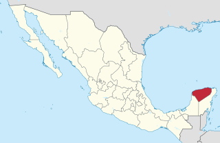
Yucatán, officially the Free and Sovereign State of Yucatán, is one of the 31 states which, with Mexico City, comprise the 32 Federal Entities of Mexico. It is divided into 106 municipalities, and its capital city is Mérida.

Mérida is the capital and largest city in Yucatan state in Mexico, as well as the largest city of the Yucatán Peninsula. The city is located in the northwest part of the state, about 35 kilometres off the coast of the Gulf of Mexico. The city is also the municipal seat of the Municipality of Mérida, which includes the city and the areas around it.

The United Mexican States is a federal republic composed of 31 states and the capital, Mexico City, an autonomous entity.

The Caste War of Yucatán (1847–1901) began with the revolt of native Maya people of Yucatán, Mexico against the European-descended population, called Yucatecos. The latter had long held political and economic control of the region. A lengthy war ensued between the Yucateco forces in the north-west of the Yucatán and the independent Maya in the south-east. There was regular raiding between them.

The Maya peoples are an ethnolinguistic group of indigenous peoples of Mesoamerica. They inhabit southern Mexico, Guatemala, Belize, El Salvador and Honduras. The overarching term "Maya" is a collective designation that includes the peoples of the region which share some degree of cultural and linguistic heritage; however, the term embraces many distinct populations, societies and ethnic groups that each have their own particular traditions, cultures and historical identity.

Hurricane Isidore was the ninth named storm and the second hurricane in the 2002 Atlantic hurricane season. Isidore was the fifth of eight named storms to occur in September. The tropical cyclone peaked as a Category 3 hurricane, causing damage as well as four fatalities in Jamaica, Cuba, Mexico, and the United States. Isidore is noted for threatening to strike the northern Gulf Coast as a Category 4 hurricane, but instead striking as a moderate tropical storm due to a track change that brought the storm over the Yucatán Peninsula for over a day, which significantly weakened the cyclone. Its primary impact was the heavy rainfall which fell across southeast Mexico and from the central United States Gulf coast into the Ohio Valley.
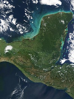
The Yucatán Peninsula, in southeastern Mexico, separates the Caribbean Sea from the Gulf of Mexico, with the northern coastline on the Yucatán Channel. The peninsula lies east of the Isthmus of Tehuantepec, a northwestern geographic partition separating the region of Central America from the rest of North America. It is approximately 181,000 km2 (70,000 sq mi) in area, and is almost entirely composed of limestone.
Mexico has experienced many changes in territorial organization during its history as an independent state. The territorial boundaries of Mexico were affected by presidential and imperial decrees. One such decree was the Law of Bases for the Convocation of the Constituent Congress to the Constitutive Act of the Mexican Federation, which determined the national land area as the result of integration of the jurisdictions that corresponded to New Spain, the Captaincy General of Yucatán, the Captaincy General of Guatemala and the autonomous Kingdoms of East and West. The decree resulted in the independence from Spain.

The Republic of Yucatán was a sovereign state during two periods of the nineteenth century. The first Republic of Yucatán, founded May 29, 1823, willingly joined the Mexican federation as the Federated Republic of Yucatán on December 23, 1823, less than seven months later. The second Republic of Yucatán began in 1841, with its declaration of independence from the Mexican Federation. It remained independent for seven years, after which it rejoined the United Mexican States. The area of the former republic includes the modern Mexican states of Yucatán, Campeche and Quintana Roo. The Republic of Yucatán usually refers to the Second Republic (1841–1848).
Yucatán is a Mexican state.

Chichen Itza was a large pre-Columbian city built by the Maya people of the Terminal Classic period. The archaeological site is located in Tinúm Municipality, Yucatán State, Mexico.

The Captaincy General of Yucatán was an administrative district of colonial Spain, created in 1617 to provide more autonomy for the Yucatán Peninsula, previously ruled directly by a simple governor under the jurisdiction of Audiencia of Mexico. Its creation was part of the, ultimately futile, Habsburg attempt in the late 16th century to prevent incursion into the Caribbean by foreign powers, which also involved the establishment of Captaincies General in Puerto Rico, Cuba, and neighboring Guatemala. With the addition of the title of captain general to the governor of Yucatán, the province gained greater autonomy in administration and military matters. Unlike in most areas of Spanish America, no formal corregidores were used in Yucatán, and instead the governor-captain general relied on other subordinate officials to handle the oversight of local districts. The Captaincy General remained part of the Viceroyalty of New Spain, with the viceroy retaining the right to oversee the province's governance, when it was deemed necessary, and the Audiencia of Mexico taking judicial cases in appeal. The province and captaincy general covered the territory that today are the States of Campeche, Quintana Roo, Tabasco, Yucatán, and nominally the northern areas of Petén and Belize.

This is a list of the National Register of Historic Places listings in Houston County, Minnesota. It is intended to be a complete list of the properties and districts on the National Register of Historic Places in Houston County, Minnesota, United States. The locations of National Register properties and districts for which the latitude and longitude coordinates are included below, may be seen in an online map.

Tizimín is a city located in the Tizimín Municipality in the Mexican state of Yucatán, It is located in the Coastal Zone of the same state.

David Daniel Nelson is a United States Foreign Service Officer and a career member of the Senior Foreign Service. He has notably served as the United States Ambassador to Uruguay.

Yucatan is an unincorporated community in eastern Callaway County, Missouri, United States. The community is on Missouri Route D about four miles south of I-70. Lake Lochaweeno is about two miles to the southwest.


