
Nobles County is a county in the U.S. state of Minnesota. As of the 2010 United States Census, the population was 21,378. Its county seat is Worthington.

Murray County is a county in the U.S. state of Minnesota. The population was 8,725 at the 2010 United States Census. Its county seat is Slayton.

Maple Ridge Township is a township in Beltrami County, Minnesota, United States. The population was 108 as of the 2000 census.
Woodbury is a city in Washington County, Minnesota. It is part of the Twin Cities metropolitan area. Woodbury is situated east of Saint Paul along Interstate 94. The 2018 population for Woodbury was 71,306, making it the 9th most populous city in Minnesota.
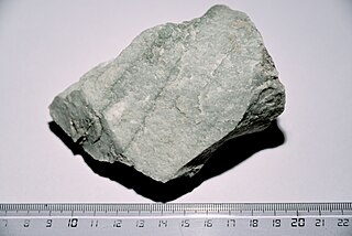
Quartzite is a hard, non-foliated metamorphic rock which was originally pure quartz sandstone. Sandstone is converted into quartzite through heating and pressure usually related to tectonic compression within orogenic belts. Pure quartzite is usually white to grey, though quartzites often occur in various shades of pink and red due to varying amounts of iron oxide (Fe2O3). Other colors, such as yellow, green, blue and orange, are due to other minerals.

The Coteau des Prairies is a plateau approximately 200 miles in length and 100 miles in width, rising from the prairie flatlands in eastern South Dakota, southwestern Minnesota, and northwestern Iowa in the United States. The southeast portion of the Coteau comprises one of the distinct regions of Minnesota, known as Buffalo Ridge.

The Sentinel Range is a major mountain range situated northward of Minnesota Glacier and forming the northern half of the Ellsworth Mountains in Antarctica. The range trends NNW-SSE for about 185 km (115 mi) and is 24 to 48 km wide. Many peaks rise over 4,000 m (13,100 ft) and Vinson Massif (4892 m) in the southern part of the range is the highest elevation on the continent.

Fort Ridgely was a United States Army outpost (1853–1867) near the Dakota reservation in southwestern Minnesota. Built between 1853–1854, it was named for three officers named Ridgely who were killed in the Mexican–American War. The fort played an important role in the Dakota War of 1862. The Battle of Fort Ridgely was fought there in two engagements over August 20–22, 1862 between Army volunteers and refugees from the Minnesota River valley, and Dakota forces.

Buffalo River State Park is a state park of Minnesota, United States, conserving a prairie bisected by the wooded banks of the Buffalo River. Together with the adjacent Bluestem Prairie Scientific and Natural Area owned by The Nature Conservancy, it protects one of the largest and highest-quality prairie remnants in Minnesota. With the closest swimming lake to the Fargo–Moorhead metropolitan area, however, it is most popular for swimming and picnicking. The 1,068-acre (432 ha) park is located just off U.S. Route 10 in Clay County, 4.5 miles (7.2 km) east of Glyndon and 14 miles (23 km) east of Moorhead.

Fort Ridgely State Park is a state park of Minnesota, USA, on the Minnesota River south of Fairfax. It preserves Fort Ridgely, site of the Battle of Fort Ridgely during the Dakota War of 1862. It is the only Minnesota state park with a 9-hole golf course, which overlooks the Minnesota River and goes along Fort Ridgely Creek.
The 23rd Air Division is an inactive United States Air Force intermediate echelon command and control organization. It was last assigned to First Air Force, Tactical Air Command (ADTAC). It was inactivated on 1 July 1987 at Tyndall Air Force Base, Florida.

Buffalo Ridge is a large expanse of rolling hills in the southeastern part of the larger Coteau des Prairies. It stands 1,995 feet (608 m) above sea level. The Buffalo Ridge is sixty miles long and runs through Lincoln County, Pipestone County, Murray County, Nobles County, and Rock County in the southwest corner of Minnesota.

The Dakota War of 1862, also known as the Sioux Uprising, the Dakota Uprising, the Sioux Outbreak of 1862, the Dakota Conflict, the U.S.–Dakota War of 1862 or Little Crow's War, was an armed conflict between the United States and several bands of Dakota. It began on August 17, 1862, along the Minnesota River in southwest Minnesota, four years after its admission as a state. Throughout the late 1850s in the lead-up to the war, treaty violations by the United States and late or unfair annuity payments by Indian agents caused increasing hunger and hardship among the Dakota. During the war, the Dakota made extensive attacks on hundreds of settlers and immigrants, which resulted in settler deaths, and caused many to flee the area. Intense desire for immediate revenge ended with soldiers capturing hundreds of Dakota men and interning their families. A military tribunal quickly tried the men, sentencing 303 to death for their crimes. President Lincoln would later commute the sentence of 264 of them. The mass hanging of 38 Dakota men was conducted on December 26, 1862, in Mankato, Minnesota; it was the largest mass execution in United States history.
Culver is an unincorporated community in Saint Louis County, Minnesota, United States.
Jacobel Glacier is a glacier about 30 miles (50 km) long draining to the Sulzberger Ice Shelf, Antarctica, south of Hershey Ridge. It was named by the Advisory Committee on Antarctic Names after Robert W. Jacobel, holder of the Grace A. Whittier Chair of Physics at St. Olaf College, Northfield, Minnesota. An Antarctic researcher from the 1980s onwards, his research interests include the combination of ground-based radar and ice core studies in West Antarctica.

This is a list of the National Register of Historic Places listings in Nicollet County, Minnesota. It is intended to be a complete list of the properties and districts on the National Register of Historic Places in Nicollet County, Minnesota, United States. The locations of National Register properties and districts for which the latitude and longitude coordinates are included below, may be seen in an online map.

At the end of 2016, the installed capacity for wind power in Minnesota was 3,500 megawatts (MW). Wind power generated nearly 18 percent of Minnesota’s electricity in 2016, ranking sixth in the nation for wind energy as a share of total electricity generation.
The Great River Ridge State Trail is a multi-use recreational rail trail in southeastern Minnesota, United States. It is planned to run 15 miles (24 km) from the city of Plainview through Elgin to Eyota. Currently the final 2 miles (3.2 km) leading into Eyota are incomplete, but the rest of the route is paved and, south of Elgin, includes a parallel unpaved trackway for horseback riders and snowmobiles. An extension providing access to Carley State Park is also planned.
Oakridge is an unincorporated community in Mount Vernon Township, Winona County, Minnesota, United States.


