Saltburn Viaduct

Last updated

Saltburn Viaduct
Viaduct with 11 arches near Skelton - geograph.org.uk - 250969.jpg
Saltburn Viaduct
Coordinates 54°34′20″N0°58′44″W / 54.5721°N 0.9789°W / 54.5721; -0.9789
OS grid reference NZ660201
CarriesBoulby line
Crosses Skelton Beck
Locale Saltburn-by-the-Sea, North Yorkshire, England
Other name(s)See text
Characteristics
MaterialBrick and stone
Total length783 feet (239 m)
Height156 feet (48 m)
No. of spans11
Piers in water2
Rail characteristics
No. of tracks 1 (historically two)
History
Opened1 June 1872
Location
Saltburn Viaduct
References
[1]

Saltburn Viaduct (also known as either Upleatham, Riftswood, or Skelton Beck Viaduct) is a railway bridge in Redcar and Cleveland, North Yorkshire, England. The line was built as an extension of the Redcar and Saltburn Railway, and the viaduct is mostly built out of brick. The line opened to passengers in 1872, but became freight only in 1957, a purpose for which it still is in use for today as part of the Boulby line.

Contents

History

Saltburn Viaduct is believed to have been designed by Thomas Elliot Harrison who was the company architect for the North Eastern Railway between 1854 and 1888. [2] The viaduct is the model for the later built (and longer) Larpool Viaduct in Whitby, however, it was found necessary to deviate from the original plan of Saltburn Viaduct when building the one over the River Esk. [3] The Saltburn Extension line, which connected the railway west of Saltburn to Brotton via North Skelton, was authorised in 1865 as part of the amalgamation of the Cleveland Railway into the North Eastern Railway. [4]

Skelton Beck Viaduct Skelton beck viaduct, Saltburn.jpg
Skelton Beck Viaduct

The viaduct is made mostly from brick, and is the only brick-surviving viaduct in the Cleveland region, others being of stone, or metal, though most have been demolished. [5] [note 1] However the footings of the viaduct's piers are made from ashlar, and the viaduct rises to a height of 156 feet (48 m), with ten piers and eleven arches, with each arch being 60-foot (18 m) in their span. [1] Two of the piers are set into the bed of Skelton Beck, and the viaduct extends for 738 feet (225 m) in length on a north/south axis. [note 2] [10] [11] One writer described the build of the viaduct as being costly and difficult to construct. [12]

The viaduct carries a freight-only railway line (to Skinningrove Steelworks and Boulby Mine) above Millfield Meadow and Skelton Beck, with the long-distance path the Cleveland Way also passing beneath the viaduct on the north bank of Skelton Beck. [8] [13] [14] [15] When opened, the viaduct had two lines, but the line was singled in 1969, eighteen years after the local passenger service to Brotton from Saltburn had ceased, [note 3] [17] [18] [19] and twelve years since long-distance Scarborough to Middlesbrough passenger trains were diverted away from the line. [20]

It is sometimes referred to as either Upleatham Viaduct, or Skelton Beck Viaduct. [21] [22] [23] Locally it is also known as Riftswood (or Rifts Wood) Viaduct, as the area it spans is called Rifts Wood. [24] [25] It has also been referred to locally as Marske Mill Viaduct, as it overlooked Marske Mill to the north (a corn mill on Skelton Beck). [26] The viaduct marks the western boundary of the Saltburn Conservation Area, and the viaduct was grade II listed in May 1999. [27] [10]

In 2006, £446,000 (equivalent to £687,000in 2021) was spent on refurbishing the viaduct because of water ingress in some of the bricks. Repairs could not effected using modern engineering bricks as this would have created "hard spots within the structure and the potential for cracking at the interface between old and new...". A suitable brick was found from a brickworks in Birtley, Tyne and Wear. [1]

See also

Notes

  1. A survey of the mill below the viaduct along the Skelton Beck determined that Mill Farm building had a distinctive "railway architecture" and was possibly where the supervisor of the works was housed during the viaduct's building stage. [6]
  2. The length of the viaduct is subject to some dispute; TRACKmaps Eastern has different lengths between publishing the third and fifth editions (17 chains (1,100 ft; 340 m) and 15 chains (990 ft; 300 m) respectively) of the Eastern Region diagrams, and railway codes has it at a length of 17 chains (1,100 ft; 340 m). [7] [8] [9]
  3. Passenger services to Loftus continued until 1960, but from Middlesbrough via Guisborough. [16]

Related Research Articles

<span class="mw-page-title-main">North Riding of Yorkshire</span> Third of a historic county in England

The North Riding of Yorkshire was a subdivision of Yorkshire, England, alongside York, the East Riding and West Riding. The riding's highest point was at Mickle Fell at 2,585 ft (788 m).

<span class="mw-page-title-main">Tees Valley</span> Devolved region in Northern England

The Tees Valley is a devolved region in Northern England, around the lower River Tees. The area is not a geographical valley; the local term for the valley is Teesdale. The combined authority covers five council areas: Darlington, Hartlepool, Middlesbrough, Redcar and Cleveland and Stockton-on-Tees.

<span class="mw-page-title-main">Saltburn-by-the-Sea</span> Town in North Yorkshire, England

Saltburn-by-the-Sea, commonly referred to as Saltburn, is a seaside town in North Yorkshire, England, 12 miles (19 km) south-east of Hartlepool and 5 miles (8 km) south-east of Redcar. It lies within the historic boundaries of the North Riding of Yorkshire. It had a population of 5,958 in 2011.

<span class="mw-page-title-main">Loftus, North Yorkshire</span> Town and civil parish in North Yorkshire, England

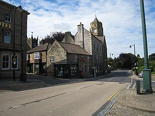
Loftus is a market town and civil parish in the Redcar and Cleveland borough of North Yorkshire, England. The town is located north of the North York Moors and sits between Whitby and Skelton-in-Cleveland.

<span class="mw-page-title-main">Tees Valley line</span> Railway route, in Northern England

The Tees Valley Line is a rail route, in Northern England, following part of the original Stockton and Darlington Railway route of 1825. The line covers a distance of 38 miles (61 km), and connects Bishop Auckland to Saltburn via Darlington, Middlesbrough and 14 other stations in the Teesdale.

<span class="mw-page-title-main">Saltburn, Marske and New Marske</span> Civil parish in North Yorkshire, England

Saltburn, Marske and New Marske is a civil parish in the Redcar and Cleveland district, in the ceremonial county of North Yorkshire, England. According to the 2001 census it had a population of 18,325 increasing to 19,134 at the 2011 census. As its name suggests, the parish includes Saltburn, Marske-by-the-Sea and New Marske. It borders the parishes of Skelton and Brotton, Guisborough and the unparished area of Redcar.

<span class="mw-page-title-main">Saltburn railway station</span> Railway station in North Yorkshire, England

Saltburn is a railway station on the Tees Valley Line, which runs between Bishop Auckland and Saltburn via Darlington. The station, situated 12 miles 57 chains (20.5 km) east of Middlesbrough, serves the seaside town of Saltburn-by-the-Sea, North Yorkshire, England. It is owned by Network Rail and managed by Northern Trains.

<span class="mw-page-title-main">Boulby</span> Village in North Yorkshire, England

Boulby is a hamlet in the Loftus parish, located within the North York Moors National Park. It is in the borough of Redcar and Cleveland, North Yorkshire, England. The hamlet is located off the A174, near Easington and 1-mile (1.6 km) west of Staithes.

<span class="mw-page-title-main">North Skelton</span> Village in Redcar and Cleveland, England

North Skelton is a village in Redcar and Cleveland, North Yorkshire, England.

<span class="mw-page-title-main">Lockwood, North Yorkshire</span> Civil parish in North Yorkshire, England

Lockwood is a civil parish in the unitary authority of Redcar and Cleveland with ceremonial association with North Yorkshire, England. The population of Lockwood ward in the Redcar and Cleveland Unitary authority taken at the 2011 census was 2,022.

<span class="mw-page-title-main">Whitby, Redcar and Middlesbrough Union Railway</span> Former railway line in Yorkshire, England

The Whitby, Redcar and Middlesbrough Union Railway (WRMU), a.k.a. the Whitby–Loftus Line, was a railway line in North Yorkshire, England, built between 1871 and 1886, running from Loftus on the Yorkshire coast to the Esk at Whitby, and connecting Middlesbrough to Whitby along the coast.

<span class="mw-page-title-main">Staithes railway station</span> Former railway station in the North Riding of Yorkshire, England

Staithes railway station was a railway station on the Whitby Redcar and Middlesbrough Union Railway, serving the villages of Staithes and Dalehouse in North Yorkshire, England. It was opened on 3 December 1883.

The Cleveland Railway was a railway line in north-east England running from Normanby Jetty on the River Tees, near Middlesbrough, via Normanby and then via Guisborough through the Eston Hills, to Loftus in East Cleveland. It carried minerals from numerous iron ore mines along its route to the River Tees for shipment to Tyneside and elsewhere. The line was jointly proposed by the West Hartlepool Harbour and Railway (WHH&R), who provided half its capital, together with various landowners. The WHH&R lay on the north bank of the Tees, to which it had a cross-river connection via a jetty at Normanby.

<span class="mw-page-title-main">Loftus railway station</span> Former railway station in the North Riding of Yorkshire, England

Loftus, previously Lofthouse, was a railway station on the Whitby, Redcar and Middlesbrough Union Railway. It was opened on 1 April 1875 as the terminus of a line from Saltburn, and served the town of Loftus. When the line to Whitby was opened on 3 December 1883, it became a through station with two platforms and a goods yard consisting of three sidings. It closed to passenger traffic on 2 May 1960 and goods traffic on 12 August 1963; the tracks through the station were lifted in 1964.

<span class="mw-page-title-main">Boosbeck railway station</span> Disused railway station in North Yorkshire, England

Boosbeck railway station was a railway station serving the village of Boosbeck in the ceremonial county of the North Riding of Yorkshire in England. The station was opened in 1878 and closed to passengers in 1960 with freight services being stopped in 1964.

<span class="mw-page-title-main">Staithes Viaduct</span> Former railway viaduct in North Yorkshire, England

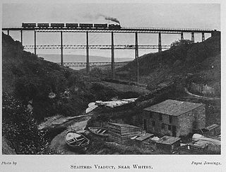
Staithes Viaduct was a railway bridge that straddled Staithes Beck at Staithes, Yorkshire, England. It was north of the closed Staithes railway station. It was known for an anemometer, a fitting to tell the signaller if winds across the viaduct were too strong for crossing trains.

<span class="mw-page-title-main">Kilton Viaduct</span> Viaduct in Yorkshire, England

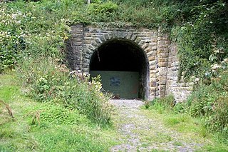
Kilton Viaduct was a railway viaduct that straddled Kilton Beck, near to Loftus, in North Yorkshire, England. The viaduct was opened to traffic in 1867, however in 1911, with the viaduct suffering subsidence from the nearby ironstone mining, the whole structure was encased in waste material from the mines creating an embankment which re-opened fully to traffic in 1913. The railway closed in 1963, but then in 1974, it re-opened as part of the freight line to Boulby Mine carrying potash traffic.

<span class="mw-page-title-main">Slapewath</span> Hamlet in Redcar and Cleveland, England

Slapewath is a hamlet in the borough of Redcar and Cleveland and the ceremonial county of North Yorkshire, England. Whilst the name of the hamlet is recorded as far back as the 13th century, it was developed due to the alum and ironstone industries of the North-Eastern part of Yorkshire in the 16th and 19th centuries respectively. The hamlet lies on the A171 road.

<span class="mw-page-title-main">Boulby line</span> Railway in North-East England

The Boulby line is a freight-only railway line in Redcar and Cleveland, England. The line was opened in stages between 1865 and 1882, being part of two railways that met at Brotton railway station. Passenger trains along the line ceased in 1960, and since then it has been a freight-only line dedicated to the potash and polyhalite traffic from Boulby, and steel products into Skinningrove Steelworks.

References

  1. 1 2 3 Bickerdike, Graeme (9 October 2013). "Turning back time". Rail Engineer. Retrieved 14 January 2024.
  2. Tomlinson, William Weaver (1915). The North Eastern Railway; its rise and development. Newcastle-upon-Tyne: Reid. p. 772. OCLC   8890833.
  3. Fox, F. (January 1886). "Viaduct over the River Esk at Whitby and Culverts in the ravines". Minutes of the Proceedings of the Institution of Civil Engineers. 86 (1886): 303. doi:10.1680/imotp.1886.21174.
  4. Bairstow 2008, p. 31.
  5. Murphy, Richard. "Richard Murphy recounts his lone quest to protect Slapewath Viaduct: Getting a structure listed". forgottenrelics.org. Retrieved 13 January 2024.
  6. Sherlock, Stephen J. (1989). Excavation and survey at Marske Mill, Saltburn. Middlesbrough: Cleveland County Archaeology Section. p. 24, 28. ISBN   0-904-784-19-3.
  7. Yonge, John (2006). Railway track diagrams 2: Eastern (3 ed.). Bradford on Avon: TRACKmaps. 51. ISBN   0-9549866-2-8.
  8. 1 2 Kelman, Leanne (2020). Railway Track Diagrams Book 2: Eastern (5 ed.). Frome: Trackmaps. 48. ISBN   978-1-9996271-3-3.
  9. "Railway viaducts, location Q-S". railwaycodes.org.uk. Retrieved 14 January 2024.
  10. 1 2 Historic England. "Railway viaduct (that part in Skelton and Brotton) (Grade II) (1387286)". National Heritage List for England . Retrieved 14 January 2024.
  11. Tomlinson, William Weaver (1915). The North Eastern Railway; its rise and development. Newcastle-upon-Tyne: Reid. p. 660. OCLC   8890833.
  12. Bowes, Ida (1948). Cleveland and Tees-Side. A geographical study of population and occupational changes since 1800. London: Bedford College (University of London). p. 109. ISBN   978-1-339-61283-6. The early Redcar line was extended to the new watering place of Saltburn in 1861, and eleven years later a large viaduct, at tremendous cost and difficulty, was erected over the deep ravine of Riftswood, through which the Skelton beck reaches the sea, which separates that part of the coast from the Skelton and Brotton uplands.
  13. "Mill Field Meadow". saltburnvalleys.org.uk. Retrieved 14 January 2024.
  14. "306" (Map). Middlesbrough & Hartlepool. 1:25,000. Explorer. Ordnance Survey. 2015. ISBN   978-0-319-24558-3.
  15. Robson, Dave (13 May 2013). "Historic viaduct: Plans to give facelift to Grade II-listed Saltburn structure". Teesside Live. Retrieved 14 January 2024.
  16. Bairstow 2008, p. 111.
  17. Bairstow 2008, p. 97.
  18. Hoole, K. (1971). Railways in Cleveland. Clapham: Dalesman Publishing. p. 62. ISBN   0-85206-131-5.
  19. Chapman, Stephen (2007). Railway Memories No. 18; Cleveland & Whitby. Todmorden: Bellcode Books. p. 79. ISBN   9781871233186.
  20. "Disused Stations: Brotton Station". disused-stations.org.uk. Retrieved 12 February 2024.
  21. Bairstow 2008, pp. 29, 32.
  22. "Disused Stations: Skinningrove Station". disused-stations.org.uk. Retrieved 17 January 2024.
  23. Suggitt, Gordon (2005). Lost railways of North and East Yorkshire. Newbury: Countryside Books. p. 68. ISBN   978-1-85306-918-5.
  24. Lunn, Cath; Lunn, Tony (2006). Saltburn-by-the-Sea Revisited. Stroud: Tempus. p. 56. ISBN   0-7524-3773-9.
  25. "Rifts Wood". saltburnvalleys.org.uk. Retrieved 16 January 2024.
  26. Sherlock, Stephen J. (1989). Excavation and survey at Marske Mill, Saltburn. Middlesbrough: Cleveland County Archaeology Section. p. 27. ISBN   0-904-784-19-3.
  27. "Saltburn Conservation Area Appraisal 2019" (PDF). redcar-cleveland.gov.uk. 2019. p. 49. Retrieved 16 January 2024.

Sources