Dyfed is a preserved county in southwestern Wales. It is a mostly rural area with a coastline on the Irish Sea and the Bristol Channel.

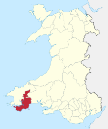
Pembrokeshire is a county in the south-west of Wales. It is bordered by Carmarthenshire to the east, Ceredigion to the northeast, and the rest by sea. The county is home to Pembrokeshire Coast National Park. The Park occupies more than a third of the area of the county and includes the Preseli Hills in the north as well as the 190-mile (310 km) Pembrokeshire Coast Path.

Haverfordwest is the county town of Pembrokeshire, Wales, and the most populous urban area in Pembrokeshire with a population of 14,596 in 2011. It is also a community, being the second most populous community in the county, with 12,042 people, after Milford Haven. The suburbs include the former parish of Prendergast, Albert Town and the residential and industrial areas of Withybush.

Pembroke is both a town and a community in Pembrokeshire, Wales, with a population of 7,552. The names of both the town and the county have a common origin; both are derived from the Cantref of Penfro: Pen, "head" or "end", and bro, "region", "country", "land", which has been interpreted to mean either "Land's End" or "headland".

Tenby is both a walled seaside town in Pembrokeshire, Wales, on the western side of Carmarthen Bay, and a local government community.

Pembroke Dock is a town and a community in Pembrokeshire, South West Wales, 3 miles (4.8 km) northwest of Pembroke on the banks of the River Cleddau. Originally Paterchurch, a small fishing village, Pembroke Dock town expanded rapidly following the construction of the Royal Navy Dockyard in 1814. The Cleddau Bridge links Pembroke Dock with Neyland.

Neyland is a town and community in Pembrokeshire, Wales, lying on the River Cleddau and the upstream end of the Milford Haven estuary. The Cleddau Bridge carrying the A477 links Pembroke Dock with Neyland.

Narberth is both a town and a community in Pembrokeshire, Wales. It was founded around a Welsh court and later became a Norman stronghold on the Landsker Line. It became the headquarters of the hundred of Narberth. It was once a marcher borough. George Owen described it in 1603 as one of nine Pembrokeshire "boroughs in decay".

Dinefwr was one of six local government districts of the county of Dyfed, Wales from 1974 to 1996. It was named after Dinefwr Castle which in the middle ages had been the court of the House of Dinefwr and one of the three principal royal courts of Wales with Aberffraw and Shrewsbury.

Preseli Pembrokeshire was one of six local government districts of Dyfed in West Wales from 1974 to 1996. Until 1987 the name of the district was Preseli. The district took its name from the Preseli Hills.

Carmarthen West and South Pembrokeshire is a constituency of the Senedd. It elects one Member of the Senedd by the first past the post method of election. In addition, it is one of eight constituencies in the Mid and West Wales electoral region, which elects four additional members, in addition to eight constituency members, to produce a degree of proportional representation for the region as a whole.

The first Pembrokeshire County Council was established in 1889 under the Local Government Act 1888, to govern the administrative county of Pembrokeshire. This first county council was abolished in 1974 under the Local Government Act 1972.
Ceredigion District Council was one of six district-level authorities in the county of Dyfed, Wales, from 1974 until 1996. The district had an identical area to the pre-1974 administrative county of Cardiganshire. From its creation in 1974 the district used the name "Ceredigion" rather than "Cardiganshire", which had been used for the former county council. Further local government reorganisation in 1996 saw Dyfed County Council abolished and Ceredigion become a unitary authority, with the district council taking over county-level services to become Ceredigion County Council.
The second election to Dyfed County Council was held in May 1981. It was preceded by the 1977 election and followed by the 1985 election. There were a number of unopposed returns, particularly in rural parts of the county.

Pembroke Dock Llanion was the name of a county electoral ward in the town of Pembroke Dock, Pembrokeshire, Wales. Llanion remains as a ward for elections to Pembroke Dock Town Council.

Pembroke Town Hall is a municipal building in Main Street, Pembroke, Pembrokeshire, Wales. The structure, which is the meeting place of Pembroke Town Council, is a Grade II listed building.
Haverfordwest Rural District was a rural district in the administrative county of Pembrokeshire, Wales from 1894 to 1974, covering an area in the west of the county. It surrounded, but did not include, the town of Haverfordwest after which it was named.
Pembroke Rural District was a rural district in the administrative county of Pembrokeshire, Wales from 1894 to 1974, covering an area in the south of the county. It surrounded, but did not include, the town of Pembroke after which it was named.
Narberth Rural District was a rural district in the administrative county of Pembrokeshire, Wales from 1894 to 1974, covering an area in the east of the county.

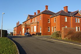
The County Hall is a municipal building on Freemens Way in Haverfordwest, Pembrokeshire, Wales. It was built in 1999 and serves as the offices and meeting place of Pembrokeshire County Council.