Spanish Lake, Missouri

Last updated

Spanish Lake, Missouri
St. Louis County Missouri Incorporated and Unincorporated areas Spanish Lake Highlighted.svg
Location of Spanish Lake, Missouri
Coordinates: 38°47′18″N90°12′28″W / 38.78833°N 90.20778°W / 38.78833; -90.20778
Country United States
State Missouri
County St. Louis
Area
[1]
  Total7.49 sq mi (19.39 km2)
  Land7.37 sq mi (19.09 km2)
  Water0.11 sq mi (0.29 km2)
Elevation
[2]
512 ft (156 m)
Population
 (2020)
  Total18,413
  Density2,497.69/sq mi (964.34/km2)
Time zone UTC-6 (Central (CST))
  Summer (DST) UTC-5 (CDT)
FIPS code 29-69266 [3]
GNIS feature ID2393243 [2]

Spanish Lake is a census-designated place (CDP) in St. Louis County, Missouri, United States. The population was 18,413 at the 2020 census. [4]

Contents

Geography

The Spanish Lake community is located in the northeastern portion of St. Louis County. The community is bounded by the Mississippi River to the east, the Missouri River to the north, Highway 367 to the west, and Interstate 270 to the south. [5]

According to the United States Census Bureau, the CDP has a total area of 7.5 square miles (19 km2), of which 7.4 square miles (19 km2) is land and 0.2 square miles (0.52 km2), or 2.13%, is water.

History

Spanish Lake, originally called Spanish Pond until the late nineteenth century, was named after the Spanish troops who stayed there while building a fortified post for Spain in 1768. Much of the area was once the property of James De St. Vrain, a brother of the last Spanish lieutenant governor of Upper Louisiana. It was in this district, near Spanish Pond, that an old log cabin, said to have been used as a government building by Lieutenant Governor De Lassus De St. Vrain, the last Spanish executive to rule this section, was erected. [5]

Spanish Lake prospered in the nineteenth century, as a crossroads farming village came into being. The Bellefontaine Road area was settled largely after General Bissell relocated Fort Bellefontaine. Fort Bellefontaine was established in 1806 by Gen. James Wilkerson, governor of the territory of Louisiana. The fort served as one of the most important military posts west of the Mississippi River until the troops were removed to the Jefferson Barracks reservation in 1827. Traffic between St. Louis and the fort was busy; many officials had homes in both places, and visiting dignitaries usually went to both sites. The liveliest traffic was effected by the farmers riding back and forth to the city. [5]

Spanish Lake became a well-developed neighborhood with the arrival of German immigrants. Farmland was intensely cultivated, and small businesses and industries sprang up around the intersection of Bellefontaine, Parker, and Spanish Pond roads, forming the village's center. The Catholic parish of St. Aloysius in Spanish Lake was founded by, and for many years served as, a mission of Baden, located in the northern portion of St. Louis. The Bank of Baden played a large role in farm financing in Spanish Lake, and many county farmers also had business interests in Baden. The German dominance of the region was almost complete by the 1870s, and most of the surviving farm houses and outbuildings are associated with that era. [5]

Spanish Lake was a rural farming community for many years, until the 1950s when neighborhoods of tract housing were built. The area became a rural refuge from St. Louis city and received an exclusively white population. The 1970s saw the proliferation of dense apartment housing to Spanish Lake. African-Americans fleeing the failed Pruitt-Igoe public housing high rises in the city moved into the apartments via the Section 8 voucher system which immediately struck racial tensions in the area, particularly in local schools. The 1990s saw a mass exodus of the white population, spurred on by blockbusting, a practice some U.S. real estate agents use to encourage white property owners to sell their houses quickly at a loss, implying the African-Americans moving into their neighborhood will depress their property values. This era of the city's history is chronicled in the documentary Spanish Lake, although its depiction comes with some disagreement from community stakeholders. [6] [ better source needed ]

Demographics

Historical population
CensusPop.Note
1970 15,647
1980 20,63231.9%
1990 20,322−1.5%
2000 21,3375.0%
2010 19,650−7.9%
2020 18,413−6.3%
U.S. Decennial Census [7]
2010 [8] 2020 [9]
Spanish Lake CDP, Missouri – Racial and ethnic composition
Note: the US Census treats Hispanic/Latino as an ethnic category. This table excludes Latinos from the racial categories and assigns them to a separate category. Hispanics/Latinos may be of any race.
Race / Ethnicity (NH = Non-Hispanic)Pop 2010 [8] Pop 2020 [9] % 2010% 2020
White alone (NH)3,8082,10719.38%11.44%
Black or African American alone (NH)15,04515,14576.56%82.25%
Native American or Alaska Native alone (NH)38630.19%0.34%
Asian alone (NH)75560.38%0.30%
Pacific Islander alone (NH)410.02%0.01%
Some Other Race alone (NH)241590.12%0.86%
Mixed Race or Multi-Racial (NH)4125502.10%2.99%
Hispanic or Latino (any race)2443321.24%1.80%
Total19,65018,413100.00%100.00%

2000 Census

As of the census [3] of 2000, there were 21,337 people, 8,381 households, and 5,673 families residing in the CDP. The population density was 2,900.4 inhabitants per square mile (1,119.9/km2). There were 8,852 housing units at an average density of 1,203.3 per square mile (464.6/km2). The racial makeup of the CDP was 42.25% White, 54.79% African American, 0.20% Native American, 0.66% Asian, 0.03% Pacific Islander, 0.46% from other races, and 1.61% from two or more races. Hispanic or Latino of any race were 1.03% of the population.

There were 8,381 households, out of which 38.3% had children under the age of 18 living with them, 39.4% were married couples living together, 23.6% had a female householder with no husband present, and 32.3% were non-families. 27.6% of all households were made up of individuals, and 8.9% had someone living alone who was 65 years of age or older. The average household size was 2.54 and the average family size was 3.09.

In the CDP, the population was spread out, with 30.4% under the age of 18, 9.9% from 18 to 24, 31.3% from 25 to 44, 17.3% from 45 to 64, and 11.0% who were 65 years of age or older. The median age was 31 years. For every 100 females, there were 86.0 males. For every 100 females age 18 and over, there were 79.0 males.

The median income for a household in the CDP was $37,410, and the median income for a family was $44,139. Males had a median income of $32,340 versus $26,644 for females. The per capita income for the CDP was $18,976. About 10.2% of families and 11.7% of the population were below the poverty line, including 18.4% of those under age 18 and 8.0% of those age 65 or over.

Government

The National Archives has a facility in Spanish Lake. [10]

Education

Spanish Lake is in the Hazelwood School District. [11]

Related Research Articles

<span class="mw-page-title-main">Kendall West, Florida</span> Census-designated place in Florida

Kendall West is a census-designated place and unincorporated community in Miami-Dade County, Florida, west of the Florida Turnpike. It is located in the Miami metropolitan area of South Florida. The population was 36,536 at the 2020 census.

<span class="mw-page-title-main">Palm Springs North, Florida</span> Census-designated place in Florida

Palm Springs North is an unincorporated community and census-designated place (CDP) in Miami-Dade County, Florida, United States. It is part of the Miami metropolitan area of South Florida. The population was 5,030 at the 2020 census.

<span class="mw-page-title-main">Sunset, Florida</span> Census-designated place in Florida

Sunset is a census-designated place (CDP) in Miami-Dade County, Florida, United States. It is part of the Miami metropolitan area of South Florida. The population was 15,912 at the 2020 census. The U.S. Postal Service uses the ZIP Codes of 33173 and 33183 for Sunset.

<span class="mw-page-title-main">Westwood Lakes, Florida</span> Census-designated place in Florida

Westwood Lakes is a census-designated place and unincorporated community of Miami-Dade County, Florida, United States. It is part of the Miami metropolitan area of South Florida. The population was 11,373 at the 2020 census.

<span class="mw-page-title-main">Channel Lake, Illinois</span> Census-designated place in Illinois, United States

Channel Lake is an unincorporated community and census-designated place (CDP) in Antioch Township, Lake County, Illinois, United States. Per the 2020 census, the population was 1,581.

Forest Lake is an unincorporated community and census-designated place (CDP) in Ela Township of Lake County, Illinois, United States. It is about 35 miles (56 km) northwest of downtown Chicago. Per the 2020 census, the population was 1,784. The community was founded in 1935 as a vacation community for Chicago residents.

Lake Catherine is an unincorporated community and census-designated place (CDP) in Lake County, Illinois, United States. Per the 2020 census, the population was 1,279.

Long Lake is an unincorporated community and census-designated place (CDP) in Lake County, Illinois, United States. Per the 2020 census, the population was 3,663.

Venetian Village is a census-designated place (CDP) in Lake County, Illinois, United States. Per the 2020 census, the population was 2,761.

<span class="mw-page-title-main">Arnold, Minnesota</span> Census-designated place in Minnesota, US

Arnold is a former census-designated place (CDP), which was located in Rice Lake, Saint Louis County, Minnesota, United States. The population was 2,960 at the 2010 census. The census-designated place of Arnold was located entirely within the former Rice Lake Township, adjacent to the north side of the city of Duluth. Rice Lake Township was incorporated as the city of Rice Lake on October 22, 2015, thus rendering the census-designated place of Arnold to no longer exist.

<span class="mw-page-title-main">Cedar Hill, Missouri</span> Census-designated place in Missouri, United States

Cedar Hill is an unincorporated community and census-designated place (CDP) in northwest Jefferson County, Missouri, United States. The population was 1,721 at the 2010 census.

<span class="mw-page-title-main">Murphy, Missouri</span> Census-designated place in Missouri, United States

Murphy is a census-designated place (CDP) in Jefferson County, Missouri, United States. The population was 8,690 at the 2010 census, down from 9,048 in 2000.

<span class="mw-page-title-main">Bellefontaine Neighbors, Missouri</span> City in Missouri, United States

Bellefontaine Neighbors is an inner-ring suburb city in St. Louis County, Missouri, United States. The population was 10,860 at the 2010 census.

<span class="mw-page-title-main">Crystal Lake Park, Missouri</span> City in Missouri, United States

Crystal Lake Park is a Missouri Class 4 city in St. Louis County, Missouri, United States. The population was 508 at the 2020 census.

<span class="mw-page-title-main">Glasgow Village, Missouri</span> CDP in Missouri, United States

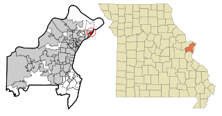
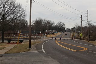
Glasgow Village is a census-designated place (CDP) in St. Louis County, Missouri, United States. The population was 5,429 at the 2010 census.

<span class="mw-page-title-main">Lemay, Missouri</span> CDP in Missouri, United States

Lemay is a census-designated place (CDP) in south St. Louis County, Missouri, United States. The population was 16,645 at the 2010 census.

<span class="mw-page-title-main">Oakville, Missouri</span> CDP in Missouri, United States

Oakville is a census-designated place (CDP) in south St. Louis County, Missouri, United States. The population was 36,301 at the 2020 census. Oakville is 18 miles south of the city of St. Louis and borders the Mississippi and Meramec rivers; the area is part of "South County".

<span class="mw-page-title-main">Castle Point, Missouri</span> Place in Missouri, United States

Castle Point is an unincorporated community and census-designated place (CDP) in St. Louis County, Missouri, United States. The population was 3,962 at the 2010 census.

<span class="mw-page-title-main">Victory Lakes, New Jersey</span> Populated place in Gloucester County, New Jersey, US

Victory Lakes is an unincorporated community and census-designated place (CDP) located within Monroe Township, in Gloucester County, in the U.S. state of New Jersey. As of the 2010 United States Census, the CDP's population was 2,111.

<span class="mw-page-title-main">Cedar Glen Lakes, New Jersey</span> Populated place in Ocean County, New Jersey, US

Cedar Glen Lakes is an unincorporated community and census-designated place (CDP) located within Manchester Township, in Ocean County, in the U.S. state of New Jersey. As of the 2010 United States Census, the CDP's population was 1,421.

References

  1. "ArcGIS REST Services Directory". United States Census Bureau. Retrieved August 28, 2022.
  2. 1 2 U.S. Geological Survey Geographic Names Information System: Spanish Lake, Missouri
  3. 1 2 "U.S. Census website". United States Census Bureau . Retrieved January 31, 2008.
  4. "Spanish Lake CDP, Missouri". United States Census Bureau . Retrieved September 17, 2022.
  5. 1 2 3 4 http://www.stlouisco.com/plan/Comp-Plans/Span-Lake/pages4to10.pdf St. Louis County, Missouri website
  6. Spanish Lake Community Association
  7. "Decennial Census by Decade". US Census Bureau.
  8. 1 2 "P2 Hispanic or Latino, and Not Hispanic or Latino by Race – 2010: DEC Redistricting Data (PL 94-171) - Spanish Lake CDP, Missouri". United States Census Bureau .
  9. 1 2 "P2 Hispanic or Latino, and Not Hispanic or Latino by Race – 2020: DEC Redistricting Data (PL 94-171) - Spanish Lake CDP, Missouri". United States Census Bureau .
  10. "National Archives at St. Louis". National Archives . Retrieved August 7, 2022. 1 Archives Drive, St. Louis, MO 63138 - The address is not in the St. Louis city limits but is in the Spanish Lake CDP
  11. "2020 CENSUS - SCHOOL DISTRICT REFERENCE MAP: St. Louis County, MO" (PDF). U.S. Census Bureau. Archived (PDF) from the original on July 22, 2022. Retrieved July 22, 2022. - Text list