Starbuck, Minnesota

Last updated

Starbuck, Minnesota
Starbuck MN.JPG
Starbuck, Minnesota
Pope County Minnesota Incorporated and Unincorporated areas Starbuck Highlighted.svg
Location of Starbuck, Minnesota
Coordinates: 45°36′42″N95°31′56″W / 45.61167°N 95.53222°W / 45.61167; -95.53222
CountryUnited States
State Minnesota
County Pope
PlattedSpring of 1882
Incorporated June 6, 1883
Government
   Mayor Gary E. Swenson
Area
[1]
  Total1.480 sq mi (3.833 km2)
  Land1.480 sq mi (3.833 km2)
  Water0.000 sq mi (0.000 km2)
Elevation
[2]
1,165 ft (355 m)
Population
 (2020) [3]
  Total1,365
  Estimate 
(2022) [4]
1,410
  Density922.30/sq mi (356.12/km2)
Time zone UTC–6 (Central (CST))
  Summer (DST) UTC–5 (CDT)
ZIP Code
56381
Area code 320
FIPS code 27-62500
GNIS feature ID2395956 [2]
Sales tax 6.875% [5]
Website starbuckcitygov.com

Starbuck is a city in Pope County, Minnesota, United States. The population was 1,365 at the 2020 census. [3] The city is on the western shore of Lake Minnewaska.

Contents

Geography

Minnesota State Highways 28, 29, and 114 are three of Starbuck's main routes.

According to the United States Census Bureau, the city has an area of 1.48 square miles (3.83 km2), all land. [1]

History

The 1882 Little Falls and Dakota Depot is now used as a museum and listed on the National Register of Historic Places Starbuck Depot.jpg
The 1882 Little Falls and Dakota Depot is now used as a museum and listed on the National Register of Historic Places

Starbuck was platted in the spring of 1882, as a village on the Northern Pacific railway, adjoining Lake Minnewaska. The growth and settlement of Pope County were greatly impeded for many years by the lack of railway and shipping facilities, which obliged settlers to go long distances into adjoining counties to market their products. [6]

The town was reportedly named after Stabekk in Bærum in Akershus county, Norway. But Geographical Names of Manitoba [7] says the village of Starbuck, Manitoba, is thought to have been named after the town in Minnesota by a contractor working for the Canadian Pacific Railway in 1885, and that Starbuck, Minnesota, was named after William H. Starbuck of New York, who financed the Little Falls and Dakota Railroad. [8] Some also believe the town's name comes from the oxen used to build the railroad through the town, whose names were Star and Buck.[ citation needed ]

Demographics

Historical population
CensusPop.Note
1890 224
1900 469109.4%
1910 4976.0%
1920 82465.8%
1930 781−5.2%
1940 97224.5%
1950 1,14317.6%
1960 1,099−3.8%
1970 1,1383.5%
1980 1,2247.6%
1990 1,143−6.6%
2000 1,31415.0%
2010 1,302−0.9%
2020 1,3654.8%
2022 (est.)1,410 [4] 3.3%
U.S. Decennial Census [9]
2020 Census [3]

2010 census

As of the 2010 census, there were 1,302 people, 576 households, and 328 families living in the city. The population density was 829.3 inhabitants per square mile (320.2/km2). There were 671 housing units at an average density of 427.4 per square mile (165.0/km2). The racial makeup of the city was 97.3% White, 0.3% African American, 0.3% Native American, 0.8% from other races, and 1.3% from two or more races. Hispanic or Latino people of any race were 1.3% of the population.

There were 576 households, of which 22.9% had children under the age of 18 living with them, 42.5% were married couples living together, 9.9% had a female householder with no husband present, 4.5% had a male householder with no wife present, and 43.1% were non-families. 36.5% of all households were made up of individuals, and 19.5% had someone living alone who was 65 years of age or older. The average household size was 2.14 and the average family size was 2.75.

The median age in the city was 45.8 years. 19.9% of residents were under the age of 18; 8.4% were between the ages of 18 and 24; 21% were from 25 to 44; 25% were from 45 to 64; and 25.8% were 65 years of age or older. The gender makeup of the city was 48.8% male and 51.2% female.

2000 census

As of the 2000 census, there were 1,314 people, 565 households, and 328 families living in the city. The population density was 834.0 inhabitants per square mile (322.0/km2). There were 633 housing units at an average density of 401.8 per square mile (155.1/km2). The racial makeup of the city was 99.01% White, 0.23% from other races, and 0.76% from two or more races. Hispanic or Latino people of any race were 0.46% of the population.

There were 565 households, of which 26.5% had children under the age of 18 living with them, 47.8% were married couples living together, 7.6% had a female householder with no husband present, and 41.9% were non-families. 38.8% of all households were made up of individuals, and 25.8% had someone living alone who was 65 years of age or older. The average household size was 2.16 and the average family size was 2.84.

In the city, the population was spread out, with 22.0% under the age of 18, 4.9% from 18 to 24, 23.1% from 25 to 44, 19.2% from 45 to 64, and 30.9% who were 65 years of age or older. The median age was 45. For every 100 females, there were 82.0 males. For every 100 females 18 and over, there were 76.7 males.

The median income for a household in the city was $28,235, and the median income for a family was $40,875. Males had a median income of $30,865 versus $21,184 for females. The per capita income for the city was $15,030. About 7.9% of families and 13.1% of the population were below the poverty line, including 11.5% of those under age 18 and 23.6% of those age 65 or over.

Related Research Articles

<span class="mw-page-title-main">Pope County, Minnesota</span> County in Minnesota, United States

Pope County is a county in the U.S. state of Minnesota. As of the 2020 census, the population was 11,308. Its county seat is Glenwood. The county was formed in 1862 and organized in 1866.

<span class="mw-page-title-main">Foley, Minnesota</span> City in Minnesota, United States

Foley is a city and the county seat of Benton County, Minnesota, United States. The population was 2,711 at the 2020 census.

<span class="mw-page-title-main">Backus, Minnesota</span> City in Minnesota, United States

Backus is a city in Cass County, Minnesota, United States. The population was 250 at the 2010 census. It is part of the Brainerd Micropolitan Statistical Area.

<span class="mw-page-title-main">Lake Shore, Minnesota</span> City in Minnesota, United States

Lake Shore is a city in Cass County, Minnesota, United States. The population was 1,056 at the 2020 census. It is part of the Brainerd Micropolitan Statistical Area.

<span class="mw-page-title-main">Pillager, Minnesota</span> City in Minnesota, United States

Pillager is a city in Cass County, Minnesota, United States. Its population was 469 at the 2010 census. It is part of the Brainerd Micropolitan Statistical Area.

<span class="mw-page-title-main">Deerwood, Minnesota</span> City in Minnesota, United States

Deerwood is a city in Crow Wing County, Minnesota, United States. The population was 526 at the 2020 census. It is part of the Brainerd Micropolitan Statistical Area.

<span class="mw-page-title-main">Isanti, Minnesota</span> City in the United States

Isanti is a city in Isanti County, Minnesota, United States. The population was 6,804 at the 2020 census. The name Isanti is composed of two Dakota words: isan ("knife") and ati ("camp"), and refers to the Santee Dakota people.
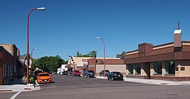
<span class="mw-page-title-main">Cyrus, Minnesota</span> City in Minnesota, [[United States]]

Cyrus is a city in Pope County, Minnesota, United States, along the Chippewa River. The population was 305 at the 2020 census.

<span class="mw-page-title-main">Glenwood, Minnesota</span> City in Minnesota, United States

Glenwood is a city in, and the county seat of, Pope County, Minnesota, United States. The population was 2,657 at the 2020 census. It is located on the northeastern shore of Lake Minnewaska.

<span class="mw-page-title-main">Long Beach, Minnesota</span> City in Minnesota, United States

Long Beach is a city in Pope County, Minnesota, United States. The population was 338 at the 2020 census.

<span class="mw-page-title-main">Lowry, Minnesota</span> City in Minnesota, United States

Lowry is a city in Pope County, Minnesota, United States. The population was 334 at the 2020 census.

Minnewaska Township is a township in Pope County, Minnesota, United States. The population was 504 at the 2000 census.

<span class="mw-page-title-main">Villard, Minnesota</span> City in Minnesota, United States

Villard is a city in Pope County, Minnesota, United States. The population was 225 at the 2020 census.

<span class="mw-page-title-main">Westport, Minnesota</span> City in Minnesota, United States

Westport is a city in Pope County, Minnesota, United States. The population was 44 at the 2020 census.

White Bear Lake Township is a township in Pope County, Minnesota, United States. The population was 440 at the 2000 census.

<span class="mw-page-title-main">McKinley, St. Louis County, Minnesota</span> City in Minnesota, United States

McKinley is a city in Saint Louis County, Minnesota, United States; located within the Iron Range region of Minnesota. The population was 103 at the 2020 census.

<span class="mw-page-title-main">St. Leo, Minnesota</span> City in Minnesota, United States

St. Leo or Saint Leo is a city in Yellow Medicine County, Minnesota, United States. The population was 93 at the 2020 census.

<span class="mw-page-title-main">Minnesota Lake, Minnesota</span> City in Minnesota, United States

Minnesota Lake is a city in Blue Earth and Faribault counties in the State of Minnesota. The population was 661 at the 2020 census. The bulk of the city is in Faribault County; a small part extends into Blue Earth County.

<span class="mw-page-title-main">Brooten, Minnesota</span> City in Minnesota, United States

Brooten is a city in Stearns and Pope counties in the U.S. state of Minnesota, United States. The population was 626 as of the 2020 census. Almost the entire city is within Stearns County, with a small portion in Pope County.

<span class="mw-page-title-main">Chatfield, Minnesota</span> City in Minnesota, United States

Chatfield is a city in Fillmore and Olmsted counties in the U.S. state of Minnesota. The population was 2,779 at the 2010 census. The city's area is split almost equally between the two counties. Chatfield is known as "The Gateway to Bluff Country" and "The Chosen Valley".

References

  1. 1 2 "2023 U.S. Gazetteer Files". United States Census Bureau. Retrieved February 21, 2024.
  2. 1 2 U.S. Geological Survey Geographic Names Information System: Starbuck, Minnesota
  3. 1 2 3 "Explore Census Data". United States Census Bureau . Retrieved February 19, 2024.
  4. 1 2 "City and Town Population Totals: 2020–2022". United States Census Bureau. February 19, 2024. Retrieved February 19, 2024.
  5. "Starbuck (MN) sales tax rate" . Retrieved February 19, 2024.
  6. Pope County History (Pope County Courthouse)
  7. Geographical Names of Manitoba
  8. "Pope County History(from the "Illustrated Album of Biography of Pope and Stevens Counties)". Archived from the original on November 30, 2010. Retrieved September 12, 2010.
  9. "Census of Population and Housing". United States Census Bureau. Retrieved June 4, 2015.