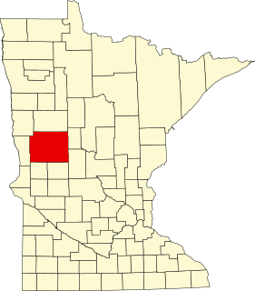
Pope County is a county in the U.S. state of Minnesota. As of the 2010 United States Census, the population was 10,995. Its county seat is Glenwood. The county was formed in 1862 and organized in 1866.

Marine on St. Croix is a city in Washington County, Minnesota, United States. The population was 689 at the 2010 census. It was founded in 1839 as Marine Mills. The city was the site of the first commercial sawmill on the St. Croix River. A substantial portion of the city is listed as a historic district on the National Register of Historic Places and by the state of Minnesota.

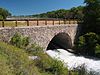
Saint Anthony Falls, or the Falls of Saint Anthony, northeast of downtown Minneapolis, Minnesota, was the only natural major waterfall on the Upper Mississippi River. The natural falls were replaced by a concrete overflow spillway after it partially collapsed in 1869. Later, in the 1950s and 1960s, a series of locks and dams was constructed to extend navigation to points upstream.

Pottersville is an unincorporated community split between Bedminster Township in Somerset County, Tewksbury Township in Hunterdon County and Washington Township in Morris County, New Jersey, United States. The area is served as United States Postal Service ZIP Code 07979. As of the 2010 United States Census, the population for ZIP Code Tabulation Area 07979 was 589. In 1990, most of the village was listed on the National Register of Historic Places as the Pottersville Village Historic District.
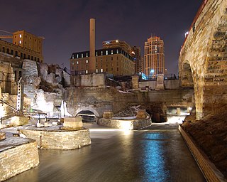
Mill Ruins Park is a park in downtown Minneapolis, Minnesota, United States, standing on the west side of Saint Anthony Falls on the Mississippi River. The park interprets the history of flour milling in Minneapolis and shows the ruins of several flour mills that were abandoned.

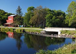
The Marine Mill, established in 1839, was the first commercial sawmill in what became the U.S. state of Minnesota. Now in ruins, it is currently a historic site managed by the city of Marine on St. Croix in partnership with the Minnesota Historical Society. It was listed on the National Register of Historic Places as the Marine Mill Site in 1970 for having state-level significance in the themes of exploration/settlement, industry, and transportation. It was nominated for being the birthplace of the region's seminal industry—lumbering—and a major landing on its crucial transportation route, the St. Croix River. The site is also a contributing property to the Marine on St. Croix Historic District.
This is a list of the National Register of Historic Places listings in Otter Tail County, Minnesota. It is intended to be a complete list of the properties and districts on the National Register of Historic Places in Otter Tail County, Minnesota, United States. The locations of National Register properties and districts for which the latitude and longitude coordinates are included below, may be seen in an online map.

This is a list of the National Register of Historic Places listings in Fillmore County, Minnesota. It is intended to be a complete list of the properties and districts on the National Register of Historic Places in Fillmore County, Minnesota, United States. The locations of National Register properties and districts for which the latitude and longitude coordinates are included below, may be seen in an online map.
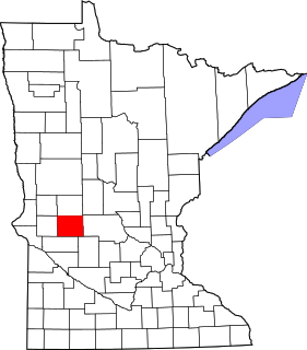
This is a list of the National Register of Historic Places listings in Pope County, Minnesota. It is intended to be a complete list of the properties and districts on the National Register of Historic Places in Pope County, Minnesota, United States. The locations of National Register properties and districts for which the latitude and longitude coordinates are included below, may be seen in an online map.

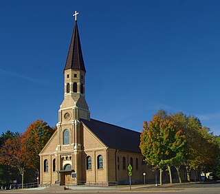
The Church of St. Joseph is a historic Roman Catholic church building in St. Joseph, Minnesota, United States. It is part of the Roman Catholic Diocese of Saint Cloud. It was constructed in a German immigrant community in 1869, though the tower wasn't completed until 1884. A rectory stands east of the church. Both buildings were listed on the National Register of Historic Places in 1982 for their state-level significance in the themes of architecture, exploration/settlement, and religion. The property was nominated for reflecting the settlement of rural Stearns County by Catholic immigrant groups clustered in small, ethnic hamlets dominated by a central church.

St. Mary Help of Christians Church is a historic Roman Catholic church building in St. Augusta, Minnesota, United States. It is part of the Roman Catholic Diocese of Saint Cloud. The church was constructed in 1873 in a rural community settled by German immigrants. An 1890 rectory stands southeast of the church. Both buildings were listed on the National Register of Historic Places in 1982 for their state-level significance in the themes of architecture, exploration/settlement, and religion. The property was nominated for reflecting the settlement of rural Stearns County by Catholic immigrant groups clustered in small, ethnic hamlets dominated by a central church.
The Church of St. Stephen is a historic Roman Catholic church building in St. Stephen, Minnesota, United States. It is part of the Roman Catholic Diocese of Saint Cloud. The church was constructed in 1903 in a rural community settled by Slovene immigrants. An 1890 rectory stands behind the church. Both buildings were listed on the National Register of Historic Places in 1982 for their state-level significance in the themes of architecture, exploration/settlement, and religion. The property was nominated for reflecting the settlement of rural Stearns County by Catholic immigrant groups clustered in small, ethnic hamlets dominated by a central church.

The Church of the Immaculate Conception is a historic Roman Catholic church building in the unincorporated community of St. Anna, Minnesota, United States. It is part of the Roman Catholic Diocese of Saint Cloud. The church was constructed in 1902 in a rural community settled by Polish immigrants. It was listed on the National Register of Historic Places in 1982 for its state-level significance in the themes of architecture, exploration/settlement, and religion. It was nominated for reflecting the settlement of rural Stearns County by Catholic immigrant groups clustered in small, ethnic hamlets dominated by a central church.

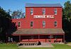
The Terrace Mill is a historic watermill in Terrace, Minnesota, United States, now operated as a museum. Managed by the non-profit Terrace Mill Foundation, the mill contains a gallery, theatre, and gift shop, while the grounds host outdoor events. The mill and four associated structures are listed on the National Register of Historic Places as the Terrace Mill Historic District for having local significance in commerce, engineering, industry, and transportation.

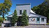
The Little Falls and Dakota Depot, also called the Starbuck Depot, is a former railway station in Starbuck, Minnesota. It was in service from 1882 to 1982. The depot was listed on the National Register of Historic Places in 2006 for having local significance under the themes of commerce, exploration/settlement, and transportation. It was nominated for its associations with the expansion of rail lines and European settlement into the region, and the growth of Starbuck as an agricultural trade center. The depot was restored beginning in 1986 by the non-profit Starbuck Depot Society, and it is now part of an open-air museum.
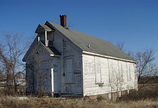
District No. 48 School, later Franklin Township Hall, is a historic one-room school in Franklin Township, Minnesota, United States, built in 1871. It was listed on the National Register of Historic Places in 1979 for having local significance in the themes of architecture and education. It was nominated as an example of the early schoolhouses built throughout rural Wright County in the late 19th century. It is now vacant.

Arcola Mills is a historic house in the unincorporated community of Arcola, Minnesota, United States. Built in 1847, it is considered the third-oldest and largest all-wood-frame house still standing in Minnesota. It was the home of brothers Martin and John Mower, who established one of the first sawmills on the St. Croix River and the community around it. The house and the remnants of the nearby mill were listed on the National Register of Historic Places in 1980 as the John and Martin Mower House and Arcola Mill Site for having local significance in the themes of architecture, exploration/settlement, and industry. The property was nominated as an "excellent example" of Greek Revival architecture and for its association with the region's early settlement and lumber industry. The property now operates as a non-profit event and education center.

The Wabasha Commercial Historic District is a designation applied to the historic downtown of Wabasha, Minnesota, United States. It comprises 52 contributing properties built from 1856 to 1928. It was listed as a historic district on the National Register of Historic Places in 1982 for having local significance in the theme of commerce. It was nominated for the integrity of its cohesive design and its continuity of use as a commercial district since the mid-19th century.

Carver Historic District is a historic district in Carver, Minnesota, United States. It was listed on the National Register of Historic Places in 1980 for having state-level significance in the themes of architecture, commerce, exploration/settlement, industry, and transportation. The district encompasses about 100 contributing properties mostly built from 1855 to 1880. It was nominated for being the well-preserved core of a Minnesota River town, and Carver County's greatest concentration of historically and architecturally significant buildings.

Reads Landing School is a former school building in the unincorporated community of Reads Landing, Minnesota, United States. Built in 1870, it has been converted into the Wabasha County Historical Society Museum. The building is one of the state's oldest surviving brick schools, and typifies their characteristic boxy, bracketed, Italianate style. The school was listed on the National Register of Historic Places in 1989 for having local significance in the themes of architecture and exploration/settlement. It was nominated for being a rare surviving example of Minnesota's early brick schools, and for its association with Reads Landing's peak as a lumber milling boomtown.