Tamayo, Dominican Republic

Last updated
Tamayo
Dominican Republic relief location map.jpg
Red pog.svg
Tamayo
Location in the Dominican Republic
Coordinates: 18°24′N71°12′W / 18.400°N 71.200°W / 18.400; -71.200 Coordinates: 18°24′N71°12′W / 18.400°N 71.200°W / 18.400; -71.200
Country Dominican Republic
Province Baoruco
Municipality1943
Area
[1]
  City455.85 km2 (176.00 sq mi)
Elevation
[2]
10 m (30 ft)
Population
 (2002) [3]
  City23,294
  Density51/km2 (130/sq mi)
   Urban
8,812
   Demonym
Tamayense
Municipal districts 6
Distance to
- Santo Domingo

217 km

Tamayo is a city and a municipality in the Baoruco province of the Dominican Republic. Tamayo is the driest location in the Dominican Republic and the only-one with a desertic climate.

Contents

Geographical context

Tamayo is a small town filled with simple, fascinating people. Belonging to the province Baoruco, it is located on the eastern side of the Neyba valley, in the mountains of western Yaque del Sur River, which separates it from the municipality of Vicente Noble in the province of Barahona, south of San Juan de la Maguana and east of the Galván township.

Climate

Its location over a number of rain shadows through the highlands of Hispaniola from the northeasterly trade winds gives Tamayo a desert climate (Köppen BWh). Rainfall is negligible during most of the year, except between May–June and August–September.

Climate data for Tamayo, Dominican Republic (1961–1990)
MonthJanFebMarAprMayJunJulAugSepOctNovDecYear
Record high °C (°F)37.0
(98.6)
36.0
(96.8)
35.8
(96.4)
36.6
(97.9)
36.2
(97.2)
36.1
(97.0)
39.9
(103.8)
39.5
(103.1)
38.4
(101.1)
38.7
(101.7)
38.2
(100.8)
35.5
(95.9)
39.9
(103.8)
Average high °C (°F)31.0
(87.8)
31.1
(88.0)
31.3
(88.3)
31.5
(88.7)
31.9
(89.4)
32.4
(90.3)
33.3
(91.9)
33.3
(91.9)
33.2
(91.8)
32.8
(91.0)
32.5
(90.5)
31.6
(88.9)
32.2
(90.0)
Daily mean °C (°F)25.2
(77.4)
25.4
(77.7)
25.8
(78.4)
26.5
(79.7)
27.1
(80.8)
27.6
(81.7)
28.1
(82.6)
28.0
(82.4)
28.0
(82.4)
27.7
(81.9)
27.0
(80.6)
25.8
(78.4)
26.9
(80.4)
Average low °C (°F)19.4
(66.9)
19.8
(67.6)
20.4
(68.7)
21.5
(70.7)
22.4
(72.3)
22.8
(73.0)
22.9
(73.2)
22.8
(73.0)
22.9
(73.2)
22.6
(72.7)
21.6
(70.9)
20.0
(68.0)
21.6
(70.9)
Record low °C (°F)13.9
(57.0)
12.6
(54.7)
12.4
(54.3)
15.5
(59.9)
19.0
(66.2)
19.8
(67.6)
19.8
(67.6)
19.8
(67.6)
19.3
(66.7)
19.0
(66.2)
16.0
(60.8)
14.8
(58.6)
12.4
(54.3)
Average rainfall mm (inches)7.0
(0.28)
8.8
(0.35)
15.5
(0.61)
30.8
(1.21)
64.3
(2.53)
61.8
(2.43)
23.6
(0.93)
60.4
(2.38)
61.4
(2.42)
59.6
(2.35)
30.7
(1.21)
19.4
(0.76)
443.3
(17.45)
Average rainy days (≥ 1.0 mm)1.21.21.73.15.13.92.03.35.04.82.71.135.1
Source: NOAA [4]

Population

The municipality of Tamayo has six municipal districts, which are Cabeza de Toro, Mena, Monserrate, Santa Barbara (Batey 6), Santana and Uvilla. Cabeza de Toro is Guanarate sections to the mangito and El Granado. Mena is composed of Mena Up, Down Mena, Los Robles, Mena Batey and Los Blocks of Mena.

Monserrate contains Santa Maria and Hato Nuevo, while Santana contains Bayahonda, Batey Santana, Los Conuquitos, San Ramon and Barranca. Barranca in turn contains both Vuelta Grande and Honduras. Uvilla also contains Jobo section.

According to a 2002 population census, the municipality has about 9895 inhabitants, of whom 6609 live in urban areas and 3286 in the rural areas.

History

The land was first populated during the 18th century. The territory was unspoiled, whose flora and fauna caused the admiration of the first settlers who arrived from Cambronal. The newcomers started their Bohíos and began raising livestock in an enclosure which called Hatice (small pigsty of calves). This began Hatice (today Tamayo). Its first settlers were enterprising, but few of them could read and write.

The first families were: Manuel Medina and Menecita Reyes, Juan Rodriguez and Remedy Salome Mateo, Simon Altagracia Medina and Reyes Brito and Pedro Brito.

Many of these families come from the existing inhabitants of the place. They soon built the first canal to irrigate land (Hatice), the Palmar, The Figs, UC and Monserrate.

In 1908, with the arrival of a large cyclone, the river Yaque del Sur rose and flooded the land of Hatice, destroying this town. It was the largest flood that was covered in the news. The animals were drowned up above the trees, and four goats that were saved were used to feed children until they reached San Juan de la Maguana and El Cercado with food to help the victims.

The houses were traditional Hatice Tejamaní. The first wooden house built by the general Joaquin Campos and the second house was Mrs. Maria Antonia Gomez. They also built the first school, which the teacher was Maria Antonia Gomez, the first teacher of the town. The Lyceum of the town today bears his name.

Trujillo Palmar Jam Duverger attached the town to the province of Baoruco on March 10, 1943. Since the place formerly known as Hatrice was renamed Tamayo in memory of an Indian.

The first president of the council was Michael Humberto, the first syndic was Fabian Matos, who built the City Park.

Economic activities

Tamayo is one of the areas where banana farming has the highest production. It produces the largest quantity of bananas (called barahoneros) because in the administrative division of the agricultural sector, the town belongs to the agricultural region of Barahona.

Like the municipality of Vicente Noble, the economics of Tamayo has been boosted in recent months.

In 2007, the City Council received on a monthly basis by ordering the transfer of the General Budget, through the Dominican Municipal League. Each District Board in turn receives $500000.00 (Five Hundred Thousand Pesos) for the same transfer.

Education

The municipality operates 17 elementary schools, most with two rounds (morning and afternoon), a high school and a secondary school.

Health care

The municipality operates seven rural clinics and a city hospital, which make up the physical infrastructure in health care available to Tamayo. Like other municipalities in the province of Barahona, cases that require specialized medical care are sent to the Jaime Mota regional hospital.

Culture and Religion

San Antonio is the patron saint of the townspeople, who celebrate their festival on the June 13.

Related Research Articles

Azua Province Province of the Dominican Republic

Azua is a province which is collectively one of the thirty-two provinces of the Dominican Republic. It is divided into 10 municipalities and its capital city is Azua de Compostela. It is bordered by the provinces of La Vega to the north-east, San José de Ocoa and Peravia to the east, Barahona and Baoruco to the west and San Juan to the north-west. To the south, Azua has a significant coastline of the Caribbean Sea.

Baoruco Province Province of the Dominican Republic

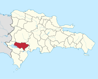
Baoruco, alternatively spelt Bahoruco, is a province of the Dominican Republic located in the southwest of the country, part of the Enriquillo Region, along with the provinces of Barahona, Independencia and Pedernales. Before 1952 it included what is now Independencia Province.

Jimaní Place in Independencia, Dominican Republic

Jimaní is the capital and the second largest city of the Independencia Province of the Dominican Republic. It serves as one of the two main border crossings to Haiti, with a duty-free open-air marketplace operating on the border with Haiti. The town suffered damages in the flash flood of May 25, 2004, which killed many citizens during the night and washed away hundreds of homes.

Vicente Noble Place in Barahona, Dominican Republic

Vicente Noble is a municipality in Barahona province in the Dominican Republic.

Duvergé Place in Independencia, Dominican Republic

Duvergé, also known locally as Las Damas is the largest city in the province of Independencia in the Dominican Republic. The first settlers of this community were the gentlemen Christopher Pérez and María del Pulgar, originating from San Juan de la Maguana.

San Juan de la Maguana Place in San Juan, Dominican Republic

San Juan de la Maguana is a city and municipality in the western region of the Dominican Republic, and capital of the San Juan province. It was one of the first cities established on the island; founded in 1503 and was given the name of San Juan de la Maguana by San Juan Bautista and the Taino name of the valley: Maguana. The term Maguana means "the first stone, the unique stone".

San José de las Matas Place in Santiago, Dominican Republic

San José de las Matas, also known as Sajoma, is an important municipality (municipio) of the Santiago province in the Dominican Republic. The mayor of Sajoma is Roberto Espinal. there has been many positive changes in the last four years such as adding a 911 system. Within the municipality there are three municipal districts : El Rubio, La Cuesta and Las Placetas.

El Cercado Place in San Juan, Dominican Republic

El Cercado is a town in the San Juan province of the Dominican Republic.

Señorita República Dominicana 1979 was held on December 20, 1978. There were 28 candidates who competed for the national crown. The winner represented the Dominican Republic at the Miss Universe 1979. The Señorita República Dominicana Mundo entered Miss World 1979.

Señorita República Dominicana 1978 was held on December 14, 1977. There were 28 candidates who competed for the national crown. The winner represented the Dominican Republic at the Miss Universe 1978. The Señorita República Dominicana Mundo will enter Miss World 1978. Only contestants for 27 provinces and one municipality entered. For the top 10 they showed their evening gown and answered questions so they could go to the top 5. In the top 5 they answered more questions.

Señorita República Dominicana 1976 was held on February 23, 1976. There were 28 candidates who competed for the national crown. The winner represented the Dominican Republic at the Miss Universe 1976. The Virreina al Miss Mundo will enter Miss World 1976. Only the 27 province, 1 municipality entered. On the top 10 they showed their evening gown and answered questions so they could go to the top 5. In the top 5 they would answer more questions.

Señorita República Dominicana 1973 was held on January 29, 1973. There were 28 candidates who competed for the national crown. The winner represented the Dominican Republic at the Miss Universe 1973. The Virreina al Miss Mundo entered Miss World 1973. Only 27 provinces and 1 municipality entered. The top 10 contestants paraded in evening gowns and answered questions to select the top five, who then answered more questions.

Señorita República Dominicana 1972 was held on March 1, 1972. There were 28 candidates who competed for the national crown. The winner represented the Dominican Republic at the Miss Universe 1972. The Virreina al Miss Mundo will enter Miss World 1972. Only the 27 province, 1 municipality entered. On the top 10 they showed their evening gown and answered questions so they could go to the top 5. In the top 5 they would answer more questions.

Señorita República Dominicana 1970 was held on January 24, 1970. There were 28 candidates who competed for the national crown. The winner represented the Dominican Republic at the Miss Universe 1970. The Virreina al Miss Mundo will enter Miss World 1970 and Miss International 1971. Only the 27 province, 1 municipality entered. On the top 10 they showed their evening gown and answered questions so they could go to the top 5. In the top 5 they would answer more questions.

Señorita República Dominicana 1965 was held on February 20, 1965. There were 26 candidates who competed for the national crown. The winner represented the Dominican Republic at the Miss Universe 1965. Only the 25 province and 1 municipality entered. On the top 10 they showed their evening gown and answered questions so they could go to the top 5. In the top 5 they would answer more questions.

Señorita República Dominicana 1962 was held on January 29, 1962, when 26 candidates competed for the national crown. The winner represented the Dominican Republic at the Miss Universe 1962. The first runner up would enter Miss International 1962. Only the 25 provinces and 1 municipality entered. The top ten contestants wore evening gowns and answered questions to get through to the top 5, where they answered more questions.

Mao, Dominican Republic Place in Valverde, Dominican Republic

The Dominican city of Santa Cruz de Mao, or simply Mao, is the head municipality of the Valverde province, in the northwest of the country.

San Juan Province (Dominican Republic) Province of the Dominican Republic

San Juan is a province of the Dominican Republic. Before 1961 it was known as Benefactor. San Juan is the Republic's largest province, bearing a size of 3,569 square kilometers, and it is landlocked.

Sabana Yegua Municipality in Azua, Dominican Republic

Sabana Yegua is a municipality (municipio) of the Azua province in the Dominican Republic.

References

  1. Superficies a nivel de municipios, Oficina Nacional de Estadistica Archived 2009-04-17 at the Wayback Machine
  2. De la Fuente, Santiago (1976). Geografía Dominicana (in Spanish). Santo Domingo, Dominican Republic: Editora Colegial Quisqueyana.
  3. Censo 2002 de Población y Vivienda, Oficina Nacional de Estadistica
  4. "Tamayo Climate Normals 1961-1990". National Oceanic and Atmospheric Administration. Retrieved September 19, 2016.