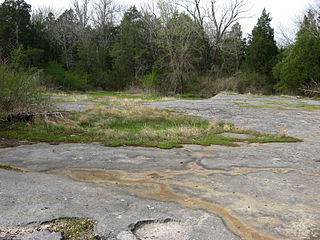
A calcareous glade is a type of ecological community that is found in the central Eastern United States. Calcareous glades occur where bedrock such as limestone occurs near or at the surface, and have very shallow and little soil development. Due to the shallow soil and the extreme conditions created by it, trees are often unable to grow in the glades. This creates a habitat that is usually sunny, dry, and hot. Calcareous glade vegetation is more similar to that of a desert habitat than a grassland, being dominated by small spring annuals with occasional geophytic or succulent perennials.
Big Spring Bog Natural Area Preserve is a 50-acre (20 ha) Natural Area Preserve located in Grayson County, Virginia. The terrain is hilly, and within its borders is Chestnut Creek, a tributary of the New River. The preserve features a rare wetland known as a "cranberry glade".

Buffalo Mountain Natural Area Preserve is a 1,140-acre (4.6 km2) Natural Area Preserve in Floyd County, Virginia.
Cleveland Barrens Natural Area Preserve is a 1,288-acre (5.21 km2) Natural Area Preserve located within the Clinch River Valley in Russell County, Virginia.
Clover Hollow Natural Area Preserve is a Natural Area Preserve located in Giles County, Virginia. The 25-acre (10 ha) preserve protects Stay High Cave, which houses seven rare cave-dwelling invertebrate species, three of which are only known from the county's Sinking Creek Valley. More common species, such as salamanders, crickets, harvestmen, spiders, crayfish, and bats, also live within the cave's streams, riparian mud banks, and drip pools. Most water in the cave stream comes from forested slopes.
Difficult Creek Natural Area Preserve is an 819-acre (3.31 km2) Natural Area Preserve located in Halifax County, Virginia. The preserve aims to restore a portion of Virginia's southern Piedmont to pre-settlement conditions, when the region was dominated by savannas maintained through a natural fire regime. These savannas featured open, prairie-like areas with scattered pines and hardwoods. Management of the preserve includes utilizing prescribed burns and removing loblolly pine plantations to restore the former landscape. Several rare plants, remnants of the original prairie vegetation, survived by colonizing roadsides and power lines; these plants are now protected and encouraged within the preserve.
Grassy Hill Natural Area Preserve is a 1,440-acre (5.8 km2) Natural Area Preserve located in Franklin County, Virginia, just to the west of the town of Rocky Mount. The site is composed of rocky slopes with various hardwood species and patches of Virginia pine. Shallow basic soils, typified by heavy clay, are found among bedrock outcrops rich in magnesium. Rare woodland communities live upon these substrates, and numerous rare plants may be found within grassy forest clearings near the summit. Evidence at the preserve suggests that the majority of the site was once more open, and may have historically been maintained through a natural fire regime that has been suppressed during modern times.
Grayson Glades Natural Area Preserve is a 31-acre (13 ha) Natural Area Preserve located in Grayson County, Virginia. Its centerpiece is an extremely rare wetland type known as a "mafic fen", which are situated upon soils rich in magnesium and fed by springs. The site is at the headwaters of a small stream system supporting additional mafic fens.
Johnsons Creek Natural Area Preserve is a 99-acre (40 ha) Natural Area Preserve located in Alleghany County, Virginia. It contains a variety of trees, including ancient red cedars, oaks, and pines, all of which stand on steep shale bluffs overlooking Johnsons Creek.
Mount Joy Pond Natural Area Preserve is a 274-acre (1.11 km2) Natural Area Preserve located in Augusta County, Virginia in the United States. Located on the western side of the Blue Ridge Mountains, it supports a large population of the rare Virginia sneezeweed. This and other plants are associated with a large sinkhole pond, the centerpiece of the property; fewer than two dozen such ponds remain in Augusta and neighboring Rockingham County. Much of the surrounding landscape consists of hardwoods and pines.
Mutton Hunk Fen Natural Area Preserve is a 516-acre (2.09 km2) Natural Area Preserve located in Accomack County, Virginia. Fronting on the Atlantic Ocean's Gargathy Bay to the east, it is also bounded by Whites Creek and Mutton Hunk Branch to its north. The property contains a rare "sea level fen" community, one of only four in Virginia. Despite the proximity to the ocean's saltwater, freshwater wetland plants are able to survive in this environment due to the influence of freshwater springs. Acidic conditions also encourage the growth of plants normally found in bogs, in addition to tidal freshwater wetland plants; five of the species found at the preserve are regionally rare.
Northwest River Natural Area Preserve is a 2,774-acre (11.23 km2) Natural Area Preserve located in the city of Chesapeake, Virginia. Located along the Northwest River, the preserve protects upland forests as well as swamps and marshes along the river.
Ogdens Cave Natural Area Preserve is a 131-acre (53 ha) Natural Area Preserve located in Frederick County, Virginia. The preserve protects a cave that carries a below-ground branch of Buffalo Marsh Run, which also flows overland through the preserve.
Pinnacle Natural Area Preserve is an 891-acre (361 ha) Natural Area Preserve in Russell County, Virginia. Located at the confluence of the Clinch River and Big Cedar Creek, the preserve's namesake and centerpiece is the Pinnacle, a dolomite formation rising 400 feet (120 m) above the creek.
Pedlar Hills Glades Natural Area Preserve is a 1,036-acre (4.19 km2) Natural Area Preserve located in Montgomery County, Virginia. Rising over the South Fork of the Roanoke River, it supports numerous rare plants and natural communities, including a dolomite barren. Among the species found within the preserve are tall gay-feather and Addison's leatherflower, the latter endemic to Virginia.
Unthanks Cave Natural Area Preserve is a 171-acre (69 ha) Natural Area Preserve in Lee County, Virginia. It protects the entrance to Unthanks Cave, which houses significant biological diversity and a wide variety of invertebrate life. The cave's streams drain a significant karst area south of the Powell River.

Cedars of Lebanon State Park is a state park in Wilson County, Tennessee, in the southeastern United States. It consists of 900 acres (364 ha) situated amidst the 9,420-acre (3,810 ha) Cedars of Lebanon State Forest. The park and forest are approximately 10 miles (16 km) south of Lebanon, Tennessee.

Adams Lake State Park is a public recreation area that surrounds Adams Lake on the far northern edge of the village of West Union, Adams County, Ohio, in the United States. The park's 96 acres (39 ha) are equally divided between land and water and include a rare dry-prairie remnant, Adams Lake Prairie State Nature Preserve. The park offers fishing, boating, picnicking, and hiking.
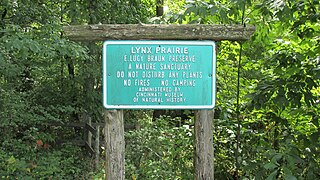
Lynx Prairie is a 52-acre (210,000 m2) nature preserve located in Adams County, Ohio, United States, near the community of Lynx. The preserve features a group of cedar glades which harbor rare prairie species, surrounded by forests on all sides.

The Interior Low Plateaus are a physiographic region in eastern United States. It consists of a diverse landscape that extends from north Alabama across central Tennessee and Kentucky into southern Illinois, Indiana, and Ohio. Its natural communities are a matrix of temperate forests, woodlands, and prairies.

