
Suffolk University is a private research university in Boston, Massachusetts. With 7,560 students, it is the eighth-largest university in metropolitan Boston. It was founded as a law school in 1906 and named after its location in Suffolk County, Massachusetts. The university's notable alumni include mayors, dozens of U.S. federal and state judges and members of the U.S. Congress. The university is also host to its namesake public opinion poll, the Suffolk University Political Research Center.

The Boston Common is a public park in downtown Boston, Massachusetts. It is the oldest city park in the United States. Boston Common consists of 50 acres (20 ha) of land bounded by Tremont Street, Park Street, Beacon Street, Charles Street, and Boylston Street.

Beacon Hill is a historic neighborhood in Boston, Massachusetts, and the hill upon which the Massachusetts State House resides. The term "Beacon Hill" is used locally as a metonym to refer to the state government or the legislature itself, much like Washington, D.C.'s Capitol Hill does at the federal level.
The Pleasant Street incline or Pleasant Street portal was the southern access point for the Tremont Street subway in Boston, Massachusetts, which became part of the Green Line after the incline was closed. The portal and the section of tunnel connecting it to Boylston served streetcars from 1897 to 1901, Main Line Elevated trains from 1901 to 1908, and streetcars again from 1908 to 1962. The Pleasant Street incline is now abandoned, but plans have been floated at various times to reuse it.
Washington Street is a street originating in downtown Boston, Massachusetts that extends southwestward to the Massachusetts–Rhode Island state line. The majority of its length outside of the city was built as the Norfolk and Bristol Turnpike in the early 19th century. It is the longest street in Boston and remains one of the longest streets in the Commonwealth of Massachusetts. Due to various municipal annexations with the city of Boston, the name Washington Street now exists 6 or more times within the jurisdiction(s) of the City of Boston.

The C branch, also called the Beacon Street Line or Cleveland Circle Line, is one of four branches of the Massachusetts Bay Transportation Authority's Green Line light rail system in the Boston, Massachusetts metropolitan area. The line begins at Cleveland Circle in the Brighton neighborhood of Boston and runs on the surface through Brookline along the median of Beacon Street. Reentering Boston, the line goes underground through the St. Mary's Street incline and joins the B and D branches at Kenmore. Trains run through the Boylston Street subway to Copley where the E branch joins, then continue through the Tremont Street subway to downtown Boston. The C branch has terminated at Government Center station since October 2021.

The written history of Boston begins with a letter drafted by the first European inhabitant of the Shawmut Peninsula, William Blaxton. This letter is dated 7 September 1630 and was addressed to the leader of the Puritan settlement of Charlestown, Isaac Johnson. The letter acknowledged the difficulty in finding potable water on that side of Back Bay. As a remedy, Blaxton advertised an excellent spring at the foot of what is now Beacon Hill and invited the Puritans to settle with him on Shawmut.

The Tremont Street subway in Boston's MBTA subway system is the oldest subway tunnel in North America and the third oldest still in use worldwide to exclusively use electric traction, opening on September 1, 1897. It was originally built, under the supervision of Howard A. Carson as chief engineer, to get streetcar lines off the traffic-clogged streets, instead of as a true rapid transit line. It now forms the central part of the Green Line, connecting Boylston Street to Park Street and Government Center stations.

Huntington Avenue is a thoroughfare in the city of Boston, Massachusetts, beginning at Copley Square, and continuing west through the Back Bay, Fenway, Longwood, and Mission Hill neighborhoods. Huntington Avenue is signed as Route 9. A section of Huntington Avenue has been officially designated the Avenue of the Arts by the city of Boston.
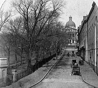
Park Street is a small but historic road in the center of Boston, Massachusetts. It begins at the top of Beacon Hill, at the intersection of Beacon Street, where it is lined up with the front of the Massachusetts State House. It then spills down the hill toward Tremont Street, with Boston Common to its west.

Charles Street is the name of a north-south street in the city center of Boston, Massachusetts. It begins in the north at Leverett Circle, where it connects with Nashua Street and Monsignor O'Brien Highway. Science Park station on the MBTA Green Line is located there. Charles Street runs south and gives its name to the Charles/MGH station on the MBTA Red Line, connecting via the Charles Circle rotary to Cambridge Street and the Longfellow Bridge which leads to Cambridge. This segment is a one-way street, with traffic heading northwards.

Boylston Street is a major east–west thoroughfare in the city of Boston, Massachusetts. The street begins in Boston's Chinatown neighborhood, forms the southern border of the Boston Public Garden and Boston Common, runs through Back Bay, and ends in Boston's Fenway neighborhood.
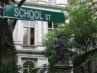
School Street is a short but significant street in the center of Boston, Massachusetts. It is so named for being the site of the first public school in the United States. The school operated at various addresses on the street from 1704 to 1844.
Pemberton Square in the Government Center area of Boston, Massachusetts, was developed by P.T. Jackson in the 1830s as an architecturally uniform mixed-use enclave surrounding a small park. In the mid-19th century both private residences and businesses dwelt there. The construction in 1885 of the massive John Adams Courthouse changed the scale and character of the square, as did the Center Plaza building in the 1960s.

The Central Burying Ground is a cemetery in Boston, Massachusetts. It was established on Boston Common in 1756. It is located on Boylston Street between Tremont Street and Charles Street.
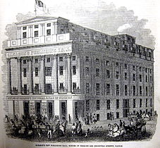
Chickering Hall (est.1883) was a concert auditorium in Boston, Massachusetts, in the late 19th century. It occupied the second floor of Chickering and Sons showrooms on Tremont Street, near the corner of West Street. "Bradlee, Winslow and Wetherell were the architects, and Mr. E.P. Treadwell, the decorator. The hall [was] lighted by the Edison electric light." By 1895: "Tremont St., towards Boylston, for some years has been called Piano Row, for a long row of piano agencies occupied a good portion of the block; but of late most of these have migrated to Boylston St. Chickering Hall, at 152 Tremont St., was for many years a favorite place for fashionable musicales, and the headquarters of the musical profession."

Horticultural Hall (1865–1901) of Boston, Massachusetts, was the headquarters of the Massachusetts Horticultural Society in the later 19th century. It stood at no.100-102 Tremont Street, at the corner of Bromfield Street, opposite the Granary Burying Ground. Architects Gridley J.F. Bryant and Arthur Gilman designed the building. Sculptor Martin Milmore created horticulturally-themed statuary for the building's exterior: "three ancient Roman goddesses ... Ceres, goddess of agriculture; Flora, goddess of flowers; and Pomona, goddess of fruit trees." In the 1880s: "the ground floor [was] occupied by stores; the second story by the Library Room of the society and a hall for the weekly exhibitions; and the upper story by a large and elegant hall used ... at the annual and other important exhibitions. Both of these halls [were] often used for concerts and the better class of entertainments. The society's library, comprising over 4,000 volumes, [was] the most valuable collection of horticultural works in the United States. The halls [were] adorned with portraits and busts of the presidents, founders, and benefactors of the society."
The Boylston Street subway is a light rail tunnel which lies primarily under Boylston Street in Boston, Massachusetts. In operation since 1914, it now carries all four branches of the MBTA Green Line from Kenmore Square under the Back Bay into downtown Boston, where it joins with the older Tremont Street subway. The tunnel originally ended just east of Kenmore Square; it was extended under the square to new portals at Blandford Street and St. Mary's Street in 1932.


