Neighborhoods in Boston

Last updated

Neighborhoods of Boston as defined by the City's Office of Neighborhood Services Boston ONS Neighborhoods.svg
Neighborhoods of Boston as defined by the City's Office of Neighborhood Services

Boston's diverse neighborhoods serve as a political and cultural organizing mechanism. The City of Boston's Office of Neighborhood Services has designated 23 Neighborhoods in the city:

Contents

The islands in Boston Harbor are administered as part of the Boston Harbor Islands National Recreation Area. [1]

The Boston Redevelopment Authority, [2] the City Parking Clerk, [3] and the City's Department of Neighborhood Development [4] have also designated their own neighborhoods. Unofficially, Boston has many overlapping neighborhoods of various sizes. Neighborhood associations have formed around smaller communities or commercial districts (often with "Square" in the name) that have a well-defined center but poorly identified extremities.[ citation needed ]

History of Boston's neighborhoods

As the city of Boston has grown and evolved, its neighborhoods have changed as well. The names of the West End, North End and South End refer to their positions on the Shawmut Peninsula, the original extent of Boston. Due to the annexation of surrounding communities, those neighborhoods are no longer at those geographic extremities. [5] [6] The Back Bay and Bay Village neighborhoods were formerly part of an actual bay, becoming the neighborhoods they are today after landfill projects expanded the size of the city.[ citation needed ] Brighton (including Allston), Charlestown, Dorchester (including South Boston, Mid Dorchester, Mattapan and Hyde Park), Roxbury (including West Roxbury, Roslindale and Jamaica Plain), have all at some point been municipalities independent from downtown Boston, providing a source of well-defined boundaries for the largest areas.[ citation needed ]

Geographic overview

Downtown Boston includes Downtown Crossing, the Financial District and Government Center.

Aerial view of the Back Bay and the neighboring City of Cambridge across the Charles River Boston Back Bay.jpg
Aerial view of the Back Bay and the neighboring City of Cambridge across the Charles River

Surrounding downtown are the neighborhoods of Chinatown/Leather District, South End, North End, West End, Bay Village, Beacon Hill and Back Bay. Chinatown/Leather District is the historical garment district and today has thriving Chinese and other Asian populations. [7] The South End is the center of the city's LGBT population and also populated by artists and young professionals as well as a vibrant African American community. [8] The North End retains an Italian flavor with its many Italian restaurants, though many of its Italian families have moved out, while young professionals have moved in. [9] The Back Bay is west of the Public Garden, and Beacon Hill is the site of the Massachusetts State House. The Back Bay and Beacon Hill are also home to national and local politicians, famous authors and top business leaders and professionals. Bay Village is one of the smallest neighborhoods in Boston and mostly contains Greek Revival-style row houses. [10]

North and east of downtown are the neighborhoods of East Boston and Charlestown. East Boston has a majority of Hispanics, Brazilians, and young professionals, with a remnant of older Italians, and is the site of Logan International Airport. On the north bank of the Charles River is Charlestown; once a predominantly Irish enclave and site of the Bunker Hill Monument, it is now a home for young professionals. [11] [12]

West of downtown are the neighborhoods of Fenway Kenmore, Allston, Brighton, Longwood and Mission Hill. Fenway Kenmore borders the campus of Boston University and houses many college students and young professionals and is the location of Fenway Park. Allston and Brighton are populated heavily by students from nearby universities, as well as recent graduates. Mission Hill is an ethnically diverse neighborhood, adjacent to the Longwood area, which is full of world-class medical institutions. [ citation needed ]

South of downtown are the neighborhoods of Roxbury, Jamaica Plain, Dorchester, Mid Dorchester and South Boston. Dorchester, including Mid Dorchester, is Boston's largest neighborhood and predominantly a working class community considered to be Boston's most diverse. Roxbury is populated largely by African Americans, Caribbean Americans and Latinos and is historically the center of Boston's black community. Jamaica Plain is a community of white professionals and Latinos, and includes the larger side of the Arnold Arboretum. South Boston is a predominantly Irish-American neighborhood, which hosts the city's annual St. Patrick's Day parade. [13]

South of Roxbury, Jamaica Plain and Dorchester are the neighborhoods of Mattapan, Roslindale, Hyde Park and West Roxbury. Roslindale is known for its small business district and includes the smaller side of the Arnold Arboretum. Roslindale has also recently become a majority-minority neighborhood. Mattapan remains the neighborhood with Boston's highest concentrations of African Americans. Hyde Park and West Roxbury have a distinct suburban feel, while still being a part of the city of Boston. Both neighborhoods have large areas of wooded parks and recreation land. Hyde Park is populated largely by African Americans and Caribbean Americans, whereas West Roxbury is predominantly white, but with rapidly growing African American, Middle Eastern and Latino populations. [14] [15] [16]

List of places and squares within neighborhood areas

The 23 official neighborhoods in Boston are made up of approximately 84 sub-districts, squares and neighborhoods within each official neighborhood. The Boston Redevelopment Authority defines 16 planning districts (plus the Boston Harbor Islands) and 64 Neighborhood Statistical Areas (with four areas further subdivided). These correspond roughly with the neighborhoods and sub-neighborhoods of Boston. Unofficially, Boston is made up of approximately 105 neighborhoods.[ citation needed ]

General view of Bay Village Bay Village, Boston, MA - view 4.JPG
General view of Bay Village
Lilac Sunday, Arnold Arboretum, Jamaica Plain Lilac Sunday view, Arnold Arboretum, Jamaica Plain MA.jpg
Lilac Sunday, Arnold Arboretum, Jamaica Plain
North End, Boston North End, Boston.jpg
North End, Boston

Related Research Articles

<span class="mw-page-title-main">Boston Public Library</span> Library in Massachusetts, US

The Boston Public Library is a municipal public library system in Boston, Massachusetts, founded in 1848. The Boston Public Library is also Massachusetts' Library for the Commonwealth, meaning all adult residents of the state are entitled to borrowing and research privileges, and the library receives state funding. The Boston Public Library contains approximately 24 million items, making it the third-largest public library in the United States behind the federal Library of Congress and New York Public Library, which is also privately endowed. In 2014, the library held more than 10,000 programs, all free to the public, and lent 3.7 million materials.

<span class="mw-page-title-main">Fenway–Kenmore</span> Neighborhood in Boston in Suffolk, Massachusetts, United States

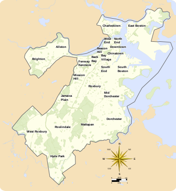
Fenway–Kenmore is an officially recognized neighborhood of Boston, Massachusetts, United States. While it is considered one neighborhood for administrative purposes, it is composed of numerous distinct sections that, in casual conversation, are almost always referred to as "Fenway", "the Fenway", "Kenmore Square", or "Kenmore". Furthermore, the Fenway neighborhood is divided into two sub-neighborhoods commonly referred to as East Fenway/Symphony and West Fenway.

<span class="mw-page-title-main">Allston</span> Neighborhood of Boston in Suffolk, Massachusetts, United States

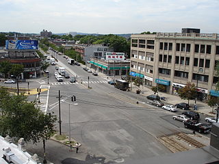
Allston is an officially recognized neighborhood within the City of Boston, Massachusetts, United States. It was named after the American painter and poet Washington Allston. It comprises the land covered by the zip code 02134. For the most part, Allston is administered collectively with the adjacent neighborhood of Brighton. The two are often referred to together as Allston–Brighton. Boston Police Department District D-14 covers the Allston-Brighton area and a Boston Fire Department Allston station is located in Union Square which houses Engine 41 and Ladder 14. Engine 41 is nicknamed "The Bull" to commemorate the historic stockyards of Allston.

<span class="mw-page-title-main">Roslindale</span> Neighborhood of Boston in Suffolk, Massachusetts, United States

Roslindale is a primarily residential neighborhood of Boston, Massachusetts, United States, bordered by Jamaica Plain, Hyde Park, West Roxbury and Mattapan. It is served by an MBTA Commuter Rail line, several MBTA bus lines and the MBTA Orange Line in nearby Jamaica Plain. Roslindale has its own branch of the Boston Public Library, the neighborhood is covered by Boston Police District E-5 in West Roxbury, Boston EMS Ambulance 17 is stationed in Roslindale, and the Boston Fire Department has a station on Canterbury Street which houses Ladder 16, Engine 53 & District Chief 12. Roslindale's original Engine Company 45, was deactivated on April 10, 1981, due to budget cuts. Roslindale was once called the "garden suburb" of Boston. The portion of the Arnold Arboretum south of Bussey Street is located in Roslindale.

<span class="mw-page-title-main">Kenmore Square</span> Square in Boston, Massachusetts, United States

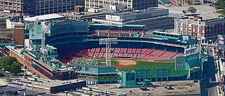
Kenmore Square is a square in the Fenway–Kenmore neighborhood of Boston, Massachusetts. It is formed by the crossing of Beacon Street, Commonwealth Avenue, and Brookline Avenue. It is the eastern terminus of U.S. Route 20, the longest U.S. Highway. The Citgo sign is a prominent landmark in Kenmore Square, and Fenway Park is just to the south. Kenmore station is located under the square, with a surface bus terminal inside the square.

<span class="mw-page-title-main">Mattapan</span> Neighborhood of Boston in Suffolk, Massachusetts, United States

Mattapan is a neighborhood in Boston, Massachusetts, United States. Historically and for legal processes a section of Dorchester, Mattapan became a part of Boston when Dorchester was annexed in 1870. Mattapan is the original Native American name for the Dorchester area, possibly meaning "a place to sit." At the 2010 census, it had a population of 36,480, with the majority of its population immigrants.

<span class="mw-page-title-main">MBTA key bus routes</span> Bus routes utilized and ran by the MBTA

Key bus routes of the Massachusetts Bay Transportation Authority (MBTA) system are 15 routes that have high ridership and higher frequency standards than other bus lines, according to the 2004 MBTA Service Policy. Together, they account for roughly 40% of the MBTA's total bus ridership. These key bus routes ensure basic geographic coverage with frequent service in the densest areas of Boston, and connect to other MBTA services to give access to other areas throughout the region.

<span class="mw-page-title-main">Washington Street (Boston)</span> Street in Boston, Massachusetts

Washington Street is a street originating in downtown Boston, Massachusetts, which extends southwestward to the Massachusetts–Rhode Island state line. The majority of its length outside of the city was built as the Norfolk and Bristol Turnpike in the early 19th century. It is the longest street in Boston and remains one of the longest streets in the Commonwealth of Massachusetts. Due to various municipal annexations with the city of Boston, the name Washington Street now exists 6 or more times within the jurisdiction(s) of the City of Boston.

<span class="mw-page-title-main">Green Line E branch</span> Light rail line

The E branch is a light rail line in Boston, Cambridge, Medford, and Somerville, Massachusetts, operating as part of the Massachusetts Bay Transportation Authority (MBTA) Green Line. The line runs in mixed traffic on South Huntington Avenue and Huntington Avenue between Heath Street and Brigham Circle, in the median of Huntington Avenue to Northeastern University, then into the Huntington Avenue subway. The line merges into the Boylston Street subway just west of Copley, running to North Station via the Tremont Street subway. It then follows the Lechmere Viaduct to Lechmere, then the Medford Branch to Medford/​Tufts. As of February 2023, service operates on eight-minute headways at weekday peak hours and eight to nine-minute headways at other times, using 13 to 17 trains.

<span class="mw-page-title-main">Boston-area streetcar lines</span>

As with many large cities, a large number of Boston-area streetcar lines once existed, and many continued operating into the 1950s. However, only a few now remain, namely the four branches of the Green Line and the Ashmont–Mattapan High-Speed Line, with only one running regular service on an undivided street.

<span class="mw-page-title-main">Washington Street Elevated</span> Former elevated railroad in Boston, Massachusetts

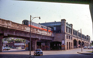
The Washington Street Elevated was an elevated segment of Boston's Massachusetts Bay Transportation Authority subway system, comprising the southern stretch of the Orange Line. It ran from Chinatown through the South End and Roxbury, ending in Forest Hills in Jamaica Plain, Boston.

<span class="mw-page-title-main">Tremont Street subway</span> Boston subway tunnel

The Tremont Street subway in Boston's MBTA subway system is the oldest subway tunnel in North America and the third-oldest still in use worldwide to exclusively use electric traction, opening on September 1, 1897. It was originally built, under the supervision of Howard A. Carson as chief engineer, to get streetcar lines off the traffic-clogged streets, instead of as a true rapid transit line. It now forms the central part of the Green Line, connecting Boylston Street to Park Street and Government Center stations.

The Boston Park League, located in Boston, Massachusetts, is the oldest amateur baseball league in the United States.

<span class="mw-page-title-main">Forest Hills, Boston</span> United States historic place

Forest Hills is a part of the Jamaica Plain neighborhood of Boston, Massachusetts, United States. Forest Hills is characterized by hilly terrain and wooded areas within and adjacent to its borders. In general, the area slopes upward from Hyde Park Ave and downward from Walk Hill Street.

<span class="mw-page-title-main">Brookline Avenue</span>

Brookline Avenue is a principal urban artery in the city of Boston, Massachusetts. It runs from Kenmore Square in the Fenway-Kenmore neighborhood, forming a 1.5-mile straight line to its other terminus at Washington Street in the Brookline Village neighborhood of Brookline, Massachusetts. The Landmark Center, Fenway Park, Emmanuel College, Longwood Medical and Academic Area and Kenmore Square are sites along its length.

The Spirit of Adventure Council is a regional council of the Boy Scouts of America. It serves the greater Boston, Massachusetts, area.

The Boston Directory of Boston, Massachusetts, was first published in 1789. It contained "a list of the merchants, mechanics, traders, and others, of the town of Boston; in order to enable strangers to find the residence of any person." Also included were listings for public officials, doctors, bank directors, and firemen. The directory was issued annually after 1825; previously it had appeared irregularly.

<span class="mw-page-title-main">Stony Brook (Charles River tributary, Boston)</span> Buried river in Boston, Massachusetts

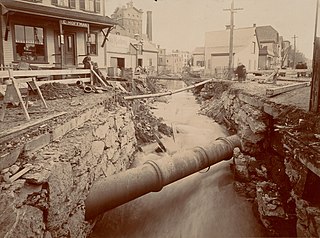
Stony Brook is a 8.5-mile (13.7 km)-long subterranean river in Boston. The largest tributary stream of the lower Charles River, it runs mostly through conduits. Stony Brook originates at Turtle Pond in the Stony Brook Reservation and flows through Hyde Park, Roslindale, Jamaica Plain, and Roxbury. It empties into the Charles River Basin just upstream of the Harvard Bridge. Stony Brook is fed by four tributaries, all of which are partially or entirely in conduits as well.

<span class="mw-page-title-main">Boston & Roxbury Mill Dam</span> Dam in Boston, Massachusetts

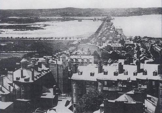
The Boston & Roxbury Mill Dam was an engineering project in Boston's Back Bay. Commissioned in 1814, the project intended to enclose the Back Bay basin and utilize the flowing tidal waters for industrial production. Constructing the dam would allow water to reliably flow from the Charles River to the basin, creating an ideal environment for the era's industrial mills. The project additionally added a second route to the mainland that redirected traffic away from Boston's choked Orange Street causeway. Between 1818 and 1821, the dam was constructed by extending Beacon Street westward.

<span class="mw-page-title-main">Ipswich Street line</span> Former streetcar line in Boston and Brookline, Massachusetts

The Ipswich Street line was a streetcar line in Boston and Brookline, Massachusetts. The line ran on Boylston Street and Ipswich Street in the Fenway–Kenmore neighborhood, and on Brookline Avenue through what is now the Longwood Medical Area to Brookline Village.

References

  1. "Neighborhoods". City of Boston. 13 October 2017. Retrieved December 14, 2020.
  2. "Neighborhoods". Boston Redevelopment Authority. Retrieved 30 January 2014.
  3. "Resident Parking Permit - New". City of Boston. Retrieved 30 January 2014.
  4. "About DND". City of Boston. Retrieved 30 January 2014.
  5. "FA 267". Bc.edu. Archived from the original on 2007-04-10. Retrieved 2012-02-23.
  6. "The Original Shawmut Peninsula". Iboston.org. Retrieved 2012-02-23.
  7. "Chinatown: Exploring Boston's Neighborhoods" (PDF). City of Boston. Archived from the original (PDF) on 24 July 2015. Retrieved 30 January 2014.
  8. "A Short History of Boston's South End". South-end-boston.com. 2006-06-30. Retrieved 2012-02-23.
  9. Goldfield, Alex R. The North End: A Brief History of Boston's Oldest Neighborhood. Charleston, SC: The History Press, 2009.
  10. "Beacon Hill & Bay Village: Exploring Boston's Neighborhoods" (PDF). City of Boston. Archived from the original (PDF) on 20 July 2011. Retrieved 30 January 2014.
  11. "Charlestown, a historic treasure". Relohomesearch.com. Archived from the original on 2012-03-01. Retrieved 2012-02-23.
  12. Rocheleau, Matt (April 6, 2011). "Census data: Hispanics/Latinos surpass whites in East Boston". Boston.com . Archived from the original on February 28, 2015.
  13. Warner, Sam Bass. Streetcar Suburbs: The Process of Growth in Boston, 1870-1900. Cambridge, Massachusetts: Harvard University Press, 1978.
  14. Rocheleau, Matt (April 6, 2011). "Census data: African Americans now outnumber whites in Hyde Park". Boston.com . Archived from the original on February 28, 2015.
  15. Rocheleau, Matt (April 6, 2011). "Census data: West Roxbury's minority populations boomed from 2000". Boston.com . Archived from the original on February 28, 2015.
  16. Rocheleau, Matt (April 6, 2011). "Census data: Mattapan's population dropped at second-highest rate in city". Boston.com . Archived from the original on February 28, 2015.
  17. "Boston National Historical Park - Charlestown Navy Yard (U.S. National Park Service)". Nps.gov. 2008-05-04. Retrieved 2012-02-23.
  18. "Boston Redevelopment Authority" (PDF). Cityofboston.gov. Archived from the original (PDF) on 2008-04-10. Retrieved 2012-02-23.
  19. Boston schoolyard sites Archived 2007-04-27 at the Wayback Machine
  20. "Mid-Dorchester Action Plan". City of Boston. Retrieved 30 January 2014.
  21. Four Corners Main Street
  22. Egleston Square Neighborhood Association
  23. "South Boston Waterfront | ICA, Legal Harborside, Cruiseport, Children's Museum". Boston-discovery-guide.com. Retrieved 2012-02-23.
  24. City Point Neighborhood Association, South Boston

Lists of neighborhoods

Neighborhood guides