Government Center, Boston

Last updated
View of Government Center from the Custom House Tower Government Center Boston aerial 2016.JPG
View of Government Center from the Custom House Tower

Government Center is an area in downtown Boston, centered on City Hall Plaza. Formerly the site of Scollay Square, it is now the location of Boston City Hall, courthouses, state and federal office buildings, and a major MBTA subway station, also called Government Center. Its development was controversial, as the project displaced thousands of residents and razed several hundred homes and businesses. [1]

Contents

Controversial in design since before it was completed, the use of Brutalist architecture for its main buildings, as well as the open brick-and-concrete plaza at the center of the development, have been alternately praised for its innovative design, and scorned for its lack of character and uninviting appearance. After decades of calls for a redesign to make it more friendly and usable, a major rebuild of City Hall Plaza, the main public space of Government Center, was begun in 2020 and is to include additional seating areas, play spaces for children, and space for public art. [2]

History

Post-colonial development and commerce

Scollay Square was named for William Scollay, a prominent local developer and militia officer who bought a landmark four-story merchant building at the intersection of Cambridge and Court Streets in 1795. Local citizens began to refer to the intersection as Scollay's Square, and, in 1838, the city officially memorialized the intersection as Scollay Square.

Early on, the area was a busy center of commerce, including the city's first daguerreotypist (photographer), Josiah Johnson Hawes (18081901), and Dr. William Thomas Green Morton, the first dentist to use ether as an anaesthetic.

Local cultural landmarks took form, attracting visits from such intellectual contemporaries as Charles Dickens.

Abolitionism

Militia tries to maintain order in Scollay Square during the 1919 Boston Police Strike. Boston Police Strike.jpg
Militia tries to maintain order in Scollay Square during the 1919 Boston Police Strike.

Scollay Square was also a flashpoint for the early abolition movement. Author William Lloyd Garrison was twice attacked by an angry mob for printing his anti-slavery newspaper The Liberator , which began publication in 1831. Sarah Parker Remond's first act of civil disobedience occurred in 1853 at the Old Howard when she was refused the seat she had purchased but was instead seated in the 'black' section. Many of the buildings in the area in and around Scollay Square had hidden spaces where escaped slaves were hidden, as part of the Underground Railroad.

The Old Howard

Scollay Square in the 1880s Scollay1880s.jpg
Scollay Square in the 1880s

Among the most famous (and infamous) of Scollay Square landmarks was the Old Howard Theatre, a grand theater which began life as the headquarters of a Millerite Adventist Christian sect which believed the world would end in October 1844. After the world failed to end on schedule, the building was sold in 1844 and reopened as a vaudeville and Shakespearean venue. Later, in the 1900s and 1910s, it would showcase the popular minstrel shows.

By around the 1940s the Scollay Square area began to lose its vibrant commercial activity, and the Howard gradually changed its image and began to cater to sailors on leave and college students by including burlesque shows, as did other nearby venues such as the Casino Theater and Crawford House. "Always Something Doing" became the Old Howard's advertising slogan. The venue also showcased boxing matches with such old-time greats as local Rocky Marciano and John L. Sullivan, and continued to feature slapstick vaudeville acts, from likes of The Marx Brothers and Abbott and Costello.

But it was the success and prominence of the burlesque shows that brought the Old Howard down. In 1953, vice squad agents sneaked a home movie camera into the Old Howard, and caught Mary Goodneighbor on film doing her striptease for the audience. The film led to the closure of the theater, and it remained closed until it caught fire mysteriously in 1961.

The square was also the home of Austin and Stone's Dime Museum.

Destruction and redevelopment

As early as the 1950s, city officials had been mulling plans to completely tear down and redevelop the Scollay Square area, in order to remove lower-income residents and troubled businesses from the aging and seedy district. Attempts to reopen the sullied Old Howard by its old performers had been one of the last efforts against redevelopment; but with the theater gutted by fire, a city wrecking ball began the project of demolishing over 1000 buildings in the area; 20,000 residents were displaced.

With $40 million in federal funds, the city built an entirely new development on top of old Scollay Square, renaming the area Government Center, and peppering it with city, state, and federal government buildings.

A 1958 report by the Boston Planning Board, entitled Government Center Project, set out the case for construction of a center:

The future of Boston depends in large degree on how effectively and efficiently it continues to perform its role as the central city of an important metropolitan area and as the regional center for New England. ... One of the basic functions of such a regional center is the provision of governmental services at all levels. ... At the present time the accommodations in Boston for all levels of government are inadequate and inefficient. [3]

Major structures

Boston City Hall

Boston City Hall Boston City Hall 5.JPG
Boston City Hall

The dominant feature of Government Center is the enormous, imposing, and brutalist Boston City Hall, [4] designed by Kallmann McKinnell & Wood and built in the 1960s as part of Boston's first large urban renewal scheme. While considered by some to have architectural merit, the building is not universally admired, and is sharply unpopular among locals. Furthermore, it is resented for having replaced the Victorian architecture of Boston's Scollay Square, [5] a lively commercial district that lapsed into squalor in the twentieth century. [6]

John Fitzgerald Kennedy Federal Building

John Fitzgerald Kennedy Federal Building is a United States government office building. It is located across City Hall Plaza from Boston City Hall. An example of 1960s modern architecture, it consists of two 26 floor towers that sit on-axis to each other and a low rise building of four floors that connects to the two towers via an enclosed glass corridor. The two towers stand at a height of 118 meters (387 ft).

City Hall Plaza

City Hall Plaza, c. 1968 Boston City Hall 01.jpg
City Hall Plaza, c. 1968

City Hall Plaza is not a well-loved space, either. As Bill Wasik wrote in 2006, "It is as if the space were calibrated to render futile any gathering, large or small, attempted anywhere on its arid expanse. All the nearby buildings seem to be facing away, making the plaza's 11 acres (45,000 m2) of concrete and brick feel like the world's largest back alley. ... [It is] so devoid of benches, greenery, and other signposts of human hospitality that even on the loveliest fall weekend, when the Common and Esplanade and other public spaces teem with Bostonians at leisure, the plaza stands utterly empty save for the occasional skateboarder…" [7] The plaza is often colloquially referred to as "the brick desert." [8]

Government Service Center

Government Service Center 2010 NewChardonSt Boston.jpg
Government Service Center

Another very large Brutalist building at Government Center, less prominently located and thus less well known than City Hall, is the Government Service Center, designed by architect Paul Rudolph. The building is unfinished as the tall central tower in the original plan was never built. In the mid-1990s, the adjacent space was filled with the Edward W. Brooke Courthouse, which houses a division of the Boston Municipal Court. This irregularly shaped, sloping lot was the last parcel to be developed of the Government Center urban renewal plan; in the interim the space was used as surface parking. In a 2014 article, architectural historian Timothy M. Rohan praised the building for having "a wondrous interior courtyard like something from baroque Rome, a space that even in its incomplete and neglected state contrasts sharply with nearby City Hall and its alienating plaza." [9]

Government Center Garage

This 2,300-space privately owned garage [10] was built as part of the Government Center urban renewal project. In 2016, the Boston Redevelopment Authority gave final approval [11] for the replacement of the garage with "Bulfinch Crossing," [12] a 2.9-million-square-foot (270,000 m2) mixed-use development [13] [14] [15] designed by Pelli Clarke Pelli Architects. [16] Construction began in January 2017. [17] The design of the office tower was revealed in June 2019. [18]

Center Plaza

Center Plaza 2005 Government Center Boston.jpg
Center Plaza

This 720,000 square foot (67,000 m2) office and retail structure, built by developer Norman B. Leventhal, is across Cambridge Street from City Hall Plaza. In 2014, the property was sold [19] by the Blackstone Group to Shorenstein Properties. [20] Shorenstein Properties has proposed a $25 million renovation [21] designed "to add some new buzz" to the building. [22] The renovation was approved by the Boston Redevelopment Authority in 2016. [23]

Nearby public buildings

Several state and federal government buildings near Government Center were not built as part of the urban renewal project. These include the Massachusetts State House, the McCormack Building, the Saltonstall Building, [24] the Suffolk County Courthouse, and the Thomas P. O'Neill Jr. Federal Building.

Sears' Crescent and Sears' Block

The Sears' Crescent and Sears' Block are a pair of 19th century buildings that border City Hall Plaza on the south.

The golden steaming kettle mounted on the corner of the Sears' Block, 63-65 Court Street, pre-dates the Government Center redevelopment. It was manufactured for the Oriental Tea Company in 1873, which held a contest to guess the volume of the kettle and staged a spectacle in which nine children and a tall man crawled out of the kettle. Its volume was measured by the city's official sealer of weights and measures at 227 gallons, 2 quarts, 1 pint, and 3 gills, (861.1 L) which for a time was painted on the side. The tea shop at 85-87 Court Street was demolished, but the owner, Nathan Sharaf, opened Steaming Kettle Coffee Shop in the new building and mounted the kettle. It became Croissant Du Jour in 1988, then Coffee Connection, then Starbucks in 1997. [25]

Geography and transportation

Government Center is located between the North End, Downtown, and Beacon Hill neighborhoods.

Boundaries

Government Center does not have official boundaries. A 2011 Boston Redevelopment Authority map of Boston neighborhoods [26] shows most of the Government Center area as part of the Downtown neighborhood, and the rest as part of the West End.

Other maps and documents show a variety of different boundaries for Government Center. The Boston Zoning Code has a map called "1H Government Center/Markets District." [27] The map shows the Government Center portion of the district extending as far west as the Massachusetts State House and including all of the major structures listed in this article. The Boston Redevelopment Authority map of "Urban Renewal Areas" [28] includes a somewhat smaller area that excludes the McCormack and Saltonstall Buildings.

By contrast, a search for "Government Center" on Google Maps [29] yields a map showing an even smaller area that is bounded by Court, Cambridge, Sudbury, and Congress Streets. The AirBnB neighborhood map [30] shows a somewhat larger area than the Google Map. An undated Boston Redevelopment Authority map entitled "Government Center Urban Renewal Area Illustrative Site Plan" [31] showed similar boundaries.

Mass transit

Government Center station upon reopening in March 2016 Government Center station on reopening day, March 2016.jpg
Government Center station upon reopening in March 2016

Scollay Square station opened as part of the third phase of the Tremont Street Subway in September 1898, bringing subway service to the area with a stone headhouse in the center of the square. Court Street station opened on the East Boston Tunnel in December 1904; it was closed in 1914 and replaced by a lower level (Scollay Under) to the Scollay Square station in 1916. [32] The station was rebuilt in 1963 as Government Center station with a low brick headhouse, and again from 2014 to 2016 with a large glass headhouse that dominates the south side of the plaza. [33] It serves as the transfer point between the MBTA's Blue and Green Lines.

Surroundings

Government Center is adjacent to historic Faneuil Hall and popular Quincy Market and very near the Old State House. It is two blocks away from the Rose Fitzgerald Kennedy Greenway, which was created as part of the Big Dig. Major city streets in the vicinity include Tremont, Congress, Cambridge, State, New Chardon, and Washington Streets. Hints of another street, Cornhill, still exist along one edge of City Hall Plaza. Two of the neighborhood's few remaining old buildings, the Sears' Crescent and Sears' Block, face the plaza and follow the original curve of Cornhill. A veteran's home & services provider, [34] still has an entrance with a Cornhill address. Plans for Government Center, including the Boston Redevelopment Authority's "Government center 2000 project", [35] called for the construction of two footbridges over Congress Street to connect City Hall Plaza to the Faneuil Hall area. Neither bridge was built.

See also

History of the site

Related Research Articles

<span class="mw-page-title-main">Roxbury, Boston</span> Neighborhood of Boston in Massachusetts, United States

Roxbury is a neighborhood within the City of Boston, Massachusetts, United States.

<span class="mw-page-title-main">South End, Boston</span> Neighborhood of Boston, Massachusetts

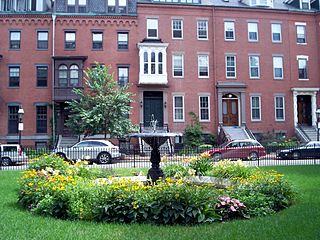
The South End is a neighborhood in Boston, Massachusetts, which is bordered by Back Bay, Chinatown, and Roxbury. It is distinguished from other neighborhoods by its Victorian-style houses and the parks in and around the area. The South End is the largest intact Victorian row-house district in the country, covering over 300 acres (120 ha). It has eleven residential parks. In 1973, the South End was listed on the National Register of Historic Places. Much of the neighborhood was originally marshlands in Boston's South Bay. After it was filled in, construction began in 1849.

<span class="mw-page-title-main">Davis Square</span> Neighborhood in Somerville, Massachusetts

Davis Square is a major intersection in the northwestern section of Somerville, Massachusetts, where several streets meet: Holland Street, Dover Street, Day Street, Elm Street, Highland Avenue, and College Avenue. The name is often used to refer to the West Somerville neighborhood surrounding the square as well.

<span class="mw-page-title-main">Government Center station (MBTA)</span> Subway station in Boston, Massachusetts, US

Government Center station is an MBTA subway station in Boston, Massachusetts. It is located at the intersection of Tremont, Court and Cambridge Streets in the Government Center area. It is a transfer point between the light rail Green Line and the rapid transit Blue Line. With the Green Line platform having opened in 1898, the station is the third-oldest operating subway station in the MBTA system; only Park Street and Boylston are older. The station previously served Scollay Square before its demolition for the creation of Boston City Hall Plaza.

<span class="mw-page-title-main">L'Enfant Plaza</span> Building complex in Washington, D.C.

L'Enfant Plaza is a complex of four commercial buildings grouped around a large plaza in the Southwest section of Washington, D.C., United States. Immediately below the plaza and the buildings is La Promenade shopping mall.

<span class="mw-page-title-main">Haymarket station (MBTA)</span> Subway station in Boston, Massachusetts, US

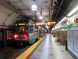
Haymarket station is an underground Massachusetts Bay Transportation Authority (MBTA) rapid transit station located at Haymarket Square in Boston, Massachusetts. It is a transfer station between the Green Line and Orange Line of the MBTA subway system, as well as a terminal for MBTA bus routes serving northern and northeastern suburbs. The two lines run parallel to each other through the station, with two side platforms for the Orange Line and a single island platform for the Green Line. The station is fully accessible.

<span class="mw-page-title-main">Beacon Hill, Boston</span> Historic neighborhood in Boston, Massachusetts

Beacon Hill is a historic neighborhood in Boston, Massachusetts, and the hill upon which the Massachusetts State House resides. The term "Beacon Hill" is used locally as a metonym to refer to the state government or the legislature itself, much like Washington, D.C.'s Capitol Hill does at the federal level.

<span class="mw-page-title-main">Scollay Square</span> Former public square in downtown Boston, Massachusetts

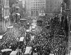
Scollay Square was a vibrant city square in downtown Boston, Massachusetts. It was named for William Scollay, a prominent local developer and militia officer who bought a landmark four-story merchant building at the intersection of the Cambridge and Court Streets in the year 1795. Local citizens began to refer to this intersection as Scollay's Square, and, in 1838, the city officially memorialized the intersection as the Scollay Square. Early on, the area was a busy center of commerce, including daguerreotypist (photographer) Josiah Johnson Hawes (1808–1901) and Dr. William Thomas Green Morton, the first dentist to use ether as an anaesthetic.

<span class="mw-page-title-main">Haymarket Square (Boston)</span> Historic name of a former town square in Boston, Massachusetts, United States

Haymarket Square is the historic name of a former town square in Boston, located between the North End, Government Center, the Bulfinch Triangle, and the West End. The square was a well-known feature of Boston from the mid-19th century to the mid-20th century, when the buildings around it were demolished to make way for the Central Artery and Government Center. The Haymarket produce market continues to operate at a location near the historic site of the square. The Haymarket MBTA station extends under the former site of the square.

<span class="mw-page-title-main">Boston City Hall</span> City hall of Boston, Massachusetts since 1969

Boston City Hall is the seat of city government of Boston, Massachusetts. It includes the offices of the mayor of Boston and the Boston City Council. The current hall was built in 1968 to assume the functions of the Old City Hall.

<span class="mw-page-title-main">West End, Boston</span> Neighborhood of Boston in Suffolk, Massachusetts, United States

The West End is a neighborhood of Boston, Massachusetts, bounded generally by Cambridge Street to the south, the Charles River to the west and northwest, North Washington Street on the north and northeast, and New Sudbury Street on the east. Beacon Hill is to the south, North Point is across the Charles River to the north, Kendall Square is across the Charles River to the west, and the North End is to the east. A late 1950s urban renewal project razed a large Italian and Jewish enclave and displaced over 20,000 people in order to redevelop much of the West End and part of the neighboring Downtown neighborhood. After that, the original West End became increasingly non-residential, including part of Government Center as well as much of Massachusetts General Hospital and several high rise office buildings. More recently, however, new residential buildings and spaces, as well as new parks, have been appearing across the West End.

<span class="mw-page-title-main">Boston Planning & Development Agency</span> Municipal planning and development agency for Boston

The Boston Planning & Development Agency (BPDA), formerly the Boston Redevelopment Authority (BRA), is a Massachusetts public agency that serves as the municipal planning and development agency for Boston, working on both housing and commercial developments.

<span class="mw-page-title-main">One Lincoln Street</span> Skyscraper in Boston, Massachusetts

One Lincoln Street, also known as State Street Financial Center, is a skyscraper in Boston, Massachusetts on the edge of both the Financial District and neighborhood of Chinatown. Completed in 2003, it was built using Boston Redevelopment Authority (BRA) guidelines. Standing at 503 feet tall, One Lincoln Street is the 21st-tallest building in Boston. The skyscraper has a five-level underground garage that provides parking for 900 cars. It contains 1 million square feet of office space.

<span class="mw-page-title-main">Downtown Boston</span> Area of Boston, Massachusetts

Downtown Boston is the central business district of Boston, Massachusetts, United States. Boston was founded in 1630. The largest of the city's commercial districts, Downtown is the location of many corporate or regional headquarters; city, county, state and federal government facilities; and many of Boston's tourist attractions. Similar to other central business districts in the U.S., Downtown has recently undergone a transformation that included the construction of new condos and lofts, renovation of historic buildings, and arrival of new residents and businesses. It is represented in the Boston City Council by District 2's Bill Linehan.

<span class="mw-page-title-main">Boston Government Service Center</span> Government complex in Boston, Massachusetts

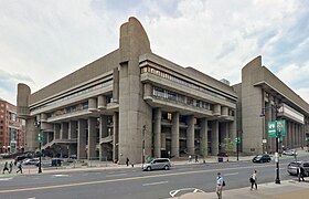
The Boston Government Service Center (BGSC) is a state government complex in the West End of Boston, Massachusetts. The center was designed in the Brutalist style, led by architect Paul Rudolph. It is one of the major components of the Government Center complex in Downtown Boston. The complex is made up of two connected Brutalist buildings: the Charles F. Hurley Building and the Erich Lindemann Building, as well as a courtyard; sometimes included is the newer, 1998-built, Edward W. Brooke Courthouse.

<span class="mw-page-title-main">Pemberton Square</span>

Pemberton Square in the Government Center area of Boston, Massachusetts, was developed by P.T. Jackson in the 1830s as an architecturally uniform mixed-use enclave surrounding a small park. In the mid-19th century both private residences and businesses dwelt there. The construction in 1885 of the massive John Adams Courthouse changed the scale and character of the square, as did the Center Plaza building in the 1960s.

<span class="mw-page-title-main">Boston City Hall Plaza</span>

City Hall Plaza in Boston, Massachusetts, is a large, open, public space in the Government Center area of the city. The architectural firm Kallmann McKinnell & Knowles designed the plaza in 1962 to accompany Boston's new City Hall building. The multi-level, irregularly shaped plaza consists of red brick and concrete. The Government Center MBTA station is located beneath the plaza; its entrance is at the southwest corner of the plaza.

<span class="mw-page-title-main">Boston Public Market</span>

The Boston Public Market is an indoor public market that opened in July 2015 in downtown Boston, adjacent to the Rose Fitzgerald Kennedy Greenway. The market houses more than 28 year-round vendor stalls, and is open seven days a week. Vendors for the indoor market are selected by the operator, the non-profit Boston Public Market Association, and must sell food and other products that are produced or originate in New England, as well as a limited amount of certain produce that is not able to grow in New England. The market was the first in the United States with an all-local-food requirement. The association operates a second seasonal outdoor farmers' market in Dewey Square, near the southern end of the Greenway.

<span class="mw-page-title-main">Adams Square (Boston)</span>

Adams Square (1879–1963) was a square in downtown Boston, Massachusetts. Now demolished, it was formerly located on the site of the current Boston City Hall in Government Center.

Bulfinch Crossing is a redevelopment project currently under construction in Downtown Boston, Massachusetts, United States. It will consist of two skyscrapers, a smaller residential tower, a low-rise office building, a hotel, and a low-rise retail building. Site preparation began in late 2015, and construction officially commenced on January 24, 2017. Construction on the residential tower completed in 2020. The high-rise office tower, One Congress, commenced construction in 2019 and topped off in July 2021; after an announced plan to open in 2022, it officially opened in September 2023.

References

  1. Government center: map and directory of business firms each employing twenty or more persons. Boston Redevelopment Authority. 1961. Retrieved 22 April 2020.
  2. Howard, Marcus E. (8 August 2021). "City Hall Plaza renovations half finished, according to architect". Boston.com. Retrieved 28 January 2022.
  3. Government Center Project (PDF) (Report). Boston City Planning Board. January 1958. Retrieved 29 April 2020.
  4. Southworth & Southworth. AIA Guide to Boston, 3rd ed. 2008; p.52.
  5. "History of Scollay Square". BambinoMusical.com. Retrieved 13 April 2016.
  6. Mapping Boston, Krieger, Alex, ed., MIT Press 1999, p.163-165. Lost Boston, by Jane Holtz Kay, p.110.
  7. Wasik, Bill (2009). And Then There's This: How Stories Live and Die in Viral Culture . Viking. ISBN   978-0670020843.
  8. Ulam, Alex. "Softening Boston's City Hall". The Architect's Newspaper. Retrieved 13 April 2016.
  9. Rohan, Timothy M. (7 September 2014). "The dream behind Boston's forbidding Government Service Center". The Boston Globe. Retrieved 17 September 2016.
  10. "Government Center Garage". Archived from the original on 14 December 2021. Retrieved 18 January 2022.
  11. Logan, Tim (15 January 2016). "Government Center Garage to give way to two glass skyscrapers". Boston Globe. Retrieved 13 April 2016.
  12. "Bulfinch Crossing". HYM Investment Group. Retrieved 22 June 2016.
  13. Ross, Casey (23 June 2011). "Ambitious plan for Government Center Garage site". Boston Globe. Retrieved 13 April 2016.
  14. Logan, Tim (26 May 2016). "In Government Center, a nifty development trick". Boston Globe. Retrieved 29 April 2020.
  15. "Government Center Garage Redevelopment". BostonRedevelopmentAuthority.org. Retrieved 13 April 2016.
  16. "One Congress at Bulfinch Crossing". Pelli Clarke Pelli Architects. Retrieved 29 April 2020.
  17. Acitelli, Tom (25 January 2017). "Bulfinch Crossing construction officially starts". Curbed Boston. Retrieved 31 January 2017.
  18. Cogley, Bridget (28 June 2019). "Pelli Clarke Pelli unveils folded glass One Congress tower in Boston". Dezeen. Retrieved 15 August 2019.
  19. Grillo, Thomas (9 January 2014). "Blackstone's Equity Office sells 1-3 Center Plaza for $307 million". Boston Business Journal. Retrieved 16 April 2016.
  20. "Center Plaza". Shorenstein Properties.
  21. "Center Plaza" . Retrieved 27 August 2016.
  22. Carlock, Catherine (27 July 2015). "Shorenstein's planned $25M renovation of Center Plaza in downtown Boston". Boston Business Journal. Retrieved 16 April 2016.
  23. "Center Plaza". Boston Redevelopment Authority. Retrieved 16 April 2016.
  24. "The Saltonstall Building". Restoring the Urban Fabric. Matthew Lawlor. 21 October 2009. Retrieved 21 April 2016.
  25. Chloe Courtney Bohl (November 28, 2023). "Wickedpedia: What's the story of the steaming tea kettle outside the Government Center Starbucks?". Boston.com.
  26. "Boston Neighborhoods". BostonRedevelopmentAuthority.org. Retrieved 21 April 2016.
  27. "Map 1H Government Center/Markets District". Boston Redevelopment Authority. Retrieved 12 November 2016.
  28. "Urban Renewal Areas". BostonRedevelopmentAuthority.org. Retrieved 21 April 2016.
  29. "Government Center". Google Maps. Retrieved 16 April 2016.
  30. "Government Center". AirBnB. Retrieved 17 April 2016.
  31. "Government Center Urban Renewal Area Illustrative Site Plan". Boston Redevelopment Authority. Retrieved 13 June 2015.
  32. Belcher, Jonathan (19 March 2016). "Changes to Transit Service in the MBTA district 1964-2016" (PDF). NETransit. Retrieved 21 March 2016.
  33. Moskowitz, Eric (21 March 2016). "Government Center reopens". Boston Globe. Retrieved 21 March 2016.
  34. "New England Center and Home for Veterans" . Retrieved 21 April 2016.
  35. Government center 2000 project. Boston Redevelopment Authority. 12 December 1988. p. 22. Retrieved 22 April 2020.

Further reading

42°21′38.52″N71°03′33.22″W / 42.3607000°N 71.0592278°W / 42.3607000; -71.0592278