Katanga was one of the four large provinces created in the Belgian Congo in 1914. It was one of the eleven provinces of the Democratic Republic of the Congo between 1966 and 2015, when it was split into the Tanganyika, Haut-Lomami, Lualaba, and Haut-Katanga provinces. Between 1971 and 1997, its official name was Shaba Province.

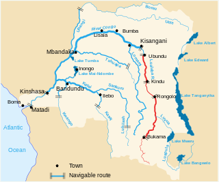
Lake Mweru is a freshwater lake on the longest arm of Africa's second-longest river, the Congo. Located on the border between Zambia and Democratic Republic of the Congo, it makes up 110 kilometres (68 mi) of the total length of the Congo, lying between its Luapula River (upstream) and Luvua River (downstream) segments.
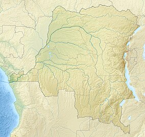
The Lualaba River flows entirely within the eastern part of Democratic Republic of the Congo. It provides the greatest streamflow to the Congo River, while the source of the Congo is recognized as the Chambeshi. The Lualaba is 1,800 kilometres (1,100 mi) long. Its headwaters are in the country's far southeastern corner near Musofi and Lubumbashi in Katanga Province, next to the Zambian Copperbelt.
Atheris katangensis, also known as the Katanga Mountain bush viper and other common names, is a species of venomous viper found in the eastern Democratic Republic of the Congo and in Zambia. No subspecies are currently recognized.
The Katanga, or Shaba, plateau is a farming and ranching region in the Democratic Republic of the Congo. Located in the southeastern Katanga Province, it is bordered by the Kundelungu and Mitumba mountain ranges from the north, Muchinga mountain range from the east, and connected to the Lunda Plateau in the south and west. it is 1220 m above sea level and is rich in copper and uranium deposits. The altitude makes it cooler than the surrounding area, with a mean annual temperature of 19-20 °C. The existence of seasonal rainfall makes Katanga Plateau a fertile arable area as well as an industrial region in DR Congo.
Articles related to the Democratic Republic of the Congo include:
The Upemba lechwe is a subspecies of antelope found only in the Upemba wetlands in the Democratic Republic of Congo. It was described in 2005, after analysis of 35 museum specimens collected in 1926 and 1947–8. Some authorities treat the Upemba lechwe as a species, K. anselli.

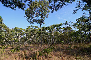
The wildlife of the Democratic Republic of the Congo includes its flora and fauna, comprising a large biodiversity in rainforests, seasonally flooded forests and grasslands.
Leptopelis parvus, also known as the Kanole forest treefrog, is a species of frog in the family Arthroleptidae. It is endemic to the Democratic Republic of the Congo and is only known from the Upemba National Park.
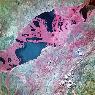
Lake Upemba is a lake in Bukama, Haut-Lomami Province, the Democratic Republic of the Congo. It, and nearby Lake Kisale, is surrounded by the Upemba Depression in Upemba National Park. The nearest town is Nyonga, and the nearest hospital is located four hours away in Kikondja.
The Central Zambezian miombo woodlands ecoregion spans southern central Africa. Miombo woodland is the predominant plant community. It is one of the largest ecoregions on the continent, and home to a great variety of wildlife, including many large mammals.

Lualaba District was a district of the pre-2015 Katanga Province in the Democratic Republic of the Congo. The district dates back to the days of the Congo Free State and the Belgian Congo. The original Lualaba District was merged into Katanga in 1910, but in 1933 a new Lualaba District was formed within Katanga. After various significant boundary changes, in 2015 the district became the western part of the present Lualaba Province.

Lake Kisale is a lake in the Democratic Republic of the Congo (DRC), in Bukama Territory, Haut-Lomami District. At about 300 square kilometres (120 sq mi) in area, it is the second largest of the lakes in the Upemba Depression, an extensive marshy area partly within the Upemba National Park.
Lake Zimbambo is a lake in the Malemba-Nkulu Territory of Haut-Lomami Province, in the southern Democratic Republic of the Congo.
The Kibara Mountains are a range in the Katanga Province of the Democratic Republic of the Congo. They are partly within the Upemba National Park.

The Kahuzi-Biega National Park is a protected area near Bukavu town in eastern Democratic Republic of the Congo. It is situated near the western bank of Lake Kivu and the Rwandan border. Established in 1970 by the Belgian photographer and conservationist Adrien Deschryver, the park is named after two dormant volcanoes, Mount Kahuzi and Mount Biega, which are within its limits. With an area of 6,000 square kilometres (2,300 sq mi), Kahuzi-Biega is one of the biggest national parks in the country. Set in both mountainous and lowland terrain, it is one of the last refuges of the rare species of Eastern lowland gorilla, an endangered category under the IUCN Red List. The park is a UNESCO World Heritage Site, inscribed in 1980 for its unique biodiversity of rainforest habitat and its eastern lowland gorillas. In 1997, it was listed on the List of World Heritage in Danger because of the political instability of the region, an influx of refugees, and increasing wildlife exploitation.

The Katanga insurgency is an ongoing rebellion by a number of rebel groups in the Democratic Republic of the Congo, some of which aim for the creation of a separate state within Katanga. While the insurgency has been active in various forms since 1963, insurgent groups have recently redoubled their efforts after the 2011 jail break that freed Gédéon Kyungu Mutanga, who commanded the majority of the Katangese separatist groups until his surrender to Congolese authorities in October 2016.
Kundelungu National Park is a national park of the Democratic Republic of the Congo, located in Haut-Katanga Province. The park was first established in 1970. It is approximately 7,600 square kilometres. The park is the site of Lofoi Falls, a 340 metres (1,120 ft) high waterfall

Haut-Lomami District was a district of the pre-2015 Katanga Province in the Democratic Republic of the Congo. The district dates back to the days of the Belgian Congo. At its greatest extent it roughly corresponded to the northern part of the current Lualaba Province and to the present Haut-Lomami Province.
Luapula-Moero District was a district of the pre-2015 Katanga Province in the Belgian Congo and Democratic Republic of the Congo. It roughly corresponded in area to the present Haut-Katanga Province.