Vale Royal

Last updated

Borough of Vale Royal
CheshireValeRoyal.png
Shown within Cheshire
History
  Origin Northwich Urban District
Winsford Urban District
Northwich Rural District
Runcorn Rural District (part of)
  Created1 April 1974
  Abolished31 March 2009
  Succeeded by Cheshire West and Chester
Status Non-metropolitan district
ONS code 13UH
   HQ Winsford

Vale Royal was, from 1974 to 2009, a local government district with borough status in Cheshire, England. It contained the towns of Northwich, Winsford and Frodsham.

Contents

History

The district was created on 1 April 1974 under the Local Government Act 1972 covering the area of three former districts and part of a fourth, which were abolished at the same time: [1]

The district took its name from Vale Royal Abbey, formerly one of the largest in England, which was situated near the village of Whitegate near the centre of the district. The name was suggested in 1972 by a joint committee of the previous district councils, on the basis of the historic use of the name for the general area of the new district. [2] [3] The district was granted borough status on 5 May 1988, allowing the chairman of the council to take the title of mayor. [4]

In 2006 the Department for Communities and Local Government considered reorganising Cheshire's administrative structure as part of the 2009 structural changes to local government in England. The decision to merge Vale Royal with the districts of Chester and Ellesmere Port and Neston to create a single unitary authority was announced on 25 July 2007, following a consultation period in which a proposal to create a single Cheshire unitary authority was rejected. [5]

Vale Royal was abolished on 31 March 2009, with the area becoming part of the new unitary authority of Cheshire West and Chester from 1 April 2009. [6]

Civil parishes

Civil parishes within Vale Royal (2009). Vale royal parishes.png
Civil parishes within Vale Royal (2009).

The district comprised the following civil parishes:

Political control

The first elections to the council were held in 1973, initially operating as a shadow authority until the new arrangements came into effect on 1 April 1974. Political control of the council from 1974 until its abolition in 2009 was held by the following parties: [7] [8]

Party in controlYears
No overall control 1974–1991
Labour 1991–2003
No overall control 2003–2007
Conservative 2007–2008
No overall control 2008–2009

Leadership

The leaders of the council from 1988 were:

CouncillorPartyFromTo
Marie Birkenhead Conservative 5 May 1988
Arthur Neil [9] Labour align=right|5 May 198811 May 1989
David Broster [10] Conservative align=right|11 May 198910 May 1990
Bernard Burton [11] Conservative align=right|10 May 19901991
Arthur Neil [12] Labour 1991Apr 2000
Bob Mather [13] Labour Apr 2000May 2003
Keith Musgrave [14] Conservative May 2003May 2007
Les Ford Conservative May 200731 Mar 2009

Composition

The political composition of the council at its abolition in 2009 was:

PartyCouncillors
Conservative26
Labour17
Liberal Democrat11
Weaverham Independents3

Premises

Wyvern House, The Drumber, Winsford: Council headquarters 1990-2009 Wyvern House - geograph.org.uk - 1800344.jpg
Wyvern House, The Drumber, Winsford: Council headquarters 1990–2009

Until 1990 the council operated from the various offices it had inherited from its predecessors, being Whitehall in Hartford (from Northwich Rural District Council), the Council House in Northwich (from Northwich Urban District Council), Castle Park House in Frodsham (from Runcorn Rural District Council), and Over Hall in Winsford (from Winsford Urban District Council). [15] [16] In 1990 the council consolidated its offices into a new purpose-built headquarters called Wyvern House on The Drumber in Winsford. [17] Wyvern House was formally opened by Princess Margaret on 19 July 1991. [18] [19] Since the council's abolition in 2009, Wyvern House has been used as one of the offices of its successor, Cheshire West and Chester Council. [20]

Council elections

By-election results

Castle By-Election 25 July 1996
PartyCandidateVotes%±%
Labour 53561.9
Conservative 20123.3
Liberal Democrats 12814.8
Majority33438.6
Turnout 86418.0
Labour hold Swing
Vale Royal By-Election 24 October 1996
PartyCandidateVotes%±%
Labour 63761.9
Liberal Democrats 21821.2
Conservative 17416.9
Majority41940.7
Turnout 1,02921.0
Labour hold Swing
Davenham and Moulton By-Election 10 April 1997
PartyCandidateVotes%±%
Liberal Democrats 69542.3
Labour 48629.6
Conservative 46128.1
Majority20912.7
Turnout 1,64233.6
Liberal Democrats gain from Labour Swing
Tarporley By-Election 10 April 1997
PartyCandidateVotes%±%
Conservative 37258.3
Labour 13821.6
Liberal Democrats 12820.1
Majority23436.7
Turnout 63830.7
Conservative hold Swing
Northwich Witton By-Election 7 June 2001
PartyCandidateVotes%±%
Labour 1,41360.5
Conservative 45619.5
Liberal Democrats 32013.7
Independent 1466.3
Majority95741.0
Turnout 2,335
Labour hold Swing
Kingsley By-Election 25 September 2003
PartyCandidateVotes%±%
Conservative 36453.2+14.3
Liberal Democrats 18727.3-29.3
Labour 13319.4+14.9
Majority17725.9
Turnout 68440.7
Conservative gain from Liberal Democrats Swing
Frodsham South By-Election 4 March 2004
PartyCandidateVotes%±%
Conservative 26347.9-0.6
Liberal Democrats 16630.2-1.5
Labour 12021.9+2.1
Majority9717.7
Turnout 54931.3
Conservative hold Swing
Lostock and Wincham By-Election 26 August 2004
PartyCandidateVotes%±%
Conservative 41446.1+21.3
Liberal Democrats 27430.5-17.8
Labour 18520.6-6.3
Independent 262.9+2.9
Majority14015.6
Turnout 89926.9
Conservative gain from Liberal Democrats Swing
Winsford Swanlow By-Election 20 January 2005
PartyCandidateVotes%±%
Liberal Democrats Brandon Parkey32648.9-20.3
Conservative 18327.5+13.4
Labour 15723.6+6.9
Majority14321.4
Turnout 66619.5
Liberal Democrats hold Swing
Winsford Verdin By-Election 20 January 2005
PartyCandidateVotes%±%
Liberal Democrats Peter Gannon33656.4+18.7
Labour 18831.5-8.6
Conservative 7212.1-12.1
Majority14824.9
Turnout 59612.0
Liberal Democrats gain from Labour Swing
Leftwich and Kingsmead By-Election 9 February 2006
PartyCandidateVotes%±%
Labour Helen Burder33436.2+3.4
Liberal Democrats Glyn Roberts29632.1+2.5
Conservative Kathryn Birtwistle29331.7-5.9
Majority384.1
Turnout 92316.0
Labour hold Swing
Leftwich and Kingsmead By-Election 1 May 2008
PartyCandidateVotes%±%
Conservative Helen Weltman85554.8+24.5
Labour Paul Dolan38324.5-3.4
Liberal Democrats Glyn Roberts32320.7+3.4
Majority47230.2
Turnout 1,561
Conservative hold Swing

Related Research Articles

<span class="mw-page-title-main">Cheshire</span> County of England

Cheshire is a ceremonial county in North West England. It is bordered by Merseyside to the north-west, Greater Manchester to the north-east, Derbyshire to the east, Staffordshire to the south-east, and Shropshire to the south; to the west it is bordered by the Welsh counties of Flintshire and Wrexham, and has a short coastline on the Dee Estuary. Warrington is the largest settlement, and the city of Chester is the county town.

<span class="mw-page-title-main">Frodsham</span> Town and civil parish in England

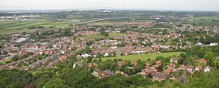
Frodsham is a market town, civil parish, and electoral ward in the unitary authority of Cheshire West and Chester and the ceremonial county of Cheshire, England. Its population in 2021 was 9,300. It is 16 miles (26 km) south of Liverpool and 28 miles (45 km) southwest of Manchester. The River Weaver runs to its northeast and on the west it overlooks the estuary of the River Mersey. The A56 road and the Chester–Manchester railway line pass through the town, and the M56 motorway passes to the northwest.

<span class="mw-page-title-main">Northwich</span> Human settlement in England

Northwich is a market and port town and civil parish in the unitary authority of Cheshire West and Chester in the ceremonial county of Cheshire, England. It lies in the heart of the Cheshire Plain, at the confluence of the rivers Weaver and Dane. The town is about 18 miles (29 km) east of Chester, 15 miles (24 km) south of Warrington, and 19 miles (31 km) south of Manchester.

<span class="mw-page-title-main">Civil parishes in Cheshire</span>

A civil parish is a country subdivision, forming the lowest unit of local government in England. There are 333 civil parishes in the ceremonial county of Cheshire, most of the county being parished. Cheshire East unitary authority is entirely parished. At the 2001 census, there were 565,259 people living in 332 parishes, accounting for 57.5 per cent of the county's population.

<span class="mw-page-title-main">Winsford</span> Town in Cheshire, England

Winsford is a town and civil parish in the unitary authority of Cheshire West and Chester and the ceremonial county of Cheshire, England, on the River Weaver south of Northwich and west of Middlewich. It grew around the salt mining industry after the river was canalised in the 18th century, allowing freight to be conveyed northwards to the Port of Runcorn on the River Mersey. The town of Winsford has an estimated population of 35,500 in 2024.

<span class="mw-page-title-main">Eddisbury (UK Parliament constituency)</span> Parliamentary constituency in the United Kingdom, 1885 to 1950 and 1983 onwards

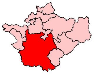
Eddisbury is a constituency in Cheshire represented in the House of Commons of the UK Parliament since 2019 by Edward Timpson, a Conservative.

<span class="mw-page-title-main">Tatton (UK Parliament constituency)</span> Parliamentary constituency in the United Kingdom

Tatton is a constituency in Cheshire represented in the House of Commons of the UK Parliament since 2017 by Esther McVey, a Conservative.

<span class="mw-page-title-main">Weaver Vale (UK Parliament constituency)</span> Parliamentary constituency in the United Kingdom, 1997 onwards

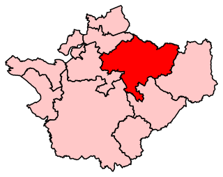
Weaver Vale is a constituency in Cheshire represented in the House of Commons of the UK Parliament since 2017 by Mike Amesbury, a member of the Labour Party.

<span class="mw-page-title-main">Cheshire County Council</span> Former local authority in England

Cheshire County Council was the county council of Cheshire. Founded on 1 April 1889, it was officially dissolved on 31 March 2009, when it and its districts were superseded by two unitary authorities; Cheshire West and Chester and Cheshire East.

Mid Cheshire is a former two-member United Kingdom parliamentary constituency which existed in the 19th century.

<span class="mw-page-title-main">Runcorn (UK Parliament constituency)</span> Parliamentary constituency in the United Kingdom, 1950–1983

Runcorn was a parliamentary constituency centred on the town of Runcorn in Cheshire. It returned one Member of Parliament (MP) to the House of Commons of the Parliament of the United Kingdom, elected by the first past the post system.

<span class="mw-page-title-main">Northwich (UK Parliament constituency)</span> Parliamentary constituency in the United Kingdom, 1885–1983

Northwich was a constituency in Cheshire which returned one Member of Parliament (MP) to the House of Commons of the Parliament of the United Kingdom from 1885 until it was abolished for the 1983 general election.

<span class="mw-page-title-main">Cheshire West and Chester</span> Borough in England

Cheshire West and Chester is a unitary authority area with borough status in Cheshire, England. It was established on 1 April 2009 as part of the 2009 local government changes, by virtue of an order under the Local Government and Public Involvement in Health Act 2007. It superseded the boroughs of Ellesmere Port and Neston, Vale Royal and the City of Chester; its council assumed the functions and responsibilities of the former Cheshire County Council within its area. The remainder of ceremonial Cheshire is composed of Cheshire East, Halton and Warrington. Cheshire West and Chester has three key urban areas: Chester, Ellesmere Port and Northwich/Winsford.

<span class="mw-page-title-main">Northwich Rural District</span>

Northwich Rural District was a rural district surrounding, but not including the towns of Northwich and Winsford in Cheshire, which were separate urban districts. It was created in 1894 from the Northwich Rural Sanitary District.

<span class="mw-page-title-main">Cheshire West and Chester Council</span> UK local government administration unit from 2009

Cheshire West and Chester Council is the local authority for Cheshire West and Chester. It is a unitary authority created on 1 April 2009, succeeding the non-metropolitan districts of Chester City Council, Ellesmere Port and Neston Borough Council, and Vale Royal Borough Council, and the non-metropolitan county of Cheshire County Council. The council was first elected on 1 May 2008, a year before coming into its legal powers on 1 April 2009.

<span class="mw-page-title-main">2015 Cheshire West and Chester Council election</span>

The 2015 Cheshire West and Chester Council election took place on 7 May 2015, electing members of Cheshire West and Chester Council in England. This was on the same day as other local elections across the country as well as the general election.

<span class="mw-page-title-main">2019 Cheshire West and Chester Council election</span>

The 2019 Cheshire West and Chester Council election took place on 2 May 2019 to elect members of Cheshire West and Chester Council in England. This was on the same day as other local elections. Five fewer seats were contested because of boundary changes. No party gained overall control. The Labour Party gained a seat but lost control of the council; the Conservatives lost 8 seats, while the Independents gained 4, the Liberal Democrats gained 2, and the Green Party gained one.

The ceremonial county of Cheshire, which comprises the unitary authorities of Cheshire East, Cheshire West and Chester, Halton and Warrington, has returned 11 MPs to the UK Parliament since 1997.

References

  1. "The English Non-metropolitan Districts (Definition) Order 1972", legislation.gov.uk , The National Archives, SI 1972/2039, retrieved 6 September 2022
  2. "Vale Royal as new name for District 4?". Crewe Chronicle. 7 December 1972. p. 25. Archived from the original on 22 September 2023. Retrieved 6 September 2022.
  3. "The English Non-metropolitan Districts (Names) Order 1973", legislation.gov.uk , The National Archives, SI 1973/551, retrieved 6 September 2022
  4. "Bulletins of Change 1987–1988" (PDF). Database of Local Government Orders. Local Government Boundary Commission for England. Archived (PDF) from the original on 20 March 2022. Retrieved 6 September 2022.
  5. BBC News, 25 July 2007 – County split into two authorities. Archived 7 January 2009 at the Wayback Machine Retrieval Date: 25 July 2007.
  6. "Cheshire (Structural Changes) Order 2008". Archived from the original on 17 May 2009. Retrieved 4 April 2009.
  7. "Compositions calculator". The Elections Centre. Archived from the original on 10 August 2022. Retrieved 10 August 2022.
  8. Teale, Andrew. "Local Election Results 2007: Vale Royal". Local Elections Archive Project. Archived from the original on 7 May 2022. Retrieved 6 September 2022.
  9. "Vale Royal's first Labour leader" . Runcorn Weekly News. 12 May 1988. p. 11. Retrieved 8 August 2023 via Newspaper.com.
  10. "Labour loses its grasp after mayor change". Northwich Chronicle. 17 May 1989. p. 27. Retrieved 8 August 2023 via Newspapers.com.
  11. "Vale Royal elects its officers". Runcorn Weekly News. 17 May 1990. p. 12. Archived from the original on 11 August 2023. Retrieved 8 August 2023 via Newspapers.com.
  12. "It's a tough job - but worth it to help people". Warrington Guardian. 28 April 2000. Retrieved 6 September 2022.
  13. "Executive Group". Vale Royal Borough Council. Archived from the original on 2 June 2000. Retrieved 6 September 2022.
  14. Wilson, James (26 May 2007). "Party ditches council leader". Northwich Guardian. Retrieved 6 September 2022.
  15. "Council bid for HQ". Winsford Chronicle. 3 December 1987. p. 6. Archived from the original on 22 September 2023. Retrieved 6 September 2022.
  16. "Cheshire County Council". London Gazette (51747): 6318. 26 May 1989. Retrieved 6 September 2022.
  17. "The Council". Vale Royal Borough Council. Archived from the original on 23 April 1999. Retrieved 6 September 2022.
  18. "Vale Royal office opening". Runcorn Weekly News. 11 July 1991. p. 12. Archived from the original on 22 September 2023. Retrieved 6 September 2022.
  19. "Princess of smiles on tour". Crewe Chronicle. 24 July 1991. p. 1. Archived from the original on 22 September 2023. Retrieved 6 September 2022.
  20. "Customer service centres". Cheshire West and Chester Council. Archived from the original on 6 September 2022. Retrieved 6 September 2022.
  21. legislation.gov.uk - The District of Vale Royal (Electoral Arrangements) Order 1976 Archived 7 September 2022 at the Wayback Machine . Retrieved on 19 November 2015.
  22. The Macclesfield and Vale Royal (Areas) Order 1982
  23. legislation.gov.uk - The Cheshire (District Boundaries) Order 1988. Retrieved on 6 November 2015.
  24. legislation.gov.uk - The Borough of Vale Royal (Electoral Changes) Order 1998 Archived 7 September 2022 at the Wayback Machine . Retrieved on 4 October 2015.

53°15′N2°36′W / 53.250°N 2.600°W / 53.250; -2.600