Stanthorne

Last updated

Stanthorne
Stanthorne Hall - geograph.org.uk - 444616.jpg
Stanthorne Hall
Cheshire UK location map.svg
Red pog.svg
Stanthorne
Location within Cheshire
Population153 (2011 census)
OS grid reference SJ688660
Civil parish
District
Shire county
Region
Country England
Sovereign state United Kingdom
Post town MIDDLEWICH
Postcode district CW10
Dialling code 01606
Police Cheshire
Fire Cheshire
Ambulance North West
UK Parliament
List of places
UK
England
Cheshire
53°11′24″N2°27′58″W / 53.190°N 2.466°W / 53.190; -2.466

Stanthorne is a village and former civil parish, now in the parish of Stanthorne and Wimboldsley, in the Cheshire West and Chester district, in the ceremonial county of Cheshire, England, 2 miles west of Middlewich. The A54 runs through the village, connecting it to the railway station at Winsford. [1] At the 2011 census, it had a population of 153. [2]

Contents

History

Stanthorne was a township in the ancient parish of Davenham and eventually became a civil parish in 1866. In the 1870s, Stanthorne was described as "a township in Davenham parish, Cheshire; 1 mile WNW of Middlewich. Acres, 1,062. Real property, £2,438. Pop., 161. Houses, 27." [3] In 1936, a few boundary changes occurred, resulting in the addition of a few acres of Clive and Kinderton, but the loss of the 358 acres of Winsford. [4]

On 1 April 2015, the civil parish amalgamated with Wimboldsley to form "Stanthorne and Wimboldsley". [5] [6] [7]

The buildings within Stanthorne include eleven Grade II listed buildings. Stanthorne Hall was built between 1804 and 1807 by Richard Dutton and is a country house to the west of the village. Another Grade II listed building is Stanthorne Mill on the River Wheelock. [8] This is an ancient mill site and some of the mill machinery is still present in the interior. [9]

Population and housing

Population of Stanthorne between 1881 and 2011 Population graph for Stanthorne.jpg
Population of Stanthorne between 1881 and 2011

In 1881, Stathorne had a population of 193. [10] The population stayed at a steady point up until after 1921 when there was a dramatic increase resulting in an overall population of 290. However, in the years to follow the population steadily decreased and reached an all-time low of 136 in 1951. Since 1951 the population of Stanthorne has not increased or decreased severely. The gender ratio of Stanthorne at the present time is very equal, with 82 males and 71 females. [11]

The majority of houses in Stanthorne are detached. [12] A greater percentage of the population live as a couple with no dependent children, only 41 people out of the 153 do not live as a couple in Stanthorne. The population density of Stanthorne is 0.5 people per hectare. [13]

Geography

River Wheelock River Wheelock - geograph.org.uk - 444618.jpg
River Wheelock

The River Wheelock runs through the civil parish of Stanthorne. "Wheelock" is derived from the Old Welsh language and means 'winding river'. [14] The river is very small and drains water from the area of Sandbach and Crewe. [15] The river is very popular for fishing in the area and attracts local and distant fishermen.

The soil is made up of partly sand and partly clay. [16]

Transport

In January 2013 proposals were brought forward for the nearby towns of Winsford and Middlewich to be bisected by a new High Speed Two rail line. The proposed route would cut through the parish of Stanthorne. [17] Many resident associations and various wildlife organisations are against the new line as it could cause high levels of disruption not just socially but also environmentally in the local area. So far no final decision has been made on the building of the new line. [18]

Notable people

Charles Dickens once stayed at Stanthorne Hall during the 1800s, as this is around the time the author wrote Great Expectations it is believed that the character of Miss Havisham was inspired by a spinster who lived in Stanthorne at the time. [19] It is thought that a young woman who lived in Stanthorne lodge unmarried and alone was very similar to the character of Miss Havisham. [20] However, there is much controversy over the story and many competing claims argue that the inspiration originated elsewhere.

See also

Related Research Articles

<span class="mw-page-title-main">Northwich</span> Human settlement in England

Northwich is a town and civil parish in the unitary authority of Cheshire West and Chester in the ceremonial county of Cheshire, England. It lies in the heart of the Cheshire Plain, at the confluence of the rivers Weaver and Dane. The town is about 18 miles (29 km) east of Chester, 15 miles (24 km) south of Warrington, and 19 miles (31 km) south of Manchester.

<span class="mw-page-title-main">Middlewich</span> Town in Cheshire, England

Middlewich is a town in the unitary authority of Cheshire East and the ceremonial county of Cheshire, England, 19.2 miles (30.9 km) east of Chester, 2.9 miles (4.7 km) east of Winsford, 5.3 miles (8.5 km) southeast of Northwich and 4.7 miles (7.6 km) northwest of Sandbach. The population at the 2011 Census was 13,595. Middlewich, with Northwich and Winsford, forms part of the Central Cheshire conurbation, with an estimated 2023 population of 130,000.

<span class="mw-page-title-main">Civil parishes in Cheshire</span>

A civil parish is a country subdivision, forming the lowest unit of local government in England. There are 333 civil parishes in the ceremonial county of Cheshire, most of the county being parished. Cheshire East unitary authority is entirely parished. At the 2001 census, there were 565,259 people living in 332 parishes, accounting for 57.5 per cent of the county's population.

<span class="mw-page-title-main">Davenham</span> Human settlement in England

Davenham is a village and civil parish in Cheshire, England. It is part of the Borough of Cheshire West and Chester. It had a population of 2,745 at the 2011 census. It is in the centre of the Cheshire Plain near both the River Dane and River Weaver.

<span class="mw-page-title-main">River Croco</span> River in Cheshire, England

Middlewich is one of the Wich towns in Cheshire, England.

<span class="mw-page-title-main">Utkinton</span> Human settlement in England

Utkinton is a village and former civil parish, now in the parishes of Utkinton and Cotebrook, in the unitary authority area of Cheshire West and Chester and the ceremonial county of Cheshire, England. It is approximately 2 miles (3.2 km) north of Tarporley, 8 miles (13 km) west of Winsford and 9 miles (14 km) east of Chester. The upper part of Utkinton is known as 'Quarry Bank'. Utkinton is at the heart of the local farming community. The area is also on the Sandstone Trail.

<span class="mw-page-title-main">Wimboldsley</span> Human settlement in England

Wimboldsley is a village and former civil parish, now in the parish of Stanthorne and Wimboldsley, in the Cheshire West and Chester district, in the ceremonial county of Cheshire, England, 2 miles south of Middlewich. The population of the parish at the 2011 census was 153.

<span class="mw-page-title-main">Cheshire West and Chester</span> Borough in England

Cheshire West and Chester is a borough with unitary authority status in Cheshire, England. It was established on 1 April 2009 as part of the 2009 local government changes, by virtue of an order under the Local Government and Public Involvement in Health Act 2007. It superseded the boroughs of Ellesmere Port and Neston, Vale Royal and the City of Chester; its council assumed the functions and responsibilities of the former Cheshire County Council within its area. The remainder of ceremonial Cheshire is composed of Cheshire East, Halton and Warrington.

<span class="mw-page-title-main">Cholmondeston</span> Village in Cheshire, England

Cholmondeston is a village and civil parish in the unitary authority of Cheshire East and the ceremonial county of Cheshire, England. The village lies 5 miles (8 km) to the northwest of Nantwich. Nearby villages include Aston juxta Mondrum, Barbridge, Calveley and Wettenhall. The Middlewich Branch of the Shropshire Union Canal and the Crewe–Chester railway line run through the civil parish. The area is predominantly rural, with a total population of around 150 in 2001, increasing to 175 at the 2011 Census.

<span class="mw-page-title-main">Minshull Vernon</span> Human settlement in England

Minshull Vernon is a hamlet and civil parish in the unitary authority of Cheshire East and the ceremonial county of Cheshire, England. The hamlet lies 3 miles (5 km) to the north west of Crewe, south east of Winsford and south west of Middlewich. The parish also includes the small settlements of Bradfield Green, Eardswick, Hoolgrave, Minshull Hill, Walley's Green and Weaver Bank. The total population of the civil parish is somewhat over 200, measured at 391 in the Census 2011. Nearby villages include Church Minshull, Warmingham and Wimboldsley.

<span class="mw-page-title-main">Warmingham</span> Human settlement in England

Warmingham is a village and civil parish in the unitary authority of Cheshire East and ceremonial county of Cheshire, England, on the River Wheelock, 3.25 miles (5.23 km) north of Crewe, 3.25 miles (5.23 km) south of Middlewich and 3.25 miles (5.23 km) miles west of Sandbach. The parish also includes the small settlement of Lane Ends, with a total population of just under 250. Nearby villages include Minshull Vernon, Moston and Wimboldsley.

<span class="mw-page-title-main">Occlestone Green</span> Human settlement in England

Occlestone Green is a small rural settlement in the civil parish of Stanthorne and Wimboldsley, the unitary authority of Cheshire West and Chester and the ceremonial county of Cheshire, England. Nearby settlements include the villages of Wimboldsley, Warmingham and Walley's Green. The nearest town is Middlewich.

<span class="mw-page-title-main">Mickle Trafford</span> Human settlement in England

Mickle Trafford is a village and former civil parish, now in the parish of Mickle Trafford and District, in the unitary authority area of Cheshire West and Chester and the ceremonial county of Cheshire, England. It includes the area known as Plemstall. The A56 road from Chester to Warrington passes through the village and the Chester-Warrington railway line passes immediately to its east.

<span class="mw-page-title-main">Northwich Rural District</span>

The Verdin Baronetcy, of the Brocklehurst in the Parish of Davenham and of Wimboldsley in the Parish of Middlewich, both in the County Palatine of Chester, was a title in the Baronetage of the United Kingdom. It was created on 24 July 1896 for Sir Joseph Verdin. In 1895, he donated money to set up the Verdin Technical Schools in Winsford and Northwich, Cheshire. The title became extinct on his death in 1920.

Stanthorne is a former civil parish, now in the parish of Stanthorne and Wimboldsley, in Cheshire West and Chester, England. It contains eleven buildings that are recorded in the National Heritage List for England as designated listed buildings, all of which are listed at Grade II. This grade is the lowest of the three gradings given to listed buildings and is applied to "buildings of national importance and special interest". The parish is entirely rural, and this is reflected in the nature of many of the listed buildings. The River Wheelock, the Shropshire Union Canal, and its Middlewich Branch pass through the parish, and there are listed buildings associated with all three waterways.

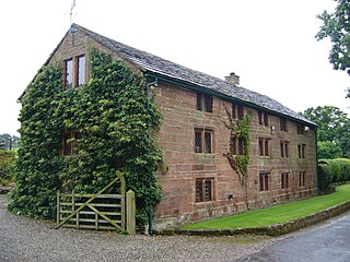
Wimboldsley is a former civil parish, now in the parish of Stanthorne and Wimboldsley, in Cheshire West and Chester, England. It contains seven buildings that are recorded in the National Heritage List for England as designated listed buildings. The parish is completely rural, and the Middlewich Branch of the Shropshire Union Canal passes through it. The listed buildings consist of three bridges crossing the canal, a country house and its reset gate-piers, and two farm buildings.

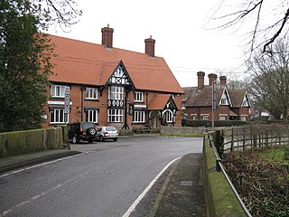
Byley is a civil parish in Cheshire West and Chester, England. It contains three buildings that are recorded in the National Heritage List for England as designated listed buildings, all of which are at Grade II. This grade is the lowest of the three gradings given to listed buildings and is applied to "buildings of national importance and special interest". Apart from the small village of Byley, the parish is entirely rural. The listed buildings consist of the village church, and two houses.

References

  1. "Google maps".
  2. "Stanthorne (Parish): Key Figures for 2011 Census: Key Statistics". Neighbourhood Statistics. Office for National Statistics. Retrieved 4 February 2013.
  3. Wilson, John (1870–72). Imperial Gazetteer of England and Wales (1st ed.). Edinburgh: A.Fullarton and Co. Retrieved 4 February 2013.
  4. Langston, Brett. "Cheshire Towns & Parishes". Genuki. UKBMD.
  5. The Cheshire West and Chester Borough Council (Reorganisation of Community Governance) (Stanthorne and Wimboldsley) Order 2015 (PDF), Cheshire West and Chester Council, 30 March 2015, retrieved 8 October 2016
  6. "STANTHORNE". GENUKI. Retrieved 28 April 2018.
  7. "Cheshire West and Chester Registration District". UKBMD. Retrieved 2 September 2023.
  8. "Stanthorne Mill – Middlewich". British Listed Buildings. English Heritage.
  9. Historic England. "Details from listed building database (1329815)". National Heritage List for England . Retrieved 30 April 2013.
  10. "Stanthorne CP/Tn through time". Vision of Britain. University of Portsmouth.
  11. "Neighbourhood Statistics". Office for National Statistics.
  12. "Neighbourhood Statistics". Office for National Statistics.
  13. "Neighbourhood Statistics". Population Density. Office for National Statistics.
  14. Dodgson, J. McN. (1970). p. 38.{{cite book}}: Missing or empty |title= (help)
  15. "Carp Info".
  16. "British History Online".
  17. Matthew Taylor (31 January 2013). "£33billion HS2 to cut between Middlewich and Winsford". Middlewich Guardian.
  18. Matthew Taylor (7 February 2013). "MP backs HS2". Winsford Guardian.
  19. Dutton, Edward. "Charles Dickens and Stanthorne Hall near Middlewich – Putting a Local Rumour to Rest". Cheshire Magazine. C.C. Publishing.
  20. Langley, Alan. "Winsford Guardian".

Commons-logo.svg Media related to Stanthorne at Wikimedia Commons