Cheshire, archaically the County Palatine of Chester, is a county in northwest England. It is bordered by Merseyside and Greater Manchester to the north, Derbyshire to the east, Staffordshire and Shropshire to the south, and the Welsh local authorities of Flintshire and Wrexham to the west. Cheshire's county town is Chester, while its largest town by population is Warrington. Other major towns include Crewe, Ellesmere Port, Macclesfield, Northwich, Runcorn, Widnes, Wilmslow, and Winsford.

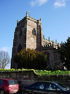
Frodsham is a market town, civil parish and electoral ward in the unitary authority of Cheshire West and Chester and the ceremonial county of Cheshire, England. Its population was 8,982 in 2001, increasing to 9,077 at the 2011 Census. It is approximately 3 miles (5 km) south of Runcorn, 16 miles (26 km) south of Liverpool, and 28 miles (45 km) southwest of Manchester. The River Weaver runs to its northeast and on the west it overlooks the estuary of the River Mersey. The A56 road and the Chester–Manchester railway line pass through the town, and the M56 motorway passes to the northwest.
Tattenhall is a village and former civil parish, now in the parish of Tattenhall and District, 8 miles (13 km) south-east of Chester, in the unitary authority of Cheshire West and Chester and the ceremonial county of Cheshire, England. In the 2001 census, the population was recorded as 1,986, increasing to 2,079 by the 2011 census. The civil parish was abolished in 2015 to form Tattenhall and District.

Upton-by-Chester is a civil parish and a large suburb on the outskirts of Chester, in the unitary authority of Cheshire West and Chester and the ceremonial county of Cheshire, England. It includes the villages of Upton and Upton Heath.
Tarvin is a village in the unitary authority of Cheshire West and Chester and the ceremonial county of Cheshire, England. It had a population of 2,693 people at the 2001 UK census, rising to 2,728 at the 2011 Census, and the ward covers about 17 square miles (44 km2).
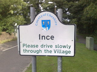
Ince is a village and civil parish in the unitary authority of Cheshire West and Chester and the ceremonial county of Cheshire, England. It is situated immediately to the east of the Stanlow Oil Refinery. It shares Ince & Elton railway station with the village of Elton, which it runs into.

Bickley is a former civil parish, now in the parish of No Man's Heath and District, in the unitary authority of Cheshire West and Chester and ceremonial county of Cheshire, England. According to the 2001 Census it had a population of 498, reducing slightly to 481 at the 2011 census. The parish included the villages of Bickley Town and Bickley Moss. The civil parish was abolished in 2015 to form No Man's Heath and District.
Stretton is a hamlet and civil parish in the unitary authority of Cheshire West and Chester and the ceremonial county of Cheshire, England. The small, rural parish also includes the hamlet of Wetreins Green. It is near the Welsh border, approximately thirteen miles south of Chester and about eight miles east of Wrexham in Wales.
Malpas is an ancient market town and a civil parish in the unitary authority of Cheshire West and Chester and the ceremonial county of Cheshire, England. Malpas is now referred to as a village after losing its town status. It lies near the borders with Shropshire and Wales, and had a population of 1,673 at the 2011 census.

Christleton is a village and civil parish on the outskirts of Chester, in the unitary authority of Cheshire West and Chester and the ceremonial county of Cheshire, England. The Shropshire Union Canal passes through the village.

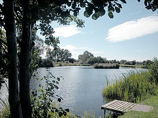
Little Budworth is a civil parish and village between Winsford and Chester, in the unitary authority of Cheshire West and Chester and the ceremonial county of Cheshire, England. The population of the civil parish taken at the 2011 census was 594. It is primarily known as the location of the Oulton Park motor racing circuit.
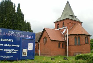
Saughall is a village and former civil parish, in the unitary authority of Cheshire West and Chester and the ceremonial county of Cheshire, England. Located between Shotwick and Blacon, it is approximately 4.8 km (3.0 mi) north west of Chester and 1.8 km (1.1 mi) from Sealand across the Welsh border. The civil parish was abolished on 1 April 2015 to form Saughall and Shotwick Park, with parts also incorporated into the parish of Puddington and the unparished area of Chester.
Ledsham is a village and civil parish in the unitary authority of Cheshire West and Chester and the ceremonial county of Cheshire, England. The civil parish includes parts of the hamlets of Badger's Rake and Two Mills. It is located on the Wirral Peninsula, approximately 10 km (6.2 mi) to the north of the city of Chester and 6 km (3.7 mi) to the west of Ellesmere Port.

Brindley is a village and civil parish in Cheshire, England. The village lies 3¾ miles to the west of Nantwich. The parish also includes the settlements of Brindley Lea, Ryders Bank and part of Radmore Green, with a total population of about 150. Nearby villages include Barbridge, Burland, Haughton and Faddiley.

Calveley is a village and civil parish in the unitary authority of Cheshire East and the ceremonial county of Cheshire, England. The village lies 5½ miles to the north west of Nantwich. The parish also includes parts of the settlements of Barrets Green and Wardle Bank. The total population is 280 people. The area is largely agricultural and includes a short stretch of the Shropshire Union Canal. There is an Anglican parish church, a primary school and a public house. Nearby villages include Alpraham, Bunbury, Haughton and Wardle.

Stoke is a civil parish in the unitary authority of Cheshire East and the ceremonial county of Cheshire, England. The parish is predominantly rural with a total population of around 200, measured with the inclusion of Hurleston at 324 in the 2011 Census. The largest settlement is Barbridge, which lies 3½ miles to the north west of Nantwich. The parish also includes the small settlements of Stoke Bank and Verona. Nearby villages include Aston juxta Mondrum, Burland, Calveley, Haughton, Rease Heath and Wardle.
Warmingham is a village and civil parish in the unitary authority of Cheshire East and the ceremonial county of Cheshire, England. The village lies on the River Wheelock, 3.25 miles (5.23 km) to the north of Crewe, 3.25 miles (5.23 km) to the south of Middlewich and 3.25 miles (5.23 km) miles to the west of Sandbach. The parish also includes the small settlement of Lane Ends, with a total population of just under 250. Nearby villages include Minshull Vernon, Moston and Wimboldsley.
Mickle Trafford is a village and former civil parish, now in the parish of Mickle Trafford and District, in the unitary authority of Cheshire West and Chester and the ceremonial county of Cheshire, England. It includes the area known as Plemstall. The A56 road from Chester to Warrington passes through the village and the Chester-Warrington railway line passes immediately to its east. The civil parish was abolished in 2015 to form Mickle Trafford and District, part of it also went to Guilden Sutton.
Sir Eynion de Tilston was a Norman knight and first lord of the manor of Tilston in the English county of Cheshire.
Poulton is a settlement in Cheshire West and Chester. The area, which was a former civil parish until being merged into the combined parish of Poulton and Pulford in 2015, is in the ceremonial county of Cheshire in England. In 2001 census it had a recorded population of 92.

