Tattenhall is a village and former civil parish, now in the parish of Tattenhall and District, 8 miles (13 km) south-east of Chester, in the unitary authority area of Cheshire West and Chester and the ceremonial county of Cheshire, England. In the 2001 census, the population was recorded as 1,986, increasing to 2,079 by the 2011 census.

Chester was a non-metropolitan local government district of Cheshire, England from 1974 to 2009. It had the status of a city and a borough, and the local authority was called Chester City Council.

A civil parish is a country subdivision, forming the lowest unit of local government in England. There are 333 civil parishes in the ceremonial county of Cheshire, most of the county being parished. Cheshire East unitary authority is entirely parished. At the 2001 census, there were 565,259 people living in 332 parishes, accounting for 57.5 per cent of the county's population.
Malpas is a market town and a civil parish in the unitary authority of Cheshire West and Chester and the ceremonial county of Cheshire, England. It lies near the borders with Shropshire and Wales, and had a population of 1,673 at the 2011 census.

Tarvin was, from 1894 to 1974, a rural district in the administrative county of Cheshire, England. The district was named after the village of Tarvin, and saw considerable boundary changes throughout its life.
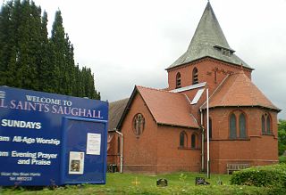
Saughall is a village and former civil parish in the unitary authority area of Cheshire West and Chester and the ceremonial county of Cheshire, England. Located between Shotwick and Blacon, it is approximately 4.8 km (3.0 mi) north west of Chester and 1.8 km (1.1 mi) from Sealand across the Welsh border.

Brassey Green is a small rural village near Tarporley, in Tiverton and Tilstone Fearnall civil parish, within the unitary authority of Cheshire West and Chester and the ceremonial county of Cheshire, England.

Calveley is a village and former civil parish, now in the parish of Alpraham and Calveley, in the unitary authority area of Cheshire East and the ceremonial county of Cheshire, England. The village lies 5½ miles to the north west of Nantwich. The parish also includes parts of the settlements of Barrets Green and Wardle Bank. The total population is 280 people. The area is largely agricultural and includes a short stretch of the Shropshire Union Canal. There is an Anglican parish church, a primary school and a public house. Nearby villages include Alpraham, Bunbury, Haughton and Wardle. In 2011 the parish had a population of 280.

Hapsford is a village and former civil parish, now in the parish of Dunham-on-the-Hill and Hapsford, in the unitary authority area of Cheshire West and Chester and the ceremonial county of Cheshire, England. It is located on the A5117 road, with Helsby to the east and the village of Elton, near Ellesmere Port, to the north west. Junction 14 of the M56 motorway and Chester services motorway service station are sited nearby.

Hampton is a small village and former civil parish in the unitary authority of Cheshire West and Chester and the ceremonial county of Cheshire, England. According to the 2001 UK census, the total population of the civil parish was 409, decreasing marginally to 405 at the 2011 Census. The parish included Hampton Green. The civil parish was abolished in 2015 to form No Man's Heath and District, part of it also went to Malpas.
Church Shocklach is a former civil parish, now in the parish of Shocklach Oviatt and District, in the Borough of Cheshire West and Chester and ceremonial county of Cheshire in England. In 2001 it had a population of 113, increasing to 290 at the 2011 Census. The parish included most of the village of Shocklach. The civil parish was abolished in 2015 to form Shocklach Oviatt and District.

Huxley is a small rural village and former civil parish, now in the parish of Hargrave and Huxley, in the Cheshire West and Chester district, and ceremonial county of Cheshire in England. In 2001 the parish had a population of 220, increasing to 251 at the 2011 Census. The civil parish was abolished in 2015

Marlston-cum-Lache is a former civil parish, now in the parishes of Dodleston and Eaton and Eccleston, in the Cheshire West and Chester district and ceremonial county of Cheshire in England. In 2001 it had a population of 112, increasing to 166 at the 2011 Census. Marlston cum Lache is served by the A483 road which is the main road to Chester. The civil parish was abolished in 2015 and became part of Dodleston and Eaton and Eccleston.

Tilstone Fearnall is a village and former civil parish, now in the parishes of Tiverton and Tilstone Fearnall, in the Cheshire West and Chester district and ceremonial county of Cheshire in England. In 2001 the parish had a population of 99, increasing to 150 at the 2011 census.

Tilstone Lodge is a country house in the parish of Tiverton and Tilstone Fearnall, Cheshire, England. It was built between 1821 and 1825 for Admiral John Richard Delap Halliday, who later changed his surname to Tollemache. The architect was Thomas Harrison of Chester. The house is described by Figueirdo and Treuherz as being "pleasantly spacious but not grand". It is constructed in stuccoed brick with ashlar dressings, and it has a slate roof. The house is in two storeys with sash windows, and has a porte-cochère with two pairs of unfluted Doric columns. An orangery was added to the southeast corner later in the 19th century. The house is recorded in the National Heritage List for England as a designated Grade II listed building.
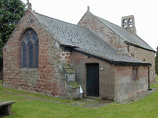
St Jude's Church is on Nantwich Road in Tilstone Fearnall, in the civil parish of Tiverton and Tilstone Fearnall, Cheshire, England. It is an active Anglican parish church in the deanery of Malpas, the archdeaconry of Chester, and the diocese of Chester. Its benefice is combined with that of St Boniface, Bunbury. The church is recorded in the National Heritage List for England as a designated Grade II listed building. It stands opposite the end of the drive leading to Tilstone Lodge.
Clotton Hoofield is a civil parish in Cheshire West and Chester, England. It contains 17 buildings that are recorded in the National Heritage List for England as designated listed buildings, all of which are at Grade II. This grade is the lowest of the three gradings given to listed buildings and is applied to "buildings of national importance and special interest". The parish contains the small settlements of Clotton and Hoofield, but is otherwise rural. The listed buildings are all either domestic or related to farming. They fall into two time-groups; those originating in the 16–17th centuries, and those from the 19th century. All the buildings originating before the later part of the 17th century are timber-framed, or have timber-framed cores; The later buildings are in brick.
Huxley is a former civil parish, now in the parishes of Hargrave and Huxley and Tattenhall and District, in Cheshire West and Chester, England. It contains four buildings that are recorded in the National Heritage List for England as designated listed buildings. Two of these are listed at Grade II*, the middle grade, and the other two are at the lowest grade, Grade II. Apart from the village of Huxley, the parish is entirely rural. The listed buildings consist of a former manor house on a moated site, a bridge across the moat, a farm building, and a canal bridge.
Tilstone Fearnall is a former civil parish, now in the parishes of Tiverton and Tilstone Fearnall and Rushton, in Cheshire West and Chester, England. It contains nine buildings that are recorded in the National Heritage List for England as designated listed buildings, all of which are listed at Grade II. This grade is the lowest of the three gradings given to listed buildings and is applied to "buildings of national importance and special interest". Apart from the village of Tilstone Fearnall, the parish is rural. The Shropshire Union Canal passes through the parish, and three of the listed building are associated with it, a bridge, a lock, and a linkman's hut. The other listed buildings include a church, a vicarage, a former mill, and houses and associated structures.
Tiverton is a former civil parish, now in the parishes of Tiverton and Tilstone Fearnall and Tarporley, in Cheshire West and Chester, England. It contains 20 buildings that are recorded in the National Heritage List for England as designated listed buildings. Of these, one is listed at Grade II*, the middle grade, and the others are at Grade II. The parish is rural, apart from the villages of Tiverton and Hand Green. The Shropshire Union Canal passes through the parish, and there are six listed structures associated with this. Otherwise the listed buildings are houses or farm buildings, some of which date from the 17th century or earlier and are timber-framed, a former Baptist chapel, and a telephone kiosk.

