Tattenhall is a village and former civil parish, now in the parish of Tattenhall and District, 8 miles (13 km) south-east of Chester, in the unitary authority area of Cheshire West and Chester and the ceremonial county of Cheshire, England. In the 2001 census, the population was recorded as 1,986, increasing to 2,079 by the 2011 census.

A civil parish is a country subdivision, forming the lowest unit of local government in England. There are 333 civil parishes in the ceremonial county of Cheshire, most of the county being parished. Cheshire East unitary authority is entirely parished. At the 2001 census, there were 565,259 people living in 332 parishes, accounting for 57.5 per cent of the county's population.

Bickley is a village in the parish of No Man's Heath and District in Cheshire West and Chester and Cheshire, England. According to the 2001 Census it had a population of 498, that reduced to 481 at the 2011 census. The parish included the villages of Bickley Town and Bickley Moss. Bickley was a township in the parish of Malpas. In 1866 Bickley became a civil parish and on 1 April 2015 it was abolished to form "No Mans Heath and District".

Tarvin was, from 1894 to 1974, a rural district in the administrative county of Cheshire, England. The district was named after the village of Tarvin, and saw considerable boundary changes throughout its life.

Picton is a hamlet and former civil parish, now in the parish of Mickle Trafford and District, situated near to Chester, in the borough of Cheshire West and Chester and the ceremonial county of Cheshire, England.
Utkinton is a village and former civil parish, now in the parishes of Utkinton and Cotebrook, in the unitary authority area of Cheshire West and Chester and the ceremonial county of Cheshire, England. It is approximately 2 miles (3.2 km) north of Tarporley, 8 miles (13 km) west of Winsford and 9 miles (14 km) east of Chester. The upper part of Utkinton is known as 'Quarry Bank'. Utkinton is at the heart of the local farming community. The area is also on the Sandstone Trail.
Stanthorne is a village and former civil parish, now in the parish of Stanthorne and Wimboldsley, in the Cheshire West and Chester district, in the ceremonial county of Cheshire, England, 2 miles west of Middlewich. The A54 runs through the village, connecting it to the railway station at Winsford. At the 2011 census, it had a population of 153.

Wimboldsley is a village and former civil parish, now in the parish of Stanthorne and Wimboldsley, in the Cheshire West and Chester district, in the ceremonial county of Cheshire, England, 2 miles south of Middlewich. The population of the parish at the 2011 census was 153.

Brassey Green is a small rural village near Tarporley, in Tiverton and Tilstone Fearnall civil parish, within the unitary authority of Cheshire West and Chester and the ceremonial county of Cheshire, England.

Calveley is a village and former civil parish, now in the parish of Alpraham and Calveley, in the unitary authority area of Cheshire East and the ceremonial county of Cheshire, England. The village lies 5½ miles to the north west of Nantwich. The parish also includes parts of the settlements of Barrets Green and Wardle Bank. The total population is 280 people. The area is largely agricultural and includes a short stretch of the Shropshire Union Canal. There is an Anglican parish church, a primary school and a public house. Nearby villages include Alpraham, Bunbury, Haughton and Wardle. In 2011 the parish had a population of 280.
Mickle Trafford is a village and former civil parish, now in the parish of Mickle Trafford and District, in the unitary authority area of Cheshire West and Chester and the ceremonial county of Cheshire, England. It includes the area known as Plemstall. The A56 road from Chester to Warrington passes through the village and the Chester-Warrington railway line passes immediately to its east.

Lower Kinnerton is a village and former civil parish, now in the parish of Dodleston, in the unitary authority of Cheshire West and Chester and the ceremonial county of Cheshire, England, close to the England–Wales border. The neighbouring village of Higher Kinnerton is across the border in Flintshire. Lower Kinnerton is south of Broughton and to the north west of the village of Dodleston. It is a small agricultural community, which is also home to a local kennel and cattery business.

Hapsford is a village and former civil parish, now in the parish of Dunham-on-the-Hill and Hapsford, in the unitary authority area of Cheshire West and Chester and the ceremonial county of Cheshire, England. It is located on the A5117 road, with Helsby to the east and the village of Elton, near Ellesmere Port, to the north west. Junction 14 of the M56 motorway and Chester services motorway service station are sited nearby.

Wimbolds Trafford is a hamlet and former civil parish, now in the parish of Mickle Trafford and District, in the unitary authority area of Cheshire West and Chester and the ceremonial county of Cheshire, England. The hamlet lies on the B5132 road, approximately 5 miles (8 km) to the north east of Chester and north of the village of Mickle Trafford.

Huxley is a small rural village and former civil parish, now in the parish of Hargrave and Huxley, in the Cheshire West and Chester district, and ceremonial county of Cheshire in England. In 2001 the parish had a population of 220, increasing to 251 at the 2011 Census. The civil parish was abolished in 2015
Poulton is a settlement and former civil parish, now in the parish of Poulton and Pulford, in the Cheshire West and Chester, in the ceremonial county of Cheshire, England. In 2001 census the parish had a recorded population of 92.

Tiverton is a village and former civil parish, now in the parish of Tiverton and Tilstone Fearnall, in the Cheshire West and Chester district and ceremonial county of Cheshire in England. It had a population of 406 in 2001, reducing to 318 at the 2011 census. Tiverton became a civil parish in 1866, on 1 April 2015 the parish was abolished to form Tiverton and Tilstone Fearnall; part also went to Tarporley. The former civil parish of Tiverton and the current parish of Tiverton and Tilstone Fearnall both include the hamlet of Four Lane Ends.

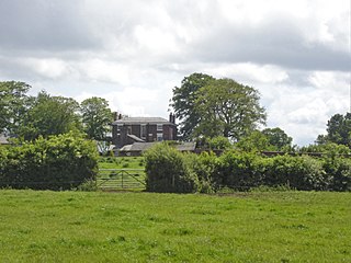
Tilstone Lodge is a country house in the parish of Tiverton and Tilstone Fearnall, Cheshire, England. It was built between 1821 and 1825 for Admiral John Richard Delap Halliday, who later changed his surname to Tollemache. The architect was Thomas Harrison of Chester. The house is described by Figueirdo and Treuherz as being "pleasantly spacious but not grand". It is constructed in stuccoed brick with ashlar dressings, and it has a slate roof. The house is in two storeys with sash windows, and has a porte-cochère with two pairs of unfluted Doric columns. An orangery was added to the southeast corner later in the 19th century. The house is recorded in the National Heritage List for England as a designated Grade II listed building.

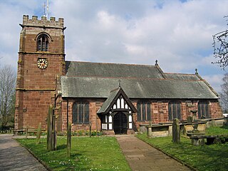
St Jude's Church is on Nantwich Road in Tilstone Fearnall, in the civil parish of Tiverton and Tilstone Fearnall, Cheshire, England. It is an active Anglican parish church in the deanery of Malpas, the archdeaconry of Chester, and the diocese of Chester. Its benefice is combined with that of St Boniface, Bunbury. The church is recorded in the National Heritage List for England as a designated Grade II listed building. It stands opposite the end of the drive leading to Tilstone Lodge.
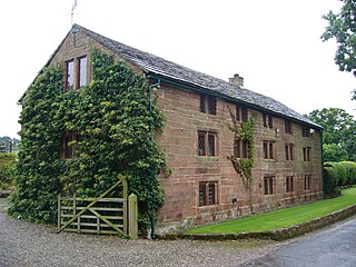
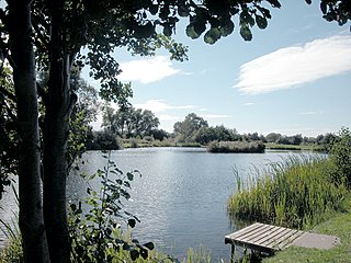
Tilstone Fearnall is a former civil parish, now in the parishes of Tiverton and Tilstone Fearnall and Rushton, in Cheshire West and Chester, England. It contains nine buildings that are recorded in the National Heritage List for England as designated listed buildings, all of which are listed at Grade II. This grade is the lowest of the three gradings given to listed buildings and is applied to "buildings of national importance and special interest". Apart from the village of Tilstone Fearnall, the parish is rural. The Shropshire Union Canal passes through the parish, and three of the listed building are associated with it, a bridge, a lock, and a linkman's hut. The other listed buildings include a church, a vicarage, a former mill, and houses and associated structures.

