
A civil parish is a country subdivision, forming the lowest unit of local government in England. There are 333 civil parishes in the ceremonial county of Cheshire, most of the county being parished. Cheshire East unitary authority is entirely parished. At the 2001 census, there were 565,259 people living in 332 parishes, accounting for 57.5 per cent of the county's population.
Chester Castle is an area around the castle in Chester. It was historically an extra-parochial area and today remains a civil parish, albeit with no inhabitants.

Alpraham is a village and former civil parish, now in the parish of Alpraham and Calveley, in the Cheshire East district, in the ceremonial county of Cheshire, England. It is on the A51 road between Nantwich and Chester, seven miles north-west of Nantwich. The population is around 400.

Ashton Hayes is a village and former civil parish, now in the parish of Ashton Hayes and Horton-cum-Peel, in the unitary authority of Cheshire West and Chester and ceremonial county of Cheshire, England. It is located about 8 miles east of Chester on the B5393 road. The nearest villages are Mouldsworth to the north east and Kelsall to the south east. According to the 2011 Census it had a population of 936. The main village in the parish – formerly known as Ashton – was renamed Ashton Hayes following a referendum, to avoid confusion with other places of the same name.

Bickley is a village in the parish of No Man's Heath and District in Cheshire West and Chester and Cheshire, England. According to the 2001 Census it had a population of 498, that reduced to 481 at the 2011 census. The parish included the villages of Bickley Town and Bickley Moss. Bickley was a township in the parish of Malpas. In 1866 Bickley became a civil parish and on 1 April 2015 it was abolished to form "No Mans Heath and District".
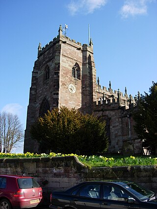
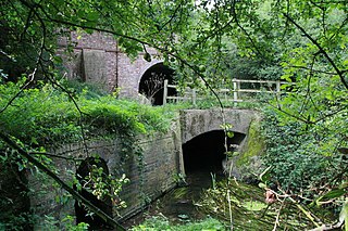
Malpas is a market town and a civil parish in the unitary authority of Cheshire West and Chester and the ceremonial county of Cheshire, England. It lies near the borders with Shropshire and Wales, and had a population of 1,673 at the 2011 census.

Eaton is a small village and former civil parish, now in the parish of Rushton, in the Cheshire West and Chester district, in the ceremonial county of Cheshire, England, about two miles from the town of Tarporley. In 1931 the parish had a population of 353.

Hooton is a suburban village and former civil parish on the Wirral Peninsula, within the unitary authority of Cheshire West and Chester and the ceremonial county of Cheshire, England. It was once a separate village but was incorporated into Ellesmere Port as the town expanded outwards during the twentieth century.
Puddington is a village and civil parish on the Wirral Peninsula, in the unitary authority of Cheshire West and Chester and the ceremonial county of Cheshire, England. It is located to the south east of the town of Neston and close to the border with Wales.

Calveley is a village and former civil parish, now in the parish of Alpraham and Calveley, in the unitary authority area of Cheshire East and the ceremonial county of Cheshire, England. The village lies 5½ miles to the north west of Nantwich. The parish also includes parts of the settlements of Barrets Green and Wardle Bank. The total population is 280 people. The area is largely agricultural and includes a short stretch of the Shropshire Union Canal. There is an Anglican parish church, a primary school and a public house. Nearby villages include Alpraham, Bunbury, Haughton and Wardle. In 2011 the parish had a population of 280.

Ridley is a former civil parish, now in the parish of Bulkeley and Ridley, in the unitary authority area of Cheshire East and the ceremonial county of Cheshire, England, which lies to the north east of Malpas and to the west of Nantwich. The parish is largely rural with scattered farms and buildings and no significant settlements. In 2001, the population was 120. Nearby villages include Bulkeley, Bunbury, Faddiley, Peckforton and Spurstow. At the 2011 Census the population had fallen less than 100. Details are included in the civil parish of Peckforton.
Foulk Stapleford is a former civil parish, now in the parish of Hargrave and Huxley, in the unitary authority of Cheshire West and Chester and the ceremonial county of Cheshire, England. The population of the civil parish as taken at the 2011 census was 161. The civil parish was abolished in 2015 to form Hargrave and Huxley.

Lower Kinnerton is a village and former civil parish, now in the parish of Dodleston, in the unitary authority of Cheshire West and Chester and the ceremonial county of Cheshire, England, close to the England–Wales border. The neighbouring village of Higher Kinnerton is across the border in Flintshire. Lower Kinnerton is south of Broughton and to the north west of the village of Dodleston. It is a small agricultural community, which is also home to a local kennel and cattery business.

Hapsford is a village and former civil parish, now in the parish of Dunham-on-the-Hill and Hapsford, in the unitary authority area of Cheshire West and Chester and the ceremonial county of Cheshire, England. It is located on the A5117 road, with Helsby to the east and the village of Elton, near Ellesmere Port, to the north west. Junction 14 of the M56 motorway and Chester services motorway service station are sited nearby.
Churton by Aldford is a former civil parish, now in the parish of Churton, in the borough of Cheshire West and Chester and ceremonial county of Cheshire in England. In 2001 it had a population of 136. The parish included the northern part of the village of Churton. It is associated with the nearby Church of England parish of St John the Baptist, Aldford, the nearest place of public worship.

Churton by Farndon is a former civil parish, now in the parish of Churton, in the borough of Cheshire West and Chester and ceremonial county of Cheshire in England. In 2001 it had a population of 146, increasing to 153 at the 2011 Census. The parish included the southern part of the village of Churton.

Claverton is a former civil parish, now in the parish of Eaton and Eccleston, in the borough of Cheshire West and Chester and ceremonial county of Cheshire in England. In 2001 it had a population of 7. The parish included the site of The King's School. The civil parish was abolished in 2015 to form Eaton and Eccleston.

Edgerley is a former civil parish, now in the parish of Churton, in the borough of Cheshire West and Chester and ceremonial county of Cheshire in England. In 2001 it had a population of 7.

Hatton is a former civil parish, now in the parishes of Hargrave and Huxley, Golborne David and Tattenhall and District, in the unitary authority of Cheshire West and Chester and ceremonial county of Cheshire, England. The parish included most of the village of Hatton Heath, which is approximately 6 miles (9.7 km) south east of Chester and 4 miles (6.4 km) north-west of Tattenhall. The civil parish was abolished in 2015 and became part of Hargrave and Huxley, Golborne David and Tattenhall and District.
Newton is a settlement and as Newton-by-Tattenhall a former civil parish, now in the parish of Tattenhall and District in the Cheshire West and Chester district, and ceremonial county of Cheshire in England. In 2011 it had a population of 131, up from 116 in 2001. The civil parish was abolished in 2015 to form Tattenhall and District, part also went to Hargrave and Huxley.

