
Chester was a non-metropolitan local government district of Cheshire, England from 1974 to 2009. It had the status of a city and a borough, and the local authority was called Chester City Council.

A civil parish is a country subdivision, forming the lowest unit of local government in England. There are 333 civil parishes in the ceremonial county of Cheshire, most of the county being parished. Cheshire East unitary authority is entirely parished. At the 2001 census, there were 565,259 people living in 332 parishes, accounting for 57.5 per cent of the county's population.

No Man's Heath is a village in the unitary authority of Cheshire West and Chester and the ceremonial county of Cheshire, England. Its name has historically also been spelt Nomansheath and Noman's Heath, the latter being the version formerly favoured by the General Post Office.

Tushingham cum Grindley is a former civil parish, now in the parish of Tushingham-cum-Grindley, Macefen and Bradley, in the unitary authority of Cheshire West and Chester and the ceremonial county of Cheshire, England. The parish contained the village of Tushingham and the hamlet of Bell o' th' Hill. According to the 2001 UK census, the total population of the civil parish was 166, rising to 187 at the 2011 Census. The civil parish was abolished in 2015 to form Tushingham-cum-Grindley, Macefen and Bradley.

Tarvin was, from 1894 to 1974, a rural district in the administrative county of Cheshire, England. The district was named after the village of Tarvin, and saw considerable boundary changes throughout its life.
Malpas was, from 1894 to 1936, a rural district in the administrative county of Cheshire, England. The district was named after the village of Malpas.
St Chad's Chapel is an isolated church in the scattered community of Tushingham in the civil parish of Tushingham-cum-Grindley, Macefen and Bradley, Cheshire, England. The only approach to the chapel is on footpaths across fields from the A41 road. It is recorded in the National Heritage List for England as a designated Grade I listed building.
Tushingham is a scattered community in the civil parish of Tushingham-cum-Grindley, Macefen and Bradley, in the Cheshire West and Chester district, in the county of Cheshire, England.

Macefen is a former civil parish in the unitary authority of Cheshire West and Chester and the ceremonial county of Cheshire, England. Its area is now part of the civil parishes of Tushingham-cum-Grindley, Macefen and Bradley and No Man's Heath and District. Macefen lies 2 miles (3.2 km) east of the village of Malpas and 5 miles (8.0 km) north west of Whitchurch, Salop. Part of the village of No Man's Heath was within the northern boundary of Macefen. Its name is thought to possibly be an anglicisation of an older Welsh placename Maes-y-ffin, "the open field (maes) at the boundary (ffin)".
Bradley Green is a hamlet in Cheshire West and Chester, England. It lies about 1+1⁄2 miles (2.4 km) southeast of the town of Malpas and falls within the civil parish of Tushingham-cum-Grindley, Macefen and Bradley.

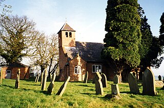
St Chad's Church is on Chester Road in the civil parish of Tushingham-cum-Grindley, Macefen and Bradley, Cheshire, England. It is an active Anglican parish church in the deanery of Malpas, the archdeaconry of Chester, and the diocese of Chester. Its benefice is combined with those of St Michael, Marbury, and St Mary, Whitewell. The church is recorded in the National Heritage List for England as a designated Grade II listed building.
Bradley is a former civil parish, now in the parishes of Tushingham-cum-Grindley, Macefen and Bradley and Malpas in Cheshire West and Chester, England. It contains five buildings that are recorded in the National Heritage List for England as designated listed buildings, all of which are at Grade II. This grade is the lowest of the three gradings given to listed buildings and is applied to "buildings of national importance and special interest". The parish is entirely rural, and the listed buildings consist of two farmhouses and a farm building, and two guideposts from the 19th century.
Edge is a former civil parish, now in the parishes of No Man's Heath and District and Malpas, in Cheshire West and Chester, England. It contains 18 buildings that are recorded in the National Heritage List for England as designated listed buildings. One of these is listed at Grade II*, the middle grade, and the rest at the lowest grade, Grade II. The parish is entirely rural, and most of the listed buildings are domestic, or related to farming. The most important building is the country house, Edge Hall, which dates from about 1600. Many of the other listed buildings are houses and cottages, either timber-framed or with a timber-framed core, dating from the 17th century. Other structures in the list include a former corn mill, former stables, and a bridge near Edge Hall.
Hampton is a former civil parish, now in the parishes of No Man's Heath and District and Malpas, in Cheshire West and Chester, England. It contains four buildings that are recorded in the National Heritage List for England as designated listed buildings. One of these is listed at Grade II*, the middle grade, and the other three at the lowest grade, Grade II. The parish is entirely rural, and all the listed buildings are domestic, or related to farming.
The county of Cheshire, England, has many buildings that have been listed.
Tushingham cum Grindley is a former civil parish, now in the parish of Tushingham-cum-Grindley, Macefen and Bradley, in Cheshire West and Chester, England. It contains 15 buildings that are recorded in the National Heritage List for England as designated listed buildings. Of these, one is listed at Grade I, the highest of the three grades, and the others are at Grade II, the lowest grade. The parish is entirely rural, and the listed buildings are mainly houses, churches, farms, and associated structures. The Llangollen Canal runs through the parish, and two structures associated with the canal are also listed.
Marbury cum Quoisley is a civil parish in Cheshire East, England. It contains 11 buildings that are recorded in the National Heritage List for England as designated listed buildings. Of these, one is listed at Grade II*, the middle grade, and the others are at Grade II. Apart from the village of Marbury the parish is rural. The major buildings in the parish are St Michael's Church and Marbury Hall; these and some associated buildings are listed. Also listed are some 16th and 17th-century houses and farm buildings that are timber-framed or incorporate timber framing. The parish includes the part of the Combermere estate that contains a monumental obelisk that is listed.

Bell o' th' Hill is a small, scattered settlement in the unitary authority of Cheshire West and Chester and the ceremonial county of Cheshire, England, close to the border with Shropshire. Until 2015 it was in the civil parish of Tushingham cum Grindley: it is now in the civil parish of Tushingham-cum-Grindley, Macefen and Bradley. The settlement is adjacent to the A41 road north of Whitchurch, and an earlier line of the main road passes through it.
Tushingham-cum-Grindley, Macefen and Bradley is a civil parish in the unitary authority of Cheshire West and Chester and the ceremonial county of Cheshire, England. It was created in 2015, under the terms of the Local Government and Public Involvement in Health Act 2007, from the civil parish of Tushingham cum Grindley with parts of the historic civil parishes of Macefen and Bradley.

