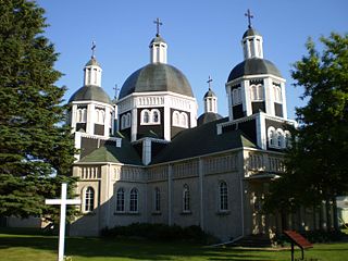
Dauphin is a city in Manitoba, Canada, with a population of 8,368 as of the 2021 Canadian Census, with an additional 2,136 living in the surrounding Rural Municipality of Dauphin (RM), for a total of 10,504 in the RM and city combined. The city takes its name from Lake Dauphin and Fort Dauphin, which were named by explorer Pierre Gaultier de La Vérendrye in honour of the Dauphin of France, the heir to the French throne. Dauphin is Manitoba's ninth largest community and serves as a hub to the province's Parkland Region. The current mayor of Dauphin is David Bosiak. Conservative Dan Mazier has been the member of Parliament for the Dauphin—Swan River—Neepawa riding since October 2019. Progressive Conservative Brad Michaleski is the current member of the Legislative Assembly of Manitoba.
Roblin is an unincorporated urban community in the Municipality of Roblin, Manitoba, Canada. It is located approximately 400 km (250 mi) northwest of Winnipeg.

Turtle Mountain is a provincial electoral district in the Canadian province of Manitoba. It was created with the westward expansion of the province's boundaries in 1881, eliminated by redistribution in 1968, and re-established in 1979, formally returned to the electoral map with the provincial election of 1981, was dissolved for the 2011 election and returned once again for the 2019 Manitoba general election.

The Pembina Valley is an informal geographic region of the Canadian province of Manitoba. It is named for its major geographical feature, the Pembina Valley, which runs through the southwestern part of the region.

The Rural Municipality of Hanover is a rural municipality (RM) in southeastern Manitoba, Canada, located southeast of Winnipeg in Division No. 2.
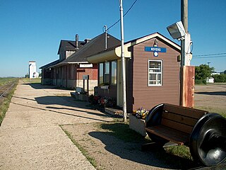
Rivers is an unincorporated urban community in the Riverdale Municipality within the Canadian province of Manitoba. It is located 40 kilometres (25 mi) northwest of Brandon, 473 metres (1,552 ft) above sea level. It is within the Westman Region. Agriculture, health and related businesses provide income for the community and area. Rivers has a population of 1,257 people in the 2016 census.

Parkland is an informal geographic region of the Canadian province of Manitoba, located between Lakes Manitoba and Winnipegosis on the east and the Manitoba–Saskatchewan border on the west.

The Central Plains Region is an informal geographic region of the Canadian province of Manitoba located in the south central part of the Canadian province of Manitoba, directly west of Winnipeg.

Eastern Manitoba, or the Eastman Region, is an informal geographic region of the Canadian province of Manitoba. It is bounded on the north by the Winnipeg River and Lake Winnipeg, on the east by the Manitoba-Ontario border, on the south by the Canada–US border, and on the west by the Red River. With a population of 128,855 as of the 2021 Canadian census, the Eastman Region is the second most populous region outside of the Winnipeg Metropolitan Region.

Benito is an unincorporated urban community in the Municipality of Swan Valley West, Manitoba, Canada.

Oak Lake is an unincorporated urban community in the Rural Municipality of Sifton within the Canadian province of Manitoba that held town status prior to January 1, 2015. It is located 52 km (32 mi) west of Brandon along the Trans-Canada Highway. The lake after which it was named is in the rural municipality's western area.

Division No. 5 is a census division located within the Westman Region in the south west area of the province of Manitoba, Canada. Unlike in some other provinces, census divisions do not reflect the organization of local government in Manitoba. These areas exist solely for the purposes of statistical analysis and presentation; they have no government of their own.
Division No. 6 (Virden) is a census division located within the Westman Region of south west Manitoba, located in the unceded territory of the Dakota people in Treaty 2. Unlike in some other provinces, census divisions do not reflect the organization of local government in Manitoba. These areas exist solely for the purposes of statistical analysis and presentation; they have no government of their own.
Census Division No. 15 is a census division located within the Westman Region of the province of Manitoba, Canada. Unlike in some other provinces, census divisions do not reflect the organization of local government in Manitoba. These areas exist solely for the purposes of statistical analysis and presentation; they have no government of their own.
Provincial Trunk Highway 18 is a provincial highway in the Canadian province of Manitoba. It is a north-south route; the southern terminus is the St. John–Lena Border Crossing at the Canada–United States border and the northern terminus is at PTH 2, 7.1 kilometres southeast of Wawanesa. The highway passes through the communities of Killarney and Ninette. It is designated as an RTAC route, meaning it is capable of handling RTAC vehicles such as a truck, a truck and pony trailer, a truck and full trailer, a truck tractor and semi-trailer, an A-train, a B-train, or a C-train.
The Municipality of Shoal Lake is a former rural municipality (RM) in the Canadian province of Manitoba. It was originally incorporated as a rural municipality on January 1, 2011. It ceased on January 1, 2015, as a result of its provincially mandated amalgamation with the RM of Strathclair to form the Rural Municipality of Yellowhead.
Spruce Woods is a provincial electoral division in the Canadian province of Manitoba. It was created by redistribution in 2008 out of parts of Minnedosa and Turtle Mountain and notably gained parts of the City of Brandon and Arthur-Virden in the 2018 redistribution.
