
Westmount is an affluent suburb on the Island of Montreal, in southwestern Quebec, Canada. It is an enclave of the city of Montreal, with a population of 19,658 as of the Canada 2021 Census.

The North End of Halifax is a subdivision of Halifax, Nova Scotia occupying the northern part of Halifax Peninsula immediately north of Downtown Halifax. The area once included historic Africville, and parts of it were severely damaged in the Halifax Explosion during World War I. A neighbourhood with strong African Nova Scotian roots, the area has undergone gentrification in recent years.

The Spring Garden Road area, along with Barrington Street is a major commercial and cultural district in Halifax, Nova Scotia, Canada. It acquired its name from the fresh water spring that flows directly beneath it. It comprises Spring Garden Road, South Park Street, and a number of smaller side streets. The area is considered to be one of the trendiest areas in Halifax and is the busiest shopping district east of Quebec.
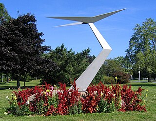
Saunders Park is an urban park in Halifax, Nova Scotia, Canada. It is located in West End, Halifax on Chebucto Road at the site of the now defunct Halifax Civic Airport, the city's first aerodrome built on the former Bluebell Farm in 1931. The airfield had two grass airstrips, initially at 1800 x 600 feet and 2000 x 600 feet and extended by 200 and 250 respectively in 1938. It operated until 1941 when the land was converted to an army base and civil airport operations were moved to Dartmouth Airport and then to Halifax International Airport in 1960. The hangars and terminal building were located near the present day park along Connaught Avenue. The park serves the neighbourhood of Westmount.
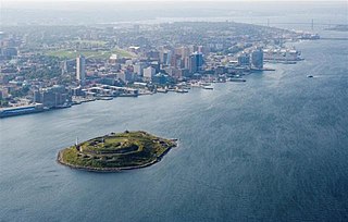
Georges Island is a glacial drumlin and the largest island entirely within the harbour limits of Halifax Harbour located in Nova Scotia's Halifax Regional Municipality. The Island is the location of Fort Charlotte - named after King George's wife Charlotte. Fort Charlotte was built during Father Le Loutre's War, a year after Citadel Hill. The island is now a National Historic Site of Canada. As of August 6, 2020, the island is open to public tours through Thanksgiving weekend.

Deadman's Island is a small peninsula containing a cemetery and park located in the Northwest Arm of Halifax Harbour in Nova Scotia, Canada. The area was first used as a training grounds for the British military, and later became a burial ground for dead prisoners of war from nearby Melville Island. In the early 1900s the site became an amusement park before being annexed to the city of Halifax in the 1960s. Though development projects were considered for the site, these plans met with popular protest, and instead Deadman's Island became a heritage park, Deadman's Island Park.
Goff's is a Canadian rural community in Nova Scotia's Halifax Regional Municipality.
Porters Lake is a rural community in the Eastern Shore region of the Halifax, Nova Scotia, Canada, between Trunk 7 and Route 207, 27.8 km from Halifax. The residents mainly commute to jobs in Dartmouth, Burnside Industrial Park or in Downtown Halifax. The community is built around the lake from which it takes its name.
The Halifax Regional Municipality (HRM) in the Canadian province of Nova Scotia is composed of more than 200 communities and neighbourhoods. As of the 2016 Census, the municipality has a landmass of 549,035 hectares and is home to 403,131 people.
Beechville is a Black Nova Scotian settlement and suburban community within the Halifax Regional Municipality of Nova Scotia, Canada, on the St. Margaret's Bay Road. The Beechville Lakeside Timberlea (BLT) trail starts here near Lovett Lake, following the line of the old Halifax and Southwestern Railway. Ridgecliff Middle School, located in Beechville Estates, serves the communities of Beechville, Lakeside and Timberlea.

Westmount is an older inner city neighbourhood located near the centre of Saskatoon, Saskatchewan, Canada. It mostly consists of low-density, single detached dwellings. As of 2009, the area is home to 2,232 residents. The neighbourhood is considered a lower-income area, with an average family income of $44,729, an average dwelling value of $162,491 and a home ownership rate of 68.9%. According to MLS data, the average sale price of a home as of 2013 was $207,347.

Woodcroft is a neighbourhood located in northwest Edmonton, Alberta, Canada. Surrounded by a mixture of residential neighbourhoods and light industrial subdivisions, it is bounded by 118 Avenue to the north, Groat Road to the east, 111 Avenue to the south, and 142 Street to the west. The neighbourhoods is home to Coronation Park and the Telus World of Science.

The West End is a neighbourhood of Halifax Regional Municipality in the Canadian province of Nova Scotia, located on the western half of the Halifax Peninsula. The West End is predominantly middle class with many blocks of tree-lined older residential streets. However, it is also home to many students and small low rent units. Rising real estate prices have also led to some levels of gentrification.
Westmount is a neighbourhood in the southwest part of London, Ontario, Canada. As of the 2016 Canadian census, the population of Westmount is 18,985 (2016). The top five ethnic origins are English, Scottish, Canadian, Irish, and German. The average income for the neighbourhood is $79,833, one of the highest in the city, however employment levels are down in comparison with the city. The top three occupations of Westmount residents are: Sales and Service occupations, Business & Finance, and Administration.
Westmount is an established central-west residential neighbourhood in Edmonton, Alberta, Canada. It is geographically close to the downtown core.
Russell Lake West is a planned residential subdivision and commercial development in the eastern part of the community of Dartmouth in the Halifax Regional Municipality, Nova Scotia. The area began construction in 2006 with the creation of Exit 8 on Highway 111, providing access from the southwest to the area via Mount Hope Avenue, which as of October 2011, Exit 8 also provides direct access into the Woodside Industrial Park. Russell Lake West is located next to the community of Woodside and a park and walking trails provide direct access to and from Woodside. The subdivision covers 251 ha, and houses approximately 3,200 people. and houses approximately 3,200 people.

Radburn design housing is a concept for planned housing estates, based on a design that was originally used in Radburn, New Jersey, United States.
Bridgeview is a Residential subdivision, developed by B.D Stevens in the 1960s. Located in the community of Rockingham on Mainland Halifax, just off the Bedford Highway, it is considered to be part of the Halifax Regional Municipality Nova Scotia and is found on the shore of the Bedford Basin in Halifax Harbour.
Green Acres, Nova Scotia is a residential neighbourhood in Halifax on the Mainland Halifax within the Halifax Regional Municipality Nova Scotia. Not to be confused with Green Acres the Subdivision (land) in Kings County, Nova Scotia in The Annapolis Valley.
Leiblin Park, Nova Scotia is a residential neighbourhood in Halifax on the Mainland Halifax within the Halifax Regional Municipality, Nova Scotia.
