Halifax Peninsula

Last updated
Halifax Peninsula
Old Halifax
Montage of the Halifax Peninsula.jpg
From top right, pictures are Town Clock, Hydrostone Shops, HUGA Trail, Saunders Park, and the Halifax Central Library.
Novascotiahrm-halifaxpeninsula.png
Location of Halifax Peninsula in municipal Halifax.
Canada Nova Scotia location map 2.svg
Red pog.svg
Halifax Peninsula
Location of Halifax Peninsula in Nova Scotia
Coordinates: 44°38′52.0″N63°34′27.4″W / 44.647778°N 63.574278°W / 44.647778; -63.574278
CountryFlag of Canada (Pantone).svg  Canada
ProvinceFlag of Nova Scotia.svg  Nova Scotia
Municipality Halifax
Community Halifax
Municipal Districts District 7 (Halifax South Downtown), District 8 (Halifax Peninsula North), District 9 (Halifax West Armdale)
Founded1749
Neighborhoods Downtown, Hydrostone, North End, Quinpool, South End, Spring Garden, West End
Government
  TypeMunicipal Council
Area
[1]
  Total18.949 km2 (7.316 sq mi)
Population
 (2021) [2]
  Total72,169
  Density3,808/km2 (9,860/sq mi)
  Change 2016-2021
Increase2.svg14.1
Time zone UTC−4 (AST)
  Summer (DST) UTC−3 (ADT)
Postal code span
B3H, B3J, B3K, B3L
Area code(s) 782, 902
Part of a series about Places in Nova Scotia

The Halifax Peninsula is a peninsula within the urban area of the Municipality of Halifax, Nova Scotia.

Contents

History

The town of Halifax was founded by the British government under the direction of the Board of Trade and Plantations under the command of Governor Edward Cornwallis in 1749. [3] The founding of the town sparked Father Le Loutre's War. The original settlement was clustered in the southeastern part of the peninsula along The Narrows, between a series of forts (Fort Needham to the north, Fort George (Citadel Hill) in the middle, and Fort Massey to the south) and the harbour. With time, the settlement expanded beyond its walls and gradually encroached over the entire peninsula, creating residential neighbourhoods defined by the peninsula's geography.

From 1749 until 1841, Halifax was a town. After a protracted struggle between residents and the Executive Council, the town was incorporated into a city in 1841. From 1841 until 1969, the entire Peninsula was home to the former City of Halifax.

In 1789, the University of King's College was founded. Roughly thirteen years later, Saint Mary's University was founded in 1802. Subsequently, Dalhousie University was founded 1818. NSCAD University was founded in 1867.

In 1867, the Halifax Public Gardens and Victoria Park, Halifax were created, with many Victorian Era monuments. Builders such as George Lang created many landmark buildings.

During 1916–1919 a mega construction project was undertaken by Canadian Government Railways (later Canadian National Railway) along the peninsula's Northwest Arm shoreline which saw a 4 km (2.5 mi) long rock cut blasted up to 30 m (98 ft) deep for a railway line running from Fairview Cove to serve the new Halifax Ocean Terminals which were built at the southeastern end; the rock from blasting work in the cut being used as infill for a portion of The Narrows.

Rudyard Kipling paid homage to Halifax in his poem The Song of Cities:

Into the mist my guardian prows put forth,
Behind the mist my virgin ramparts lie,
The Warden of the Honour of the North,
Sleepless and veiled am I!

In 1969, adjacent rural areas within the former County of Halifax (that at this time were beginning to urbanize) west of the isthmus were annexed into the city. The city annexed Armdale, Clayton Park, Fairview, Rockingham and Spryfield.

On 1 April 1996, Halifax County was dissolved and all of its places (cities, suburbs, towns, and villages) were turned into communities of a single-tier municipality named Halifax Regional Municipality. Subsequently, the Halifax Peninsula was included in the new community of Halifax, within the new Municipality of Halifax.

Today, the Peninsula is the bustling region of the community of Halifax.

Geography

Halifax Harbour from the air looking South including the Halifax Peninsula at upper right Halifax from the air.jpg
Halifax Harbour from the air looking South including the Halifax Peninsula at upper right

Provincial electoral districts

Colloquial neighbourhoods

Historic neighbourhoods

Stratigraphy

The bedrock of this peninsula is Precambrian slate. Glaciers during the Pleistocene era converted the rock surface to an olive-colored loamy till. Glaciation also removed reddish till from sedimentary rock to the north and redeposited it as a drumlin to form Citadel Hill. The stony loam to sandy loam soils are mapped as Bridgewater series on olive till and Wolfville series on the Citadel Hill drumlin. [4]

Topography

According to the 2021 Census, the Halifax Peninsula covers approximately 1,894.9 hectares (18.949 km2). [5]

Peninsular Halifax extends from the western shore of Halifax Harbour, and is connected to the much larger Chebucto Peninsula by an isthmus measuring 2.6 km (1.6 mi), defined by Fairview Cove and the Bedford Basin to the north and the Northwest Arm to the southwest. Down the length of this isthmus is Joseph Howe Drive, generally considered to be the boundary between mainland Halifax and peninsular Halifax. The Halifax Peninsula creates The Narrows, a constriction of Halifax Harbour to its east.

The peninsula measures approximately 3.3 km (2.1 mi) at its widest and approximately 7.5 km (4.7 mi) at its longest, the peninsula's topography is relatively flat near the isthmus where Chebucto Field, an aerodrome that preceded Halifax Stanfield International Airport was located. The northern part of the peninsula rises to approximately 60 m (200 ft) above sea level as a glacial drumlin at Fort Needham, with the central area of the peninsula being a plateau roughly 40–50 m (130–160 ft). in elevation. Another drumlin approximately 60 m (200 ft) above sea level is located at Citadel Hill and immediately offshore to the east at Georges Island.

Parks and Recreation

Art Gallery of Nova Scotia (former Halifax Federal Building) by George Lang (builder) Art Gallery of Nova Scotia.JPG
Art Gallery of Nova Scotia (former Halifax Federal Building) by George Lang (builder)
Oxford Theatre, on Quinpool Road in the peninsula's West End Oxford Theatre.JPG
Oxford Theatre, on Quinpool Road in the peninsula's West End

Arenas

Art Galleries

Community Centres

Libraries

Museums

Parks

Pools

Trails

Demographics

The Peninsula's population grew to a high of 92,511 in 1961--and decreased thereafter. However, in recent years, the population has increased. In 2016, the population was 63,210 people. By 2021, the population increased to 72,169 people--an increase of 14.1% from 2016.

Census TractLand area (km2)Population (2021) [6] Population (2016) [7] Population Density (people per km2) (2021)Population Change (%)
2050003.002.3652,8852,9551,219Decrease2.svg2.4
2050004.010.4814,0453,4668,402Increase2.svg16.7
2050004.020.4825,4664,77111,340Increase2.svg14.6
2050005.000.7691,8131,8082,358Increase2.svg0.3
2050006.001.0543,5533,1293,371Increase2.svg13.6
2050007.001.161,9471,8591,677Increase2.svg4.7
2050008.000.5045,2032,77810,325Increase2.svg87.3
2050009.000.6352,8752,3574,528Increase2.svg22
2050010.000.8346,0195,0367,213Increase2.svg19.5
2050011.000.8086,0135,6317,446Increase2.svg6.8
2050012.000.5182,9012,4825,598Increase2.svg16.9
2050013.000.8052,6302,5613,267Increase2.svg2.7
2050018.001.3973,7583,5442,690Increase2.svg6
2050019.000.8915,1265,0625,755Increase2.svg1.3
2050020.000.9993,6022,5623,607Increase2.svg40.6
2050021.000.8773,5443,3144,041Increase2.svg6.9
2050022.002.8335,5815,3011,969Increase2.svg5.3
2050023.001.5375,2084,5943,388Increase2.svg13.4
Peninsula18.94972,16963,2103,808Increase2.svg14.1

Economy

Being a very populated area, the peninsula hosts many businesses, government services, hospitals, post-secondary institutions, and more.

Transportation

Rail

The Halifax Station is operated by Via Rail, and is the easternmost station for the Ocean. The Ocean travels from Halifax to Montreal once per week.

Road

There are many kilometres of avenues, lanes, roads, and streets that criss-cross throughout the Peninsula. The main thoroughfare is Robie Street. Robie Street runs approximately 4 km (2.5 mi), then continues on as Massachusetts Avenue.

Public Transit

Source: [8]

Halifax Transit provides many transit routes that traverse the peninsula. There are two terminals located within the area; the Scotia Square Terminal in the South End; and the Mumford Terminal in the West End.

Bus

Wheelchair symbol.svg Wheelchair – Uses Accessible Low Floor (ALF) buses only.
Clock simple.svg Rush Hour Service Only
BSicon BICYCLE.svg Designated Bike Route
MetroLink-Halifax.svg MetroLink Service
MetroExpress-Halifax.svg MetroX Service

Route numberRoute nameFeaturesInner terminalOuter terminalNotes
1Spring Garden Wheelchair symbol.svg BSicon BICYCLE.svg MumfordBridge
2Fairview Wheelchair symbol.svg BSicon BICYCLE.svg Water StreetLacewood
3Crosstown Wheelchair symbol.svg BSicon BICYCLE.svg MumfordBridge; Highfield; Lacewood
4Universities Dalhousie University, Saint Mary's University Lacewood
5Portland Wheelchair symbol.svg BSicon BICYCLE.svg Scotia SquareBridge; Penhorn; Portland Hills
7 (7ᴀ/7ʙ)Peninsula Wheelchair symbol.svg BSicon BICYCLE.svg Scotia Square7ᴀ runs in a clockwise direction, and runs in a counter-clockwise direction.
8Sackville Wheelchair symbol.svg BSicon BICYCLE.svg Scotia SquareBayers Road Centre; Cobequid; Sackville
9 (9ᴀ/9ʙ)Greystone (9ᴀ); Herring Cove (9ʙ)Scotia SquareMumford
10Dalhousie Wheelchair symbol.svg BSicon BICYCLE.svg Scotia SquareBridge; M District
21Timberlea Wheelchair symbol.svg BSicon BICYCLE.svg Lacewood
22Armdale Wheelchair symbol.svg BSicon BICYCLE.svg Mumford
24Leiblin Park Wheelchair symbol.svg BSicon BICYCLE.svg Mumford
25Governors Brook Wheelchair symbol.svg BSicon BICYCLE.svg Mumford
26Springvale Wheelchair symbol.svg BSicon BICYCLE.svg Mumford
28Bayers Lake Wheelchair symbol.svg BSicon BICYCLE.svg MumfordBayers Road; Lacewood
29Barrington Wheelchair symbol.svg BSicon BICYCLE.svg Scotia Square; Water StreetBayers Road; Mumford
50Dockyard-Shipyard Wheelchair symbol.svg BSicon BICYCLE.svg Bridge
84GlendaleScotia SquareCobequid; Sackville
90Larry Uteck Wheelchair symbol.svg BSicon BICYCLE.svg Water Street
91Hemlock Ravine Wheelchair symbol.svg BSicon BICYCLE.svg MumfordBayers Road Centre
93Bedford HighwayScotia SquareCobequid
123Timberlea ExpressScotia Square
127Cowie Hill Express Wheelchair symbol.svg BSicon BICYCLE.svg Scotia Square
135Flamingo ExpressScotia SquareLacewood
136Farnham Gate ExpressScotia SquareLacewood
137Clayton Park ExpressScotia SquareLacewood
138Parkland ExpressScotia SquareLacewood
158Woodlawn Express Wheelchair symbol.svg BSicon BICYCLE.svg Scotia SquareAlderney; Bridge; Penhorn; Portland Hills
159Colby Express Wheelchair symbol.svg BSicon BICYCLE.svg Scotia SquareAlderney; Bridge; Penhorn; Portland Hills
161North Preston Express Wheelchair symbol.svg BSicon BICYCLE.svg Scotia SquareAlderney; Bridge; Penhorn; Portland Hills
165Caldwell Express Wheelchair symbol.svg BSicon BICYCLE.svg Scotia SquareAlderney; Bridge; Penhorn; Portland Hills
168 (168ᴀ/168ʙ)Cherry Brook Express: Auburn (168ᴀ); Cherry Brook (168ʙ) Wheelchair symbol.svg BSicon BICYCLE.svg Scotia SquareAlderney; Bridge; Penhorn; Portland Hills168ᴀ starts/ends on Hillsboro Drive near Barbara Drive.
183Springfield ExpressScotia Square
185Millwood ExpressScotia Square
186Beaver Bank ExpressScotia Square
194West Bedford Express Wheelchair symbol.svg BSicon BICYCLE.svg Scotia Square
196Basinview ExpressScotia Square
330Tantallon Regional Express Wheelchair symbol.svg BSicon BICYCLE.svg
370Porters Lake Regional Express Wheelchair symbol.svg BSicon BICYCLE.svg Scotia SquareBridge
415Purcells Cove Wheelchair symbol.svg BSicon BICYCLE.svg Mumford

Ferry

There is a ferry service that runs from Downtown Halifax. [9] It is located at the Halifax Ferry Terminal in Downtown. It connects to either the Alderney Terminal in Downtown Dartmouth, or the Woodside Terminal in Woodside.

Route numberRoute nameFeaturesInner terminalOuter terminalNotes
Alderney Wheelchair symbol.svg BSicon BICYCLE.svg HalifaxAlderneyThe Alderney travels from the Halifax terminal in Downtown Halifax to the Alderney terminal in Downtown Dartmouth, and conversely.
Woodside Wheelchair symbol.svg BSicon BICYCLE.svg HalifaxWoodsideThe Woodside travels from the Halifax terminal in Downtown Halifax to the Woodside terminal in Woodside, and conversely.

Education

There are many colleges, private-and-public schools, and universities on the peninsula.

Colleges

Inclusive Education

The Halifax School for the Blind is administered by the Atlantic Provinces Special Education Authority (APSEA). [10]

Private Schools

Public Schools

All public schools on the peninsula are administered by the Halifax Regional Centre for Education.

Universities

Related Research Articles

<span class="mw-page-title-main">Dartmouth, Nova Scotia</span> Urban community in Canada

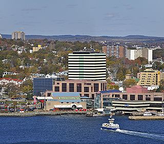
Dartmouth is a built-up community of Halifax Regional Municipality, Nova Scotia, Canada. Located on the eastern shore of Halifax Harbour, Dartmouth has 72,139 residents as of 2021.

<span class="mw-page-title-main">Halifax, Nova Scotia</span> Capital and most populous municipality of Nova Scotia, Canada

Halifax is the capital and largest municipality of the Canadian province of Nova Scotia, and the largest municipality in Atlantic Canada. As of 2022, it is estimated that the population of the Halifax CMA was 480,582, with 348,634 people in its urban area. The regional municipality consists of four former municipalities that were amalgamated in 1996: Halifax, Dartmouth, Bedford, and Halifax County.

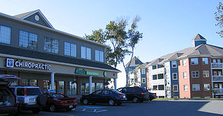
Hammonds Plains is a suburban area of the Halifax Regional Municipality in Nova Scotia, Canada, located 20 km northwest of Downtown Halifax.

Spryfield is community within the urban area of Halifax, Nova Scotia, Canada.

<span class="mw-page-title-main">North End, Halifax</span> Subdivision in Nova Scotia, Canada

The North End of Halifax is a neighbourhood of Halifax, Nova Scotia occupying the northern part of Halifax Peninsula immediately north of Downtown Halifax.

<span class="mw-page-title-main">Eastern Passage, Nova Scotia</span> Community in Nova Scotia, Canada

Eastern Passage is an unincorporated suburban community in Halifax Regional Municipality Nova Scotia, Canada.

<span class="mw-page-title-main">South End, Halifax</span> Neighbourhood in Halifax, Nova Scotia, Canada

The South End is a neighbourhood within Halifax's urban area, in the Municipality of Halifax, Nova Scotia, Canada.

<span class="mw-page-title-main">Lower Sackville, Nova Scotia</span> Community in Nova Scotia, Canada

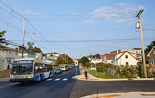
Lower Sackville is a suburban community of the Halifax Regional Municipality, Nova Scotia, Canada.

<span class="mw-page-title-main">Clayton Park, Nova Scotia</span> Community in Nova Scotia, Canada

Clayton Park is a community within Halifax, Nova Scotia, Canada.

<span class="mw-page-title-main">Chebucto Peninsula</span> Peninsula in Nova Scotia, Canada

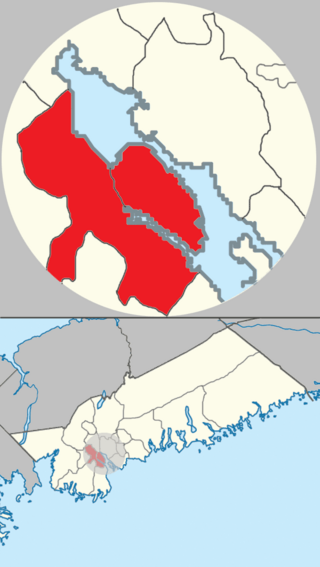
The Chebucto Peninsula is a peninsula located in central Nova Scotia, Canada, entirely within the Halifax Regional Municipality on the Atlantic coast.

The Halifax Regional Municipality (HRM) in Nova Scotia, Canada has a widely varied geography.

<span class="mw-page-title-main">History of Halifax, Nova Scotia</span> Aspect of history

The community of Halifax, Nova Scotia was created on 1 April 1996, when the City of Dartmouth, the City of Halifax, the Town of Bedford, and the County of Halifax amalgamated and formed the Halifax Regional Municipality. The former City of Halifax was dissolved, and transformed into the Community of Halifax within the municipality.

Timberlea is a community located within the Municipality of Halifax in Nova Scotia, Canada.

<span class="mw-page-title-main">Fairview, Nova Scotia</span> Urban Community in Nova Scotia, Canada

Fairview is a community within the urban area of Halifax in Nova Scotia, Canada.

<span class="mw-page-title-main">Barrington Street</span> Road in Halifax, Nova Scotia, Canada

Barrington Street is a major street in Halifax, Nova Scotia, Canada, running from the MacKay Bridge in the North End approximately 7 km south, through Downtown Halifax to Inglis Street in the South End. Its civic numbers range from 950 to 4756 on the Halifax Peninsula street grid numbering system.

Terence Bay is a rural fishing community on the Chebucto Peninsula in the Halifax Regional Municipality, Nova Scotia. It is located on the shore of the Atlantic Ocean, 10 km off the Prospect Road, off Route 333, 21.2 kilometers from Halifax.

<span class="mw-page-title-main">Chebucto Community Net</span>

The Chebucto Community Net (CCN) is a Canadian FreeNet operating in Nova Scotia's Halifax Regional Municipality (HRM). It is registered as a non-profit society under Nova Scotia's Registry of Joint Stocks using the name Chebucto Community Net Society. The name "Chebucto" comes from the local l'nu word for Halifax Harbour meaning "big water".

<span class="mw-page-title-main">Timeline of Halifax, Nova Scotia history</span>

This timeline of the history of the Halifax Regional Municipality documents all events that had happened in Halifax, Nova Scotia, Canada, including historical events in the former city of Dartmouth, the Town of Bedford and Halifax County. Events date back to the early 18th century and continue until the present in chronological order.

Herring Cove is a Canadian suburban and former fishing community in Nova Scotia's Halifax Regional Municipality. It is situated on the eastern shore of the Chebucto Peninsula, 15 km (9.3 mi) south of Downtown Halifax. It is near the western approaches to Halifax Harbour, and can be reached both via Purcell's Cove along the coastal road and from inland via the Herring Cove Road through Spryfield. There are two schools in Herring Cove, William King Elementary and Herring Cove Junior High. The community is also home to a small variety of small businesses and programs.

Joachim Stroink is a Canadian politician, who was elected to the Nova Scotia House of Assembly in the 2013 provincial election. A member of the Nova Scotia Liberal Party, he represented the electoral district of Halifax Chebucto until 2017.

References

  1. "Census 2021 Census Tracts". HRM Open Data. Government of the Municipality of Halifax. Retrieved 10 August 2022.
  2. "Census 2021 Census Tracts". HRM Open Data. Government of the Municipality of Halifax. Retrieved 10 August 2022.
  3. Beck, J. Murray (1979). "Cornwallis, Edward". In Halpenny, Francess G (ed.). Dictionary of Canadian Biography . Vol. IV (1771–1800) (online ed.). University of Toronto Press.
  4. http://sis.agr.gc.ca/cansis/publications/surveys/ns/ns13b/%7CSoil%5B%5D Survey of Halifax County Nova Scotia
  5. "Census 2021 Census Tracts". HRM Open Data. Government of the Municipality of Halifax. Retrieved 10 August 2022.
  6. "Census 2021 Census Tracts". HRM Open Data. Government of the Municipality of Halifax. Retrieved 10 August 2022.
  7. "Census 2016 Census Tracts". HRM Open Data. Government of the Municipality of Halifax. Retrieved 10 August 2022.
  8. "Routes & Schedules". halifax.ca. Government of the Municipality of Halifax. Retrieved 10 August 2022.
  9. "Routes & Schedules". Halifax. Government of the Municipality of Halifax. 14 March 2023. Retrieved 5 April 2023.
  10. "Atlantic Provinces Special Education Authority". apsea.ca. Atlantic Provinces Special Education Authority. Retrieved 8 August 2022.