Musquodoboit Harbour, Nova Scotia

Last updated
Musquodoboit Harbour
DSC03070 - Musquodoboit Harbour Lighthouse (44254609604).jpg
Musquodoboit Harbour Lighthouse
Canada Nova Scotia location map 2.svg
Red pog.svg
Location in Nova Scotia
Coordinates: 44°47′14″N63°8′55″W / 44.78722°N 63.14861°W / 44.78722; -63.14861
Country Canada
Province Nova Scotia
County Halifax County
Population
  Total2,139
 [ citation needed ]

Musquodoboit Harbour is a rural community located in Nova Scotia, Canada within the Halifax Regional Municipality. The community is situated on the Eastern Shore at the mouth of the Musquodoboit River. The community lies 45 kilometres east of downtown Halifax. With a hospital, RCMP detachment, postal outlet, schools, recreational center, library, municipal office and other services, Musquodoboit Harbour is a serve centre for many of the surrounding communities.

Contents

Etymology

Musquodoboit means foaming to the sea, flowing out square or rolling out in foam, or suddenly widening out after a narrow entrance at its mouth. The community is an anglicized version of the Mi’kmaq word Moosekudoboogwek or Muskoodeboogwek.

History

The local railway station is now a museum MusqHbrStn 2010.jpg
The local railway station is now a museum

The community was settled in the 1780s mainly by Loyalists. Through the late 18th and early 19th centuries many settlers from Scotland, England and Germany immigrated to the area and they still have descendants in the area, evidenced by prominent family names such as Tibbo, Rowlings, Anderson, Gaetz, and Bayers.

Transportation history

Much early travel was by water as roads were rough. Beginning in 1852, the stage coach travelled from Musquodoboit Harbour to Dartmouth at a cost of 5 shillings. The first automobile was owned by Dr. Kennedy in 1909. The Dartmouth Eastern Railway commenced in 1912 to carry lumber and lime from Middle Musquodoboit to Dartmouth. A station was completed in 1918 and today houses the Musquodoboit Harbour Railway Museum, which also serves as the local tourism office in summer. The museum grounds contain a passenger car, snow plow from the Dominion Atlantic Railway and a caboose from the Canadian National Railway. The museum is on the Canadian Register of Historic Places. [1]

Other services

The Rural Telephone system came into use around 1909.

The Fire Department

It all began one evening in 1957 when Garth Young was sitting at the table playing crib with friends. His sister ran in and said she could see flames in a window upstairs as she was driving down the road. Garth and his father each grabbed a bucket of water and ran upstairs, but there was nothing they could do. There was no fire department in Musquodoboit Harbour. They called Lands and Forests (now called the Department of Natural Resources) who showed up later with a portable pump and some hose. But by now, the two-story house was in flames and the dozen family members who lived there could only watch helplessly as it burned to the ground. The loss motivated Garth Young and other people in the community to establish their own fire department. By 1960 Garth Young was clearing land for the new station. A year later the Musquodoboit Harbour Volunteer Fire Department was born and he became one of its original members. The Musquodoboit Harbour Volunteer Fire Department formed in 1961 with the fire hall opening on October 6, 1964. The first piece of equipment they had was a trailer with a pump on it. It had compartments on each side into which they were able to put extra equipment, such as hoses. The first truck they had was a 1957 milk truck that they bought in 1963 from a farmer. The Fire Department Ladies Auxiliary formed in February 1967.[ citation needed ]

In 1996, Halifax, Dartmouth, Bedford, and the County of Halifax amalgamated into what is today the Halifax Regional Municipality. Dozens of fire departments merged into the Halifax Regional Fire & Emergency Services, and the Musquodoboit Harbour Volunteer Fire Department received the designation of "Halifax Regional Fire & Emergency, Station 24." On June 13, 2008, The station was actively involved in the Porter's Lake fire, one of the biggest forest fire in Nova Scotia's history. Members spent 5 days working side-by-side with the Department of Natural Resources. On October 6, 2008, the station was staffed with career personnel for the very first time. From October 6, 2008 to December 31, 2008, the crew was made up of a career Lieutenant and a casual worker taken from the station's own volunteers. On January 1, 2009 the station was officially staffed with career personnel, Monday to Friday, with anywhere between 2 and 4 people, depending on the needs.[ citation needed ]

Martinique Beach Provincial Park

Located at the end of the East Petpeswick Rd, Martinique Beach is the longest sandy beach in Nova Scotia. This 5 kilometre long beach is a provincial park which boasts both picnic and swimming facilities. The excellent surf conditions at Martinique Beach draw in surfers from all over. The beach is named after Prince Edward who took part in the 1794 Capture of Martinique. [2] [3]

There is a wildlife sanctuary adjacent to Martinique Beach. Canada Geese and Black Ducks can often be seen during migratory periods. There is even a protected nesting area for the Piping Plover, an endangered species.

The site is an Important Bird Area. [4]

Yacht Club

Just 2 kilometers down the East Petpeswick Road is Petpeswick Yacht Club. PYC is home to a learn-to-sail program, small marina and a kayaking program. The yacht club hosts an annual regatta-the Shearwater to Petpeswick Race, Canada Day festivities and a number of dances and social events throughout the year. The clubhouse was newly renovated in 2011 and is available for private hire.


Healthcare

The Twin Oaks Memorial Hospital, which opened in 1976, is located on Highway 7. It has a 24-hour emergency department and provides a variety of outpatient and inpatient services.

Churches

Transportation

Communications

Demographics

Schools

Related Research Articles

<span class="mw-page-title-main">Dartmouth, Nova Scotia</span> Urban community in Canada

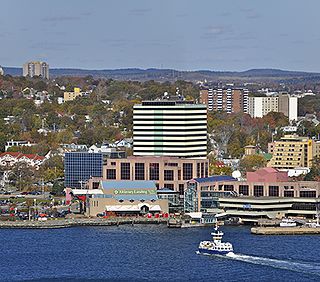
Dartmouth is a built-up community of Halifax Regional Municipality, Nova Scotia, Canada. Located on the eastern shore of Halifax Harbour, Dartmouth has 72,139 residents as of 2021.

<span class="mw-page-title-main">Sackville—Preston—Chezzetcook</span> Federal electoral district in Nova Scotia, Canada

Sackville—Preston—Chezzetcook is a federal electoral district in Halifax, Nova Scotia, Canada, that has been represented in the House of Commons of Canada since 1997.

<span class="mw-page-title-main">Halifax, Nova Scotia</span> Capital and most populous municipality of Nova Scotia, Canada

Halifax is the capital and largest municipality of the Canadian province of Nova Scotia, and the largest municipality in Atlantic Canada. As of 2022, it is estimated that the population of the Halifax CMA was 480,582, with 348,634 people in its urban area. The regional municipality consists of four former municipalities that were amalgamated in 1996: Halifax, Dartmouth, Bedford, and Halifax County.

<span class="mw-page-title-main">Halifax Harbour</span> Harbour in Nova Scotia, Canada

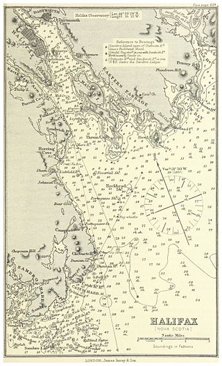
Halifax Harbour is a large natural harbour on the Atlantic coast of Nova Scotia, Canada, located in the Halifax Regional Municipality. Halifax largely owes its existence to the harbour, being one of the largest and deepest ice-free natural harbours in the world. Before Confederation it was one of the most important commercial ports on the Atlantic seaboard. In 1917, it was the site of the world's largest man-made accidental explosion, when the SS Mont-Blanc blew up in the Halifax Explosion of December 6.

<span class="mw-page-title-main">Nova Scotia Highway 107</span> Highway in Nova Scotia

Highway 107 in Nova Scotia runs through the eastern suburbs of the Halifax Regional Municipality, from the Burnside Industrial Park in Dartmouth to an intersection with Trunk 7 in Musquodoboit Harbour. It is 43.2 km (26.8 mi) long, and is mostly two lane, controlled access highway.

<span class="mw-page-title-main">Eastern Shore (Nova Scotia)</span> Region of Nova Scotia

The Eastern Shore is a region of the Canadian province of Nova Scotia. It is the Atlantic coast running northeast from Halifax Harbour to the eastern end of the peninsula at the Strait of Canso.

The Halifax Regional Municipality (HRM) in Nova Scotia, Canada has a widely varied geography.

<span class="mw-page-title-main">History of Halifax, Nova Scotia</span> Aspect of history

The community of Halifax, Nova Scotia was created on 1 April 1996, when the City of Dartmouth, the City of Halifax, the Town of Bedford, and the County of Halifax amalgamated and formed the Halifax Regional Municipality. The former City of Halifax was dissolved, and transformed into the Community of Halifax within the municipality.

<span class="mw-page-title-main">Musquodoboit Valley</span> Valley in Nova Scotia, Canada

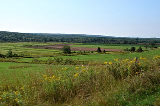
The Musquodoboit Valley is a valley and region in the Halifax Regional Municipality of Nova Scotia, Canada. It is administratively located in the municipality's Musquodoboit Valley & Dutch Settlement planning area and the western edge of the valley includes communities that are considered part of the commutershed for the urban area of the Halifax Regional Municipality. The picturesque Musquodoboit River flows through majority of the valley, passing by most of the communities in the valley. The river is approximately 97 kilometres (60 mi) long and originates in the extreme northeastern area of the valley. The three largest communities in the valley are Upper Musquodoboit, Middle Musquodoboit and Musquodoboit Harbour. The word "Musquodoboit" is derived from the Mi’kmaq language and means "rolling out in foam".

<span class="mw-page-title-main">Nova Scotia Trunk 7</span> Highway in Nova Scotia

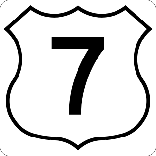
Nova Scotia Trunk 7 is part of the Canadian province of Nova Scotia's system of Trunk Highways. The route runs from Bedford to Antigonish, along the Eastern Shore for a distance of 269 kilometres (167 mi). Part of Trunk 7 is known as the Marine Drive.

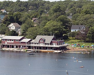
Musquodoboit Harbour is a natural harbour in Canada on the Eastern Shore of Nova Scotia.

<span class="mw-page-title-main">Middle Musquodoboit, Nova Scotia</span> Place in Nova Scotia, Canada

Middle Musquodoboit is a rural community in the Musquodoboit Valley region of Nova Scotia, Canada within the Halifax Regional Municipality, along the Musquodoboit River at the junction of Route 357 with Route 224, 78 kilometres (48 mi) from Dartmouth, Nova Scotia. The community's name comes from the First Nations' word Mooskoduboogwek, which means to suddenly widen out after a narrow entrance at a mouth. For a time after 1883, Middle Musquodoboit was called Laytonville, but at some point reverted to its former name.

<span class="mw-page-title-main">Sport in Halifax, Nova Scotia</span>

Halifax, Nova Scotia, with the largest urban population in Atlantic Canada, is a major sporting centre.

The Halifax Regional Municipality (HRM) is a major generator of economic activity in Atlantic Canada.

<span class="mw-page-title-main">Government in Halifax, Nova Scotia</span>

Halifax Regional Municipality, formally known as Halifax is located in Nova Scotia, Canada. The municipality is governed by a mayor and a sixteen-person Regional Council, who are elected by geographic district; municipal elections occur every leap year.

Dartmouth founded in 1750, is a Metropolitan Area and former city in the Canadian province of Nova Scotia.

<span class="mw-page-title-main">Halifax Regional Fire and Emergency</span> Fire and emergency service provider in Nova Scotia, Canada

Halifax Regional Fire and Emergency Services provides fire protection, rescue and first responder assistance throughout Halifax, Nova Scotia, Canada.

The Capital District Health Authority was the largest of the nine health authorities in the Canadian province of Nova Scotia. In 2015 it was merged into the new, province-wide Nova Scotia Health Authority.

<span class="mw-page-title-main">Upper Lakeville</span>

Upper Lakeville is a small cottage community on the Eastern Shore, which includes a blend of summer cottages and year-round homes. It is located on the Western shore of Lake Charlotte. Upper Lakeville is one of the many small rural communities that are included in the Halifax Regional Municipality Nova Scotia. Upper Lakeville road is located at its junction with Trunk 7, 55.3 km from Dartmouth, Nova Scotia, and 58.9 km from the City of Halifax, on the stretch of Marine Drive running between Musquodoboit Harbour and Sheet Harbour. It terminates at E & F Webber Lakeside Park campgrounds. The only public access to the lake in Upper Lakeville is at E & F Webber Lakeside Park campgrounds.

<span class="mw-page-title-main">Outline of Nova Scotia</span> Overview of and topical guide to Nova Scotia

The following outline is provided as an overview of and topical guide to Nova Scotia:

References

  1. http://www.historicplaces.ca/visit-visite/affichage-display.aspx?id=5334 Canadian Register of Historic Places.
  2. "Prince Edward and Nova Scotia".
  3. Note. There is also the possibility that it was named after Lt Governor of Nova Scotia George Prévost Invasion of Martinique (1809).
  4. "IBA Site Listing". www.ibacanada.org. Retrieved 2021-02-03.
  5. "DISTRICT PROFILE | Councillor David Hendsbee".