Prior to European colonization, the Mi'kmaq lived on the land for thousands of years.
In the 1750s, many of the Foreign Protestants settled in the area. First known as the Westerwald ("western forest"), the settlement was called the Dutch Village by non-German locals. Some of the passengers of the Foreign Protestant ships settled temporarily in the Dutch Village while they waited for a more permanent settlement in Lunenburg County.
In the early 20th century, most of the current street network in the area was established. It formed a regular grid pattern up the eastern slope of Geizers Hill, facing toward the Bedford Basin and the Halifax peninsula.
After World War I, the railway lines in the Fairview area came under control of Canadian National Railways. Canadian National Railways established its new locomotive servicing shops and roundhouse for the Halifax area in the community, which was named Fairview Station on 1 March 1921. Until the 1950s, the majority of Fairview's residents were employed by the railway.
The community name was shortened to Fairview on 19 January 1956.
In 1958, Fairview became home to Halifax West Municipal High School (later changed to Halifax West High School in 1969), located on Dutch Village Road.
In the early 1960s, to construct the inner-urban portion of Highway 102, all of the homes on School Avenue's southern side were appropriated—and subsequently demolished—by the province. School Avenue itself is still owned by the province of Nova Scotia and is the only civic street in the area not under municipal authority.
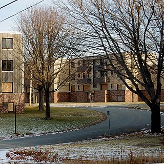
Through the 1960s, Fairview continued to fill in and its housing densified. During the late 1960s and early 1970s, Fairview developed into a major shopping destination after Halifax's first suburban shopping mall, the Bayers Road Shopping Centre, was constructed.
Newer residential developments in outlying areas during the 1970s-1990s, such as the modern development in adjacent Clayton Park, along with a demand by families for larger homes, saw Fairview's working-class neighbourhoods of smaller homes become a less desirable location over time. The last subdivision to be completed in the community was Keystone Court in 1990.
On 1 April 1996, Halifax County was dissolved and all of its places (cities, suburbs, towns, and villages) were turned into communities of a single-tier municipality named Halifax Regional Municipality. Subsequently, Fairview turned into a community within the new Municipality of Halifax.
In honour of the original settlement, a section of Dutch Village Road—which had been an exit to Highway 102—was renamed Westerwald Street in November 2002. Dutch Village Road/Westerwald Street now form the main commercial street at the foot of Fairview's slope, the corner of Westerwald Street, Bayers Road to the basin end of Joseph Howe Drive.
Geography
Dutch Village Road at the intersection of Rosedale Avenue in the summer of 2023.
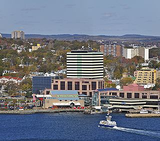
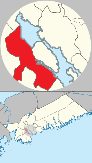
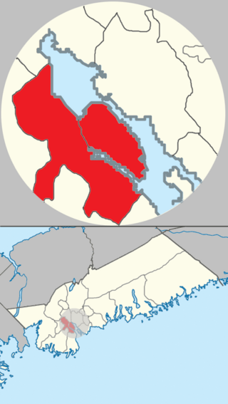
Fairview is named after Fairview Cove, which forms the extreme southern end of Bedford Basin at the northern edge of the isthmus connecting the Chebucto Peninsula to the Halifax Peninsula. Its landmass is approximately 218.1ha (539 acres).[3] As such, Fairview sits astride and is bisected by several major transportation corridors:
Bayers Road, which used to run from Halifax's North End neighbourhood to Bayers Lake, a freshwater lake northwest of Fairview - and now runs to an intersection with Joseph Howe Drive
Dutch Village Road, which in 2002 was shortened to operate as a small loop through the old business district in Fairview - it originally ran along much of the alignment for Joseph Howe Drive
Highway 102 expressway, (Bicentennial Drive or "Bi-Hi") which crosses through the neighbourhood on a 1960s-era overpass which crosses several major streets and rail lines
Trunk 2, (the Bedford Highway), which has its southern terminus in Fairview along the shore of Bedford Basin and connects to the North End community of Halifax via the 1950s-era Fairview Overpass
Joseph Howe Drive, which runs the length of the Halifax Peninsula's isthmus
Demographics
According to the 2021 Halifax Census Tract Map, more specifically Census Tract 2050024.00, Fairview has about 8,618 people over a landmass of approximately 2.181km2 (0.842sqmi).[4]
The community (Census Tract 2050024.00) is one of the fastest-growing communities in Halifax. From 2016 to 2021 the community grew 16.9% from 7,375 people in 2016 to 8,618 people in 2021.[5] Additionally, Fairview is also one of the densest communities within Halifax—and its population density increased from approximately 33 people per hectare (3,300 people per km2) in 2016,[6] to approximately 39 people per hectare (3,900 people per km2) in 2021.[7]
The community food bank is located at the Salvation Army on 50 Gesner Street.
The Masonic Lodge (formerly Saint Pius X Church) is at 165 Coronation Avenue. Home of the oldest Masonic Lodge in the British Commonwealth outside England itself. Saint Andrew's Lodge No.1 established in 1750 A.D.[10]
Dartmouth is a built-up community of Halifax Regional Municipality, Nova Scotia, Canada. Located on the eastern shore of Halifax Harbour, Dartmouth has 72,139 residents as of 2021.
Halifax is the capital and most populous municipality of the Canadian province of Nova Scotia, and the most populous municipality in Atlantic Canada. As of 2022, it is estimated that the population of the Halifax CMA was 480,582, with 348,634 people in its urban area. The regional municipality consists of four former municipalities that were amalgamated in 1996: Halifax, Dartmouth, Bedford, and Halifax County.
Bedford is a former town and now a district of Halifax, Nova Scotia, Canada. It is situated on the north west shore of the Bedford Basin in the central area of the municipality. It borders the neighbouring communities of Hammonds Plains to the west, Sackville to the north, Dartmouth to the east, and Main Land Halifax to the south. Bedford was named in honour of John Russell, 4th Duke of Bedford, Secretary of State for the colonies in 1749.
Mainland Halifax is the remaining portion of the community of Halifax, without the Halifax Peninsula.
The Halifax Peninsula is a peninsula within the urban area of the Municipality of Halifax, Nova Scotia.
The South End is a neighbourhood within Halifax's urban area, in the Municipality of Halifax, Nova Scotia, Canada.
Fall River is a suburban community located in Nova Scotia, Canada within the Halifax Regional Municipality. It is located north-northeast of the Bedford Basin, northeast of Bedford and Lower Sackville and north of Waverley.
Waverley is a suburban community of the Halifax Regional Municipality, in Nova Scotia, Canada. It has a rich history in gold mining. It lies north of Dartmouth, and south of Fall River.
Lakeview is a community of Halifax Regional Municipality, Nova Scotia, Canada.
Campbell's Bay is a municipality in Pontiac Regional County Municipality in western Quebec, Canada. Its population in 2021 was 705.
Highway 102 is a north–south highway in the Canadian province of Nova Scotia that runs from Halifax to Onslow, immediately north of the town of Truro. It is the busiest highway in Atlantic Canada.
Clayton Park is a community within Halifax, Nova Scotia, Canada.
Rockingham is a community located within the urban area of the Halifax Regional Municipality, in Nova Scotia, Canada.
The Halifax Regional Municipality (HRM) in Nova Scotia, Canada has a widely varied geography.
The community of Halifax, Nova Scotia was created on 1 April 1996, when the City of Dartmouth, the City of Halifax, the Town of Bedford, and the County of Halifax amalgamated and formed the Halifax Regional Municipality. The former City of Halifax was dissolved, and transformed into the Community of Halifax within the municipality.
Timberlea is a community located within the Municipality of Halifax in Nova Scotia, Canada.
Shannon Park is an urban neighbourhood and former national defence site in the north end of Dartmouth on the eastern shore of Halifax Harbour in the Halifax Regional Municipality (HRM) in Nova Scotia, Canada. It is immediately south of the A. Murray MacKay Bridge in the community of Dartmouth. It straddles Highway 111, a CN Rail freight line, and Halifax Harbour. It is bordered on the south by Tuft's Cove.
Terence Bay is a rural fishing community on the Chebucto Peninsula in the Halifax Regional Municipality, Nova Scotia. It is located on the shore of the Atlantic Ocean, 10 km off the Prospect Road, off Route 333, 21.2 kilometers from Halifax.
Boutiliers Point is a rural community in the Halifax Regional Municipality on the shore of the Atlantic Ocean on Trunk 3, 27.61 kilometers from Halifax.
The amalgamation of four municipalities on April 1, 1996, was the creation of the Halifax Regional Municipality, Nova Scotia, Canada. It resulted in the regional municipality's current boundaries.
References
Devonna and Don Edwards, The Little Dutch Village: Historic Halifax West - Armdale and Fairview, Halifax: Nimbus Publishing, 2003
"Bell, Winthrop Pickard, The "Foreign Protestants" and the Settlement of Nova Scotia: The History of a piece of arrested British Colonial Policy in the Eighteenth Century, Toronto: University of Toronto Press, 1961
↑ "Census 2021 Census Tracts". HRM Open Data. Government of the Municipality of Halifax/Statistics Canada. Retrieved 16 July 2022.
↑ "Census 2021 Census Tracts". HRM Open Data. Government of the Municipality of Halifax/Statistics Canada. Retrieved 16 July 2022.
↑ "Census 2021 Census Tracts". HRM Open Data. Government of the Municipality of Halifax/Statistics Canada. Retrieved 16 July 2022.
↑ "Census 2021 Census Tracts". HRM Open Data. Government of the Municipality of Halifax/Statistics Canada. Retrieved 16 July 2022.
↑ "Census 2021 Census Tracts". HRM Open Data. Government of the Municipality of Halifax/Statistics Canada. Retrieved 16 July 2022.
↑ "Census 2016 Census Tracts". HRM Open Data. Government of the Municipality of Halifax/Statistics Canada. Retrieved 16 July 2022.
↑ "Census 2021 Census Tracts". HRM Open Data. Government of the Municipality of Halifax/Statistics Canada. Retrieved 16 July 2022.
↑ "Census 2016 Census Tracts". HRM Open Data. Government of the Municipality of Halifax/Statistics Canada. Retrieved 16 July 2022.
↑ "Census 2021 Census Tracts". HRM Open Data. Government of the Municipality of Halifax/Statistics Canada. Retrieved 16 July 2022.
This page is based on this Wikipedia article Text is available under the CC BY-SA 4.0 license; additional terms may apply. Images, videos and audio are available under their respective licenses.