South End, Halifax

Last updated
South End
Neighbourhood
Dalhousie Vines.jpg
The vine-covered Henry Hicks building at Dalhousie University
Country Canada
Province Nova Scotia
Municipality Halifax
Community Halifax
Municipal District District 7 (Halifax South Downtown)
Area Codes 782, 902

The South End is a neighbourhood within Halifax's urban area, in the Municipality of Halifax, Nova Scotia, Canada.

Contents

History

The areas south of South Street and west of the South Common were largely farmland and mixed-forest which led to the development of large estates that took advantage of their proximity to the former City of Halifax and garrison.

Over time, neighbourhoods began to develop outside the original city boundary and were annexed by the city.

In 1918, one of Halifax's largest projects saw the completion of a major railway line, to serve a new railway station at the south end of the city's central business district. The new railway line had been under construction by the Intercolonial Railway and later Canadian Government Railways at the time of the Halifax Explosion, which blocked and badly damaged the city's North Street station. The project created an approximately 30 m (98 ft) deep rock-cut for several kilometres, parallel the shore of the Northwest Arm. The new railway line through the South End was rushed into completion to accommodate the unexpected disaster. One result of the building of this railway line has been to geographically isolate parts of the peninsula, creating opportunities for wealthy and exclusive neighbourhoods to develop. Another legacy of the blasting work created during the construction of the South End railway cut was the infilling of parts of the Bedford Basin and Halifax Harbour to create freight-and-passenger ship docks, and railway yards.

Geography

The South End is located on the southern half of the Halifax Peninsula. The neighbourhood was originally bounded on the south by South Street and was the few blocks located south of Citadel Hill.

Demographics

The South End has become the most prosperous region of Halifax, with a middle-class demographic. [1]

The neighbourhood contains Halifax's densest census tract; census tract 2050004.02. Although the census tract has a small landmass of approximately 48.2 ha (119 acres), [2] 5,466 people live within the area. [3] The population density is approximately 113 people per hectare (approximately 11,300 people per km2). [4]

Parks and recreation

Throughout the neighbourhood, the South End has many places where recreational activities can be enjoyed.

Sports Complexes

Community Centres

Fields

Libraries

There are several academic libraries in the South End.

Museums

Parks

Pools

Trails

Transportation

The South End of Halifax is in a dense part of the Municipality of Halifax with different ways to travel.

There are many kilometres of avenues, lanes, roads, and streets that criss-cross throughout the neighbourhood. Robie Street which bisects the neighbourhood, and starts in the South End, is the main thoroughfare through the neighbourhood-and-the Halifax Peninsula. It runs approximately 4 km (2.5 mi), and eventually continues-on as Massachusetts Avenue.

On 1161 Hollis Street, Via Rail operates Halifax station.

The neighbourhood is serviced by many public transit routes, which is provided by Halifax Transit.

Halifax Transit Routes [5]

Education

Within the South End, there are several levels of education available.

Inclusive education

The Halifax School for the Blind is administered by the Atlantic Provinces Special Education Authority (APSEA). [6]

Private schools

Public schools

With the exception of the Conseil scolaire acadien provincial, all other public schools within the South End are administered by the Halifax Regional Centre for Education.

Conseil scolaire acadien provincial

Elementary Schools

High Schools

Junior High Schools

Universities

Related Research Articles

<span class="mw-page-title-main">Dartmouth, Nova Scotia</span> Urban community in Canada

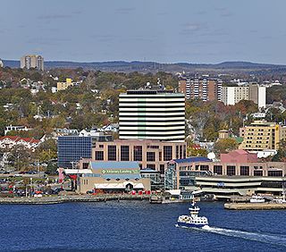
Dartmouth is a built-up community of Halifax Regional Municipality, Nova Scotia, Canada. Located on the eastern shore of Halifax Harbour, Dartmouth has 72,139 residents as of 2021.

<span class="mw-page-title-main">Halifax, Nova Scotia</span> Capital and most populous municipality of Nova Scotia, Canada

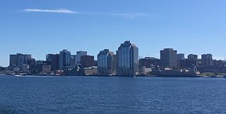
Halifax is the capital and largest municipality of the Canadian province of Nova Scotia, and the largest municipality in Atlantic Canada. As of 2022, it is estimated that the population of the Halifax CMA was 480,582, with 348,634 people in its urban area. The regional municipality consists of four former municipalities that were amalgamated in 1996: Halifax, Dartmouth, Bedford, and Halifax County.

Spryfield is community within the urban area of Halifax, Nova Scotia, Canada.

<span class="mw-page-title-main">Mainland Halifax</span> Place in Nova Scotia, Canada

Mainland Halifax is the remaining portion of the community of Halifax, without the Halifax Peninsula.

<span class="mw-page-title-main">North End, Halifax</span> Subdivision in Nova Scotia, Canada

The North End of Halifax is a neighbourhood of Halifax, Nova Scotia occupying the northern part of Halifax Peninsula immediately north of Downtown Halifax.

<span class="mw-page-title-main">Halifax Peninsula</span> Place in Nova Scotia, Canada

The Halifax Peninsula is a peninsula within the urban area of the Municipality of Halifax, Nova Scotia.

<span class="mw-page-title-main">Lower Sackville, Nova Scotia</span> Community in Nova Scotia, Canada

Lower Sackville is a suburban community of the Halifax Regional Municipality, Nova Scotia, Canada.

Middle Sackville is a suburban community located in Halifax Regional Municipality in Nova Scotia, Canada. It was named after George Germain, 1st Viscount Sackville.

<span class="mw-page-title-main">Halifax Common</span>

The Halifax Common, in local popular usage often referred to as the Commons, is a Canadian urban park in Halifax, Nova Scotia. It is Canada’s oldest urban park.

<span class="mw-page-title-main">Clayton Park, Nova Scotia</span> Community in Nova Scotia, Canada

Clayton Park is a community within Halifax, Nova Scotia, Canada.

<span class="mw-page-title-main">Downtown Halifax</span> Downtown Area in Nova Scotia, Canada

Downtown Halifax is the primary central business district of the Municipality of Halifax. Located on the central-eastern portion of the Halifax Peninsula, on Halifax Harbour. Along with Downtown Dartmouth, and other de facto central business districts within the Municipality, Downtown Halifax serves as the business, entertainment, and tourism hub of the region.

Rockingham is a community located within the urban area of the Municipality of Halifax, in Nova Scotia, Canada.

Timberlea is a community located within the Municipality of Halifax in Nova Scotia, Canada.

<span class="mw-page-title-main">Shannon Park, Nova Scotia</span> Neighbourhood in Halifax Regional Municipality, Nova Scotia, Canada

Shannon Park is an urban neighbourhood and former national defence site in the north end of Dartmouth on the eastern shore of Halifax Harbour in the Halifax Regional Municipality (HRM) in Nova Scotia, Canada. It is immediately south of the A. Murray MacKay Bridge in the community of Dartmouth. It straddles Highway 111, a CN Rail freight line, and Halifax Harbour. It is bordered on the south by Tuft's Cove.

<span class="mw-page-title-main">Clanton Park, Toronto</span> Neighbourhood in Toronto, Ontario, Canada

Clanton Park is a neighbourhood in Toronto, Ontario, Canada. Located in the district of North York, it is part of federal and provincial electoral district York Centre, and Toronto electoral wards 9: York Centre (West) and 10: York Centre (East). In 2016, it had a population of 16,472, a 12.7% rise from 2011.

<span class="mw-page-title-main">Fairview, Nova Scotia</span> Urban Community in Nova Scotia, Canada

Fairview is a community within the urban area of Halifax in Nova Scotia, Canada.

<span class="mw-page-title-main">Robie Street</span> Road in Halifax, Nova Scotia, Canada

Robie Street is a north-south artery that runs for 7 km in the Halifax Peninsula area of the Halifax Regional Municipality from Memorial Drive in the North End to Gorsebrook Avenue in the South End.

<span class="mw-page-title-main">Education in Halifax, Nova Scotia</span>

Halifax, Nova Scotia has the largest selection of education options in Atlantic Canada.

Lakeside is a community within the urban area of the Municipality of Halifax in Nova Scotia.

<span class="mw-page-title-main">Gorsebrook Park</span>

Gorsebrook Park is a 19-acre Canadian urban park located in the South End of Halifax, Nova Scotia.

References

  1. South End (Halifax) - Canada's wealthiest neighbourhoods Archived 2014-05-04 at the Wayback Machine MSN Money
  2. "Census 2021 Census Tracts". HRM Open Data. Government of the Municipality of Halifax. Retrieved 8 August 2022.
  3. "Census 2021 Census Tracts". HRM Open Data. Government of the Municipality of Halifax. Retrieved 8 August 2022.
  4. "Census 2021 Census Tracts". HRM Open Data. Government of the Municipality of Halifax. Retrieved 8 August 2022.
  5. "Routes & Schedules". halifax.ca. Government of the Municipality of Halifax/Halifax Transit. Retrieved 8 August 2022.
  6. "Atlantic Provinces Special Education Authority". apsea.ca. Atlantic Provinces Special Education Authority. Retrieved 8 August 2022.

44°38′5.9″N63°34′58.9″W / 44.634972°N 63.583028°W / 44.634972; -63.583028