Burnside, Nova Scotia

Last updated
Burnside
BurnsidePark-1-2.jpg
Map of Burnside Park
Burnside, Nova Scotia
Location within Dartmouth
Canada Nova Scotia location map 2.svg
Red pog.svg
Location within Nova Scotia
Coordinates: 44°42′6″N63°36′2″W / 44.70167°N 63.60056°W / 44.70167; -63.60056 [1]
Country Canada
Province Nova Scotia
Municipality Halifax Regional Municipality
Community Dartmouth
Community council Harbour East - Marine Drive Community Council
District6 - Harbourview - Burnside - Dartmouth East
Area
[2]
  Total13.76 km2 (5.31 sq mi)
Postal code
B3B
Telephone Exchanges 902 468
GNBC codeCAFMT

Burnside is a Canadian urban neighbourhood located along the northeast shore of Bedford Basin of the Halifax Regional Municipality in Dartmouth, Nova Scotia.

Contents

History

Burnside was the name originally given to the farm of Duncan Waddell, a Scotsman who had settled the area. Burn comes from the Scottish word for "stream", since one flowed through the property. Gradually, his land was sold off to various industries, including National Gypsum, a brickyard, a steel company, an oil terminal, and the Bedford Magazine. [3]

More recently, Burnside has been the location of a major concentration of industry and commercial development since the 1970 completion of the A. Murray MacKay Bridge near the previously existing Industrial Estate, which had only 4 enterprises prior to the bridge opening. There are very few dwellings in Burnside as it is used almost exclusively for commercial operations; the only residential areas being the adjacent communities of Highfield Park, Albro Lake and Wright's Cove.

Burnside Industrial Park was formally opened by Dartmouth mayor Roland J. Thornhill in December 1969. [4] By the mid-1970s, Burnside was home to 360 industries employing over 4,500 people. [5]

Burnside Park

Burnside Park, formerly known as Dartmouth Industrial Park, then Burnside Industrial Park and later Burnside Business Park, is a major commercial and industrial development located in the community of Burnside along the northeast shore of Bedford Basin.

It encompasses about 3,400 acres (1,376 hectares) [6] of land running up the hill from the Basin and was developed as the former City of Dartmouth's industrial park following the completion of the A. Murray MacKay Bridge in 1970.

Current employment estimates state that 17,000 people regularly work in the park and there are more than 1,000 employers.

A wide variety of businesses are located in Burnside, mostly specializing in sales, manufacturing, electronics, transportation, and services. The park is composed mostly of low-rise office buildings, warehouses and retail stores.

Akerley Boulevard Burnside Traffic.jpg
Akerley Boulevard

Its location has played a large role in its success. The construction of the A. Murray MacKay Bridge resulted in a boom of development in the area, since it provided a quick link to Halifax Peninsula, the Fairview Cove container terminal, the Halterm/south end container terminal, as well as many residential areas in the north end and Clayton Park, where many of the park's employees live.

Furniture manufacturer, Swedwood Canada began operations in Burnside Park in 1987. From 1991–2004 the company was operated by IKEA. In 2004 Scanwood Canada purchased the company from IKEA Group with the assistance of Nova Scotia Business Inc. Now Nova Scotia owned, the company has diversified while continuing to maintain its IKEA contracts. [7] [8]

Due to the size and nature of the park, there are several hotels oriented towards business travellers located within its boundaries, including a Ramada, a Day's Inn, and a Comfort Inn.

The park includes the smaller City of Lakes business incubator park.

Burnside Park underwent an expansion in its eastern end during 2006 with the adjacent development of the Dartmouth Crossing retail and office development.

Transportation

Burnside is served by the Canadian National Railway (CN). The CN Dartmouth Subdivision passes through the area, from which three branch lines extend to different parts of the industrial park.

The area is adjacent to several major provincial highways, including Highway 107, Highway 111, and Highway 118.

Public transit service is provided by Halifax Transit, operated by the municipal government. The city plans to construct a bus station, called Wrights Cove Terminal, just off Windmill Road in the future.

Related Research Articles

<span class="mw-page-title-main">Dartmouth, Nova Scotia</span> Urban community in Canada

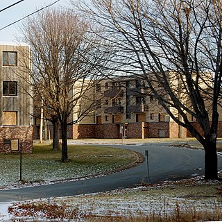
Dartmouth is a built-up community of Halifax Regional Municipality, Nova Scotia, Canada. Located on the eastern shore of Halifax Harbour, Dartmouth has 72,139 residents as of 2021.

<span class="mw-page-title-main">Halifax, Nova Scotia</span> Capital and most populous municipality of Nova Scotia, Canada

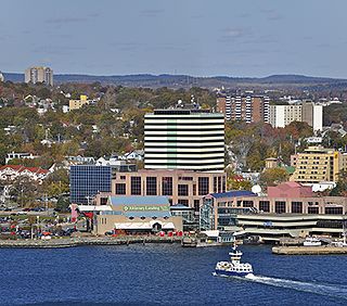
Halifax is the capital and largest municipality of the Canadian province of Nova Scotia, and the largest municipality in Atlantic Canada. As of 2022, it is estimated that the population of the Halifax CMA was 480,582, with 348,634 people in its urban area. The regional municipality consists of four former municipalities that were amalgamated in 1996: Halifax, Dartmouth, Bedford, and Halifax County.

<span class="mw-page-title-main">Bedford Basin</span> Bay in Nova Scotia, Canada

Bedford Basin is a large enclosed bay, forming the northwestern end of Halifax Harbour on Canada's Atlantic coast. It is named in honour of John Russell, 4th Duke of Bedford.

<span class="mw-page-title-main">Bedford, Nova Scotia</span> District of Halifax, Nova Scotia, Canada

Bedford is a former town and now a district of Halifax, Nova Scotia, Canada. It is situated on the north west shore of the Bedford Basin in the central area of the municipality. It borders the neighbouring communities of Hammonds Plains to the west, Sackville to the north, Dartmouth to the east, and Main Land Halifax to the south. Bedford was named in honour of John Russell, 4th Duke of Bedford, Secretary of State for the colonies in 1749.

<span class="mw-page-title-main">A. Murray MacKay Bridge</span> Bridge

The A. Murray MacKay Bridge, known locally as "the new bridge", is a suspension bridge linking the Halifax Peninsula with Dartmouth, Nova Scotia, and opened on July 10, 1970. It is one of two suspension bridges crossing Halifax Harbour. Its counterpart, the Angus L. Macdonald Bridge, was completed in 1955. The bridge carries on average 52,000 vehicle crossings per day, and is part of Nova Scotia Highway 111.

<span class="mw-page-title-main">Lower Sackville, Nova Scotia</span> Community in Nova Scotia, Canada

Lower Sackville is a suburban community of the Halifax Regional Municipality, Nova Scotia, Canada.

<span class="mw-page-title-main">Halifax Harbour</span> Harbour in Nova Scotia, Canada

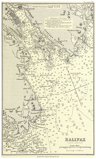
Halifax Harbour is a large natural harbour on the Atlantic coast of Nova Scotia, Canada, located in the Halifax Regional Municipality. Halifax largely owes its existence to the harbour, being one of the largest and deepest ice-free natural harbours in the world. Before Confederation it was one of the most important commercial ports on the Atlantic seaboard. In 1917, it was the site of the world's largest man-made accidental explosion, when the SS Mont-Blanc blew up in the Halifax Explosion of December 6.

<span class="mw-page-title-main">Nova Scotia Highway 107</span> Highway in Nova Scotia

Highway 107 in Nova Scotia runs through the eastern suburbs of the Halifax Regional Municipality, from the Burnside Industrial Park in Dartmouth to an intersection with Trunk 7 in Musquodoboit Harbour. It is 43.2 km (26.8 mi) long, and is mostly two lane, controlled access highway.

<span class="mw-page-title-main">Nova Scotia Highway 118</span> Highway in Nova Scotia

Highway 118 is a divided highway connecting Dartmouth with Highway 102 at Fall River, 14 kilometres (8.7 mi) to the north in the Canadian province of Nova Scotia.

<span class="mw-page-title-main">Halifax Transit</span> Canadian public transport service

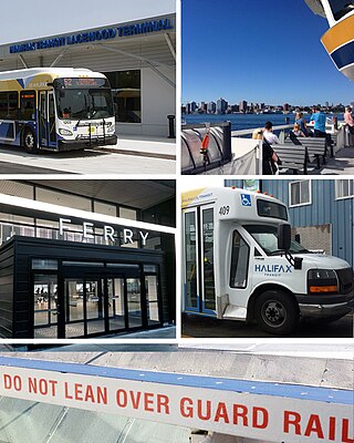
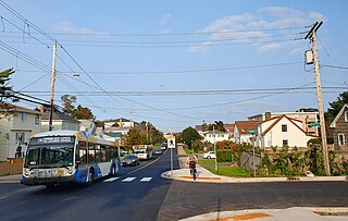
Halifax Transit is a Canadian public transport service operating buses and ferries in Halifax, Nova Scotia. Founded as Metro Transit in March 1981, the agency runs two ferry routes, 66 conventional bus routes, three regional express routes, and three rural routes. Halifax Transit also operates Access-a-Bus, a door-to-door paratransit service for senior and disabled citizens.

Rockingham is a community located within the urban area of the Municipality of Halifax, in Nova Scotia, Canada.

<span class="mw-page-title-main">Eastern Shore (Nova Scotia)</span> Region of Nova Scotia

The Eastern Shore is a region of the Canadian province of Nova Scotia. It is the Atlantic coast running northeast from Halifax Harbour to the eastern end of the peninsula at the Strait of Canso.

Highfield Park is a neighbourhood located in the north end of the community of Dartmouth in Nova Scotia's Halifax Regional Municipality.

<span class="mw-page-title-main">Dartmouth Crossing</span> Urban Neighbourhood in Halifax Regional Municipality, Nova Scotia, Canada

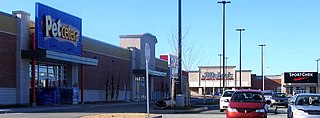
Dartmouth Crossing is a commercial real estate development in Dartmouth, a part of Halifax Regional Municipality, Nova Scotia, Canada.

<span class="mw-page-title-main">Shannon Park, Nova Scotia</span> Neighbourhood in Halifax Regional Municipality, Nova Scotia, Canada

Shannon Park is an urban neighbourhood and former national defence site in the north end of Dartmouth on the eastern shore of Halifax Harbour in the Halifax Regional Municipality (HRM) in Nova Scotia, Canada. It is immediately south of the A. Murray MacKay Bridge in the community of Dartmouth. It straddles Highway 111, a CN Rail freight line, and Halifax Harbour. It is bordered on the south by Tuft's Cove.

<span class="mw-page-title-main">Wallis Heights, Nova Scotia</span> Subdivision in Nova Scotia, Canada

Wallis Heights is a Canadian urban neighbourhood in Nova Scotia's Halifax Regional Municipality.

<span class="mw-page-title-main">Fairview, Nova Scotia</span> Urban Community in Nova Scotia, Canada

Fairview is a community within the urban area of Halifax in Nova Scotia, Canada.

<span class="mw-page-title-main">Transportation in Halifax, Nova Scotia</span>

Halifax Regional Municipality has a multi-modal transportation network.

The Halifax Regional Municipality (HRM) is a major generator of economic activity in Atlantic Canada.

<span class="mw-page-title-main">Amalgamation of the Halifax Regional Municipality</span>

The amalgamation of four municipalities on April 1, 1996, was the creation of the Halifax Regional Municipality, Nova Scotia, Canada. It resulted in the regional municipality's current boundaries.

References

  1. "Burnside". Geographical Names Data Base . Natural Resources Canada.
  2. "Business Parks; Burnside Industrial Park". halifax.ca. Government of the Municipality of Halifax. Retrieved 12 March 2020.
  3. Chapman, Harry (2001). In the wake of the Alderney : Dartmouth, Nova Scotia, 1750-2000. Dartmouth Historical Association (2nd ed.). [Dartmouth, N.S.]: Dartmouth Historical Association. pp. 379–380. ISBN   1-55109-374-X. OCLC   48398897.
  4. Kempster, Norman (11 December 1969). "A new industrial park, but some old problems". The 4th Estate. p. 7.
  5. Hollingsworth, Al (14 July 1976). "North Dartmouth Industrial Complex One Of The Best". Dartmouth Free Press. p. 2, second section.
  6. "Business Parks; Burnside Industrial Park". halifax.ca. Government of the Municipality of Halifax. Retrieved 12 March 2020.
  7. Atlantic Canada Opportunities Agency (February 25, 1999). Government of Canada assisting major expansion at Swedwood Canada. Retrieved on: May 4, 2008.
  8. Nova Scotia Business Inc. (July 9, 2004). News Release Archived 2009-09-04 at the Wayback Machine . Retrieved on: May 4, 2008.