
The 1990 Luzon earthquake struck the island of Luzon in the Philippines at 4:26 p.m. on July 16 (PDT) or 3:26 p.m. (PST) with an estimated moment magnitude of 7.7 and a maximum Mercalli intensity of IX (Violent) and produced a 125 km-long ground rupture that stretched from Dingalan, Aurora to Kayapa, Nueva Vizcaya. The event was a result of strike-slip movements along the Philippine Fault and the Digdig Fault within the Philippine Fault System. The earthquake's epicenter was near the town of Rizal, Nueva Ecija, northeast of Cabanatuan City. An estimated 1,621 people were killed, most of the fatalities located in Central Luzon and the Cordillera region.

The 1968 Casiguran earthquake occurred on with a moment magnitude of 7.6 and a maximum Mercalli intensity of IX (Violent). The thrust earthquake's epicenter was in Casiguran, Quezon. A small non-destructive tsunami was generated and at least 207 people were killed. The majority of the deaths occurred in the collapse of a six-story building in Manila.

The September 2007 Sumatra earthquakes were a series of megathrust earthquakes that struck the Sunda Trench off the coast of Sumatra, Indonesia, with three of magnitude 7 or greater. A series of tsunami bulletins was issued for the area. The most powerful of the series had a magnitude of 8.4, which makes it in the top 20 of the largest earthquakes ever recorded on a seismograph.
The 2010 Central Canada earthquake occurred with a moment magnitude of 5.0 in Central Canada on 23 June at about 13:41:41 EDT and lasted about 30 seconds. The epicentre was situated in the area of Buckingham, Quebec, approximately 56 kilometres (35 mi) north of Ottawa, Ontario, closest to the settlement of Val-des-Bois, Quebec. Canada's capital, Ottawa, declared this earthquake as being its most powerful in 65 years.

The Santa Monica Parish Church, commonly known as the Sarrat Church, is a Roman Catholic parish church in Barangay San Leandro, Poblacion, Sarrat, Ilocos Norte, Philippines. It was built in 1779 and was originally known as San Miguel Church. The Santa Monica Church complex includes the convent connected to the church by an elevated three-level brick stairway.

The Sagaing Fault is a major fault in Burma, a mainly continental right-lateral transform fault between the Indian Plate and Sunda Plate. It links the divergent boundary in the Andaman Sea with the zone of active continental collision along the Himalayan front. It passes through populated cities of Mandalay, Yamethin, Pyinmana, the capital Naypyidaw, Toungoo and Pegu before dropping off into the Gulf of Martaban, running for a total length of over 1200 kilometers.
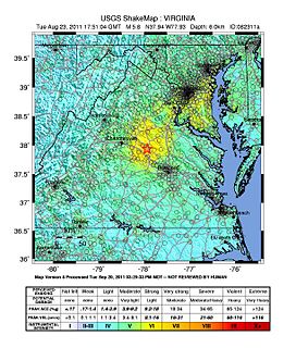
On August 23, 2011, a magnitude 5.8 earthquake hit the Piedmont region of the U.S. state of Virginia at 1:51:04 p.m. EDT. The epicenter, in Louisa County, was 38 mi (61 km) northwest of Richmond and 5 mi (8 km) south-southwest of the town of Mineral. It was an intraplate earthquake with a maximum perceived intensity of VIII (Severe) on the Mercalli intensity scale. Several aftershocks, ranging up to 4.5 in magnitude, occurred after the main tremor.

The 2011 Oklahoma earthquake was a 5.7 magnitude intraplate earthquake which occurred near Prague, Oklahoma on November 5 at 10:53 p.m. CDT in the U.S. state of Oklahoma. The epicenter of the earthquake was in the vicinity of several active wastewater injection wells. According to the United States Geological Survey (USGS), it was the most powerful earthquake ever recorded in Oklahoma; this record was surpassed by the 2016 Oklahoma earthquake. The previous record was a 5.5 magnitude earthquake that struck near the town of El Reno in 1952. The quake's epicenter was approximately 44 miles (71 km) east-northeast of Oklahoma City, near the town of Sparks and was felt in the neighboring states of Texas, Arkansas, Kansas and Missouri and even as far away as Tennessee and Wisconsin. The quake followed several minor quakes earlier in the day, including a 4.7 magnitude foreshock. The quake had a maximum perceived intensity of VIII (Severe) on the Mercalli intensity scale in the area closest to the epicenter. Numerous aftershocks were detected after the main quake, with a few registering at 4.0 magnitude.
The 2017 Surigao earthquake occurred on February 10, 2017 at 10:03 PM (PST), with a surface wave magnitude of 6.7 off the coast of Surigao del Norte in the Philippines. According to the PHIVOLCS Earthquake Intensity Scale the earthquake was an Intensity VII (Destructive) earthquake at maximum. In the past Surigao province has been hit by a magnitude 7.2 tremor in both 1879 and 1893.

The 2017 Batangas earthquakes were an earthquake swarm that occurred from early April to mid-August 2017, affecting the province of Batangas in the Philippines and other nearby areas.
On April 22, 2019, a 6.1 magnitude earthquake struck the island of Luzon in the Philippines, leaving at least 18 dead, three missing and injuring at least 256 others. Despite the fact that the epicenter was in Zambales, most of the damage to infrastructure occurred in the neighboring province of Pampanga, which suffered damage to 29 buildings and structures.
On December 12, 1999, a 7.3 earthquake struck the northern coast of Zambales in the Philippines. It was felt in various provinces on the island of Luzon including as far north as Ilocos Norte and as far south as Quezon. This is the second earthquake with a magnitude of 7 to hit the area in 10 years with a 7.7 earthquake having occurred in 1990 which killed more than 2,000 people.
On 27 November 1461, a powerful earthquake and series of aftershocks struck Italy's Abruzzo region along the Aterno River. The tremors caused widespread damage to Abruzzo's capital, L'Aquila, and the surrounding villages. At least 80 people are recorded to have died and numerous people were injured by the earthquakes. The quakes also caused major, permanent damage to religious sites and changed politics for L'Aquila and the Abruzzo region.
The 2019 Cotabato earthquakes were an earthquake swarm which struck the province of Cotabato on the island of Mindanao in the Philippines in October 2019. Three of these earthquakes were above 6.0 on the moment magnitude scale with a Mercalli intensity of VIII. More than 40 people have been reported dead or missing and nearly 800 were injured as a result of these events.
A 6.6 magnitude earthquake struck the island province of Masbate in the Philippines on August 18, 2020, leaving at least 2 dead and 170 injured.
The 1973 Ragay Gulf earthquake occurred at around 16:30 local time. It was measured as magnitude 7.0 on the surface wave magnitude scale. It had a maximum intensity of IX (Violent) on the MMI, according to the National Geophysics Data Center, while according to the Philippine Institute of Volcanology and Seismology, the tremor had an intensity of VIII on the PHIVOLCS Earthquake Intensity Scale. It killed 14 people, injured 100 others, and caused an estimated $2 million in damages.
On July 27, 2022, at 08:43:24 a.m. (PHT), an earthquake struck the island of Luzon in the Philippines. The United States Geological Survey (USGS) reported the earthquake as having a magnitude of 7.0 Mw . At least four people died and 131 were injured.

