2017 Leyte earthquake

Last updated

2017 Leyte earthquake
Philippines relief location map (square).svg
Bullseye1.png
UTC  time2017-07-06 08:03:57
ISC  event 611600353
USGS-ANSS ComCat
Local dateJuly 6, 2017 (2017-07-06)
Local time16:03:53 PST
Magnitude6.5 Ms
Depth2 km (1 mi)
Epicenter 11°07′N124°41′E / 11.11°N 124.69°E / 11.11; 124.69
Fault Philippine Fault - Leyte Segment
Type Tectonic
Areas affected
Total damage₱271 million
Max. intensity VIII (Severe)
PEIS – VII (Destructive) [1]
TsunamiNo
LandslidesYes
Aftershocks796+ (as of July 11, including the M5.4 aftershock)
Casualties4 dead, [2] 100+ injured

On July 6, 2017, a 6.5 magnitude earthquake hit Leyte, causing at least 4 deaths and 100 injuries. The quake also caused power interruptions in the whole of Eastern Visayas and nearby Bohol.

Contents

The Philippine archipelago is located in the Pacific Ring of Fire, where earthquakes and volcanic activity are common.

Earthquake

The 6.5 magnitude earthquake was recorded by the Philippine Institute of Volcanology and Seismology (PHIVOLCS) to have occurred at 4:03:53 p.m. (16:03:53 UTC+8) and determined it to be of tectonic origin. PHIVOLCS recorded the depth of focus at 2 kilometers (1.2 mi) [3] and its epicenter 8 kilometers (5.0 mi) south of Jaro. [4]

Intensity

Scale

Location
VII Ormoc City and Kananga, Leyte
VI Jaro and Capoocan, Leyte
V Palo, Leyte; Tacloban City; Cebu City; Mandaue City
IV Catbalogan; Cabucgayan and Naval, Biliran; Tolosa and Bato, Leyte Hinunangan, Southern Leyte; Sagay City, Negros Occidental; Burgos, Surigao del Norte; Biliran, Leyte
III Bogo and Talisay, Cebu; Roxas City; Iloilo City; Bacolod City; Inopacan and Baybay, Leyte; Sogod, Southern Leyte; Calatrava, Negros Occidental; Tagbilaran City; Jagna, Bohol; Borongan, Eastern Samar; Guihulngan City and Tayasan, Negros Oriental; Cadiz City and Toboso, Escalante, Negros Occidental
II Libjo, San Jose, Cagdianao, Dinagat Islands; Sorsogon City; Lapu-lapu City; San Juan, Southern Leyte; Javier, Leyte; Tanjay City and Sibulan, Negros Oriental; Sorsogon City; Dumaguete
I La Carlota City, Negros Occidental; Catarman, Northern Samar

The United States Geological Survey (USGC) recorded the depth of focus for the earthquake at 6.5 kilometers (4.0 mi), [5] deeper than what is recorded by PHIVOLCS.

The tremor was caused by the movement of the Leyte Segment of the Philippine Fault. A ground rupture was recorded in Barangay Tongonan in Ormoc which was described by the Department of Science and Technology as the epicenter area of the quake. As of July 9, PHIVOLCS was still assessing the extent of the rupture which could span 20 kilometers (12 mi) across the area. [6]

No tsunami warning was raised by the Pacific Tsunami Warning Center. [7]

Damage

The Department of Public Works and Highways Leyte Fourth Engineering District announced on July 10, 2017 that they estimate that at least ₱271 million of damage was caused by the earthquake. The local agency said that the city of Ormoc, and nearby town Kananga sustained the heaviest damage. [8]

The earthquake caused a building in Kananga to collapse, killing one person. Another person died in the town when a house collapsed in Ormoc. [4] Another person was killed in a landslide in Ormoc while another body was found in the same city. [2]

Authorities temporarily closed Ormoc Airport after its runway was damaged. [9]

Ten schools located in the towns of Kananga, Jaro, Barugo, and San Isidro were destroyed by the earthquake while ten more schools located in Inopacan, Albuera, Mérida, Barugo, and San Miguel were partially damaged. [10]

Leyte, Samar and Bohol experienced power blackouts while power supplies in Panay, Cebu, and Negros were also reportedly affected. [11]

Aftermath

PHIVOLCS recorded 796 aftershocks as of July 11, 2017. [12] Ormoc and Kananga declared a state of calamity. [13] [14]

Residents in barangays Lake Danao and Tongonan in Ormoc were ordered to evacuate due to those localities being situated directly on the path of the Philippine Fault line. [10]

On August 23, 2017, an aftershock of magnitude 5.1 occurred. [15] This aftershock damaged 56 structures in Ormoc. Two people died, one after suffering a head injury after falling and another from a heart attack. [16]

See also

Related Research Articles

<span class="mw-page-title-main">1990 Luzon earthquake</span> Earthquake in the Philippines

The 1990 Luzon earthquake occurred on July 16 at 4:26 p.m. (PDT) or 3:26 p.m. (PST) on the densely populated island of Luzon in the Philippines. The shock had a surface wave magnitude of 7.8 and produced a 125 km-long ground rupture that stretched from Dingalan, Aurora to Kayapa, Nueva Vizcaya. The event was a result of strike-slip movements along the Philippine Fault and the Digdig Fault within the Philippine Fault System. The earthquake's epicenter was near the town of Rizal, Nueva Ecija, northeast of Cabanatuan. An estimated 1,621 people were killed, most of the fatalities located in Central Luzon and the Cordillera region.

<span class="mw-page-title-main">1976 Moro Gulf earthquake</span> Earthquake in the Philippines

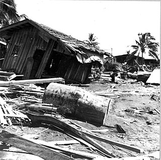
The 1976 Moro Gulf earthquake and tsunami occurred on August 17, 1976, at 00:11 local time near the islands of Mindanao and Sulu, in the Philippines. It measured 8.0 on the moment magnitude scale occurring at a depth of 20 km (12 mi). The earthquake was accompanied by a destructive tsunami that resulted in a majority of the estimated 5,000 to 8,000 fatalities. It was the deadliest and strongest earthquake in the Philippines in 58 years since the 1918 Celebes Sea earthquake.

<span class="mw-page-title-main">Marikina Valley Fault System</span> Fault along Metro Manila and surrounding areas

The Marikina Valley Fault System, also known as the Valley Fault System (VFS), is a dominantly right-lateral strike-slip fault system in Luzon, Philippines. It extends from Doña Remedios Trinidad, Bulacan in the north and runs through the provinces of Rizal, and the Metro Manila cities of Quezon, Marikina, Pasig, Taguig and Muntinlupa, and the provinces of Cavite and Laguna that ends in Canlubang.

The 2012 Negros earthquake occurred on February 6 at 11:49 PST, with a body wave magnitude of 6.7 and a maximum intensity of VII (Destructive) off the coast of Negros Oriental, Philippines. The epicenter of the thrust fault earthquake was approximately 72 kilometres (45 mi) north of Negros Oriental's provincial capital, Dumaguete.

<span class="mw-page-title-main">2013 Bohol earthquake</span> Magnitude 7.2 earthquake in Bohol

The 2013 Bohol earthquake occurred on October 15 at 8:12:31 PST in Bohol, an island province located in Central Visayas, Philippines. The magnitude of the earthquake was recorded at Mw 7.2, with epicenter 6 kilometres (3.7 mi) S 24° W of Sagbayan, and its depth of focus was 12 kilometres (7.5 mi). It affected the whole Central Visayas region, particularly Bohol and Cebu. The earthquake was felt in the whole Visayas area and as far as Masbate island in the north and Cotabato provinces in southern Mindanao.

<span class="mw-page-title-main">Bohol Fault System</span>

Bohol Fault System is a reverse fault system in Bohol province, Philippines. This fault system contains 3 segments: the newly found North Bohol Fault following the 2013 Bohol earthquake, the South Offshore Fault, and the East Bohol Fault.

The 2017 Surigao earthquake occurred on February 10, 2017, at 10:03 PM (PST), with a surface wave magnitude of 6.7 off the coast of Surigao del Norte in the Philippines. According to the PHIVOLCS Earthquake Intensity Scale the earthquake was an Intensity VII (Destructive) earthquake at maximum. In the past Surigao province has been hit by a magnitude 7.2 tremor in both 1879 and 1893.

<span class="mw-page-title-main">2017 Batangas earthquakes</span> Earthquakes in the Philippines

The 2017 Batangas earthquakes were an earthquake swarm that occurred from early April to mid-August 2017, affecting the province of Batangas in the Philippines and other nearby areas.

On April 22, 2019, a 6.1 magnitude earthquake struck the island of Luzon in the Philippines, leaving at least 18 dead, three missing and injuring at least 256 others. Despite the fact that the epicenter was in Zambales, most of the damage to infrastructure occurred in the neighboring province of Pampanga, which suffered damage to 29 buildings and structures.

<span class="mw-page-title-main">2019 Batanes earthquake</span> Natural disaster

The 2019 Batanes earthquake was a magnitude 6.0 earthquake which struck Batanes, Philippines on July 27, 2019. It was preceded by a 5.4 magnitude foreshock. Nine people were killed by the combined effects of the earthquakes.

The 2019 Cotabato earthquakes were an earthquake swarm which struck the province of Cotabato on the island of Mindanao in the Philippines in October 2019. Three of these earthquakes were above 6.0 on the moment magnitude scale with a Mercalli intensity of VIII. More than 40 people have been reported dead or missing and nearly 800 were injured as a result of these events.

At 14:11 PST on December 15, 2019, the province of Davao del Sur on the island of Mindanao in the Philippines was struck by an earthquake measuring 6.8 Mww. It had a maximum perceived intensity of VII on the Modified Mercalli Intensity Scale. At least 13 people were killed and another 210 injured.

<span class="mw-page-title-main">2020 Masbate earthquake</span> 2020 earthquake in the Philippines

A 6.6 magnitude earthquake struck the island province of Masbate in the Philippines on August 18, 2020, leaving at least 2 dead and 170 injured.

<span class="mw-page-title-main">1990 Panay earthquake</span> Earthquake in Panay Island on June 14, 1990

The 1990 Panay earthquake occurred at 3:41 p.m. local time on 14 June 1990 with a moment magnitude of 7.1 in the Richter scale, leaving eight dead and 41 others injured. The epicenter was located at Culasi, Antique on Panay Island in the Philippines. The depth was computed to be 15 kilometers. It was generated by fault movement in the collisional zone off western Panay Island.

The 1990 Bohol earthquake occurred on February 8, 1990 at 15:15:32 which had a magnitude of 6.8 Mw . The earthquake had a moderate depth of 25.9 km (16 mi). Most of the damage was observed in the province of Bohol. A tsunami hit the southeastern coastline of Bohol and the island of Camiguin. There were 6 deaths, over 200 injuries and an estimated ₱157 million in total damage reported.

On 9 July 2019, at 8:36 PM (PST), an earthquake measuring Mw 5.6 jolted the province of North Cotabato, Davao del Sur, and other nearby provinces. The National Disaster Risk Reduction and Management Council reported one dead and three injured in Makilala after the earthquake, and a total of 164 families affected in Cotabato Province. Near the epicenter of the earthquake, the severity of strong ground motion was assigned VI (Strong) on the Modified Mercalli intensity scale. A total of 106 schools, 119 houses, and 14 other infrastructures were damaged by the earthquake.

On February 7, 2021, at 12:22 PM PST, an earthquake measuring Mww  6.0 struck Davao del Sur and Cotabato. The event registered a Modified Mercalli Intensity Scale (MMI) of VIII (Severe) with VII on the PHIVOLCS Earthquake Intensity Scale (PEIS).

On August 12, 2021, at 01:46:12 PST, a strong Mw  7.1 earthquake struck the island of Mindanao at a depth of 55.1 kilometers (34.2 mi). It had a maximum perceived Intensity V on the PHIVOLCS Earthquake Intensity Scale. No damage or injuries were reported but a young man was killed by the earthquake.

<span class="mw-page-title-main">2022 Luzon earthquake</span> Earthquake in the Philippines

On July 27, 2022, at 8:43:24 a.m. (PHT), an earthquake struck the island of Luzon in the Philippines. The earthquake had a magnitude of 7.0 Mw , with an epicenter in Abra province. Eleven people were reported dead and 615 were injured. At least 35,798 homes, schools and other buildings were damaged or destroyed, resulting in ₱1.88 billion (US$34 million) worth of damage.

References

  1. Philippine Institute of Volcanology and Seismology (2018). "PHIVOLCS Earthquake Intensity Scale (PEIS)" . Retrieved November 13, 2019.
  2. 1 2 Dacanay, Barbara Mae (July 8, 2017). "Four dead, 100 injured in Leyte's 6.5 magnitude quake". GulfNews. Retrieved July 9, 2017.
  3. "PHIVOLCS Earthquake Information No.:5". PHIVOLCS. July 6, 2017. Retrieved July 11, 2017.
  4. 1 2 "WATCH, LOOK | At least 2 dead in Magnitude 6.5 Leyte quake". InterAksyon. News5. July 8, 2017.
  5. "M 6.5 - 3km NNE of Masarayao, Philippines". United States Geological Survey. July 6, 2017. Retrieved July 16, 2017.
  6. Tupaz, Voltaire (July 9, 2017). "Phivolcs finds ground rupture in quake-hit Leyte". Rappler. Retrieved July 11, 2017.
  7. "6.5-magnitude quake hits central Philippine island: USGS (Update)". Phys.org. Science X network. July 6, 2017. Retrieved July 16, 2017.
  8. Abrematea, Nestor (July 11, 2017). "Quake damage reaches P271 M". Manila Bulletin. Retrieved July 11, 2017.
  9. "Panic, damage after deadly Leyte earthquake". Philippine Daily Inquirer. July 7, 2017.
  10. 1 2 "20 schools in Leyte damaged by earthquake; 2 barangays along fault line set for full evacuation". BusinessWorld. BusinessWorld Publishing Corporation. July 13, 2017. Retrieved July 13, 2017.
  11. Saulon, Victor (July 13, 2017). "Earthquake-affected islands facing longer power blackout". BusinessWorld. Retrieved July 13, 2017.
  12. Saulon, Victor; Caro, Jil Danielle (July 12, 2017). "Power expected to be back in parts of Leyte, Bohol today". BusinessWorld. Retrieved July 12, 2017.
  13. "Quake-hit Ormoc under state of calamity". Coconuts Manila. ABS-CBN News. July 11, 2017. Retrieved July 11, 2017.
  14. "Proclamation No. 283, s. 2017 | GOVPH". Official Gazette of the Republic of the Philippines. Retrieved July 21, 2022.
  15. "BULUSAN VOLCANO BULLETIN 23 January 2018 08:00 A.M".
  16. "2 dead as shallow earthquake hits Leyte".