2017 Batangas earthquakes

Last updated

2017 Batangas earthquakes
2017 Southern Luzon earthquakes
2017-04-12 13-58-56 Basilica of the Immaculate Conception Batangas City after April 2017 earthquake.jpeg
The partially damaged Basilica of the Immaculate Conception in Batangas City after the earthquake
UTC  time2017-04-08 07:09:23
ISC  event 610639847
USGS-ANSS ComCat
Local dateApril 8, 2017 (2017-04-08)
Local time15:09:21 PST
Magnitude6.0 Ms [note 1]
Depth8 km (5 mi)
TypeTectonic
Areas affected Calabarzon, Mimaropa, Metro Manila
Total damage₱18 million (April 4 earthquake)
Max. intensity
TsunamiNo
Aftershocks2,390
Casualties6 injured

The 2017 Batangas earthquakes were an earthquake swarm [2] that occurred from early April to mid-August 2017, affecting the province of Batangas in the Philippines and other nearby areas.

Contents

The first major earthquake occurred on April 4 at 8:58 pm Philippine Standard Time, with a surface wave magnitude of 5.5 off the coast of Batangas. According to the PHIVOLCS Earthquake Intensity Scale, the earthquake had an intensity of VII (Very Strong). [3]

On April 8, stronger earthquakes occurred in the province. The PHIVOLCS recorded the strongest earthquake later that afternoon that had a surface wave magnitude of 6.0. [1] Another earthquake struck on August 11, with a surface wave magnitude of 6.3.

Three years later, Taal Volcano, about 25 kilometers from the epicenter, erupted after 43 years of inactivity.

Earthquakes

April 4 earthquake

The quake was recorded by PHIVOLCS on April 4, 2017 at 8:58 PM (UTC+8). Based on that record, the epicenter of the 5.5 earthquake was located 7 kilometers northwest of Tingloy, Batangas. The earthquake was of tectonic origin. Metro Manila and nearby provinces felt shaking at Intensity 3 while Obando, Bulacan felt Intensity 4, and Batangas City experienced Intensity 6 shaking. [4] [5] The earthquake is suspected to be the caused by the movement of the Lubang Fault. [6] At 1:00 pm on April 7, PHIVOLCS stated that they have recorded 934 aftershocks; 118 of which were plotted and while 14 were reportedly felt. [7]

The Pacific Tsunami Warning Center announced no tsunami warning following the earthquake.[ citation needed ]

April 8 earthquakes

Two earthquakes occurred near the towns of Mabini and Tanauan on April 8. PHIVOLCS recorded the first earthquake which occurred near Mabini at 3:07 pm as having a surface wave magnitude of 5.6 while the second earthquake which happened in Talaga Proper, Mabini, Batangas, at 3:09 pm was recorded as having a surface wave magnitude of 6.0. The United States Geological Survey (USGS) recorded the first as a magnitude 5.7 earthquake while the second as a moment magnitude of 5.9 earthquake. [8] [1]

August 11 earthquake

PHIVOLCS recorded the earthquake which occurred at 1:28 pm as having a surface wave magnitude of 6.3. The United States Geological Survey (USGS) recorded the earthquake as a moment magnitude of 6.2 earthquake.

Shocks

Shakemap of the strongest earthquake on April 8, 2017 which was prepared by the USGS. Shakemap Earthquake 8 April 2017 Mindoro Philippines.jpg
Shakemap of the strongest earthquake on April 8, 2017 which was prepared by the USGS.

Earthquakes with at least magnitude 5 as recorded by PHIVOLCS:

Date / time
(PST)
Magnitude Type Depth
Hypocenter
Epicenter Ref.
Location Latitude Longitude
April 4, 2017   20:58:455.5 Ms 7 km (4.3 mi) Tingloy 13.68°N120.93°E Report
April 8, 2017   15:07:555.6 Ms 27 km (17 mi) Mabini 13.75°N120.93°E Report
April 8, 2017   15:09:216.0 Ms 8 km (5.0 mi) Mabini 13.70°N120.93°E Report
August 11, 2017   13:28:006.3 Ms 177 km (110 mi) Nasugbu 13.95°N120.52°E Report

Impact

Damages on some buildings, resorts and houses have been reported. The Basilica of Saint Martin of Tours or Taal Basilica, which is considered to be the largest Roman Catholic Church in Asia and located in Taal, Batangas, sustained damage during the April 4 earthquake. The April 8 earthquakes caused concrete blocks to fall from the church facade. [9] The Basilica of the Immaculate Conception Church in Batangas City also sustained damage on its walls during the April 8 quake. [10]

The Batangas Provincial capitol also sustained damaged from the April 4 earthquake. The initial estimated cost of damage to the building was ₱18 million. On April 5, the Batangas provincial government declared a state of calamity. [11]

Six people were injured by the 8 April quake. Around 14,000 people were temporarily relocated in evacuation centers. [12]

During his installation on April 21, 2017, Lipa Archbishop Gilbert Garcera ordered Father Aurelio Oscar Dimaapi to temporarily close the Minor Basilica of the Immaculate Conception in order to prevent injuries.

In the aftermath of the August 11 tremor, many students were disturbed since the tremor struck during class hours. Several schools suspended classes after the earthquake. So far, no damage has been reported.

Power

The earthquake also damaged several power plants supplying the Luzon Grid, like one generator unit of the Ilijan Power Plant, one unit of Avion Power Plant, all units of Santa Rita Combined Cycle Power Plant, and one unit of San Lorenzo Combined Cycle Power Plant, resulting to a loss of 2,584 MW. The switchyard of San Lorenzo Power Plant was damaged and a transmission tower was toppled also by the earthquakes. As a result, the power supply reserve for Luzon decreased, leading the National Grid Corporation of the Philippines to place the Luzon Grid on "yellow" alert on April 10 and 11, and the Department of Energy ordered immediate repair of power plants damaged. [13] [14] A policy to protect the grid from earthquake damage is being drafted by the Department of Energy after the quakes. [15]

See also

Related Research Articles

<span class="mw-page-title-main">Taal Volcano</span> Volcano in the Philippines

Taal Volcano is a large caldera filled by Taal Lake in the Philippines. Located in the province of Batangas about 50 kilometers (31 mi) south of Manila, the volcano is the second most active volcano in the country with 38 recorded historical eruptions, all of which were concentrated on Volcano Island, near the middle of Taal Lake. The caldera was formed by prehistoric eruptions between 140,000 and 5,380 BP.

<span class="mw-page-title-main">1990 Luzon earthquake</span> Earthquake in the Philippines

The 1990 Luzon earthquake struck the island of Luzon in the Philippines at 4:26 p.m. on July 16 (PDT) or 3:26 p.m. (PST) with an estimated moment magnitude of 7.7 and a maximum Mercalli intensity of IX (Violent) and produced a 125 km-long ground rupture that stretched from Dingalan, Aurora to Kayapa, Nueva Vizcaya. The event was a result of strike-slip movements along the Philippine Fault and the Digdig Fault within the Philippine Fault System. The earthquake's epicenter was near the town of Rizal, Nueva Ecija, northeast of Cabanatuan. An estimated 1,621 people were killed, most of the fatalities located in Central Luzon and the Cordillera region.

<span class="mw-page-title-main">Taal Basilica</span> Roman Catholic church in Batangas, Philippines

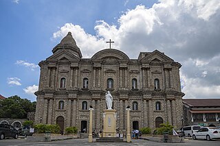
The Minor Basilica of Saint Martin of Tours, also known as the Taal Basilica, is a minor basilica in the town of Taal, Batangas, within the Archdiocese of Lipa. It is considered to be the largest church in the Philippines and in Asia, standing 88.6 meters (291 ft) long and 48 meters (157 ft) wide. Martin of Tours is the patron saint of Taal, whose feast is celebrated every November 11.

The 2012 Negros earthquake occurred on February 6 at 11:49 PST, with a body wave magnitude of 6.7 and a maximum intensity of VII (Destructive) off the coast of Negros Oriental, Philippines. The epicenter of the thrust fault earthquake was approximately 72 kilometres (45 mi) north of Negros Oriental's provincial capital, Dumaguete.

On August 17, 1983, at 20:17 PST (UTC+08:00), an earthquake struck the island of Luzon in the Philippines. The shock had a surface wave magnitude of 6.5 and a maximum Mercalli intensity of VIII (Severe), killing 16 people and injuring 47. Seven towns were damaged, several buildings collapsed, and electricity was cut off in Laoag. Features like sand volcanoes and cracks formed during the quake.

<span class="mw-page-title-main">2013 Bohol earthquake</span> Magnitude 7.2 earthquake in Bohol

The 2013 Bohol earthquake occurred on October 15 at 8:12:31 PST in Bohol, an island province located in Central Visayas, Philippines. The magnitude of the earthquake was recorded at Mw 7.2, with epicenter 6 kilometres (3.7 mi) S 24° W of Sagbayan, and its depth of focus was 12 kilometres (7.5 mi). It affected the whole Central Visayas region, particularly Bohol and Cebu. The earthquake was felt in the whole Visayas area and as far as Masbate island in the north and Cotabato provinces in southern Mindanao.

The 2017 Surigao earthquake occurred on February 10, 2017, at 10:03 PM (PST), with a surface wave magnitude of 6.7 off the coast of Surigao del Norte in the Philippines. According to the PHIVOLCS Earthquake Intensity Scale the earthquake was an Intensity VII (Destructive) earthquake at maximum. In the past Surigao province has been hit by a magnitude 7.2 tremor in both 1879 and 1893.

On July 6, 2017, a 6.5 magnitude earthquake hit Leyte, causing at least 4 deaths and 100 injuries. The quake also caused power interruptions in the whole of Eastern Visayas and nearby Bohol.

On April 22, 2019, a 6.1 magnitude earthquake struck the island of Luzon in the Philippines, leaving at least 18 dead, three missing and injuring at least 256 others. Despite the fact that the epicenter was in Zambales, most of the damage to infrastructure occurred in the neighboring province of Pampanga, which suffered damage to 29 buildings and structures.

The 2019 Eastern Samar Earthquake struck the islands of Visayas in the Philippines on April 23, 2019 at 1:37:51 PM(PHT).It had a moment magnitude of 6.5(Mww6.4 by USGS) and a local magnitude of 6.2 with a max intensity of VI based on the PHIVOLCS Earthquake Intensity Scale(PEIS). The epicenter was in San Julian, Eastern Samar and the hypocenter was at a depth of 64 km(~39.76 mi). As of April 30, 2019 there were 172 aftershocks ranging from magnitudes of 1.6 to 4.6. The earthquake injured 48 people and damaged about 245 homes.

On December 12, 1999, a Mw7.3 earthquake struck the northern coast of Zambales in the Philippines. It was felt in various provinces on the island of Luzon including as far north as Ilocos Norte and as far south as Quezon. This is the second earthquake with a magnitude of 7 to hit the area in 10 years with a Mw7.7 earthquake having occurred in 1990 which killed more than 2,000 people.

<span class="mw-page-title-main">2019 Batanes earthquake</span> Natural disaster

The 2019 Batanes earthquake was a magnitude 6.0 earthquake which struck Batanes, Philippines on July 27, 2019. It was preceded by a 5.4 magnitude foreshock. Nine people were killed by the combined effects of the earthquakes.

The 2019 Cotabato earthquakes were an earthquake swarm which struck the province of Cotabato on the island of Mindanao in the Philippines in October 2019. Three of these earthquakes were above 6.0 on the moment magnitude scale with a Mercalli intensity of VIII. More than 40 people have been reported dead or missing and nearly 800 were injured as a result of these events.

<span class="mw-page-title-main">2020–2022 Taal Volcano eruptions</span> Volcanic eruption in the Philippines

Taal Volcano in Batangas, Philippines began to erupt on January 12, 2020, when a phreatomagmatic eruption from its main crater spewed ashes over Calabarzon, Metro Manila, and some parts of Central Luzon and Ilocos Region, resulting in the suspension of school classes, work schedules, and flights in the area. The Philippine Institute of Volcanology and Seismology (PHIVOLCS) subsequently issued an Alert Level 4, indicating "that a hazardous explosive eruption is possible within hours to days." Volcanic activity continued into 2021, when smaller eruptions occurred in July 2021. On 26 March 2022, a short-lived phreatomagmatic eruption was recorded by PHIVOLCS raising the status from Alert level 2 to Alert level 3 as well as surrounding towns.

The 1990 Bohol earthquake occurred on February 8, 1990 at 15:15:32 which had a magnitude of 6.8 Mw . The earthquake had a moderate depth of 25.9 km (16 mi). Most of the damage was observed in the province of Bohol. A tsunami hit the southeastern coastline of Bohol and the island of Camiguin. There were 6 deaths, over 200 injuries and an estimated ₱157 million in total damage reported.

On February 7, 2021, at 12:22 PM PST, an earthquake measuring Mw  6.0 struck Davao del Sur and Cotabato. The event registered a Modified Mercalli Intensity Scale (MMI) of VIII (Severe) with VII on the PHIVOLCS Earthquake Intensity Scale (PEIS).

On August 12, 2021, at 01:46:12 PST, a strong Mw  7.1 earthquake struck the island of Mindanao at a depth of 55.1 kilometers (34.2 mi). It perceived Intensity V on the PHIVOLCS Earthquake Intensity Scale. No damage or injuries were reported but a young man was killed by the earthquake.

<span class="mw-page-title-main">2022 Luzon earthquake</span> Earthquake in the Philippines

On July 27, 2022, at 8:43:24 a.m. (PHT), an earthquake struck the island of Luzon in the Philippines. The earthquake had a magnitude of 7.0 Mw , with an epicenter in Abra province. Eleven people were reported dead and 615 were injured. At least 35,798 homes, schools and other buildings were damaged or destroyed, resulting in ₱1.88 billion (US$34 million) worth of damage.

<span class="mw-page-title-main">December 2023 Mindanao earthquake</span> Magnitude 7.6 earthquake in the Philippines

On December 2, 2023, at 22:37 PST, a magnitude 7.4-7.6 earthquake occurred off the island of Mindanao in the Philippines. The shallow subduction earthquake killed at least three people and left 79 injured.

References

  1. 1 2 3 "Earthquakes hit Batangas, felt in other areas in Luzon". CNN Philippines. April 8, 2017. Archived from the original on April 9, 2017. Retrieved April 8, 2017.
  2. "Series of quakes 'normal', says PHIVOLCS chief". ABS-CBN News. April 8, 2017. Retrieved April 8, 2017.
  3. Ellalyn De Vera-Ruiz (April 5, 2017). "5.5 magnitude earthquake hits Batangas". Manila Bulletin. Archived from the original on April 8, 2017. Retrieved April 9, 2017.
  4. Jaymee T. Gamil. "503 aftershocks recorded after Batangas quake". Philippine Daily Inquirer. Retrieved April 9, 2017.
  5. "Magnitude 5.5 earthquake hits Batangas". CNN Philippines. April 5, 2017. Archived from the original on April 6, 2017. Retrieved April 9, 2017.
  6. "Magnitude 5.5 quake rocks Batangas". ABS-CBN News. April 4, 2017. Retrieved April 8, 2017.
  7. Flores, Helen (April 8, 2017). "Over 900 aftershocks rock Batangas". The Philippine Star. Retrieved April 8, 2017.
  8. "Batangas residents flee to safety after twin quakes". Rappler. April 8, 2017. Retrieved April 8, 2017.
  9. "Concrete blocks fall from Taal Basilica during latest Batangas quake". GMA News. April 8, 2017. Retrieved April 8, 2017.
  10. "Batangas residents spend another anxious night after second quake". Philippine Daily Inquirer. April 8, 2017. Retrieved April 9, 2017.
  11. "Quake-hit Batangas under state of calamity". Rappler. April 5, 2017. Retrieved April 8, 2017.
  12. Maricar Cinco (April 11, 2017). "Trauma counseling for quake victims". Philippine Daily Inquirer. Retrieved April 11, 2017.
  13. Cordero, Ted (April 11, 2017). "DOE pushes for 'speedy' repair of quake-hit power plants". GMA News. GMA News . Retrieved April 17, 2017.
  14. Velasco, Myrna (April 10, 2017). "Luzon grid threatened with rolling brownouts due to thin power reserve". Manila Bulletin. Archived from the original on April 18, 2017. Retrieved April 17, 2017.
  15. Lectura, Leni (April 9, 2017). "DOE wants to make power facilities earthquake-proof". BusinessMirror. Retrieved April 17, 2017.

Notes

  1. PHIVOLCS recorded the strongest earthquake as having a surface wave magnitude of 6.0 while the United States Geological Survey recorded the same earthquake's moment magnitude as 5.9. Addressing the discrepancy, PHIVOLCS notes the USGS has a relatively small number of stations in the Philippines, claiming that their figure is more accurate. [1]