2020 Maricopa County wildfires

Last updated
2020 Maricopa County wildfires
Bush Fire, Arizona.jpg
Satellite view of the Bush Fire on June 14, 2020.
Statistics
Total area200,000+ acres (80,937 ha) [1]
Cost$17,000,000+ (2020 USD)
Date(s)May 17, 2020 (2020-05-17) – October 11, 2020 (2020-10-11)
Buildings destroyed44
Deaths0
Non-fatal injuries0
Major wildfires (Map)

The 2020 Maricopa County wildfires were a series of major and non-major wildfires that took place in Maricopa County, Arizona, from the month of May to the month of October. In the year 2020, Arizona saw one of its worst fire seasons in the states history. [2] Due to the lack of precipitation needed in Arizona, the state fell into an ongoing drought from late 2020 and 2021. [3] [4] High winds were also present during the summer when fire season is mostly active in the state. These factors led to the wildfires in Maricopa County to be destructive and costly. [5]

Contents

Out of all the counties in Arizona, 200,000+ acres (80,937 ha) burned in Maricopa County alone, which is almost 20% of the acreage burned in Arizona in 2020. The wildfires in the county of Maricopa destroyed approximately 44 structures and there were no reported deaths or injuries. [6] In addition, the Bush Fire would become one of the worst wildfires to ever scorch parts of Maricopa County since the Cave Creek Complex Fire in the summer of 2005. [7]

Background

The wildfire season in the U.S. state of Arizona usually begins in the month of May and ends in the month of July due to the North American Monsoon, which brings enough rainfall to prevent any major wildfires that could happen in the future without any precipitation. But in the year 2020, this year's monsoon season was the driest on record in Arizona history. The average rainfall in the 2020 Arizona monsoon season was 1.51 inches across the state. [8] Because of the unusual amount of rainfall Arizona obtained, this led them to a drought which has not just affected Arizona, but most of the Western United States. [9] In the city of Phoenix, Arizona, they got approximately 0.46 inches of rain during the monsoon season, which gives wildfires the advantage to spread quickly due to dry fuel. [10] These components of having the absence of rainfall, high winds, and drought led the way for 2020 being one of Arizona's worst fire seasons ever recorded. [11]

COVID-19 pandemic

During the fight to contain wildfires in Maricopa County, there was also another obstacle that would make wildland firefighting even more difficult, the COVID-19 pandemic. At the time during the months of June and July, Arizona was experiencing a huge spike in coronavirus cases, which made the job of wildland firefighting difficult because of firefighters having to go into quarantine due to a suspected case of the disease. [12] Maricopa County had the most confirmed coronavirus cases since it was the most populous county in the state of Arizona. [13] Wildfire smoke also increased the risk for firefighters to get COVID-19. [14] [15]

Wildfires

The following is a list of fires that burned more than 1,000 acres (400 ha), or produced significant structural damage or casualties.

NameAcresStart dateContainment dateNotesRef
East Desert1,492May 17May 22Human-caused; fire sparked north of Cave Creek Regional Park [16]
Jackrabbit2,034May 25May 27Human-caused; fire sparked southwest of Wickenburg [17]
Ocotillo980May 30June 2Human-caused; due to gusty winds, the fire spread quickly into the town of Cave Creek. 20 structures were destroyed. [18] [19]
Bush 193,455June 13July 6Human-caused; the Bush Fire sparked 22 miles northeast of Mesa. Evacuations were ordered for communities near the blaze. Fuels that were burned in the wildfire were tall grass and brush. Days later, the Bush Fire would become the 5th largest wildfire in Arizona history. [20] [21]
Central 4,517June 20June 30Human-caused; the Central Fire affected air quality in certain parts of Phoenix. [22] [23]
Aquila893June 23June 26Human-caused; the fire destroyed 6 structures north of Phoenix [24] [25]
Painted Wagon490June 25June 27Human-caused; the fire destroyed 5 structures 20 miles west of Wittmann [26]
Buren2,800July 11July 14Human-caused [27]
Goldfield1,970August 10August 12Human-caused; the fire burned east of Fort McDowell [28]
Rolls1,350August 18August 24Lightning-sparked; the fire burned in the Tonto National Forest [29] [30]
Bolt1,420August 28September 4Lightning-sparked; the fire burned near Cave Creek [31]
Sears14,476September 25October 11Cause is unknown; the Sears Fire burns and destroys 13 structures near Bartlett Lake [32]

Bush Fire

Bush Fire
Bush Fire progression.gif
Progression of the Bush Fire.
Statistics
Cost$11,642,634 (2020 USD)
Burned area193,455 acres (78,288 ha)
Buildings destroyed0

The fire started around 2:00 p.m. (MST) on June 13 near Bush Highway and Highway 87 where they both intersect. The fire sparked from a vehicle fire on the intersection. [33] By June 16, the fire had already grew to more than 64,513 acres (26,100 ha) due to gusty winds and low humidity and was 0% contained. Later on that day, the Maricopa County Sheriff's Office issued an evacuation order for residents living near the Apache Lake area. [34] At the time, it was the largest wildfire burning in the United States. Forecast across Arizona throughout the week showed humidity below 10% in Phoenix, with gusty winds reaching over 20 mph. [35] On June 17, due to dry brush and high winds, the wildfire doubled in size with an additional 20,000+ acres burned, putting the total acres burned by the Bush Fire at 89,059 acres (36,041 ha). [36] Road closures were put in effect for State Route 87 and State Route 188. Evacuation centers were opened to evacuees from the American Red Cross in Tucson, Payson, and Miami. [37] On June 18, the fire had reached 104,379 acres, surpassing the size of the city of Mesa 22 miles away. Evacuations were still in place for the areas of Apache Lake, Sunflower, and Punkin Center. Containment status of the blaze was still out of control and at 5% containment. [38] Earlier on that day by 2:00 a.m., the fire had already reached near Highway 188. [39] During the spike in coronavirus cases in June, many people were arriving at evacuation centers due to the Bush Fire, so to prevent any mass infections to take place in the evacuation centers, people would be required to stay 6-feet away from each other and wear masks. [40]

The following weeks went on with firefighters making progress on the east side of the Bush Fire along Highway 188. By June 19, the Bush Fire had already scorched 184,086 acres (74,497 ha). Winds did begin to moderate at about 5-10 mph, which allowed firefighters to have a good advancement against the immense blaze. The only poor factor into fighting the wildfire was high temperatures, which reached over 100°F (37.78°C). [41] On June 23, the Bush Fire was at 61% containment with the help of calm winds and 587 total resources used including 30 engines, 3 bulldozers, 8 helicopters, and 18 water tenders. [42] Later that day on June 23, residents who evacuated from Apache Lake and Sunflower were allowed to go back home. Evacuation status was still in "Set" just in case if weather throughout the week gives wildfires across the state an advantage to spread quickly. [43]

At 3:15 p.m. on June 26, the Tonto National Forest gave an update on Twitter that the Bush Fire had burned 190,269 acres (76,999 ha) and was at 90% containment. [44] People received news about high winds moving into the area where the fire is burning. Due to the strong winds, a red flag warning was issued for portions of Maricopa County, including where the Bush Fire was burning. [45] Residents around the blaze were told to expect hazy skies caused by smoke throughout the weekend. [46] On June 28, the massive fire spread to 193,455 acres (78,288 ha) and increased in containment by 8%. [47] Many days passed by with the wildfire still being at 98% containment, but finally on July 6, the wildfire reached 100% containment with 193,455 acres (78,288 ha) burned. Fortunately no injuries or deaths were reported and no structures were destroyed in the fire's path. [48] Over 400 fire personnel responded to the inferno in the Tonto National Forest, where most the flames were most present. [49] The Bush Fire would become and still is the 5th largest wildfire in Arizona history, surpassing the Woodbury Fire which burned northwest of Superior in 2019. [50]

Central Fire

Central Fire
2020 06 21-14.28.12.484-CDT.png
The Central Fire burning near homes on June 21, 2020.
Statistics
Cost$1,960,522 (2020 USD)
Burned area4,499 acres (1,821 ha)
Buildings destroyed0

The fire started around 11:00 a.m. (MST) on June 20, 4 miles northeast of New River and quickly spread into the Tonto National Forest on same day it was first reported. In 24 hours, the fire had already grew to 3,956 acres (1,601 ha) caused by hot temperatures, strong winds, and dry fuel. [51] The fire eventually enlarged and expanded along the Top River Mesa. Multiple agencies quickly responded to the fast-moving inferno which was still moving northeast. They had also called air tankers since the fire was moving quickly due to strong winds and dry brush. By midnight on June 22, the fire had scorched 4,517 acres (1,828 ha). In the evening on the same day, it was announced that the fire was human-caused, but no specific cause was said. [52] [53]

By June 26, the fire had reached 80% containment and Burned Area Emergency Response assessments were conducted. [54] During the blaze, the smoke had an effect on Phoenix's air quality, mostly in the eastern portions of the city. [55] On June 30, the fire had finally reached 100% containment. No injuries or deaths were reported and no structures were damaged or destroyed. [56]

Ocotillo Fire

Ocotillo Fire
Statistics
Cost$1,200,000 (2020 USD)
Burned area980 acres (400 ha)
Buildings destroyed20

On May 30, at around 1:00 p.m., a fire sparked and broke out near Ocotillo Road a mile away from Cave Creek. [57] Residents of Cave Creek expected hot temperatures and high winds in the forecast on May 30, not knowing that they would have to be forced to evacuate from their homes later on due to the fast-moving Ocotillo Fire. 2-3 hours later, over 500 residents of Cave Creek were ordered to evacuate immediately. Winds fueled the fire and eventually the blaze went on to scorch 20 structures, including 8 homes in Cave Creek. [58] By then, the blaze had already grew to over 100 acres (40 ha) and was still 0% contained. Evacuation orders still remained in place. On May 31, the inferno had scorched 980 acres (400 ha) and was 10% contained. [59] An evacuation shelter was set up from the Red Cross at Cactus Shadows High School. On June 1, progress was made on the raging wildfire with the blaze reaching 67% containment and still steady on 980 acres burned. On the same day, it was said that evacuation orders will be lifted on June 2. [60]

On the same day where evacuations were lifted, the Ocotillo Fire had finally reached 100% containment and the total acreage burned was 980 acres. Residents going back home were told to be careful because of engines patrolling throughout the burn scar monitoring for hot spots. As a result, the Ocotillo Fire burned 20 structures, including 8 homes. Fortunately, there were no injuries or deaths reported. [61] Over 200 firefighters battled the blaze. More than 500 homes with 1,000 residents had to be evacuated. The wildfire was human-caused, but the specific source of the human-caused fire was still under investigation. [62]

Aquila Fire

Aquila Fire
Statistics
Cost$750,000 (2020 USD)
Burned area899 acres (364 ha)
Buildings destroyed6

The Aquila Fire started around 2:30 p.m. near Carefree Highway north Phoenix on June 23. The fast-moving wildfire made the Maricopa County Sheriff's Office force residents of 200 homes to evacuate. An evacuation center was set up nearby. [63] Over 120 firefighters quickly responded to the immense wildfire. Due to dry vegetation, the Aquila Fire was able to spread into neighborhoods and destroy 6 structures in its path. More than 100 residents had to be evacuated and the fire was at 5% containment. [64] Three days later, the Aquila was quickly "under control" and was 100% contained. As a result, a total of 6 structures were destroyed and no injuries or deaths were reported. [65]

Painted Wagon Fire

Painted Wagon Fire
Statistics
CostUnknown
Burned area490 acres (200 ha)
Buildings destroyed5

The Painted Wagon Fire started on June 25 near the Painted Wagon Trail and was 20 miles east of Wittman and quickly enlarged to 490 acres (200 ha) due to high winds and dry grass and brush. Residents who lived near the Painted Wagon Trail were evacuated and in the fire's path, the flames claimed 5 structures. The fire kept moving northeast towards more dry brush, which could make the wildfire even more immense and destructive and threaten even more communities. [66] On June 26, residents were able to go back home and the evacuation status was still in "Set", but later changed to "Ready" status. On June 27, the Painted Wagon Fire was fully contained. The blaze claimed a total of 5 structures and no injuries or deaths were reported. [67]

Sears Fire

Sears Fire
Sears Fire, Arizona.jpg
The Sears Fire burning on September 25.
Statistics
Cost$1,200,000 (2020 USD)
Burned area14,476 acres (5,858 ha)
Buildings destroyed13

The Sears Fire started at approximately 2:45 p.m. on September 25 near the Sears Kay Ranch. Evacuations were announced for residents living near Bartlett Lake hours later. By then, the fire quickly spread into the Tonto National Forest. In 24 hours on September 26, the fire had already grew to 5,200 acres (2,100 ha) and temporary closures were put in for Bartlett Lake as a precaution. [68] On September 27, the blaze grew an additional 3,500+ acres, making the acreage burned by the Sears Fire at 8,700 acres (3,500 ha). At around 1:30 p.m., because of powerful and strong winds, the fire grew to 9,200 acres (3,700 ha) with 0% containment. According to the Tonto National Forest, the fire had scorched and destroyed 8 structures and smoldered several vehicles. Air tankers and helicopters had entered in the fire zone and dropped several gallons of fire retardant to keep that fire at ease. By 11:00 a.m. on September 28, the blaze had rapidly grew to 12,474 acres (5,048 ha) and 5 more structures were destroyed. Later on that day, progress was made on the fire with containment on the blaze increasing by 15%, but the fire also increased in size with acreage burned at 14,241 acres (5,763 ha) [69]

On October 2, the size of the Sears Fire increases with 14,476 acres (5,858 ha) burned and containment rises to 60%. A closure was still in effect throughout areas close to the Sears Fire. Days passed by with the fire still steady at 14,476 acres and still within the 60% containment mark. Residents of nearby communities were notified that they still may see smoke for a couple of days, due to the wildfire burning dry grass and brush inside the fire perimeter. Many roads are reopened to the public and residents of evacuated communities are allowed to go back home. Firefighters over the next several days would still monitor the Sears Fire for any change in direction of the wind and monitor any hotspots that might appear near the wildfire. [70] Finally on October 11, the Sears Fire would extend to 100% containment. Thus, the Sears Fire approximately burned 14,476 acres of land and destroyed 13 structures in its path. No injuries or deaths were reported. [71]

Aftermath

Causes of the fire were mostly due to human activity, dry vegetation, high winds, and the lack of rain obtained during the monsoon season between July and September. Due to these causes, 2020 became Arizona's worst fire season. Most the acres burned in Maricopa County was caused by the Bush Fire. [72] Over 1,000 people had to be evacuated from their properties due to the wildfires burning in the county. 200,000+ acres were scorched in the area and left noticeable burn scars around northern Maricopa County. Fortunately, no deaths or injuries were announced. Approximately 44 structures were destroyed and the cost of the wildfires reached well over $17 million (2020 USD). [73]

See also

Related Research Articles

<span class="mw-page-title-main">Tonto National Forest</span> Protected area in Arizona

The Tonto National Forest, encompassing 2,873,200 acres, is the largest of the six national forests in Arizona and is the ninth largest national forest in the United States. The forest has diverse scenery, with elevations ranging from 1,400 feet in the Sonoran Desert to 7,400 feet in the ponderosa pine forests of the Mogollon Rim. The Tonto National Forest is also the most visited "urban" forest in the United States.

<span class="mw-page-title-main">2013 Colorado wildfires</span>

In the summer of 2013, there were several major wildfires in Colorado in the United States. During June and July, record high temperatures and dry conditions fueled the fires all across the state. By July 24, 570 structures had been destroyed and 2 people died. Below is a list of the major fires of the year.

<span class="mw-page-title-main">Mendocino Complex Fire</span> 2018 wildfire in California

The Mendocino Complex Fire was a large complex of wildfires that burned in northern California for more than three months in 2018. It consisted of two wildfires, the River Fire and Ranch Fire, which burned in Mendocino, Lake, Colusa, and Glenn Counties in the U.S. State of California, with the Ranch Fire being California's single-largest recorded wildfire at the time until the Dixie Fire in 2021. The Ranch Fire burned eight miles northeast of Ukiah, and the River Fire burned six miles north of Hopland, to the south of the larger Ranch Fire. First reported on July 27, 2018, both fires burned a combined total of 459,123 acres (1,858 km2), before they were collectively 100% contained on September 18, though hotspots persisted until the complex was fully brought under control on January 4, 2019. The Ranch Fire alone burned 410,203 acres (1,660 km2), making it the largest wildfire in modern California history at the time until the August Complex fire that occurred in 2020. The Ranch Fire also surpassed the size of the 315,577-acre Rush Fire, which burned across California and Nevada, as well as the Santiago Canyon Fire of 1889, which was previously believed to have been California's all-time largest wildfire.

<span class="mw-page-title-main">2019 California wildfires</span> An overview of major wildfires in California during the year 2019

The 2019 California wildfire season was a series of wildfires that burned across the U.S. state of California as part of the 2019 wildfire season. By the end of the year, according to Cal Fire and the US Forest Service, 7,860 fires were recorded, totaling an estimated of 259,823 acres of burned land. These fires caused 22 injuries, 3 fatalities, and damaged or destroyed 732 structures. The 2019 California fire season was less active than that of the two previous years, which set records for acreage, destructiveness, and deaths.

<span class="mw-page-title-main">2020 California wildfires</span> An overview of major wildfires in California during the year 2020

The 2020 California wildfire season, part of the 2020 Western United States wildfire season, was a record-setting year of wildfires in California. By the end of the year, 9,917 fires had burned 4,397,809 acres (1,779,730 ha), more than 4% of the state's roughly 100 million acres of land, making 2020 the largest wildfire season recorded in California's modern history, though roughly equivalent to the pre-1800 levels which averaged around 4.4 million acres yearly and up to 12 million in peak years. California's August Complex fire has been described as the first "gigafire", burning over 1 million acres across seven counties, an area larger than the state of Rhode Island. The fires destroyed over 10,000 structures and cost over $12.079 billion in damages, including over $10 billion in property damage and $2.079 billion in fire suppression costs. The intensity of the fire season has been attributed to a combination of more than a century of poor forest management and higher temperatures resulting from climate change.

<span class="mw-page-title-main">Woodbury Fire</span> Wildfire in Arizona

Woodbury Fire was a wildfire in the Superstition Wilderness, northwest of Superior, Arizona, that started on June 8, 2019. The fire burned a total area of 123,875 acres. It was the fifth largest wildfire in Arizona’s history. The blaze caused the evacuation of homes, road and campground closures, endangered wildlife habitats, and the destruction of hiking trails and archaeological sites.

<span class="mw-page-title-main">Bush Fire (Arizona)</span> 2020 Arizona wildfire

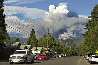
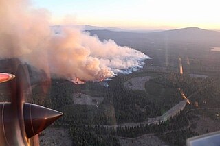
The Bush Fire was a human-caused wildfire that started in the Tonto National Forest northeast of Phoenix, Arizona. It burned 193,455 acres (78,288 ha). The fire started on June 13, 2020 near the intersection of Bush Highway and SR 87 and was fully contained on July 6, 2020

<span class="mw-page-title-main">2020 Utah wildfires</span> Wildfire season

The 2020 Utah wildfire season was a series of prominent wildfires throughout the state of Utah, lasting from June 1 through October 30, as defined by state law. Part of the 2020 Western United States wildfire season, Utah saw record-breaking numbers of human-caused fires. The largest fire of the season, the East Fork Fire, burned an area of 89,568 acres. In total, the suppression costs for the fires amounted to at least $103 million.

<span class="mw-page-title-main">Apple Fire</span> 2020 wildfire in Riverside, California

The Apple Fire was a wildfire that burned during the 2020 California wildfire season in Cherry Valley south of Oak Glen and north of Beaumont and Banning in Riverside County, California in the United States. The fire ignited on Friday, July 31, 2020 as three separate smaller blazes within the rural canyons along Oak Glen Road before merging and rapidly expanded to 1,900 acres (769 ha) and destroyed at least one home and two outbuildings in the Cherry Valley area. It now covers at least 33,424 acres (13,526 ha) and created "a plume of smoke so massive that it generated its own winds." The fire was sparked by a diesel-burning vehicle that emitted burning carbon.

<span class="mw-page-title-main">Loyalton Fire</span> 2020 wildfire that burnt on the California-Nevada border

The Loyalton Fire was a wildfire burning in Lassen, Plumas and Sierra County, California, and Washoe County, Nevada. The fire burned about 47,029 acres (19,032 ha) in the Tahoe National Forest and Humboldt-Toiyabe National Forest before being fully contained on September 14, 2020.

<span class="mw-page-title-main">August 2020 California lightning wildfires</span> An overview of major wildfires in California during August in the year 2020.

The August 2020 California lightning wildfires were a series of 650 wildfires that ignited across Northern California in mid-August 2020, due to a siege of dry lightning from rare, massive summer thunderstorms, which were caused by an unusual combination of very hot, dry air at the surface, dry fuels, and advection of moisture from the remains of Tropical Storm Fausto northward into the Bay Area. These fires burned between 1,500,000 acres (6,100 km2) to 2,100,000 acres (8,500 km2) within a 2–3 week period. The August 2020 lightning fires included three enormous wildfires: the SCU Lightning Complex, the August Complex, and the LNU Lightning Complex. On September 10, 2020, the August Complex set a record for the single-largest wildfire in the modern history of California, reaching a total area burned of 471,185 acres (1,907 km2). On September 11, the August Complex merged with the Elkhorn Fire, another massive wildfire of 255,039 acres (1,032 km2), turning the August Complex into a monster wildfire of 746,607 acres (3,021 km2).

<span class="mw-page-title-main">North Complex Fire</span> A large complex wildfire in Northern California in 2020

The North Complex Fire was a massive wildfire complex that burned in the Plumas National Forest in Northern California in the counties of Plumas and Butte. 21 fires were started by lightning on August 17, 2020; by September 5, all the individual fires had been put out with the exception of the Claremont and Bear Fires, which merged on that date, and the Sheep Fire, which was then designated a separate incident. On September 8, strong winds caused the Bear/Claremont Fire to explode in size, rapidly spreading to the southwest. On September 8, 2020, the towns of Berry Creek and Feather Falls were immediately evacuated at 3:15 PM PDT with no prior warning, By September 9, 2020, the towns of Berry Creek and Feather Falls had been leveled, with few homes left standing. The fire threatened the city of Oroville, before its westward spread was stopped. The fire killed 16 people and injured more than 100. Among the 16 fatalities was a 16-year-old boy. The complex burned an estimated 318,935 acres (129,068 ha), and was 100% contained on December 3. The fire was managed by the U.S. Forest Service in conjunction with Cal Fire, with the primary incident base in Quincy. The North Complex Fire was the sixth-largest in California's modern history, and the deadliest fire in the 2020 California wildfire season.

<span class="mw-page-title-main">2020 Western United States wildfire season</span> Wildfires in the United States in 2020

The Western United States experienced a series of major wildfires in 2020. Severe August thunderstorms ignited numerous wildfires across California, Oregon, and Washington, followed in early September by additional ignitions across the West Coast. Fanned by strong, gusty winds and fueled by hot, dry terrains, many of the fires exploded and coalesced into record-breaking megafires, burning more than 10.2 million acres of land, mobilizing tens of thousands of firefighters, razing over ten thousand buildings, and killing at least 37 people. The fires caused over $19.884 billion in damages, including $16.5 billion in property damage and $3.384 billion in fire suppression costs. Climate change and poor forest management practices contributed to the severity of the wildfires.

<span class="mw-page-title-main">Bobcat Fire</span> 2020 wildfire in Los Angeles County, California

The Bobcat Fire was a fire that started on September 6, 2020, as part of the 2020 California wildfire season. By December 18, it was fully contained and had burned 115,796 acres (46,861 ha) in the central San Gabriel Mountains, in and around the Angeles National Forest. It is one of the largest fires on record in Los Angeles County to date.

<span class="mw-page-title-main">Cameron Peak Fire</span>

The Cameron Peak fire was a wildfire that started near Chambers Lake, Colorado, 25 miles (40 km) east of Walden and 15 miles (24 km) southwest of Red Feather Lakes near Cameron Pass on August 13, 2020, and was declared 100% contained on December 2, 2020. The fire burnt 208,663 acres through the Arapaho and Roosevelt National Forests in Larimer and Jackson Counties and Rocky Mountain National Park. At its peak, the fire forced the evacuation of over 6,000 residents in Estes Park, Chambers Lake, Rustic, Glacier View Meadows, Red Feather Lakes, Masonville, Glen Haven, Spring Canyon, various small communities along Highway 14, Stove Prairie Landing Road, as well as the Colorado State University Mountain Campus and had over 1,000 personnel fighting the fire. 469 structures were destroyed by the fire, including 220 outbuildings and 42 primary residences. The fire became the largest wildfire in Colorado history, surpassing the Pine Gulch Fire, which had set the same mark just seven weeks prior.

<span class="mw-page-title-main">2020 Lassen County wildfires</span> 2020 wildfire sub-season that burned in Lassen County

The 2020 Lassen County wildfire season included seven large wildfires that burned entirely or in part in Lassen County. A total of 203,296 acres (82,271 ha) of land was burned in Lassen County, making it one of the larger clusters of fires in the 2020 California wildfire season.

<span class="mw-page-title-main">2021 California wildfires</span> An overview of major wildfires in California during the year 2021

The 2021 California wildfire season was a series of wildfires that burned across the U.S. state of California. By the end of 2021 a total of 8,835 fires were recorded, burning 2,568,948 acres (1,039,616 ha) across the state. Approximately 3,629 structures were damaged or destroyed by the wildfires, and at least seven firefighters and two civilians were injured.

<span class="mw-page-title-main">2021 Arizona wildfires</span> Wildfires in Arizona during spring and summer 2021

The 2021 Arizona wildfire season was a series of wildfires that burned across the state of Arizona, United States. Wildfires across the state burned 524,428 acres (212,228 ha) of land in at least 1,773 fires throughout the state, fueled in part by a drought, hot temperatures, and thunderstorms producing dry lightning. At one point in late June, over 20 active wildfires were burning across the state.

<span class="mw-page-title-main">Backbone Fire</span> 2021 wildfire in Arizona

The Backbone Fire was a wildfire that started near Payson, Arizona on June 16, 2021. The fire burned 40,855 acres (16,533 ha) was fully contained on July 19, 2021.

References

  1. "National Large Incident YTD Report" (PDF). gacc.nifc.gov. Archived from the original (PDF) on 2020-12-29. Retrieved 30 October 2021.
  2. "Arizona's 2020 Wildfire Season Among Worst in Past Decade". usnews.com. Associated Press. Retrieved 30 October 2021.
  3. Romero, Simon (30 April 2021). "'Firefighters Out There in the Snow': Wildfires Rage Early in Parched West". The New York Times. Retrieved 30 October 2021.
  4. "Drought expected to persist in much of the Western US through 2022 and beyond, according to NOAA report". abcnews.go.com. Daniel Manzo. Retrieved 30 October 2021.
  5. "Arizona wildfires grow as flames flicker throughout Desert Southwest and California". washingtonpost.com. Matthew Cappucci and Andrew Freedman. Retrieved 30 October 2021.
  6. "National Large Incident YTD Report" (PDF). gacc.nifc.gov. Archived from the original (PDF) on 2020-12-29. Retrieved 30 October 2021.
  7. "Here are the 5 largest wildfires in Arizona history". ktar.com. 22 June 2020. Retrieved 30 October 2021.
  8. "Return of the non-soon: Arizona's second dry monsoon season breaks records". azcentral.com. Madeline Ackley. Retrieved 30 October 2021.
  9. "2020 Drought Update: A Look at Drought Across the United States in 15 Maps". drought.gov. NIDIS/NOAA. Retrieved 30 October 2021.
  10. "This calculation shows Monsoon 2020 was the driest ever in the Valley. Here's what that means". 12news.com. Cameron La Fontaine. October 2020. Retrieved 30 October 2021.
  11. "Arizona's 2020 wildfire season among worst in past decade". apnews.com. AP News. 27 January 2021. Retrieved 30 October 2021.
  12. "Facing a record increase in coronavirus cases, Arizona is besieged by wildfires". cnn.com. Drew Kann. 18 June 2020. Retrieved 30 October 2021.
  13. "Maricopa County COVID-19 Data". maricopa.gov. Retrieved 30 October 2021.
  14. "Coronavirus challenging for crews fighting Arizona wildfires". abc15.com. Associated Press. 26 July 2020. Retrieved 30 October 2021.
  15. "Wildfire Smoke and COVID-19". cdc.gov. CDC. Retrieved 30 October 2021.
  16. "'East Desert Fire' fully contained north of Cave Creek Regional Park". abc15.com. abc15.com staff. 17 May 2020. Retrieved 30 October 2021.
  17. "Jackrabbit Fire near Wickenburg grows to more than 2,000 acres". azcentral.com. Helena Wegner. Retrieved 30 October 2021.
  18. "Cave Creek couple makes miraculous discovery after returning from destructive Ocotillo Fire". 12news.com. Mitch Carr. 11 June 2020. Retrieved 30 October 2021.
  19. "Ocotillo Fire". inciweb.nwcg.gov. Arizona Department of Forestry and Fire Management - State Office. Retrieved 30 October 2021.
  20. "Bush Fire now one of the largest wildfires in AZ history, burning over 186,000 acres". azfamily.com. 3TV/CBS 5. Retrieved 30 October 2021.
  21. "Bush Fire". inciweb.nwcg.gov. Tonto National Forest. Retrieved 30 October 2021.
  22. "Central Fire spreads east from New River, AZ". wildfiretoday.com. Bill Gabbert. 21 June 2020. Retrieved 30 October 2021.
  23. "Central Fire". inciweb.nwcg.gov. Arizona Department of Forestry and Fire Management - State Office. Retrieved 30 October 2021.
  24. "Evacuees allowed to go home after Aquila fire scorched almost 900 acres in north Phoenix". azfamily.com. ARIZONA'S FAMILY DIGITAL NEWS STAFF. Retrieved 30 October 2021.
  25. "Aquila Fire". inciweb.nwcg.gov. Arizona Department of Forestry and Fire Management - State Office. Retrieved 30 October 2021.
  26. "Painted Wagon Fire damaging structures northwest of metro Phoenix". ktar.com. 25 June 2020. Retrieved 30 October 2021.
  27. "Open Incidents (Prepared 07/14/2020 18:44)". wildcad.net. Archived from the original on 2020-07-15. Retrieved 30 October 2021.
  28. "Goldfield Fire 100 percent contained, burned almost 2,000 acres". fox10phoenix.com. FOX 10 Phoenix. 10 August 2020. Retrieved 30 October 2021.
  29. "Rolls Fire causes hazy conditions in Fountain Hills area". 12news.com. 12 News. 19 August 2020. Retrieved 30 October 2021.
  30. "Rolls Fire". inciweb.nwcg.gov. Tonto National Forest. Retrieved 30 October 2021.
  31. "Bolt Fire". data.desertsun.com. Tonto National Forest. Retrieved 30 October 2021.
  32. "Three homes destroyed in Sears Fire, grows to 14,476 acres". azfamily.com. ARIZONA'S FAMILY DIGITAL NEWS STAFF. Retrieved 30 October 2021.
  33. ""Bush Fire" northeast of Phoenix spreads east toward Browns Peak". wildfiretoday.com. Bill Gabbert. 21 June 2020. Retrieved 30 October 2021.
  34. "Bush Fire: Apache Lake in 'Go' Evacuation Status". data.knoxnews.com. knoxnews. Retrieved 30 October 2021.
  35. "Wildfires rage in the West, more gusty winds and extreme dry conditions expected". abcnews.go.com. Max Golembo. Retrieved 30 October 2021.
  36. "Bush Fire Update June 17, 2020". inciweb.nwcg.gov. InciWeb. Retrieved 30 October 2021.
  37. "Giant wildfire near Phoenix continues to grow as Arizona coronavirus cases spike". nbcnews.com. Tim Stelloh. 18 June 2020. Retrieved 30 October 2021.
  38. "Arizona's Bush Fire burns through about 115,000 acres". upi.com. Sommer Brokaw. Retrieved 30 October 2021.
  39. "Firefighters battling the "Bush Fire" on both sides of the Mazatzal Mountains". wildfiretoday.com. Bill Gabbert. Retrieved 30 October 2021.
  40. "Arizona wildfires force hundreds of evacuations amid COVID-19 spike". deseret.com. Herb Scribner. 17 June 2020. Retrieved 30 October 2021.
  41. "Firefighters making progress on the Bush Fire east of Phoenix". wildfiretoday.com. Bill Gabbert. 21 June 2020. Retrieved 30 October 2021.
  42. "The Bush Fire is now the 5th largest in Arizona's history as firefighters battle multiple blazes". cnn.com. Joe Sutton and Hollie Silverman. 23 June 2020. Retrieved 30 October 2021.
  43. "BUSH FIRE EVACUATION ORDER UPDATE". twitter.com. Maricopa County Sheriff's Office. Retrieved 31 October 2021.
  44. "Evacuations lifted for 190,200-acre 'Bush Fire' in Tonto National Forest; wildfire now 98% contained". fox10phoenix.com. Stephanie Olmo , Anita Roman , Steve Nielsen and Associated Press. 13 June 2020. Retrieved 31 October 2021.
  45. "Bush Fire burning 193,455 acres in central Arizona is 98% contained". 12news.com. 12 News. 28 June 2020. Retrieved 31 October 2021.
  46. "HIGH WINDS RETURN TO THE FIRE AREA – EXPECT VISIBLE SMOKE… (BUSH FIRE WILDFIRE)". az-phc.com. Anonymous. Retrieved 31 October 2021.
  47. "Bush Fire burning 193,455 acres in central Arizona is 98% contained". 12news.com. 12 News. 28 June 2020. Retrieved 31 October 2021.
  48. "Incident Overview". InciWeb. Archived from the original on 2020-06-15. Retrieved 15 June 2020.
  49. "Bush Fire in Tonto National Forest now largest fire in the U.S." azcentral.com. Retrieved 31 October 2021.
  50. "Arizona's Bush Fire now fifth largest wildfire in state history, blaze grows by 10,000 acres". foxnews.com. Travis Fedschun. 21 June 2020. Retrieved 31 October 2021.
  51. "Central Fire, northeast of New River, grows to 4,517 acres". azfamily.com. Jessica Goodman. Retrieved 31 October 2021.
  52. "Central Fire spreads east from New River, AZ". wildfiretoday.com. Bill Gabbert. 21 June 2020. Retrieved 31 October 2021.
  53. "Central Fire". InciWeb. Archived from the original on 2020-06-30. Retrieved 31 October 2021.
  54. "Smoke on the Central Fire Interior". inciweb.nwcg.gov. Arizona Department of Forestry and Fire Management - State Office. Retrieved 31 October 2021.
  55. "Smoke Outlook for 6-22 & 23". InciWeb. Archived from the original on 2020-06-30. Retrieved 31 October 2021.
  56. "Central Fire Information - InciWeb the Incident Information System". InciWeb. Retrieved 30 June 2020.
  57. "Ocotillo Fire". inciweb.nwcg.gov. Arizona Department of Forestry and Fire Management - State Office. Retrieved 31 October 2021.
  58. "Evacuations ordered for the Ocotillo Fire near Cave Creek, AZ". wildfiretoday.com. Bill Gabbert. 30 May 2020. Retrieved 31 October 2021.
  59. "Ocotillo Fire in Cave Creek is 10% contained, 980 acres burned". ktar.com. June 2020. Retrieved 31 October 2021.
  60. "Evacuation order to be lifted Tuesday for Ocotillo Fire in Cave Creek". ktar.com. Danny Shapiro. June 2020. Retrieved 31 October 2021.
  61. "Ocotillo Fire in Cave Creek now 100% contained". fox10phoenix.com. Associated Press. 30 May 2020. Retrieved 31 October 2021.
  62. "Ocotillo Fire in Cave Creek is 100% contained, residents can go home". azfamily.com. ARIZONA'S FAMILY DIGITAL NEWS STAFF. Retrieved 31 October 2021.
  63. "MAP: Aquila Fire forces evacuations of homes, evacuation center set up in north Phoenix". abc15.com. abc15.com staff. 24 June 2020. Retrieved 31 October 2021.
  64. "Evacuees allowed to go home after Aquila fire scorched almost 900 acres in north Phoenix". azfamily.com. ARIZONA'S FAMILY DIGITAL NEWS STAFF. Retrieved 31 October 2021.
  65. "Aquila Fire". inciweb.nwcg.gov. Arizona Department of Forestry and Fire Management - State Office. Retrieved 30 October 2021.
  66. "Painted Wagon Fire burns nearly 500 acres west of Wittmann; fully contained". fox10phoenix.com. 25 June 2020. Retrieved 31 October 2021.
  67. "Painted Wagon Fire near Wittmann burns 550 acres, destroys 5 structures". azfamily.com. ARIZONA'S FAMILY DIGITAL NEWS STAFF. Retrieved 31 October 2021.
  68. "UPDATE: Forest Service implements area closure due to Sears Fire". inciweb.nwcg.gov. Tonto National Forest. Retrieved 1 November 2021.
  69. "Sears Fire near Cave Creek burns 14,476 acres, now 60% contained". fox10phoenix.com. Ty Brennan , Alexa Vagnozzi and FOX 10 Staff. 25 September 2020. Retrieved 1 November 2021.
  70. "FINAL UPDATE: Sears Fire - Oct. 4". inciweb.nwcg.gov. Tonto National Forest. Retrieved 1 November 2021.
  71. "Sears Fire". inciweb.nwcg.gov. Tonto National Forest. Retrieved 1 November 2021.
  72. "How America's hottest city will survive Climate Change". washingtonpost.com. Retrieved 1 November 2021.
  73. "National Large Incident YTD Report" (PDF). gacc.nifc.gov. Archived from the original (PDF) on 2020-12-29. Retrieved 30 October 2021.