A11 road (England)

Last updated

UK road A11.svg
A11
A11 road map.png
Route information
Maintained by National Highways and London Streets
Length112.4 mi (180.9 km)
Major junctions
Western end Aldgate, City of London
Major intersectionsUK road A13.svg A13
UK road A12.svg A12
UK-Motorway-M11.svg M11 Junction 9.svg
UK road A505.svg A505
UK road A14.svg A14
(UK road A142.svg A142)
UK road A1101.svg A1101
UK road A1065.svg A1065
UK road A134.svg A134
UK road A1066.svg A1066
UK road A47.svg A47
UK road A140.svg A140
Eastern end Norwich
Location
Country United Kingdom
Constituent country England
Primary
destinations
Stratford
Newmarket
Thetford
Bishop's Stortford
Harlow
Woodford
Road network
UK road A10.svg A10 UK road A12.svg A12

The A11 is a major trunk road in England. It originally ran roughly north east from London to Norwich, Norfolk. It now consists of a short section in Inner London and a much longer section in Cambridgeshire, Suffolk and Norfolk. The lengthy section between these was renumbered as a result of the opening of the M11 in the 1970s and then the A12 extension in 1999.

Contents

It also multiplexes/overlaps with the A14 on the Newmarket bypass.

Route

City of London

All this part has been declassified and is now a minor road. Thus the A11 now starts at Aldgate, just inside the eastern boundary of the City of London. The first stretch is Whitechapel High Street, east of the junction with Mansell Street. In a complex reworking of the roads since the days of the Aldgate gyratory system, it is two-way, but the east-bound section is part of the ring-road that retained a one-way system south of this junction, but the westbound section is for local access and motorists have to U-turn to avoid entering the congestion charging zone.

Tower Hamlets

East of Aldgate station, the A11 enters the London Borough of Tower Hamlets and the East End of London. It becomes Whitechapel High Street (containing Aldgate East Underground station), again part of the Aldgate one-way system. The A11 passes through Whitechapel, past Whitechapel station and the Royal London Hospital.

The A11 is named Mile End Road where it runs through Mile End; the Green Bridge carries Mile End Park over the A11 / Mile End Road Mile end green bridge 1.jpg
The A11 is named Mile End Road where it runs through Mile End; the Green Bridge carries Mile End Park over the A11 / Mile End Road

It becomes Mile End Road at the eastern end of Whitechapel Road, at Mile End Gate, the former toll gate for the turnpike. It passes Stepney Green Underground station, with Stepney to the south, and continues through Mile End, passing the Mile End Underground station. Next, as it continues through Bow, it becomes Bow Road, passing Bow Road Underground station and Bow Church DLR station.

There is a dual carriageway flyover over the Bow Interchange roundabout, a junction with the A12. However at the end of the flyover, as the road crosses into the London Borough of Newham, the A11 designation disappears and it instead becomes the A118. This renumbering followed the opening of the A12 extension in 1999, to make the former A11 seem a less important road and encourage traffic to use the new dual carriageway between there and Leytonstone.

Cambridgeshire and Suffolk

Passing south underneath the A1307 Junction near to Babraham, Cambridgeshire. A11 - A1307 bridge near Babraham, Cambridgeshire.jpg
Passing south underneath the A1307 Junction near to Babraham, Cambridgeshire.

The road number A11 reappears at M11 Junction 9A on the border between Essex and Cambridgeshire, and it is now a trunk road. It roughly follows the route of a Roman road for the remainder of its length.

The A11 formerly went through Newmarket; that stretch is now the A1304. The Newmarket bypass, opened to traffic in July 1975, [1] is a dual carriageway. The western end is the A11, but most of its length is a multiplex/overlap with the A14. The A11 re-appears north-east of Newmarket, and remained a dual carriageway. The road bypasses Barton Mills before entering Norfolk in the Thetford Forest, passing the 113-foot-tall (34 m) Elveden War Memorial. This section of the road opened as a dual carriageway on 12 December 2014. This completes the dualling of the trunk road between Norwich and London.

Norfolk

Thickthorn Interchange between the A47 and A11. Thickthorn Interchange - geograph.org.uk - 73633.jpg
Thickthorn Interchange between the A47 and A11.

The upgrading of the final section of single carriageway 'Thetford Straight' between Barton Mills and Thetford (opened December 2014) means the road is dual carriageway all the way to Norwich. The road continues northeast bypassing Thetford, Attleborough and Wymondham. The A11 originally ran through the centre of all three towns giving rise to congestion which frequently became the focus of delays on the route. It also passes the Snetterton Circuit motor racing venue. On entering Norwich, it becomes single carriageway again and is called Newmarket Road. It terminates at the St Stephens Street roundabout near the city centre.

Various sections of the A11 between the junction with the M11 in Cambridgeshire and Norwich have recently been upgraded to dual carriageway. The Roudham Heath to Attleborough section was dualled in 2003 [2] and the Attleborough bypass was dualed in 2007. [3] The previously single carriageway road between Thetford and the Fiveways roundabout is now dual carriageway and opened in December 2014.

Cycling

London

Cycle Superhighway 2 (CS2) runs alongside the A11 between Aldgate and the A12 in Bow. One-way cycle tracks run along either side of the A11 through Whitechapel, Mile End, and Bow, carrying cyclists from the City to Stratford. The route runs unbroken; the route is signposted and marked using blue paint and cycle icons.

At Bow, where the A11 meets the A12, CS2 leaves the main carriageway along slip roads, and cyclists may congregate at an Advanced Stop Line - in both directions - to cross the roundabout, rejoining the main carriageway on the other side of the roundabout. East of Bow, CS2 runs along either side of the A118 to Stratford station, and cycle lanes are provided as far as Ilford. [4]

Norwich

The Wymondham to Sprowston Pedalway runs along the A11/Newmarket Road. To the west, the Pedalway joins the A11 at Eaton. Westbound destinations include Cringleford, Hethersett, and Wymondham. Running northeast, the Pedalway is signposted along a shared-use path adjacent to the Newmarket-bound (westbound) carriageway. The route crosses the A140/Daniels Road and continues along Newmarket Road as a shared-use path. It leaves the A11 in a northerly direction at the junction with the A1056/Ipswich Road. The route runs through Norwich City Centre to Sprowston. [5]

Completed improvements

A11 Fiveways – Thetford Improvement

Proposed A11 Fiveways - Thetford Improvement.png
The location of the proposed Fiveways – Thetford Improvement
Location Suffolk, Norfolk
Proposer Highways Agency
Cost estimate£113-157m (8/08)
Start date2012
Completion date2015
StakeholdersHighways Agency
Geometry KML

Proposals to dual 14.8 km of the road between the Fiveways Roundabout at Barton Mills, bypassing Elveden to the North and joining the western end of the Thetford Bypass had been discussed for many years without any developments being made. [6] Draft Orders together with an Environmental Statement were published in Autumn 2008. [7] The Labour government's Secretary of State for Transport announced the scheme would be brought forward by 18 months to 2010 with an open date of 2013 in November 2008 in response to the Financial crisis of 2007–2008. [8] Supporters expressed concern in September 2010 that the scheme would be cancelled as part of the coalition government's comprehensive spending review noting that the report from the public inquiry had not yet been signed off by the Department for Transport. [9]

The Highways Agency has published an official map of the proposed scheme and a Google overlay map is also available. The original cost estimate was £30 million rising to £60 million in March 2007 [10] and then to £113-£157 million by August 2008. [11]

The project received strong support from local business groups and local government [11] and was expected to reduce journey times by 3 minutes off-peak and up to 25 minutes at peak times. [12] Environmental campaign groups believed that in a time of economic downturn it would be better to invest in local public transport rather than on costly road schemes. [13] On 20 October 2010, the government approved the scheme, indicating that the works would continue. [14] The Elveden Bypass opened during Easter 2014 with one lane in use each way. The full dual carriageway between Barton Mills and Thetford was opened on 12 December 2014 by transport secretary Patrick McLoughlin. [15]

Former sections

City of London

Originally, the A11 started at the Bank of England in the City of London, next to Bank Underground station, and went eastwards along Cornhill and Leadenhall Street, past Aldgate Pump and along Aldgate. Hence leading to the current A11 starting point at Aldgate.

Newham

From Bow Interchange, A118 briefly becomes a dual carriageway as it crosses the valley of the River Lea. This dual carriageway section ends at Stratford town centre, and was a one-way system until 16 September 2018, [16] the eastbound road of which, Great Eastern Road, passed Stratford station. The formerly westbound road is now two way, called Broadway and The Grove; the latter road runs north–south. The old A11 then becomes Leytonstone Road; Maryland railway station turns northwards on the corner where the name change occurs. Meanwhile, the A118 heads eastward along its route towards Ilford and Romford. The A112 also joins the one-way system, heading north–south.

Waltham Forest

North of Maryland, the old A11 crosses from the London Borough of Newham into the London Borough of Waltham Forest and becomes High Road Leytonstone, passing under the Gospel Oak to Barking line.

Redbridge

Once past the Green Man Interchange, the former A11 route enters the London Borough of Redbridge and briefly becomes a southern extension to the A113 before turning into the A1199 (a duplicate designation, given that there is another A1199 in Islington), and is called Hollybush Hill, Woodford Road and High Road Woodford Green. It crosses over the A406 at Gates Corner (named after a Ford car showroom, which was turned into residential flats in 2006), but since the A406 was widened when the M11 was constructed there are no slip roads for interchange and the old A11 passes over the top. It merges with the A104 Woodford New Road by the Statue of Winston Churchill and becomes the A104 High Road Woodford Green. North, the road was A11 until the M11 opened in the 1970s, triggering the downgrading of the A11 between Woodford and Stump Cross (see below). Just before leaving London for Essex, the A104 becomes Epping New Road.

Essex, Hertfordshire and Cambridgeshire

Shortly after entering Essex, the A11 enters Epping Forest, following the mainly straight course of the Epping New Road turnpike constructed during the second quarter of the nineteenth century, alongside the boundary between Waltham Abbey and Loughton. It then reaches the Wake Arms Roundabout and becomes the B1393. Just after leaving the forest, it crosses the M25 motorway (here lowered into a cut-and-cover tunnel), then continuing through Epping. The B1393 ends at junction 7 of the M11, and the route of the A11 goes along the A414 through the eastern suburbs of Harlow, having been rerouted slightly to the west at the end of the 1950s to avoid passing through Potter Street. The road then becomes the A1184 and goes through Sawbridgeworth: through the rest of the Essex stretch between Harlow and Stump Cross the road follows a more traditionally English course, characterised by bends of varying and sometimes uneven radii, with just one straight mile (1.6 km) (to the south of Littlebury) along the north Essex stretch.

At Thorley Wash, just south of Bishop's Stortford, the A1184 turns sharp left to become part of the Bishop's Stortford bypass, but the route of the A11 becomes the B1383 and goes through Thorley Street, Bishop's Stortford, Stansted Mountfitchet, and Quendon. It crosses the M11 and passes Audley End. The B1383 ends at 9A (Stump Cross), the end of a spur that comes off the M11 at Junction 9, near Great Chesterford. From there, the former A11 section aligns once more with the current A11.

Related Research Articles

<span class="mw-page-title-main">A14 road (England)</span> Major road in England

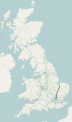
The A14 is a major trunk road in England, running 127 miles (204 km) from Catthorpe Interchange, a major intersection at the southern end of the M6 and junction 19 of the M1 in Leicestershire to the Port of Felixstowe, Suffolk. The road forms part of the unsigned Euroroutes E24 and E30. It is the busiest shipping lane in East Anglia carrying anything from cars to large amounts of cargo between the UK and Mainland Europe.

<span class="mw-page-title-main">A12 road (England)</span> Road in England

The A12 is a major road in Eastern England. It runs north-east/south-west between London and the coastal town of Lowestoft in the north-eastern corner of Suffolk, following a similar route to the Great Eastern Main Line until Ipswich. A section of the road between Lowestoft and Great Yarmouth became part of the A47 in 2017. Between the junctions with the M25 and the A14, the A12 forms part of the unsigned Euroroute E30. Unlike most A roads, this section of the A12, together with the A14 and the A55, has junction numbers as if it were a motorway.

<span class="mw-page-title-main">Attleborough</span> Human settlement in England

Attleborough is a market town and civil parish located on the A11 between Norwich and Thetford in Norfolk, England. The parish is in the district of Breckland and has an area of 21.9 square kilometres (8.5 sq mi).

<span class="mw-page-title-main">N11 road (Ireland)</span> National primary road in Ireland

The N11 road is a national primary road in Ireland, running for 129 km (80 mi) along the east side of Ireland from Dublin to Wexford. It passes close to Bray, Greystones, Wicklow, Arklow, Gorey, and Enniscorthy. Beyond Wexford, the route continues to Rosslare as the N25. The road forms part of European route E01. As of July 2019 the N11/M11 is of dual carriageway or motorway standard from Dublin as far as Oilgate in County Wexford.

<span class="mw-page-title-main">A47 road</span> Road in England

The A47 is a major trunk road in England linking Birmingham to Lowestoft, Suffolk, maintained and operated by National Highways. Most of the section between Birmingham and Nuneaton is now classified as the B4114. From Peterborough eastwards, it is a trunk road.

<span class="mw-page-title-main">A46 road</span> Road in England

The A46 is a major A road in England. It starts east of Bath, Somerset and ends in Cleethorpes, Lincolnshire, but it does not form a continuous route. Large portions of the old road have been lost, bypassed, or replaced by motorway development. Between Leicester and Lincoln the road follows the course of the Roman Fosse Way, but between Bath and Leicester, two cities also linked by the Fosse Way, it follows a more westerly course.

<span class="mw-page-title-main">A10 road (England)</span> Road in England

The A10 is a major road in England which runs between The City of London and King's Lynn in Norfolk.

<span class="mw-page-title-main">A13 road (England)</span> Major road in England

The A13 is a major road in England linking Central London with east London and south Essex. Its route is similar to that of the London, Tilbury and Southend line via Rainham, Grays, Tilbury, Stanford-Le-Hope & Pitsea, and runs the entire length of the northern Thames Gateway area, terminating on the Thames Estuary at Shoeburyness. It is a trunk road between London and the Tilbury junction, a primary route between there and Sadlers Hall Farm near South Benfleet, and a non-primary route between there and Shoeburyness.

<span class="mw-page-title-main">Eastern Avenue, London</span> Road in Greater London, England

The Eastern Avenue is one of the main roads leading out of London. The 10-mile (16 km) road is part of the A12, a 129-mile road connecting Blackwall in London with the seaside town of Lowestoft in Suffolk.

<span class="mw-page-title-main">A120 road</span> Road in the east of England

The A120 is an A-road in England, which runs between Puckeridge in Hertfordshire and Harwich in Essex.

<span class="mw-page-title-main">A118 road</span> Road in London, England

The A118 is a road in east London, England which links Bow Interchange with Gallows Corner in Romford via Stratford and Ilford.

<span class="mw-page-title-main">A505 road</span> Road in southern England

The A505 is a road in the East of England. It follows part of the route of the Icknield Way and the corresponding Icknield Way Path and runs from Leighton Buzzard in Bedfordshire to the A11 Abington Interchange North in Cambridgeshire.

<span class="mw-page-title-main">East Cross Route</span> Road in East London

East Cross Route (ECR) is a dual-carriageway road constructed in east London as part of the uncompleted Ringway 1 as part of the London Ringways plan drawn up the 1960s to create a series of high speed roads circling and radiating out from central London. The road was constructed between 1967 and 1973 and runs from Hackney Wick in north-east London, through the Blackwall Tunnel, to Kidbrooke in south-east London. The ECR was initially designated as part of the A102, but has, subsequently, been partially renumbered so that sections of it are now the A2 and A12.

<span class="mw-page-title-main">A140 road</span> Road in England

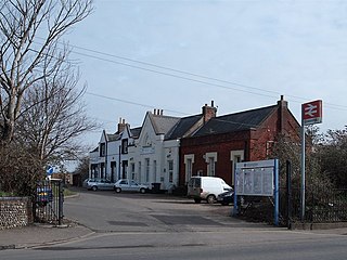
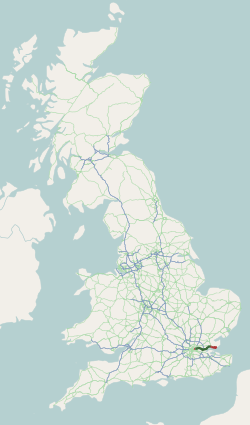
The A140 is an 'A-class' road in Norfolk and Suffolk, East Anglia, England partly following the route of the Roman Pye Road. It runs from the A14 near Needham Market to the A149 south of Cromer. It is of primary status for the entirety of its route. It is approximately 56 miles (90 km) in length.

<span class="mw-page-title-main">A143 road</span> Road in England

The A143 is a road that runs from the Gorleston-on-Sea area of Great Yarmouth, in Norfolk to Haverhill in Suffolk.

<span class="mw-page-title-main">A146 road</span> A road in East Anglia, England

The A146 is an A road that connects Norwich in Norfolk and Lowestoft in Suffolk, two of East Anglia's largest population centres. It is around 27 miles (43 km) in length and has primary classification along its entire route. It is mainly single carriageway throughout its route, with the exception of a section of dual carriageway on the southern edge of Norwich.

<span class="mw-page-title-main">A1065 road</span> Road in East Anglia, England

The A1065 is a main road in the English region of East Anglia. It provides the principal road connection to parts of the west and north of the county of Norfolk from Newmarket and points south of there, including London. It runs from a junction near Mildenhall, to a junction on the western outskirt of Fakenham.

<span class="mw-page-title-main">A130 road</span> Road in Essex, England

The A130 is a major road in England linking Howe Green, near Chelmsford, the county town of Essex, with Canvey Island in the south of that county. It is a primary route for some of its length, only losing that status south of the A13 junction at Sadlers Farm roundabout as it nears its terminus on Canvey Island. It was originally a much longer cross-country route.

<span class="mw-page-title-main">Bow Interchange</span>

Bow Interchange is a busy grade-separated road junction in London, England, on the East Cross Route between Bow, Stratford, and Bromley-by-Bow at a point where the London Boroughs of Tower Hamlets and Newham meet. It is a triple-level junction where the East Cross Route, Bow Road, and Stratford High Street meet. The River Lea runs underneath the junction.

<span class="mw-page-title-main">Green Man, Leytonstone</span> Pub and road junction in Leytonstone, London

The Green Man is a pub and road junction on High Road, Leytonstone, London. The pub has been rebranded as part of the O'Neill's chain. The current 1920s building replaced an earlier public house, close to the original site; which was built around 1668 and mentioned by Daniel Defoe.

References

  1. "News: And Newmarket by-pass". Autocar . 143 (nbr 4105): 27. 12 July 1975.
  2. "A11 Roudham Heath to Attleborough Dualling". Highways Agency. Archived from the original on 4 July 2008. Retrieved 5 November 2008.
  3. "A11 Attleborough Bypass Improvement". Highways Agency. Archived from the original on 6 September 2008. Retrieved 5 November 2008.
  4. "CS2: Stratford to Aldgate" (PDF). Transport for London (TfL). Archived (PDF) from the original on 25 May 2019. Retrieved 11 May 2020.
  5. "Norwich Cycle Map" (PDF). Norwich City Council . Archived (PDF) from the original on 11 May 2020. Retrieved 11 May 2020.
  6. "A11 Fiveways – Thetford Improvement". Highways Agency. Archived from the original on 5 June 2009. Retrieved 23 July 2009.
  7. "A11 Fiveways to Thetford Improvement – Project timeline". Highways Agency. Archived from the original on 3 December 2009. Retrieved 23 July 2009.
  8. "Major boost for East of England as planned A11 dualling brought forward". Department for Transport (East). Archived from the original on 16 July 2011. Retrieved 18 November 2008.
  9. "MPs from Norfolk and Suffolk fight to keep A11 funding". BBC News. 24 September 2010. Archived from the original on 25 September 2010. Retrieved 25 September 2010. MPs have called on businesses, residents and councils to lobby government ministers to remind them of the importance of widening the A11
  10. "Estimating and monitoring the costs of building roads in England". National Audit Office. Archived from the original on 6 June 2009. Retrieved 23 July 2009.
  11. 1 2 "Government told it's high time to dual the A11 as public petition launched by Norfolk County Council". Norfolk county council. Archived from the original on 11 September 2008. Retrieved 5 November 2008.
  12. "Why dualling the A11 makes business sense". BIZonline. Retrieved 5 November 2008.[ dead link ]
  13. "Road building won't stop the recession". Campaign for Better Transport (CBT) . Retrieved 18 November 2008.
  14. The works were due to start January 2013 and finish September 2014 "A11 dualling set to be given go-ahead". Eastern Daily Press (Norfolk, UK). 20 October 2010. Archived from the original on 23 October 2010. Retrieved 20 October 2010.
  15. "A11 dual carriageway opens". UK Government. Retrieved 31 December 2014.
  16. "Switch to two-way traffic on Stratford Broadway". Newham Council.
Template:Attached KML/A11 road (England)
KML is from Wikidata