Ambedkar Nagar district

Last updated

Ambedkar Nagar
Hanswar koat.JPG
Fort at Hanswar
India Uttar Pradesh districts 2012 Ambedkar Nagar.svg
Location of Ambedkar Nagar district in Uttar Pradesh
CountryFlag of India.svg  India
State Uttar Pradesh
Division Ayodhya
Established29 September 1995;28 years ago (1995-09-29)
Headquarters Akbarpur
Tehsils Akbarpur, Tanda, Jalalpur, Alapur, Bhiti
Government
   Lok Sabha constituencies 1. Ambedkar Nagar (Lok Sabha constituency) - Akbarpur, Jalalpur, Katehari, Tanda
2. Sant Kabir Nagar (Lok Sabha constituency) - Alapur
   Vidhan Sabha constituencies 1. Katehari
2. Akbarpur
3. Tanda
4. Jalalpur
5. Alapur
   District Magistrate Avinash Singh, IAS
   Superintendent of Police Kaustubh, IPS
Area
  Total2,350 km2 (910 sq mi)
Population
 (2011)
  Total2,397,888
  Density1,000/km2 (2,600/sq mi)
Demographics
   Literacy 74.37%
   Sex ratio 976
Time zone UTC+05:30 (IST)
Vehicle registration UP-45
Major highways NH 28, NH 128, NH 233A, NH 233B State Highway 30 (Uttar Pradesh)
Website Official Website

Ambedkar Nagar is one of the 75 districts of the Indian state of Uttar Pradesh. This district is a part of Ayodhya division in the Awadh region of the state. This district was established on 29 September 1995 by carving out parts of the erstwhile Faizabad district (now Ayodhya district). [1] It was created by the then Chief Minister Mayawati and named in memory of B. R. Ambedkar, who worked for the advancement of the depressed classes. The total area of Ambedkar Nagar district is 2350 Sq. Km. [2]

Contents

Geography

Topography

Ambedkar Nagar is located on the north-eastern part of Uttar Pradesh. It lies between 26° 09' N to 26° 40' N latitudes and 82° 12' E to 83° 05' E longitudes. It is bounded on the north by Basti and Sant Kabir Nagar districts, on the north-east by Gorakhpur district, on the south by Sultanpur district, on the west by Ayodhya district, on the east by Azamgarh district, and on the south east by Shahganj tehsil of Jaunpur district. The total area of the district is 2,520 km2 (970 sq mi)>. The total length of the district from east to west is approximately 75 km (47 mi) and the breadth from north to south is about 42 km (26 mi).

The district of Ambedkar Nagar forms a part of the central Ganga basin. The soils of the Ambedkar Nagar district are alluvium.

The Sarayu river is the main river and is located at the northern boundary of the district. The Tanda, Rajesultanpur, Ramnagar and Baskhari blocks are located along this river and use its water for irrigation. Irrigation in the Baskhari block is also from Lake Devhat, the Rajesultanpur Lake and the Hanswar Lake. Lake Darvan provides water in the Katehari block. The Akbarpur, Bhiti, Bhiyaon, and Jalalpur blocks depend upon smaller rivers and seasonal streams. The city of Akbarpur is situated on the banks of the River Tons (Tamsa), which divides the city into the two parts Akbarpur and Shahzadpur, with the latter being the main commercial centre of the city.

Climate

The climate of the district resembles that of eastern Uttar Pradesh. It is characterised by a rhythm of seasons, which are produced by south-west and north-east monsoon. The reversal of winds takes place twice a year. The climate of the district may be classified into three distinct seasons.

The cold weather season lasts from November to February. In November, the belt of high pressure extends from north-west India and covers the whole of the Uttar Pradesh. The temperature beings to decline and the maximum and minimum are 32.15 and 8.95 °C (89.87 and 48.11 °F) respectively, in this month. The prevailing winds blow from west to east and are influenced by the pressure distribution and pattern of the Himalayas.

Demography

Historical population
YearPop.±% p.a.
1901641,783    
1911604,679−0.59%
1921614,107+0.15%
1931631,356+0.28%
1941691,971+0.92%
1951777,416+1.17%
1961866,321+1.09%
19711,046,122+1.90%
19811,291,125+2.13%
19911,629,353+2.35%
20012,026,876+2.21%
20112,397,888+1.70%
source: [3]

According to the 2011 census Ambedkar Nagar district has a population of 2,397,888, [4] This gives it a ranking of 186th in India (out of a total of 640). [4] The district has a population density of 1,021 inhabitants per square kilometre (2,640/sq mi). [4] Its population growth rate over the decade 2001-2011 was 18.35%. [4] Ambedkar Nagar has a sex ratio of 976 females for every 1000 males, [4] and a literacy rate of 74.37%. 11.71% of the population lives in urban areas. Scheduled Castes make up 24.65% of the population. [4]

The distribution of population in each block is controlled by physical conditions and socio-economic causes. Akbarpur block has the highest share of population (16.56%), followed by Jalalpur (13.80%), Tanda (12.32%), Ramnagar (10.26%), Katehri (10.03%), Bhiyaon (9.78%), Baskhari (9.53%), Jahangirganj (9.17%) and Bhiti (8.55%).

Religion

Religion in Ambedkar Nagar district (2011) [5]
ReligionPercent
Hinduism
82.81%
Islam
16.75%
Other or not stated
0.44%

Hinduism is major religion in Ambedkar Nagar district with 1.985.654 Hindus (82.81%). Islam is second largest religion with 401,678 Muslims (16.75%). Other religions includes 2.536 Christians (0.11%), 1.817 Buddhists (0.08%), 869 Sikhs (0.04%), 235 Jains (0.01%), 5.066 did not stated (0.21%) and 33 did other (<0.01%). [5]

Languages

Languages of Ambedkar Nagar district (2011) [6]

   Hindi (79.45%)
   Awadhi (10.71%)
   Urdu (8.09%)
   Bhojpuri (1.63%)
  Others (0.12%)

The official languages of the district are Hindi and Urdu. The most spoken languages of Ambedkar Nagar district are Hindi and Awadhi. [7]

At the time of the 2011 Census of India, 79.45% of the population in the district spoke Hindi, 10.71% Awadhi, 8.09% Urdu and 1.63% Bhojpuri as their first language. [6]

Cities and towns

Ambedkar Nagar nagar panchayat and nagar palika

Blocks

Major villages

Economy

Ambedkar Nagar is known for its textile industry, power plant, sugar plant and cement manufacturing plant. Tanda town is well known for its "Tanda Terrycot". [8] The major economic activity of the district is agro-based industries, firms small, power looms and farming. There is a thermal power plant belonging to the NTPC called Tanda thermal power plant at Makhdoom Nagar area near Tanda. Jaypee Group (Jaypee Ayoudha Greeding) has set up a cement manufacturing plant at Naseebjot Village near Tanda. The district has a sugar factory called Akbarpur Sugar Mill, which is situated near Mijhaura, about ten kilometres from the district headquarters. Akbarpur is a very important town and district headquarter of Ambedkar Nagar district with active participation in the production of plastic along with farm based products.

In 2006 the Ministry of Panchayati Raj named Ambedkar Nagar one of the country's 250 most backward districts (out of a total of 640). [9] It is one of the 34 districts in Uttar Pradesh currently receiving funds from the Backward Regions Grant Fund Programme (BRGF). [9]

Tourism

The shrine of Ashraf Jahangir Semnani [10] is located in Kicchocha Sharif (Kichhauchha Sharif).

Transport

Bus stations

Railway station

Nearby stations

Education

Medical and engineering colleges

Other colleges

Media

Ambedkar Nagar has some active media groups which continuously give news updates on Ambedkar Nagar news in Hindi, including breaking news and current news. These media groups include Amar Ujala , [11] Dainik Jagaran , Avadhnama Urdu Dainik Bhaskar , Hindustan and Soochna News.[ citation needed ]

Notable people

Ram Manohar Lohia Ram Manohar Lohia 1977 stamp of India.jpg
Ram Manohar Lohia
Arunima Sinha Arunima sinha.png
Arunima Sinha

Related Research Articles

<span class="mw-page-title-main">Ayodhya district</span> District in Uttar Pradesh, India

Ayodhya district is one of the 75 districts in the northern Indian state of Uttar Pradesh. The city of Ayodhya is its administrative headquarters. The district occupies an area of 2,522 square kilometres (974 sq mi), and had a population of 2,470,996 in the 2011 census. Ayodhya district shares its borders with 6 districts of Uttar Pradesh. It is bordered by Gonda and Basti districts on the northern side, Amethi and Sultanpur districts on the south, and Ambedkar Nagar and Barabanki districts share the border on the east and west.

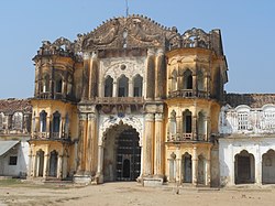
Ashrafpur Kichhauchha is a town and a nagar panchayat in Ambedkar Nagar District in the state of Uttar Pradesh, India. It is well known worldwide as here the shrine of the famous Chisti Sufi saint Sultan Syed Makhdoom Ashraf Jahangir Semnani is located, which attracts millions of devotees irrespective of religion, caste, creed and sex all the year round. The nearest railway station is the Akbarpur station which is about 23 kilometers. Akbarpur station is connected by rail to big cities such as Kolkata, Delhi, Lucknow, Varanasi and Mumbai.

Bilariaganj is the second largest city and a Nagar Palika Parishad in Azamgarh division after its capital city Azamgarh in the state of Uttar Pradesh, India.

Jalalpur is a town, tehsil and a municipal board in Ambedkar Nagar district in the Indian state of Uttar Pradesh, India.

<span class="mw-page-title-main">Akbarpur, Ambedkar Nagar</span> City in Uttar Pradesh, India

Akbarpur is a city, municipal corporation, tehsil, and the administrative headquarters of Ambedkar Nagar district in the state of Uttar Pradesh, India. It is a part of Ayodhya division.

Tanda is a town in Ambedkar Nagar district in the Indian state of Uttar Pradesh situated on the banks of Ghaghara River. It is a nagar palika parishad and is part of Ayodhya division in Uttar Pradesh. The town is situated 20 kilometres (12 mi) north east from district headquarter Akbarpur. Tanda is also a tehsil in the district. It has one of the largest handloom weaving industries for manufacturing varieties like gamchha, lungi, polyester clothing, check-shirt clothes material in state of Uttar Pradesh.

<span class="mw-page-title-main">Hanswar</span> Village in Uttar Pradesh, India

Hanswar is a village in the Ambedkar Nagar district of Uttar Pradesh, India, located east of Tanda. Demographically, Hanswar resembles the rest of the Purvanchal area in which it is located.

Baskhari is a town located in Ambedkar Nagar district in the Indian state of Uttar Pradesh.

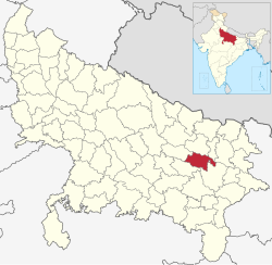
Ambedkar Nagar Lok Sabha constituency is one of the 80 Lok Sabha (parliamentary) constituencies in the Indian state of Uttar Pradesh. This lok sabha constituency came into existence in 1996 as 11th lok sabha was held in April-May 1996. On 29 September 1995 Ambedkar Nagar district carved out from faizabad division in the memory of Baba Saheb Dr. Bhim Rao Ambedkar.

Bhaupur is a village in Akbarpur, Ambedkar Nagar district of Uttar Pradesh, India, located 4.8 miles (7.7 km) in the east of Akbarpur town. It is the part of eleven gram sabha , with 1,750 people, which comes under the gram panchayat, Rukunuddinpur.

Katehri, also spelled as Katehari, is a town in Ambedkar Nagar district in the Indian state of Uttar Pradesh. Katehri is also a block in Ambedkar Nagar district, Uttar Pradesh.

Goshainganj, also known as Gosainganj, is a town and nagar panchayat in the Ayodhya district of the Indian state of Uttar Pradesh. Located 32 km from the district headquarters Ayodhya, Goshainganj has one of the oldest markets of the district.

Rajesultanpur or Raje Sultanpur is a town and nagar panchayat in Ambedkar Nagar district in the Indian state of Uttar Pradesh.

National Highway 233A is a National Highway in India that links Rajesultanpur, Nasirpur, Chhitauna, Gangasagar, Ambedkar Nagar in Uttar Pradesh to Ayodhya in Uttar Pradesh.up

Hirapur is a village in Ambedkar Nagar district, Uttar Pradesh, India. Hirapur is situated 9 kilometres (5.6 mi) east of Tanda Busstand.

Ramnagar, also spelled as Ramnagar Mahuware, is a town in Ambedkar Nagar district, Faizabad division, in the state of Uttar Pradesh, India. It is located on National Highway 233A between Tanda and Rajesultanpur. It is also near Hanswar.

<span class="mw-page-title-main">Jahangirganj</span> Village in Uttar Pradesh, India

Jahangirganj is a nagar panchayat and Market in Ambedkar Nagar district in the Indian state of Uttar Pradesh and is Subpost Office. It is found 45 km towards East from District headquarters Akbarpur, Ambedkar Nagar and 242 km from State capital Lucknow.

Aalapur is a town and tehsil in Ambedkar Nagar district, Uttar Pradesh, India. It is a part of Faizabad division in Uttar Pradesh state. Aalapur is 33 km east of district headquarters Akbarpur city.

Haiderganj is a town in Bikapur tehsil in Ayodhya district of Uttar Pradesh state of India. Haiderganj is 40 km south of district headquarters Ayodhya city.

Dhamhar is a village in Bikapur tehsil, Ayodhya district in the Uttar Pradesh state of India.

References

  1. "History | Ambedkarnagar | India" . Retrieved 3 October 2022.
  2. "Ambedkarnagar | Birthplace Of Ram Manohar Lohiya | India" . Retrieved 8 March 2021.
  3. "Decadal Variation In Population Since 1901". Office of the Registrar General & Census Commissioner, India. Retrieved 30 January 2021.
  4. 1 2 3 4 5 6 "District Census Handbook: Ambedkar Nagar" (PDF). censusindia.gov.in. Registrar General and Census Commissioner of India. 2011.
  5. 1 2 "Table C-01 Population by Religion: Uttar Pradesh". censusindia.gov.in. Registrar General and Census Commissioner of India. 2011.
  6. 1 2 "Table C-16 Population by Mother Tongue: Uttar Pradesh". www.censusindia.gov.in. Registrar General and Census Commissioner of India.
  7. "Ambedkar Nagar district - About" . Retrieved 23 May 2019.
  8. Varma, Subodh (25 February 2017). "Region where almost all kids anaemic | Uttar-Pradesh Election News - Times of India". The Times of India. Retrieved 5 January 2021.
  9. 1 2 Ministry of Panchayati Raj (8 September 2009). "A Note on the Backward Regions Grant Fund Programme" (PDF). National Institute of Rural Development. Archived from the original (PDF) on 5 April 2012. Retrieved 27 September 2014.
  10. 'Hayate Makhdoom Syed Ashraf Jahangir Semnani(1975), Second Edition(2017) ISBN   978-93-85295-54-6, Maktaba Jamia Ltd, Shamshad Market, Aligarh 202002, India.
  11. "Hindi Newspapers". Amar Ujala . Retrieved 13 July 2016.