The United Provinces of Agra and Oudh was a province of India under the British Raj, which existed from 22 March 1902 to 1937; the official name was shortened by the Government of India Act 1935 to United Provinces (UP), by which the province had been commonly known, and by which name it was also a province of independent India until 1950.

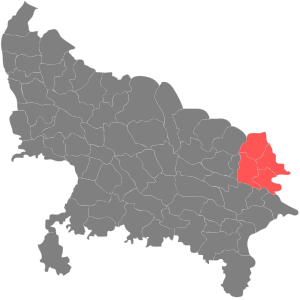
Azamgarh division is one of the 18 administrative geographical units of the northern Indian state of Uttar Pradesh. It was formed on 15 November 1994 after being separated from Gorakhpur division and Varanasi division, with Azamgarh city being the divisional headquarters. Azamgarh division consists of 3 districts:-

The North Eastern Railway is one of the 18 railway zones of Indian Railways. It is headquartered at Gorakhpur.
Mubarakpur is a town and a municipal board in Azamgarh district in the Indian state of Uttar Pradesh. It is located at a distance of 13 km north-east of the district headquarters in Azamgarh.

Basti district is one of the districts of Uttar Pradesh state, India, and a part of Basti Division. Basti city is the district headquarters.

Azamgarh is a city in the Indian state of Uttar Pradesh. It is the headquarters of Azamgarh division, which consists of Ballia, Mau and Azamgarh districts. Azamgarh is situated on the bank of Tamsa River (Tons). It is located 268 km (167 mi) east of the state capital Lucknow and 809 km from national capital, Delhi.

Azamgarh district is one of the three districts of Azamgarh division in the Indian state of Uttar Pradesh.

Mau district is one of the districts of Uttar Pradesh state of India, and Mau town is the district headquarters which is also one of the few remaining areas of handloom saree production in eastern Uttar Pradesh, specializing in Sadiya silk sarees. Mau was carved out as a separate district from Azamgarh on 19 November 1988. It is situated in the south-eastern part of the state with headquarters in Maunath Bhanjan. The district is surrounded by Ghazipur district on the south, Ballia district in the east, Azamgarh district in the west, and by Gorakhpur and Deoria districts on the north; says, Pallavi mishra.

Varanasi division is one of the 18 administrative geographical units of the northern Indian state of Uttar Pradesh. Varanasi city is the administrative headquarters of the division. The division consists of 4 districts, i.e. Varanasi, Chandauli, Ghazipur, and Jaunpur and is loosely equivalent to the Benares State.
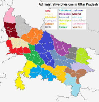
The northern Indian state of Uttar Pradesh, which borders Nepal, comprises 18 administrative divisions. Within these 18 divisions, there are a total of 75 districts. The following table shows the name of each division, its administrative capital city, its constituent districts, and a map of its location.
Chandauli is a town and a nagar panchayat in Chandauli district in the state of Uttar Pradesh, India. It is the administrative headquarters of Chandauli District.
Gorakhpur district is one of the 75 districts of Uttar Pradesh state in northern India. This district is a part of the Gorakhpur division. The city of Gorakhpur, or Gorakhpur is the administrative headquarters of this district and Gorakhpur division. It borders Sant Kabir Nagar district to the west, Kushinagar and Deoria districts to the east, and Maharajganj and Azamgarh districts to the north and south.
Kushinagar is a district of the state of Uttar Pradesh in India situated in the easternmost part of the state. It has the administrative headquarters at Ravindra Nagar Dhoos. The district is named such after the town Kushinagar, a Buddhist pilgrimage site where Gautama Buddha attained parinirvana in the 5th century BCE. Since the independence of India, Kushinagar district was a part of Deoria District and came into existence on 13 May 1994 as a separate district division. It was earlier known as Padrauna and thereafter was renamed Kushinagar on 19 June 1997.
Bilariaganj is the second largest city and a Nagar Palika Parishad in Azamgarh division after its capital city Azamgarh in the state of Uttar Pradesh, India.

Hanswar is a village in the Ambedkar Nagar district of Uttar Pradesh, India, located east of Tanda. Demographically, Hanswar resembles the rest of the Purvanchal area in which it is located.

Basti is a city, municipal board and administrative headquarters of Basti district in the Indian state of Uttar Pradesh. Basti district is a part of Basti division. It is situated 202 kilometres east of state capital Lucknow.

The Uttar Pradesh Expressways Industrial Development Authority (UPEIDA) is an authority set up in 2007 by the Government of Uttar Pradesh to develop expressway projects in the state. The headquarters of UPEIDA is located at Paryatan Bhawan in Gomti Nagar, Lucknow.
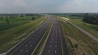
Purvanchal Expressway is a 340.8 km long, 6-lane wide access-controlled expressway in the state of Uttar Pradesh, India. The expressway connects Chand Saray village near Gosainganj in Lucknow district with Haydaria village on NH-31 in Ghazipur district. It is developed by the Uttar Pradesh Expressways Industrial Development Authority (UPEIDA). The Purvanchal Expressway has a 3.2 km long airstrip at Akhalkiri Karwat village near Kurebhar in Sultanpur district for emergency landing of aircraft. The construction work was started by the UPEIDA on 10 October 2018 and was inaugurated and opened to the public on 16 November 2021.
Bhurkura is a village in Jakhanian tehsil of Ghazipur district. of Uttar Pradesh, India. It belongs to Varanasi Division.