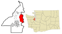
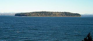
Bainbridge Island is a city and island in Kitsap County, Washington, United States. It is located in Puget Sound. The population was 24,825 at the 2020 census,[6] making Bainbridge Island the second largest city in Kitsap County.
For thousands of years,[7] members of the Suquamish people and their ancestors lived on the land now called Bainbridge Island.[8] There were nine villages on the island; these included winter villages at Port Madison, Battle Point, Point White, Lynwood Center, Port Blakely, and Eagle Harbor, as well as summer villages at Manzanita, Fletcher Bay, and Rolling Bay.[7]
In 1792, English explorer Captain George Vancouver spent several days with his ship HMS Discovery anchored off Restoration Point at the southern end of Bainbridge Island while boat parties surveyed other parts of Puget Sound. Vancouver spent a day exploring Rich Passage, Port Orchard, and Sinclair Inlet. He failed to find Agate Passage, and so his maps show Bainbridge Island as a peninsula. Vancouver named Restoration Point on May 29, the anniversary of the English Restoration, in honor of King Charles II.[9]
In 1841, US Navy Lieutenant Charles Wilkes visited the island while surveying the Pacific Northwest. Lt. Wilkes named the island after Commodore William Bainbridge, commander of the frigateUSS Constitution in the War of 1812. Settlers originally used Bainbridge Island as a center for the logging and shipbuilding industries with the island being clearcut at least two times in its history.[10] The island was known for huge and accessible cedars, which were especially in demand for ships' masts. The original county seat of Kitsap County was at Port Madison on the island's north end.
In 1855, the Suquamish tribe relinquished their claim to Bainbridge Island by signing the Point Elliott Treaty.[11] The Suquamish agreed to cede all of their territory (which included Bainbridge Island) to the United States in exchange for a reservation at Port Madison and fishing rights to Puget Sound.[11]
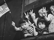
A group of Japanese-American residents of Bainbridge Island wave the American flag and give the victory sign as they are forcibly sent to an internment camp, March 30, 1942.
The first generation of Japanese immigrants, the Issei, came in 1883. During World War II, Japanese-American residents of Bainbridge Island were the first to be sent to internment camps, an event commemorated by the Bainbridge Island Japanese American Exclusion Memorial, which opened in 2011.[12][13] They were held by the US government through the duration of the war for fear of espionage. A High-frequency direction finding (HFDF) station was established here by the Navy during the war. These radio intercept sites along the West Coast were used to track Japanese warships and merchant marine vessels as far away as the Western Pacific. The other West Coast stations were in California at Point Arguello, Point Saint George, Farallon Islands and San Diego.[14]
The city has occupied the entire space of Bainbridge Island since February 28, 1991, when the 1.5-square-mile (3.9km2) city of Winslow (incorporated on August 9, 1947), annexed the rest of the island[16][17] after a narrowly passed November 1990 referendum.[18] It officially remained the city of Winslow for several months, until November 7, 1991 at which time the city of Winslow was renamed the city of Bainbridge Island.[18]
Geography
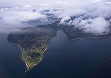
Aerial view of the northern part of Bainbridge Island adjoining Puget Sound, with Agate Passage in center, Liberty Bay on the Kitsap Peninsula in the background, and the Hood Canal beyondAerial view of Bainbridge Island from the southeast, showing the Bainbridge Island ferry from Seattle making the first of two turns to bring it into Eagle Harbor, with Blakely Harbor to its left
Bainbridge Island was formed during the last ice age—13,000 to 15,000 years ago—when the 3,000-foot-thick (910m) Vashon Glacier scraped out the Puget Sound and Hood Canal basins.
Bainbridge Island is in the Puget Sound Basin, east of the Kitsap Peninsula, directly east of the Manette Peninsula and west of Seattle. The island is about 5 miles (8km) wide and 10 miles (16km) long, encompassing nearly 17,778 acres (27.778sqmi; 71.95km2), and is one of Puget Sound's larger islands.[19]
Bainbridge Island shorelines border the main body of Puget Sound, as well as Port Orchard Bay, a large protected embayment, and two high-current tidal passages, Rich Passage and Agate Pass. The island has an irregular coastline of approximately 53 miles (85km), with numerous bays and inlets and a significant diversity of other coastal land forms, including spits, bluffs, dunes, lagoons, cuspate forelands, tombolos, tide flats, streams and tidal deltas, islands, and rocky outcrops. The high point is 425-foot (130m)Toe Jam Hill.[20]
On the Kitsap Peninsula, Bremerton and Poulsbo lie across the Port Orchard channel to the west, and the city of Port Orchard lies across Rich Passage to the south. Despite the short distance over water and significant commuting population between Bremerton and Bainbridge Island, proposals to construct a bridge have been resisted on the Bainbridge side for various reasons.[21]
The island is quite hilly and hosts the Chilly Hilly bicycle ride every February.
The ferry Wenatchee en route from Seattle to Bainbridge Island
Bainbridge Island can be accessed by motor vehicle, bicycle, or foot through two access points, both on Washington State Route 305. Bainbridge Island is connected to the Kitsap Peninsula by the Agate Pass Bridge, carrying SR 305 over Agate Passage at the island's northwest corner. The only other way off the island is by the Seattle–Bainbridge Island ferry, the Washington State Ferries service from the dock at Winslow in Eagle Harbor to Colman Dock (Pier 52) in Seattle. Numerous public right of way access points to water around the island also exist, officially called Road Ends.[22]
When the city of Winslow annexed the entirety of Bainbridge Island in 1991, it absorbed numerous named unincorporated communities. Most of these are still referred to by name.
According to a 2007 estimate, the median income for a household in the city was $88,243, and the median income for a family was $108,605. Males had a median income of $65,853 versus $42,051 for females. The per capita income for the city was $37,482. About 3.0% of families and 4.4% of the population were below the poverty line, including 3.8% of those under age 18 and 3.3% of those age 65 or over.
The socioeconomic profile varies significantly between the rural parts of the island and Winslow, its urban center. In contrast to Bainbridge Island as a whole, Winslow is home to households with a wide range of incomes. In 2010, the census block group in which Winslow is located had a median household income of $42,000, less than half of the island's median household income and one-third of several of the island's wealthiest block groups, and also $10,000 less than national and statewide averages. More than half of Winslow households live in rental units, compared to 20% of households across the island.
2010 census
As of the 2010 census,[24] there were 23,025 people, 9,470 households, and 6,611 families residing in the city. The population density was 833.9 inhabitants per square mile (322.0/km2). There were 10,584 housing units at an average density of 383.3 per square mile (148.0/km2). The racial makeup of the city was 91.0% White, 0.4% African American, 0.5% Native American, 3.2% Asian, 0.2% Pacific Islander, 0.7% from other races, and 3.9% from two or more races. Hispanic or Latino of any race were 3.9% of the population.
There were 9,470 households, of which 31.9% had children under the age of 18 living with them, 60.2% were married couples living together, 7.1% had a female householder with no husband present, 2.6% had a male householder with no wife present, and 30.2% were non-families. 25.1% of all households were made up of individuals, and 10.6% had someone living alone who was 65 years of age or older. The average household size was 2.41 and the average family size was 2.88.
The median age in the city was 47.7 years. 23.7% of residents were under the age of 18; 4.1% were between the ages of 18 and 24; 17.5% were from 25 to 44; 38% were from 45 to 64; and 16.4% were 65 years of age or older. The gender makeup of the city was 48.3% male and 51.7% female.
2000 census
Panoramic view of Eagle Harbor from the Harbour Public House. The bridge in the foreground is part of the Harbour Marina, while the boats are in the Winslow Wharf Marina.
As of the census of 2000, there were 20,308 people, 7,979 households, and 5,784 families residing in the city. The population density was 735.6 inhabitants per square mile (284.0/km2). There were 8,517 housing units at an average density of 308.5 per square mile (119.1/km2). The racial makeup of the city was 92.88% White, 0.28% African American, 0.62% Native American, 2.40% Asian, 0.11% Pacific Islander, 0.75% from other races, and 2.96% from two or more races. Hispanics or Latinos, of any race, were 2.17% of the population.
There were 7,979 households, out of which 36.8% had children under the age of 18 living with them, 63.1% were married couples living together, 7.1% had a female householder with no husband present, and 27.5% were non-families. 22.6% of all households were made up of individuals, and 9.1% had someone living alone who was 65 years of age or older. The average household size was 2.52 and the average family size was 2.98.
In the city, the population was spread out, with 26.7% under the age of 18, 3.6% from 18 to 24, 23.8% from 25 to 44, 33.1% from 45 to 64, and 12.8% who were 65 years of age or older. The median age was 43 years. For every 100 females, there were 94.5 males. For every 100 females age 18 and over, there were 90.0 males.
Economy
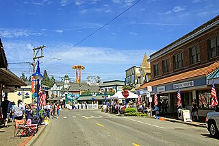
Bainbridge Island has four centers of commerce: Winslow, Lynwood Center, Fletcher Bay (also referred to as Island Center), and Rolling Bay.[25] Winslow is the downtown core and has most of the shopping and dining. Lynwood Center on the south end of the island has several restaurants and a small hotel. Fletcher Bay (also referred to as Island Center) has a small grocery store and one restaurant. Rolling Bay is located on the east side of the island.[citation needed]
Madrona School (Parent/Child, Preschool, Kindergarten, Grades 1-5)
St. Cecilia Catholic School (PK-8)
The Island School (K-5)
Carden Country School (K-8)
Hyla School (6-12)
The Puget Sound Naval Academy, formerly the Moran School, operated on the island from 1914 to 1933, and then again from 1937 to 1951.
Sports and recreation
In 2001, Bainbridge Island Little League were represented in South Williamsport, Pennsylvania at the Little League World Series. The island's high school lacrosse team has won state titles, the most recent coming on May 19, 2007.[28] In 2009, the Bainbridge High School Fastpitch team won the Washington 3A State Title. The team also played in the championship game in 2010. In 2011, 2012 and 2018, the Bainbridge High School Girls Lacrosse team won the state championship.
Pickleball was invented by the family of congressman Joel Pritchard at their summer home on Bainbridge Island in 1965.[29] It is similar to badminton and tennis, but played with paddles and a lightweight plastic ball.[30]
Aerial view of Restoration Point, with the Country Club of Seattle, and Blakely Harbor
Government and politics
Bainbridge Island has a seven-member city council. The members are elected to staggered four-year terms and appoint a city manager.[1]
In the 2008 Democratic primary (which in Washington state was not used for delegate appointment), Barack Obama defeated Hillary Clinton by a margin of 67.8% to 29.7%.[32] This was Obama's second-best performance in an incorporated municipality in the state, behind Yarrow Point. In the earlier caucus, Obama received 79.3% of delegates, Clinton received 19.8%, and 0.1% were uncommitted.[33]
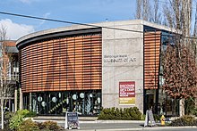
The Bainbridge Island Museum of Art opened in June 2013 near the Winslow ferry terminal. It was developed by Cynthia Sears, who began collecting works of art made by island residents in 1989. The museum cost $15.6million to construct and includes a 99-seat auditorium, a classroom, and other spaces. The building has 20,000 square feet (1,900m2) of space and was designed to resemble the bow of a ship.[34]
The art exhibit "Pia the Peacekeeper" was placed in Bainbridge Island's Sakai park. Pia is #121 of an ongoing art portfolio by Copenhagen-based Thomas Dambo.[35] Dambo specializes in recycled art and is a self-proclaimed climate activist, with the project being entirely made of recycled materials. According to Bainbridge's parks and recreation site, Pia "embodies the essence of community and imagination."[36]
Bainbridge Island is the main setting of the 2021 novel You Love Me, the third installment in the You series by novelist Caroline Kepnes. Kepnes visited Bainbridge while writing the story and used the names of several local businesses.[37]
In Michael Crichton's 1994 novel Disclosure, protagonist Tom Sanders lives with his wife and two children on Bainbridge Island. Some scenes from the film adaptation later that year were filmed on the island, including at Bainbridge Ferry Terminal and Capt. Johnston Blakely Elementary School.
The epilogue of the 1996 film That Thing You Do! reveals that main characters Guy Patterson and Faye Dolan moved with their four children to Bainbridge Island, where they founded the fictional Puget Sound Conservatory of Music.
Seattle-bound cars waiting at Bainbridge Island Ferry Terminal
Notable people
This article's list of residents may not follow Wikipedia's verifiability policy. Please improve this article by removing names that do not have independent reliable sources showing they merit inclusion in this article AND are residents, or by incorporating the relevant publications into the body of the article through appropriate citations.(March 2020)
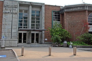
Kitsap County is a county in the U.S. state of Washington. As of the 2020 census, its population was 275,611. Its county seat is Port Orchard; its largest city is Bremerton. The county, formed out of King County and Jefferson County on January 16, 1857, is named for Chief Kitsap of the Suquamish Tribe. Originally named Slaughter County, it was soon renamed.
Indianola is a census-designated place (CDP) in Kitsap County, Washington, United States, located on the north shore of Port Madison on the Port Madison Indian Reservation, home of the Suquamish Indian Tribe. The population was 3,664 at the 2020 census. It was originally established as a summer community and was a stop for Mosquito Fleet ferries until the 1950s.
Manchester is an unincorporated community and census-designated place (CDP) in Kitsap County, Washington, United States. The population was 5,714 at the 2020 census. Manchester is located on the Puget Sound approximately 10 miles from downtown Seattle, and is adjacent to county seat Port Orchard to its east. Today, Manchester labels itself as a village. It is small in size but is home to a Kitsap Regional Library (KRL) branch, a post office, an elementary school, and a beachfront park to serve its residents.
Port Orchard is a city in and the county seat of Kitsap County, Washington, United States. It is located 13 miles (21 km) due west of West Seattle and is connected to Seattle and Vashon Island via the Washington State Ferries run to Southworth. It is named after Port Orchard, the strait that separates Bainbridge Island from the Kitsap Peninsula.
Poulsbo is a city on Liberty Bay in Kitsap County, Washington, United States. It is the smallest of the four cities in Kitsap County. The population was 11,970 at the 2020 census and an estimated 10,927 in 2018.
Suquamish is a census-designated place (CDP) in Kitsap County, Washington, United States. The population was 4,266 at the 2020 census. Comprising the Port Madison Indian Reservation, it is the burial site of Chief Seattle and was the site of the Suquamish tribe winter longhouse known as the Old Man House.
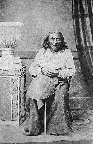
Seattle was a 19th-century leader of the Duwamish and Suquamish peoples. A leading figure among his people, he pursued a path of accommodation to white settlers, forming a personal relationship with "Doc" Maynard. The city of Seattle, in the U.S. state of Washington, was named after him. A widely publicized speech arguing in favor of ecological responsibility and respect of Native Americans' land rights had been attributed to him.
The Suquamish are a Lushootseed-speaking Native American people, located in present-day Washington in the United States. They are a southern Coast Salish people.
Washington State Ferries (WSF) is a government agency that operates automobile and passenger ferry service in the U.S. state of Washington as part of the Washington State Department of Transportation. It runs ten routes serving 20 terminals located around Puget Sound and in the San Juan Islands, designated as part of the state highway system. The agency maintains a fleet of 21 vessels that are able to carry passengers and vehicles.
Winslow is the name of the downtown area of the city of Bainbridge Island, Washington, and is the original name of the city, named for shipbuilder Winslow Hall. It encompasses the area around the main street, Winslow Way, and is made up of approximately 1.5 square miles (3.9 km2) overlooking Eagle Harbor.
The Kitsap Peninsula lies west of Seattle across Puget Sound, in Washington state in the Pacific Northwest. Hood Canal separates the peninsula from the Olympic Peninsula on its west side. The peninsula, a.k.a. "Kitsap", encompasses all of Kitsap County except Bainbridge and Blake Islands, as well as the northeastern part of Mason County and the northwestern part of Pierce County. The highest point on the Kitsap Peninsula is Gold Mountain. The U.S. Navy's Puget Sound Naval Shipyard, and Naval Base Kitsap are on the peninsula. Its main city is Bremerton.
Blake Island is a Puget Sound island in Kitsap County, Washington, United States, that is preserved as Blake Island Marine State Park. The island lies north of Vashon Island, south of Bainbridge Island, and east of Manchester. On the northeast end of the island is Tillicum Village, a tourist attraction based on Northwest Coast Indian arts, culture, and food. The park is managed by the Washington State Parks and Recreation Commission.
Port Madison, sometimes called Port Madison Bay, is a deep water bay located on the west shore of Puget Sound in western Washington. It is bounded on the north by Indianola, on the west by Suquamish, and on the south by Bainbridge Island. Port Madison connects to Bainbridge Island via the Agate Pass Bridge to the southwest. Two small bays open off Port Madison: Miller Bay to the northwest, and another small bay to the south which, confusingly, is also called Port Madison Bay.
The Suquamish Indian Tribe of the Port Madison Reservation is a federally recognized tribe and Indian reservation in the U.S. state of Washington.
Agate Pass or Agate Passage is a high-current tidal strait in Puget Sound connecting Port Madison and mainland Kitsap County in the US state of Washington. It lies between Bainbridge Island and the mainland of the Kitsap Peninsula near Suquamish. It leads south towards Bremerton, extending about one mile (1.6 km) in a straight, southwesterly direction. The depth is about 20 feet (6.1 m). The shores are wooded and fairly steep. The shoreline is mostly rocky and fringed with kelp to Point Bolin. The tidal currents have velocities up to six knots; the flood tide sets southwesterly, and the ebb tide northeasterly.
The Agate Pass Bridge is a structural steel truss cantilever bridge spanning Agate Pass, connecting Bainbridge Island to the Kitsap Peninsula. It was built in 1950, and it replaced a car ferry service which dated from the 1920s. The bridge provides a direct route along Washington State Route 305 between Seattle, via the Seattle-Bainbridge Island ferry, and the Kitsap Peninsula.
The M/V Kitsap was a ferry built in 1925 at the Lake Washington Shipyard in Houghton, Washington. She was 165 feet (50 m) long, and her original capacity in 1925 was 95 cars and approximately 800 passengers. By 1960, cars had become much bigger and her capacity was reduced to 32 modern automobiles and 325 passengers. A 600-horsepower Estep diesel engine allowed her to sail at 12 knots when originally built. Almost every part of her was from Washington state; her hull and superstructure were built from Washington-grown fir, and her Estep engine was built in at Washington Iron Works in Tacoma.
State Route 305 (SR 305) is a 13.50-mile-long (21.73 km) state highway in the U.S. state of Washington, primarily serving Bainbridge Island in Kitsap County and connecting it to Seattle in King County via the Seattle–Bainbridge Island ferry. The highway travels north through Bainbridge Island and leaves the island on the Agate Pass Bridge into the Kitsap Peninsula. SR 305 continues northwest through Poulsbo, intersecting SR 307 and ending at the SR 3 freeway. The highway was created during the 1964 highway renumbering and was preceded by Secondary State Highway 21A (SSH 21A), established in 1937. The ferry, part of the highway since 1994, is served by the Jumbo Mark-II-classMV Tacoma and MV Wenatchee and operates on a 35-minute crossing time.
The Kitsap County Transportation Company was an important steamboat and ferry company that operated on Puget Sound. The company was founded in 1898 as the Hansen Transportation Company.
The Seattle–Bainbridge ferry is a ferry route across Puget Sound between Seattle and Bainbridge Island, Washington. The route was called the Seattle–Winslow ferry before the city of Winslow annexed the rest of the island and changed its name. Since 1951 the only ferries employed on the route have belonged to the Washington state ferry system, currently the largest ferry system in the United States.
↑ Miller, Jay; Ruby, Robert H.; Brown, John A. (April 1987). "A Guide to the Indian Tribes of the Pacific Northwest". The Western Historical Quarterly. 18 (2): 205. doi:10.2307/969592. ISSN0043-3810. JSTOR969592.
↑ Roberts, John E. (2005). A Discovery Journal: George Vancouver's First Survey Season - 1792. Trafford Publishing. pp.57–60, 67. ISBN978-1-4120-7097-3.
↑ Nelson, Glenn (August 21, 2016). "As National Park Service turns 100, Seattle ranger personifies change". The Seattle Times. Retrieved November 22, 2017. ...the Japanese American Exclusion Memorial, built, maintained and supported by several community groups on Bainbridge Island. It gains its imprimatur as a satellite of the Park Service's Minidoka National Historic Site in Idaho. The Park Service owns none of the Bainbridge property, but Beall (superintendent of Seattle's National Park units) kicks in $14,000 for a seasonal ranger.
↑ Menzel, Sewall (2020). The Pearl Harbor Secret: Why Roosevelt Undermined the U.S. Navy. ABC-CLIO. p.41. ISBN9781440875861.
↑ William Yardley, "For Lawyer in Afghan Killings, the Latest in a Series of Challenging Defenses," The New York Times (March 25, 2012).
↑ "Dove Cameron - Synchronicity One". YouTube. Archived from the original on December 11, 2021. Retrieved March 26, 2021. I was born in, I always say Seattle, Washington, but that's just because nobody knows where the fuck I'm from, which is a small island next to Seattle, called Bainbridge Island.
↑ Michael Trimble, tenor. Trimble Vocal Institute.: The Trimble Vocal Institute is thriving on Bainbridge Island, Washington in the beautiful Pacific Northwest where Michael Trimble and his wife, Cantor Pamela Trimble, relocated in May 2001.
This page is based on this Wikipedia article Text is available under the CC BY-SA 4.0 license; additional terms may apply. Images, videos and audio are available under their respective licenses.