Boundary Channel

Last updated
Boundary Channel
Boundary Channel - Potomac River - US Coastal Pilot 2013.jpg
Map of area surrounding Boundary Channel and the Pentagon Lagoon
Location
CountryUnited States
StateDistrict of Columbia
Physical characteristics
SourcePotomac River
  coordinates 38°53′24.4″N77°3′49.3″W / 38.890111°N 77.063694°W / 38.890111; -77.063694
  elevation0 ft (0 m)
Mouth Pentagon Lagoon
  coordinates
38°52′26″N77°2′53″W / 38.87389°N 77.04806°W / 38.87389; -77.04806 Coordinates: 38°52′26″N77°2′53″W / 38.87389°N 77.04806°W / 38.87389; -77.04806
  elevation
0 ft (0 m)
Basin features
River system Potomac River

Boundary Channel is a channel off the Potomac River in Washington, D.C. The channel begins at the northwestern tip of Columbia Island extends southward between Columbia Island and the Virginia shoreline. It curves around the southern tip of Columbia Island before heading northeast to exit into the Potomac River. At the southwestern tip of Columbia Island, the Boundary Channel widens into the manmade Pentagon Lagoon.

Contents

History of Boundary Channel

Columbia Island is in part natural, and in part man-made. About 1818, Analostan Island (now known as Theodore Roosevelt Island) was largely rock and quite close to the D.C. shoreline. Due to deforestation and increased agricultural use upstream, the river eroded much of the northern bank of the Potomac River and widened the gap between Analostan Island and the shore. Simultaneously, large deposits of silt built up around Analostan Island. By 1838, Analostan had almost doubled in length toward the south. By 1884, the new southern part of Analostan Island was defined and built up, and supported a well-established wetland. Gradually, however, the river eroded the center of Analostan Island, severing Columbia Island from its parent body. [1]

Between 1911 and 1922, the Potomac River was repeatedly dredged by the United States Army Corps of Engineers to deepen the channel and alleviate flooding. Dredging widened the distance between Analostan/Theodore Roosevelt Island and Columbia Island (so that the "Virginia Channel" west of Analostan/Roosevelt Island would not flood easily). Dredged material was piled high on Columbia Island, helping to build it higher, lengthen and broaden it, and give it its current shape. [1] The new island received its name about 1918 from an unnamed engineer working for the District of Columbia. [2]

An anonymous Corps of Engineers officer named the waterway between Columbia Island and Virginia the "Boundary Channel". [3]

Boundary Channel was further defined in the late 1920s. In 1925, Congress authorized construction of the Arlington Memorial Bridge across the Potomac River. Preliminary designs for the bridge showed it terminating on Columbia Island, [4] which necessitated additional expansion of the island. The Corps of Engineers had already planned to continue dredging the Potomac River and enlarge Columbia Island, so on April 1, 1925, Secretary of War John W. Weeks ordered the expenditure of $114,500 to dredge the river between the Highway Bridge and the Lincoln Memorial. The dredged material was dumped on Columbia Island. [5] By June 30, 1927, dredging of the Potomac River and the reshaping of Columbia Island was largely finished. [6]

Boundary Channel marks the original Virginia shoreline. [7] It separates Columbia Island to the east from Virginia in the west and south, and is roughly a mile long. The channel is part of the Potomac River. [8] In 1936, Boundary Channel was 100 to 200 feet (30 to 61 m) in width and 4 to 6 feet (1.2 to 1.8 m) in depth. [9] No lagoon existed at this time.

Broundary Channel was changed again after ground was broken for The Pentagon on September 11, 1941. The Pentagon was being built on land just south of the Boundary Channel. But the ground to the northwest, north, northeast, and east of the building site was so low that, for a time, the Corps of Engineers considered building a levee to protect it from floods. But General Brehon B. Somervell, the Army officer in charge of the Pentagon's construction, decided instead to raise the ground by at least 8 feet (2.4 m) to 18 feet (5.5 m) or more above the average water level. Boundary Channel was dredged and slightly widened in order to help provide this fill material. [10]

Due to silting and other issues, Boundary Channel is approximately 100 feet (30 m) wide as of 2013 (although the width varies). It is also quite shallow. [11]

Pentagon Lagoon

Aerial view of the Columbia Island Marina and the Pentagon Lagoon in relationship to The Pentagon and the Potomac River. The Pentagon US Department of Defense building.jpg
Aerial view of the Columbia Island Marina and the Pentagon Lagoon in relationship to The Pentagon and the Potomac River.
Corona image of The Pentagon and part of the Lagoon, 25 September 1967 Corona pentagon.jpg
Corona image of The Pentagon and part of the Lagoon, 25 September 1967

Pentagon Lagoon is a shallow pool which is part of the Boundary Channel. [12] It was originally constructed as part of the channel, and was originally quite small as well as unnamed. [10]

During construction of the Pentagon in 1941, the U.S. Army not only needed a source of fill material to raise the land around the Pentagon, but also needed a way for river barges to deliver concrete, gravel, and sand to the construction site. With unused Columbia Island nearby, the Corps of Engineers quickly removed a portion of the island as well as dredged the bottom of the lagoon for this fill material. The Army also constructed a dike inland on the Virginia shoreline. The earth behind this dike was excavated to a depth 14 feet (4.3 m) below the Potomac River's average high tide. On what was to be the new shoreline, the Army and its contractors built cement plants and marshalling areas for the deposit of sand and gravel. The dike was then breached (and removed by dredge), allowing barges and other ships to deliver construction materials quickly and cheaply to the building site. More than 1,000,000 cubic yards (760,000 m3) of earth and riverbottom were excavated, and Boundary Channel's lagoon enlarged by 30 acres (120,000 m2). [10]

The Pentagon Lagoon was named by The Washington Post after a brutal murder there in September 1944. Virginia police found the nude body of 53-year-old Mrs. Margaret Fitzwater floating in the lagoon on the evening of September 24, 1944. Her throat had been slashed, and she had been raped. Within days, 60-year-old Gardner Tyler "Pop" Holmes, an eccentric who lived on a houseboat anchored in the lagoon, was charged with her murder. It quickly became apparent that Holmes was insane (and had, in fact, escaped from a Virginia mental hospital in 1931). [13] The phrase "Pentagon lagoon" was first used by the federal government in 1945, [14] but the formal name "Pentagon Lagoon" was not used until 1946. [15]

When the Pentagon Lagoon was surveyed in 2000, the eastern entrance channel was 7.5 feet (2.3 m) deep. Depths of 5 to 8 feet (1.5 to 2.4 m) were common in front of the Columbia Island Marina, while 2 to 7 feet (0.61 to 2.13 m) was common elsewhere in the lagoon. [11]

Crossings

The following bridges cross Boundary Channel, listed from south to north:

ImageCrossingOpenedCoordinatesNotes
George Washington Parkway Boundary Channel Bridge 2019.jpg George Washington Memorial Parkway
Mount Vernon Trail
1932 [16] 38°52′31″N77°02′50″W / 38.8754°N 77.0471°W / 38.8754; -77.0471 Known as Humpback Bridge; widened and pedestrian underpasses added in 2010 [17]
Lyndon Johnson Grove footbridge 2020.jpg Footbridge to Lyndon Baines Johnson Memorial Grove 38°52′44″N77°03′11″W / 38.8789°N 77.0530°W / 38.8789; -77.0530
Washington Boulevard Boundary Channel crossing 2020.jpg Virginia 27.svg SR 27 ( Washington Boulevard )1942 [18] 38°52′49″N77°03′26″W / 38.8804°N 77.0573°W / 38.8804; -77.0573
George Washington Parkway southbound Boundary Channel crossing 2020b.jpg George Washington Memorial Parkway southbound 38°52′51″N77°03′32″W / 38.88085°N 77.0589°W / 38.88085; -77.0589
EASTERN VIEW OF WATERGATE AT CENTER AND THE ROCK CREEK AND POTOMAC PARKWAY RAMP AT LEFT. VIEW TAKEN FROM NORTHERN RAILING OF MEMORIAL BRIDGE. - Arlington Memorial Bridge, Boundary HAER DC,WASH,563-B-2.tif Memorial Avenue 1932 [19] 38°53′06″N77°03′42″W / 38.8851°N 77.0616°W / 38.8851; -77.0616
Arlington Boulevard Boundary Channel crossing 2020a.jpg Arlington Boulevard 1949 [20] 38°53′20″N77°03′51″W / 38.8889°N 77.0641°W / 38.8889; -77.0641 replaced wooden bridge opened in 1938 [21]
George Washington Parkway northbound Boundary Channel crossing 2020.jpg George Washington Memorial Parkway northbound 38°53′24″N77°03′51″W / 38.8899°N 77.0641°W / 38.8899; -77.0641
Mount Vernon Trail 38°53′24″N77°03′50″W / 38.88995°N 77.0640°W / 38.88995; -77.0640

Related Research Articles

<span class="mw-page-title-main">Potomac River</span> River in the Mid-Atlantic United States

The Potomac River is a major river in the Mid-Atlantic region of the United States that flows from the Potomac Highlands in West Virginia to the Chesapeake Bay in Maryland. It is 405 miles (652 km) long, with a drainage area of 14,700 square miles (38,000 km2), and is the fourth-largest river along the East Coast of the United States and the 21st-largest in the United States. Over 5 million people live within its watershed.

<span class="mw-page-title-main">Arlington Memorial Bridge</span> Bridge in Washington, D.C.

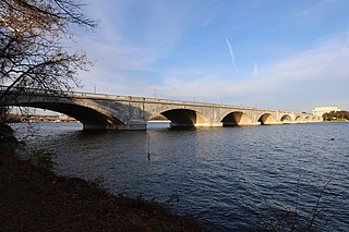
The Arlington Memorial Bridge is a Neoclassical masonry, steel, and stone arch bridge with a central bascule that crosses the Potomac River at Washington, D.C., the capital of the United States. First proposed in 1886, the bridge went unbuilt for decades thanks to political quarrels over whether the bridge should be a memorial, and to whom or what. Traffic problems associated with the dedication of the Tomb of the Unknown Soldier in November 1921 and the desire to build a bridge in time for the bicentennial of the birth of George Washington led to its construction in 1932.

<span class="mw-page-title-main">Woodrow Wilson Bridge</span> Bascule bridge over the Potomac River

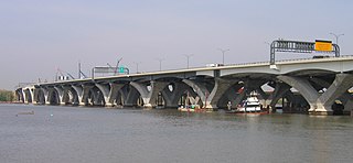
The Woodrow Wilson Memorial Bridge, also known as the Woodrow Wilson Bridge or the Wilson Bridge, is a bascule bridge that spans the Potomac River between Alexandria, Virginia and Oxon Hill, Maryland in Prince George's County, Maryland. The original bridge was one of only a handful of drawbridges in the Interstate Highway System. It contained the only portion of the Interstate System owned and operated by the federal government until construction was completed and it was turned over to the Virginia and Maryland departments of transportation.

<span class="mw-page-title-main">Theodore Roosevelt Island</span> Island and memorial in the Potomac River, Washington, D.C., U.S.

Theodore Roosevelt Island is an 88.5-acre (358,000 m2) island and national memorial located in the Potomac River in Washington, D.C. During the Civil War, it was used as a training camp for the United States Colored Troops. The island was given to the federal government by the Theodore Roosevelt Association in memory of the 26th president, Theodore Roosevelt. Until then, the island had been known as My Lord's Island, Barbadoes Island, Mason's Island, Analostan Island, and Anacostine Island.

<span class="mw-page-title-main">Theodore Roosevelt Bridge</span> Bridge in D.C. and the Rosslyn section of Arlington, Virginia

The Theodore Roosevelt Bridge is a bridge crossing the Potomac River which connects Washington, D.C., with the Commonwealth of Virginia. The bridge crosses over Theodore Roosevelt Island, and carries Interstate 66/U.S. Route 50. The center lane in the bridge is reversible; the middle barrier is moved with a barrier transfer machine. It's operated eastbound during the morning rush hour from 6-11 am. The bridge is named in honor of Theodore Roosevelt, the 26th President of the United States.

<span class="mw-page-title-main">Key Bridge (Washington, D.C.)</span> United States historic place

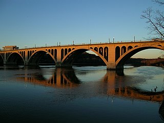
The Francis Scott Key Bridge, more commonly known as the Key Bridge, is a six-lane reinforced concrete arch bridge conveying U.S. Route 29 (US 29) traffic across the Potomac River between the Rosslyn neighborhood of Arlington County, Virginia, and the Georgetown neighborhood of Washington, D.C. Completed in 1923, it is Washington's oldest surviving road bridge across the Potomac River.

<span class="mw-page-title-main">Constitution Avenue</span> Street in the city of Washington, D.C.

Constitution Avenue is a major east–west street in the northwest and northeast quadrants of the city of Washington, D.C., in the United States. It was originally known as B Street, and its western section was greatly lengthened and widened between 1925 and 1933. It received its current name on February 26, 1931, though it was almost named Jefferson Avenue in honor of Thomas Jefferson.

<span class="mw-page-title-main">Columbia Island (Washington, D.C.)</span> Island in Washington, D.C.

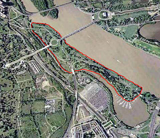
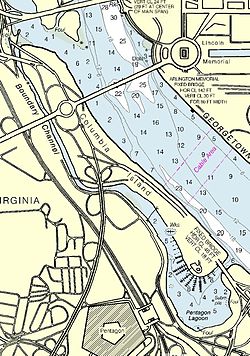
Lady Bird Johnson Park, formerly known as Columbia Island until 1968, is an island located in the Potomac River in Washington, D.C., in the United States. It formed naturally as an extension of Analostan Island in the latter part of the 1800s, and over time erosion and flooding severed it from Analostan, now known as Theodore Roosevelt Island. The U.S. federal government deposited material dredged from the Potomac River on the island between 1911 and 1922, and again from 1925 to 1927. The island was also reshaped by the government at this time "to serve as the western terminus of Arlington Memorial Bridge and a symbolic entrance into the nation’s capital." Located within the park are the Lyndon Baines Johnson Memorial Grove, Navy – Merchant Marine Memorial, and the Columbia Island Marina. The island, park, memorials, and marina are part of the George Washington Memorial Parkway and administered by the National Park Service.

<span class="mw-page-title-main">Three Sisters (District of Columbia)</span> Rocky islands in the Potomac River in Washington, D.C.

The Three Sisters are three rocky islands in the Potomac River in Washington, D.C., west of the Key Bridge. A notable landmark in colonial times, the islets are less well known as the Three Sisters Islands and Three Sisters Island.

<span class="mw-page-title-main">Independence Avenue (Washington, D.C.)</span>

Independence Avenue is a major east-west street in the southwest and southeast quadrants of the city of Washington, D.C., in the United States, running just south of the United States Capitol. Originally named South B Street, Independence Avenue SW was constructed between 1791 and 1823. Independence Avenue SE was constructed in pieces as residential development occurred east of the United States Capitol and east of the Anacostia River. Independence Avenue SW received its current name after Congress renamed the street in legislation approved on April 13, 1934. Independence Avenue SW originally had its western terminus at 14th Street SW, but was extended west to Ohio Drive SW between 1941 and 1942. The government of the District of Columbia renamed the portion of the road in the southeast quadrant of the city in 1950.

<span class="mw-page-title-main">East Potomac Park</span> Park in the Potomac River, Washington, D.C., U.S.

East Potomac Park is a park located on a man-made island in the Potomac River in Washington, D.C., United States. The island is between the Washington Channel and the Potomac River, and on it the park lies southeast of the Jefferson Memorial and the 14th Street Bridge. Amenities in East Potomac Park include the East Potomac Park Golf Course, a miniature golf course, a public swimming pool, tennis courts, and several athletic fields. The park is a popular spot for fishing, and cyclists, walkers, inline skaters, and runners heavily use the park's roads and paths. A portion of Ohio Drive SW runs along the perimeter of the park.

<span class="mw-page-title-main">Aqueduct Bridge (Potomac River)</span> Bridge between Georgetown, Washington, D.C., and Rosslyn, Virginia

The Aqueduct Bridge was a bridge between Georgetown, Washington, D.C., and Rosslyn, Virginia. It was built to transport cargo-carrying boats on the Chesapeake and Ohio Canal in Georgetown across the Potomac River to the Alexandria Canal. The same eight piers supported two different bridges: a wooden canal bridge and an iron truss bridge carrying a roadway and an electric trolley line. The bridge was closed in 1923 after the construction of the nearby Key Bridge. The shuttered Aqueduct Bridge was demolished in 1933 though its arched, stone abutment on the Georgetown (north) end is still present and overseen by the National Park Service as an historic site.

<span class="mw-page-title-main">Kingman Island</span>

Kingman Island and Heritage Island are islands in Northeast and Southeast Washington, D.C., in the Anacostia River. Both islands are man-made, built from material dredged from the Anacostia River and completed in 1916. Kingman Island is bordered on the east by the Anacostia River, and on the west by 110-acre (45 ha) Kingman Lake. Heritage Island is surrounded by Kingman Lake. Both islands were federally owned property managed by the National Park Service until 1995. They are currently owned by the D.C. government, and managed by Living Classrooms National Capital Region. Kingman Island is bisected by Benning Road and the Ethel Kennedy Bridge, with the southern half of the island bisected again by East Capitol Street and the Whitney Young Memorial Bridge. As of 2010, Langston Golf Course occupied the northern half of Kingman Island, while the southern half of Kingman Island and all of Heritage Island remained largely undeveloped. Kingman Island, Kingman Lake and nearby Kingman Park are named after Brigadier General Dan Christie Kingman, the former head of the United States Army Corps of Engineers.

<span class="mw-page-title-main">Kingman Lake</span> Body of water

Kingman Lake is a 110-acre (0.45 km2) artificial lake located in the Anacostia River in Washington, D.C., in the United States. The lake was created in 1920 when the United States Army Corps of Engineers used material dredged from the Anacostia River to create Kingman Island. The Corps of Engineers largely blocked the flow of the Anacostia River to the west of Kingman Island, creating the lake. Kingman Lake is currently managed by the National Park Service.

<span class="mw-page-title-main">Greenway (Washington, D.C.)</span> Neighborhood in Ward 7, United States

Greenway is a residential neighborhood in Southeast Washington, D.C., in the United States. The neighborhood is bounded by East Capitol Street to the north, Pennsylvania Avenue SE to the south, Interstate 295 to the west, and Minnesota Avenue to the east.

<span class="mw-page-title-main">Amtrak Railroad Anacostia Bridge</span> Railway-only bridge across the Anacostia River in Washington, D.C.

The Amtrak Railroad Anacostia Bridge is a railway bridge that crosses the Anacostia River in Washington, D.C. It carries Amtrak's Northeast Corridor and MARC's Penn Line passenger rail traffic. The bridge was damaged by the 1933 Chesapeake–Potomac hurricane, causing the famous "Crescent Limited wreck".

<span class="mw-page-title-main">Three Sisters Bridge</span>

The Three Sisters Bridge was a planned bridge over the Potomac River in Washington, D.C., with piers on the Three Sisters islets. Envisioned in the 1950s and formally proposed in the 1960s, it was cancelled amid protests in the 1970s.

The construction of the Virginia approaches to Arlington Memorial Bridge was a 16-year road construction project to connect Arlington Memorial Bridge with roads in Arlington County, Virginia, in the United States. Initial design proposals were made in 1926, but extensive political wrangling and indecision delayed the project and even the new bridge itself, which finally opened in 1932 after a connection to the Arlington National Cemetery was made via Memorial Drive.

<span class="mw-page-title-main">Construction of Arlington Memorial Bridge</span> United States historic place

The construction of Arlington Memorial Bridge was a seven-year construction project in Washington, D.C., in the United States to construct the Arlington Memorial Bridge across the Potomac River. The bridge was authorized by Congress in February 1925, and was completed in January 1932. As a memorial, its decorative features were extensive and intricate, and resolving the design issues over these details took many years. Tall columns and pylons topped by statuary, Greek Revival temple-like structures, and statue groups were proposed for the ends of the bridge. Carvings and inscriptions were planned for the sides of the bridge, and extensive statuary for the bridge piers.

USAV <i>Essayons</i> (1949 ship) US Army dredge

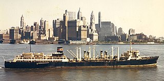
USAVEssayons was a hopper dredge of the United States Army Corps of Engineers. At the time of her construction, she was the largest hopper dredge ever built. She was the flagship of the Army Corps of Engineers dredge fleet. Her primary mission was to maintain the entrance to New York Harbor and other East Coast ports, but she was employed all around the United States and at several international locations. She was launched in 1949 and retired in 1980.

References

  1. 1 2 Office of Conservation, Interpretation, and Use, p. 48-49; Moore and Jackson, p. 91.
  2. Secrest, Meryle. "Park Named for Mrs. Johnson." The Washington Post. November 13, 1968.
  3. Corps of Engineers, p. 533. Accessed 2013-05-07.
  4. "Island to Be Remade in New Bridge Plans." The Washington Post. April 15, 1925.
  5. "Potomac Channel to Be Dredged for Flood Prevention." The Washington Post. April 2, 1925.
  6. Office of Public Buildings and Public Parks of the National Capital, 1927, p. 20.
  7. Moore, p. 91.
  8. "Oil Is Spilled Into Channel From Ft. Myer." The Washington Post. June 14, 1977.
  9. Severin v. United States, 86 Ct. Cl. 53, 56 (1937).
  10. 1 2 3 Vogel, p. 133.
  11. 1 2 National Oceanic and Atmospheric Administration. United States Coast Pilot. Vol. 3: Atlantic Coast: Sandy Hook, NJ to Cape Henry, VA. 46th ed. Washington, D.C.: u.S. Government Printing Office, 2013, p. 291. Accessed 2013-05-07.
  12. Ackerman, Stephen J. and Burton, Jon C. "Catch a Train, Catch a Fish." The Washington Post. July 22, 1983.
  13. Towe, Emily. "FBI Takes Over in Throat-Slashing Mystery of Widow Taken From Lagoon." The Washington Post. September 25, 1944, p. 1; Towe, Emily. "Secret Device Used in Murder Weapon Hunt." The Washington Post. September 26, 1944, p. 1; "7-Hour Lagoon Search Fails to Produce Slaying Weapon." The Washington Post. September 27, 1944, p. 3; "FBI Questions Six Relatives of Slain Woman." The Washington Post. September 30, 1944, p. 7; "'Voluntary Witness' Charged With Pentagon Lagoon Murder." The Washington Post. October 1, 1944, p. 1; "Holmes Sanity Test May Balk Murder Trial." The Washington Post. October 2, 1944, p. 7.
  14. Committee on Interstate and Foreign Commerce, p. 7.
  15. Subcommittee on Appropriations, p. 147.
  16. "Boundary Channel Bridge, Spanning Boundary Channel, Washington, District of Columbia, DC". Historic American Engineering Record. Retrieved 2020-12-24.
  17. Berman, Mark (2007-11-22). "Overhaul of GW Parkway Bridge to Hamper Commute". The Washington Post . ISSN   0190-8286 . Retrieved 2020-12-24.
  18. "Pentagon Roadways Named". The Evening Star. 17 December 1943.
  19. "Arlington Memorial Bridge, Boundary Channel Extension, Spanning Mount Vernon Memorial Highway & Boundary Channel, Washington, District of Columbia, DC". Historic American Engineering Record. Retrieved 2020-12-24.
  20. "D.C.-Virginia Traffic Eased as Two Projects are Put Into Operation". The Evening Star. 20 September 1949.
  21. "Legal Matters Delay Opening of Bridge Link." Washington Post. October 19, 1938.

Bibliography