Tidal Basin

Last updated
Tidal Basin
Tidal Basin Glow.jpg
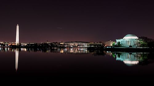
The Tidal Basin (foreground), the Washington Monument (on left) and the Jefferson Memorial (on right), July 2016
USA District of Columbia location map.svg
Red pog.svg
Tidal Basin
Location West Potomac Park, Washington, D.C., U.S.
Coordinates 38°53′03″N77°02′21″W / 38.88417°N 77.03917°W / 38.88417; -77.03917 (Tidal Basin (District of Columbia))
Type Artificial
Primary inflows Potomac River
38°52′49″N77°02′25″W / 38.88028°N 77.04028°W / 38.88028; -77.04028 (Tidal Basin (District of Columbia) Inlet Gate)
Primary outflows Washington Channel
38°52′58″N77°01′59″W / 38.88278°N 77.03306°W / 38.88278; -77.03306 (Tidal Basin (District of Columbia) Outlet Gate)
Basin  countriesUnited States
Surface area107 acres (0.43 km2)
Average depth10 feet (3.0 m)
Surface elevation3 feet (0.91 m)
References "Tidal Basin". Geographic Names Information System . United States Geological Survey, United States Department of the Interior.

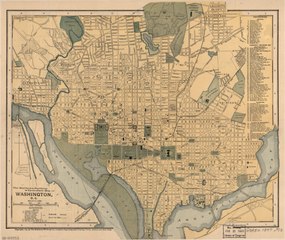
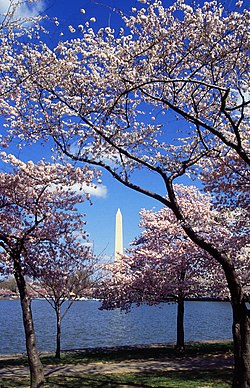
The Tidal Basin is a man-made reservoir located between the Potomac River and the Washington Channel in Washington, D.C. The Basin is part of West Potomac Park, is near the National Mall and is a focal point of the National Cherry Blossom Festival held each spring. The nearby Jefferson Memorial, Martin Luther King Jr. Memorial and Franklin Delano Roosevelt Memorial overlook the Basin, which is south of the Washington Monument.

Contents

History

The concept of the Tidal Basin originated in the 1870s to serve both as a visual centerpiece and as a means for flushing the Washington Channel, a harbor separated from the Potomac River by landfills where East Potomac Park is now situated. [1] Colonel Peter Conover Hains of the United States Army Corps of Engineers oversaw the Basin's design and construction. [2]

The Basin was initially named the Tidal Reservoir. [3] It later received the name of Twining Lake to honor Major William Johnson Twining of the Corps of Engineers, who served on the Board of Commissioners of the District of Columbia as its Engineer Commissioner during 1879. [4]

In the Commissioners' annual report to Congress for that year, Major Twining proposed to create the tidal reservoir and use its water to help "flush" the Washington Channel. [5] A 1917 map of Washington that the U.S. Public Buildings Commission prepared shows the Basin with the name "Twining Lake". [6]

Tidal Basin Bathing Beach

In August 1918, the Congressionally-funded Tidal Basin Bathing Beach opened in front of the site of the present-day Jefferson Memorial. Although the racially-segregated beach was "a place to see people and be seen", a strictly-enforced rule prohibited women's bathing suits that stopped more than six inches above the knee. [7]

By one estimate, the beach attracted up to 20,000 people on a July day in 1920. The beach hosted beauty contests until 1922, when a beach official banned the pageants for being too risqué. [7]

Congress had planned to open a separate beach for African-Americans nearby, but southern senators blocked the plan. Rather than integrating the beach, Congress ordered its dismantling in 1925. [7]

Incidents

The Tidal Basin was the scene of an incident involving the Chairman of the United States House Committee on Ways and Means, Democratic Congressman Wilbur Mills. At 2:00 a.m. on October 7, 1974, Park police stopped Mills' speeding car, whose driver, Albert G. Gapacini, had not turned on its headlights. Also in the car was an Argentine stripper known as Fanne Foxe. After the police stopped the car, Foxe jumped into the nearby Tidal Basin and was rescued. Police stated that both Mills and Foxe were intoxicated and that Mills was bleeding from his nose and scratches on his face. [8]

Design

The Tidal Basin covers an area of about 107 acres (43 ha) and is 10 feet (3.0 m) deep. The Army Corps of Engineers designed the Basin to enable it to release 250 million US gallons (950,000 m3) of water captured at high tide twice a day. The inlet gates, located on the Potomac side of the Basin, allow water to enter the Basin during high tide. During this time, the outlet gates, on the Washington Channel side, close to store incoming water and block the flow of water and sediment into the channel. [9]

As the tide begins to ebb, the general outflow of water from the Basin forces the inlet gates to close. This same force is applied to the outlet gates, which open into the channel. The force of the water running into the channel sweeps away the Basin's built-up silt [9]

The Corps, which maintains the Basin's gates, has restored their functioning. [9] As part of the restoration and redesign of the Lincoln Memorial Reflecting Pool, completed in 2012, water is pumped from the Basin to fill the pool. [9] [10]

Recreation

From mid-March until October, paddle-boats are available for rent at a dock near the eastern end of the Tidal Basin. [11] The activity is popular during the Cherry Blossom Festival, which takes place in April.

Future plans

Flooded bench at the Tidal Basin (January 2024) Bench in water due to flooding Tidal Basin Washington DC 2024-01-13 09-24-46.jpg
Flooded bench at the Tidal Basin (January 2024)

Sea level rise and land subsidence has caused portions of the paths next to the water to regularly flood at high tide. To address this problem, the Trust for the National Mall brought together in 2020 five design firms to re-imagine the Tidal Basin's future. [12] After completing an environmental assessment that found that a planned project would have no significant impact "on the natural, cultural or human environment" in the area, the National Park Service (NPS) then announced in 2023 that would renovate approximately linear 6,800 feet (2,073 m) of seawall along the Basin and parts of West Potomac Park. [13]

The Basin's seawall will become 4.75 feet (1.45 m) taller and will stand on a new foundation to prevent it from sinking further. The NPS will increase the widths of the walkways around the Basin from the existing 8 feet (2.44 m) to a planned 12 feet (3.7 m) by enlarging the area's paved surface and reducing its green space. [13] In August 2023, the NPS awarded a $113 million contract to construct the project, which it expected to start in mid-2024 and take three years to reach completion. [14]

Kutz Memorial Bridge

Kutz Memorial Bridge (May 2014) Kutz Bridge - Independence Ave SW- Washington DC.jpg
Kutz Memorial Bridge (May 2014)

The Kutz Memorial Bridge crosses the northern lobe of the Tidal Basin, carrying eastbound Independence Avenue traffic in three lanes. [15] The bridge's name commemorates Brigadier General Charles Willauer Kutz, a Commissioner of Engineering for the District of Columbia during the first half of the 20th century. [16]

Architect Paul Philippe Cret designed the multi-span plate girder bridge, which the engineering firm of Alexander and Repass constructed. Construction began in 1941 and reached completion in 1943. The bridge was dedicated after alterations in 1954. The structure is made of concrete and steel on pilings with granite facing. It is 433 ft (132 m) long and 46 ft (14 m) wide. [16]

Panorama

The Tidal Basin as seen from the Franklin Delano Roosevelt Memorial in July 2009, showing The Washington Monument on the left and the Jefferson Memorial on the right. Tidal Basin panorama - Washington, DC.jpg
The Tidal Basin as seen from the Franklin Delano Roosevelt Memorial in July 2009, showing The Washington Monument on the left and the Jefferson Memorial on the right.

Images

See also

Notes

  1. Blair, Elizabeth (October 31, 2020). "Landscape Architects Unveil Plans To Save The National Mall's Tidal Basin". NPR News. Archived from the original on June 30, 2021. Retrieved June 30, 2021.
  2. Chapel, p. 32.
  3. Chapel, p. 42.
  4. Chapel, pp. 26, 109.
  5. Chapel, pp. 26–27.
  6. Public Buildings Commission (1918). "Washington, the Mall and Vicinity: Buildings Occupied By Various Government Activities: 1917" (map). Washington, D.C.: United States Senate. LCCN   88690910 . Retrieved February 17, 2021 via Library of Congress. (Repository: Library of Congress Geography and Map Division)
  7. 1 2 3 Knapp, Jackson (August 26, 2018). "Once Upon a Time, the Tidal Basin Was a Swimming Beach". Washingtonian. Archived from the original on February 6, 2023. Retrieved February 11, 2024.
  8. Green, Stephen (1974-10-11). "Mills Admits Being Present During Tidal Basin Scuffle". The Washington Post . Archived from the original on October 12, 2008. Retrieved June 30, 2021.
  9. 1 2 3 4 "Tidal Basin, Washington, DC". National Mall and Memorial Parks . Department of the Interior: National Park Service. July 5, 2018. Archived from the original on December 13, 2020. Retrieved February 27, 2021.
  10. Ruane, Michael E. (August 6, 2012). "Lincoln Memorial Reflecting Pool nearly ready after $34 million reconstruction". Washington Post . Archived from the original on July 10, 2017. Retrieved June 30, 2021.
  11. Multiple sources:
  12. Kennedy, Sarah (February 17, 2020). "Climate change is coming for the Tidal Basin in Washington, D.C." Yale Climate Connections. Archived from the original on June 7, 2023. Retrieved February 11, 2024.
  13. 1 2 Multiple sources:
  14. Multiple sources:
  15. Coordinates of Kutz Memorial Bridge: 38°53′13″N77°02′22″W / 38.886948°N 77.039395°W
  16. 1 2 Multiple sources:

Related Research Articles

<span class="mw-page-title-main">National Mall</span> Landscaped park in Washington, D.C.

The National Mall is a landscaped park near the downtown area of Washington, D.C., the capital city of the United States. It contains and borders a number of museums of the Smithsonian Institution, art galleries, cultural institutions, and various memorials, sculptures, and statues. It is administered by the National Park Service (NPS) of the United States Department of the Interior as part of the National Mall and Memorial Parks unit of the National Park System. The park receives approximately 24 million visitors each year.

<span class="mw-page-title-main">Jefferson Memorial</span> Memorial in Washington, D.C., U.S.

The Jefferson Memorial is a presidential memorial built in Washington, D.C., between 1939 and 1943 in honor of Thomas Jefferson, the principal author of the United States Declaration of Independence, a central intellectual force behind the American Revolution, founder of the Democratic-Republican Party, and the nation's third president.

<span class="mw-page-title-main">West Potomac Park</span> Urban park in Washington, D.C., U.S.

West Potomac Park is a U.S. national park in Washington, D.C., adjacent to the National Mall. It includes the parkland that extends south of the Lincoln Memorial Reflecting Pool, from the Lincoln Memorial to the grounds of the Washington Monument. The park is the site of many national landmarks, including the Korean War Veterans Memorial, Jefferson Memorial, Franklin Delano Roosevelt Memorial, George Mason Memorial, and the Martin Luther King Jr. Memorial.

<span class="mw-page-title-main">Smithsonian station</span> Washington Metro station

Smithsonian station is a Washington Metro station at the National Mall in Washington, D.C., United States. The side platformed station was opened on July 1, 1977, and is operated by the Washington Metropolitan Area Transit Authority (WMATA). It is a stop on the Blue, Orange and Silver Lines. The station's south entrance is at the southwest corner of Independence Avenue and 12th Street, Southwest, the street elevator is at the northwest corner of the same intersection, and the north entrance is on the south side of the Mall near Jefferson Drive, Southwest.

<span class="mw-page-title-main">George Mason Memorial</span> Memorial by Wendy M. Ross in Washington, D.C., U.S.

The George Mason Memorial is a memorial to Founding Father George Mason, the author of the Virginia Declaration of Rights that inspired the United States Bill of Rights. The Memorial is located in West Potomac Park within Washington, D.C. at 24 E Basin Drive SW, which is a part of the Tidal Basin. Authorized in 1990, with a groundbreaking in 2000 and dedication in 2002, the memorial includes a sculpture of Mason, a pool, trellis, circular hedges, and numerous inscriptions. It was the first memorial in the Tidal Basin area to be dedicated to someone who was not a former President of the United States.

<span class="mw-page-title-main">Theodore Roosevelt Island</span> Island and memorial in the Potomac River, Washington, D.C., U.S.

Theodore Roosevelt Island is an 88.5-acre (358,000 m2) island and national memorial located in the Potomac River in Washington, D.C. During the Civil War, it was used as a training camp for the United States Colored Troops. The island was given to the federal government by the Theodore Roosevelt Association in memory of the 26th president, Theodore Roosevelt. Until then, the island had been known as My Lord's Island, Barbadoes Island, Mason's Island, Analostan Island, and Anacostine Island.

<span class="mw-page-title-main">National Cherry Blossom Festival</span> Annual spring festival

The National Cherry Blossom Festival is a spring celebration in Washington, D.C., commemorating the March 27, 1912, gift of Japanese cherry trees from Mayor Yukio Ozaki of Tokyo City to the city of Washington, D.C. Ozaki gave the trees to enhance the growing friendship between the United States and Japan and also celebrate the continued close relationship between the two nations. Large and colorful helium balloons, floats, marching bands from across the country, music and showmanship are parts of the Festival's parade and other events.

<span class="mw-page-title-main">Geography of Washington, D.C.</span> Overview of the geographical features of Washington, D.C.

Washington, D.C. is located in the Mid-Atlantic region of the United States at 38°53′42″N77°02′11″W, the coordinates of the Zero Milestone, on The Ellipse. According to the United States Census Bureau, the city has a geographical area of 68.3 square miles (176.9 km2), 61.4 square miles (159.0 km2) of which is land, and the remaining 6.9 square miles (17.9 km2) (10.16%) of which is water. The Anacostia River and the smaller Rock Creek flow into the Potomac River in Washington.

<span class="mw-page-title-main">Washington Aqueduct</span> United States historic place

The Washington Aqueduct is an aqueduct that provides the public water supply system serving Washington, D.C., and parts of its suburbs, using water from the Potomac River. One of the first major aqueduct projects in the United States, it was commissioned by the U.S. Congress in 1852, and construction began in 1853 under the supervision of Montgomery C. Meigs and the U.S. Army Corps of Engineers. Portions of the aqueduct went online on January 3, 1859, and the full pipeline began operating in 1864.

<span class="mw-page-title-main">Hains Point</span>

Hains Point is located at the southern tip of East Potomac Park between the main branch of the Potomac River and the Washington Channel in southwest Washington, D.C. The land on which the park is located is sometimes described as a peninsula but is actually an island: the Washington Channel connects with the Tidal Basin north of the park and the Jefferson Memorial. The island is artificial: it was built up from Potomac dredging material from 1880 to 1892.

<span class="mw-page-title-main">Independence Avenue (Washington, D.C.)</span>

Independence Avenue is a major east-west street in the southwest and southeast quadrants of the city of Washington, D.C., in the United States, running just south of the United States Capitol. Originally named South B Street, Independence Avenue SW was constructed between 1791 and 1823. Independence Avenue SE was constructed in pieces as residential development occurred east of the United States Capitol and east of the Anacostia River. Independence Avenue SW received its current name after Congress renamed the street in legislation approved on April 13, 1934. Independence Avenue SW originally had its western terminus at 14th Street SW, but was extended west to Ohio Drive SW between 1941 and 1942. The government of the District of Columbia renamed the portion of the road in the southeast quadrant of the city in 1950.

<span class="mw-page-title-main">East Potomac Park</span> Park in the Potomac River, Washington, D.C., U.S.

East Potomac Park is a park located on a man-made island in the Potomac River in Washington, D.C., United States. The island is between the Washington Channel and the Potomac River, and on it the park lies southeast of the Jefferson Memorial and the 14th Street Bridge. Amenities in East Potomac Park include the East Potomac Park Golf Course, a miniature golf course, a public swimming pool, tennis courts, and several athletic fields. The park is a popular spot for fishing, and cyclists, walkers, inline skaters, and runners heavily use the park's roads and paths. A portion of Ohio Drive SW runs along the perimeter of the park.

<span class="mw-page-title-main">Ohio Drive</span> Street in the southwest quadrant of Washington, D.C., United States

Ohio Drive is a street in Southwest Washington, D.C., located in East and West Potomac Parks and bordering the Tidal Basin, Washington Channel, and the Potomac River. It is a central organizing feature of East Potomac Park, providing the only major vehicular route to and through the area. Unlike most roadways named after states in the District of Columbia, Ohio Drive is not an avenue, nor it is heavily used like Wisconsin or Rhode Island Avenues. However, the segment from Independence Avenue to the Rock Creek and Potomac Parkway is an important commuter route.

<span class="mw-page-title-main">Washington Channel</span> River in the United States

The Washington Channel is a channel that parallels the Potomac River in Washington, D.C. It is located between the Southwest Waterfront on the east side and East Potomac Park on the west side. The channel is two miles (3.2 km) long, receives outflow from the Tidal Basin at its north end, and empties into the Anacostia River at Hains Point at its south end. The channel's depth ranges from 8.8 feet (2.7 m) to 23 feet (7.0 m).

<span class="mw-page-title-main">McMillan Plan</span> 1902 planning report for Washington, D.C.

The McMillan Plan is a comprehensive planning document for the development of the monumental core and the park system of Washington, D.C., the capital of the United States. It was written in 1902 by the Senate Park Commission. The commission is popularly known as the McMillan Commission after its chairman, Senator James McMillan of Michigan.

<span class="mw-page-title-main">Outline of Washington, D.C.</span> Overview of and topical guide to District of Columbia

The following outline is provided as an overview of and topical guide to District of Columbia:

<span class="mw-page-title-main">Cuban Friendship Urn</span> Statue in Washington, D.C., U.S.

The Cuban Friendship Urn, also known as the Cuban–American Friendship Urn or USS Maine Memorial, is a marble statue in Washington, D.C., listed on the National Register of Historic Places. The monument originally stood in Cuba to honor the American deaths aboard the USS Maine preceding the Spanish–American War in 1898.

<span class="mw-page-title-main">Kutz Memorial Bridge</span> Bridge in Washington, D.C., U.S.

The Kutz Memorial Bridge is a bridge that carries Independence Avenue across the Tidal Basin in Washington, D.C., in the United States. Architect Paul Philippe Cret designed the multi-span plate girder bridge in 1941. The Alexander & Repass Company constructed the bridge, which the company completed in 1943.

<span class="mw-page-title-main">Architecture of Washington, D.C.</span>

Washington, D.C., the capital of the United States, has a unique and diverse architectural history. Encompassing government, monumental, commercial, and residential buildings, D.C. is home to some of the country's most famous and popular structures designed by some of the leading architects of their time. The popularity of the city's buildings is reflected in the findings of a 2007 poll of Americans by the American Institute of Architects, which found that six of the top 10 most popular U.S. structures were located in Washington, D.C. Overall, the poll found, 17 of the top 150 most popular structures were located in the capital.

<span class="mw-page-title-main">Witness Trees</span> Trees present during historically significant events

A Witness Tree is a tree that was present during a grand historical or cultural event of America. The trees got their name from being able to "witness" a historically significant event. Witness trees are centuries old and are known to be of great importance to the U.S. Nation's history. It is unclear how many witness trees there are, but the ones documented are archived in the Library of Congress through the Witness Tree Protection Program.

References

PD-icon.svg This article incorporates public domain material from the National Park Service