East Potomac Park is a park located on a man-made island in the Potomac River in Washington, D.C., United States. The island is between the Washington Channel and the Potomac River, and on it the park lies southeast of the Jefferson Memorial and the 14th Street Bridge. Amenities in East Potomac Park include the East Potomac Park Golf Course, a miniature golf course, a public swimming pool (the East Potomac Park Aquatic Center), tennis courts, and several athletic fields (some configured for baseball and softball, others for soccer, rugby, or football). The park is a popular spot for fishing,[3] and cyclists, walkers, inline skaters, and runners heavily use the park's roads and paths. A portion of Ohio Drive SW runs along the perimeter of the park.
East Potomac Park is accessible primarily by road via Ohio Drive SW. The DC Circulator's National Mall Route, which began service in June 2015, provides the best public transportation option for reaching East Potomac Park. The closest Circulator stop is at East Basin Drive SW south of the Jefferson Memorial, which is within easy walking distance of Ohio Drive SW and the north end of the park.[4]Metrobus does not serve the park, and there is no Washington Metro stop close to the park. The nearest Metro stop is the Smithsonian station at Independence Avenue SW and 12th Street SW, about six blocks away. (Walking from Metro requires accessing the park via Raoul Wallenberg Place SW, Maine Avenue SW, and Ohio Drive SW.)
Construction
Aerial view of Hains Point and East Potomac Park, c.1935
Although the shoreline of the Potomac River in the District of Columbia was likely to have been littered with shoals, sandbars, and marsh flats, no documentation of these was undertaken until 1834. At that time, the United States Army'sCorps of Topographical Engineers identified extensive tidal flats below Long Bridge (the predecessor structure to the 14th Street Bridge). These varied in size, but the largest was 100 acres (400,000m2) in size at low tide. By 1881, these extended from about the Old Naval Observatory down to Buzzard Point. Near the modern intersection of 17th Street NW and Constitution Avenue NW, the city's sewer system discharged into an extensive tidal flat, known as Kidwell's Meadows. Exposed to the air about half the time, the sewage began decomposing, creating a powerful, rank smell.[5]
The southern part of the Pennsylvania Avenue district was flooded many times in the last three decades of the 19th century. Major floods occurred in October 1870 (during which Chain Bridge was destroyed), February 1881, November 1887, and June 1889 (the same storm which caused the Johnstown Flood).[6] Floodwaters were high enough that rowboats were used on the avenue, and horse-drawn streetcars saw water reach the bottom of the trams.[6] After a disastrous flood in 1881, the United States Army Corps of Engineers dredged a deep channel in the Potomac and used the material to fill in the Potomac (creating the current banks of the river) and raise much of the land near the White House and along Pennsylvania Avenue NW by nearly 6 feet (1.8m).[7][8][9] Much of the dredged material was used to build up the existing tidal flats in the Potomac River as well as sandbars which had been created by silting around Long Bridge.[10] Reclamation occurred in three phases: Section 1 (became 135-acre (550,000m2)West Potomac Park), section 2 (became the 277-acre (1,120,000m2) the area around the Tidal Basin), and section 3 (became the 327-acre (1,320,000m2) East Potomac Park).[11] Congress formally designated these areas "Potomac Park" on March 3, 1897.[12]
To ensure that the island was not eroded by the river, poplars and willows were planted along edge of the island to stabilize the shoreline.[13] Over the next two decades, most of East Potomac Park lay untouched, and dense thickets of trees and brush grew up on the island.[14] Dredging of the Potomac River continued even after East Potomac Park was considered finished, and additional dredged material was placed on the island in late 1900,[15] 1901, 1902,[16] 1903,[17] 1904,[18] and 1907.[19]
Beginning in late 1907, a bridge was built across the Tidal Basin Outlet Channel, carrying the Washington, Alexandria, and Mount Vernon Electric Railway (a streetcar line) over the Washington Channel and the Long Bridge into Virginia. This was completed in June 1908.[20] More dredge material was deposited on the island in 1909,[21] 1911,[22] and 1912.[23]
In 1900, the United States Senate established the Senate Park Commission to reconcile competing visions for the development of Washington, D.C., and the parks within it. Better known as the McMillan Commission, because of its influential chairman, Senator James McMillan, the commission released a document known as McMillan Plan in 1902.[7] The McMillan Plan called for turning the undeveloped land into a formal park with extensive recreation facilities.[24][25]
History of the park
Infilling of the East Potomac Park island continued long after the island was considered complete. In 1906, a large elliptical depression covering about 14 acres (57,000m2) existed in the center of the island. Due to the distance to shore, the Corps of Engineers felt it was not feasible to fill in the area. But a contractor, eager to be rid of dredged material, filled it in for free in 1908.[20] A portion of the park then served in 1910 as a nursery for providing trees, shrubs, and flowers for Congress, the White House, and other governmental agencies.[26]
Congress gave permission for the Corps to open East Potomac Park to the public in August 1912.[27] In September 1912,[28] the Corps began construction of a 30-foot-wide (9.1m) road[29] on the Potomac River shoreline of East Potomac Park.[30] Work continued on the Potomac River shoreline in 1914, and continued up the Washington Channel side.[31] The road on the Channel side was completed in spring 1915, leaving a temporary road around the southern tip of the island.[32] This portion of the road was finished in late June 1915.[33]
Congress transferred jurisdiction of East Potomac Park to the District of Columbia from the federal government in legislation enacted on August 1, 1914. At the time, public works in the District of Columbia were overseen by the Army Corps of Engineers, so this legislation effectively placed the park under the Corps' jurisdiction.[34]
Spring 1915 saw the Corps extensively landscape East Potomac Park for the first time, planting 46,650 shrubs and flowering plants and 203 Japanese cherry trees (or sakura) along the roadway.[32][35][24] Another 133 Japanese cherry trees were planted in spring 1916.[33][lower-alpha 1]
One of the first structures added to East Potomac Park was the National Park Service (NPS) lodge. The Corps of Engineers had originally proposed constructing a small lodge in East Potomac Park in 1908 to serve as a tool shed and public toilet and to serve as a shelter for police patrolling the park.[37] But Congress did not approve this plan. Instead, a lodge originally built in Franklin Square in downtown Washington, D.C., about 1867 was moved to the north end of East Potomac Park, near the Washington Channel shoreline, between 1913 and June 1915.[38][lower-alpha 2] The National Park Service used the structure for various purposes until 1965, when Congress established the National Mall and Memorial Parks (known as NAMA, for National Mall) administrative unit of the National Park Service's National Capital Parks.[40] NAMA has used the lodge for its headquarters ever since.[41][42][43]
Bridle paths for horseback riding were also constructed in the park in 1913,[28] and significantly expanded in summer 1915 and spring 1916.[33] The first three of the park's many baseball diamonds were established in early 1915,[44] and extensive cinder-lined walking paths constructed in summer 1915 and spring 1916.[33] The Corps proceeded to clear grade, plow, and seed 88 acres (360,000m2) of land in the center of the park for use as athletic fields in the summer of 1916 and again in the spring of 1917. But this land was turned over to the Boy Scouts of America for use as a victory garden.[27]
Golf course and fieldhouses
Southern fieldhouse, finished in 1921, now used as the pro shop and cafeteria of the East Potomac Park Golf Course.Northern fieldhouse, finished in 1921, now used as the U.S. Park Police District 1 station.
Much of the park remained undeveloped until 1913, when a "fieldhouse" with lockers and showers was proposed by the United States Army Corps of Engineers for construction toward the center of the park.[45] No funding for the fieldhouse was provided, but the following year the Corps of Engineers, acting on a request from local sportsmen, won approval for construction of a golf course on the lower two-thirds of the park.[46] Work on the course was delayed for a variety of reasons, but construction finally began in January 1917, when golf course architect Walter Travis visited the city to see the site and begin designing the course.[47] Although funding for construction was approved in May 1918, work was delayed during World War I as temporary soldiers' barracks were built in and victory gardens were extensively planted throughout East Potomac Park.[24][48] The first nine holes opened on July 7, 1920.[49] A three-hole practice course opened in June 1922,[50] and was expanded to a full nine holes some time in 1923. The final nine holes opened in late September 1924.[51]
Work on the fieldhouse occurred alongside the golf course. Construction by the A.C. Moses Construction Co. began in June 1917. By this time, the single fieldhouse had become two fieldhouses, each slightly L-shaped with the long wing of the building on a northeast-southwest axis. The two structures were connected by a breezeway on the south side.[52] World War I delayed their completion, and funding for the structures was scarce. Only one fieldhouse was ready by June 1919,[53] and little additional work had been completed by August 1921.[54] But with the golf course rapidly expanding, the single fieldhouse was quickly overwhelmed. The first fieldhouse was finished and the second one begun and completed by December 1921.[55]
A teahouse, a campground for tourists, and horse stables were built in the park in the 1920s.[24] A four-mile-long pedestrian promenade was constructed around the park perimeter in 1935.[24]
Pool
East Potomac Pool bath house, constructed from 1976 to 1977.
A pool was first proposed for East Potomac Park in 1927, to be located between the two fieldhouses (which would now serve as bath houses).[56] This effort was a private one, but approved by the city. But no work on the project was made. It wasn't until April 1935 that the federal government approved and provided funding for a pool,[57] and even then construction did not begin until 1936. By this time, a bath house was provided for pool users, so that the fieldhouses could remain dedicated to golf course users. A major flood damaged much of the pool construction work in July 1936,[58] and the pool finally opened on June 4, 1937.[59]
At some point in the 1950s, 1960s, or 1970s, the eastern fieldhouse was closed to the public and turned over to the U.S Park Police for use as their District 1 Station.[60]
The pool and bath house remained largely as constructed until 1976, when the original concrete pool was removed and replaced with a pool consisting of an aluminum shell encased in fiberglass. The bath house was also replaced at this time.[61][62] The original 1936 pool deck and underground pool structures remained in place, however.[62]
The pool was closed at the end of 2016 for an upgrade.[63] In 2020 the project was halted[64] and the pool was "deconstructed" due to an erroneous report that mis-stated how far below the surface the groundwater is.[63]
Mission 66 buildings
In 1956, the National Park Service (NPS), which owned and supervised operation of East Potomac Park, adopted a strategic plan known as Mission 66. This ten-year strategic plan was designed to bring all NPS facilities nationwide up-to-date, and construct new facilities where needed. Mission 66 proposed building three new structures in East Potomac Park. The first was the headquarters of the NPS' National Capital Region (NCR), constructed in the northern part of the park near the south shoreline and completed in 1963.[60][lower-alpha 3] The second was the headquarters of the United States Park Police (USPP), built adjacent to the NCR Headquarters and completed in 1964. Both buildings were designed by William M. Haussmann, an architect who was chief of the National Capital Office of Design and Construction in the National Park Service.[60][lower-alpha 4] In 1969, a one-story addition containing a cafeteria and training center was added to the north end of the NCR headquarters structure.[60][lower-alpha 5]
In 2014, the 1913 lodge and the two fieldhouses were nominated for inclusion on the National Register of Historic Places. The latter buildings were hailed as being excellent examples of the "Mission 66" style of architecture.[65]
In 2015, the National Park Service proposed a major restructuring of all federal government operations in the Mission 66 buildings. The consolidation and renovations were needed because the NAMA headquarters and the USPP District 1 headquarters were both in a medium-risk floodplain expected to have a severe flood once in every 100 years. A portion of the USSP District 1 access road and grounds were in a floodplain expected to have a severe flood every 10 to 25 years. Additionally, planners noted that the USPP District 1 headquarters was not configured to meet heightened security needs in a post-9/11 world.[41] NPS and USPP officials said they anticipated upgrading the HVAC and mechanical systems of the NCR headquarters, making the structure Americans with Disabilities Act compliant, and renovating the interior to create an open workspace from closed offices, which would allow far more efficient use of space and the demolition of some temporary office trailers currently on the northern corner of the complex's parking lot. A new 13,000-square-foot (1,200m2) USPP District 1 station would be constructed on the site of the temporary trailers, allowing the fieldhouse to be returned to public use. (There was no announcement made about the use of the 1913 lodge.) The $28 million project was being overseen by the architectural firm of Beyer Blinder Belle.[65]
Park facilities map, c.2014
Other history
Beginning in 1971, the United States lightship Chesapeake was anchored off East Potomac Park in the Washington Channel. The ship drew 25,000 visitors annually until she was moved to Baltimore Harbor and loaned to the Baltimore Maritime Museum in 1982.[66]
The Tidal Basin Outlet Channel Bridge, which now carried the 14th Street Bridge over the Washington Channel and East Potomac Park, was reconstructed in 1980.[67]
Congress designated Hains Point, the southern tip of the park, as the site for a National Peace Garden in 1988. But authorization for the memorial expired without any construction occurring.[24]
In 2003, the United States Navy enclosed 4 acres (16,000m2) of the park between the NCR/USPP office building's parking lot and the railroad tracks, and constructed a large steel shed there. The construction bypassed normal review procedures for the use of public land and design of building in the National Capital Area, although members (but not staff) of the United States Commission of Fine Arts and the National Capital Planning Commission were later briefed about the project and sworn to secrecy. The ongoing activity, The Washington Post reported, is presumed to be related to national security. The Navy declined to address the project other than to say it was "utility assessment and upgrade", and that when the work was finished only a small utility shed will remain (with landscaping restored to its previous condition).[68]
By 2015, East Potomac Park had fallen into disrepair. The 5-mile (8.0km) long riprapseawall was disintegrating, sidewalks throughout the park were often cracked and buckled, and the miniature golf course was worn and dirty. A portion of the seawall and sidewalk along the southern tip of the park was in such bad shape that the National Park Service closed the area to all pedestrian traffic in 2014.[3]
↑ All of the cherry trees in East Potomac Park are cultivars of Prunus serrulata, the Japanese Cherry. Nearly all of them are Prunus 'Kanzan' (also known as 'Kwanzan', 'Sekiyama' and 'Sekizan'). These trees have pink blossoms of about 30 petals each, which hang in clusters of three to five blossoms. About 14 of the cherry trees in East Potomac Park are Prunus serrulata 'Fugenzo', another cultivar with rose-pink blossoms. There is a single example of a Prunus serrulata 'Shiro-fugen', a white-blossomed tree. All three cultivars bloom about two weeks later than the more famous white-blossomed hybrid cherry Prunus × yedoensis and the pink-fading-to-white blossomed Prunus x yedoensis 'Akebono' cultivar, which are common around the Tidal Basin.[36]
↑ Sources differ as to when the move occurred. The Army Corps of Engineers said in June 1915 that the lodge had been moved within the previous 12 months, putting the move in the last half of 1914 or the first half of 1915.[39] But the National Park Service said in 2005 that the move occurred in 1913.[38]
↑ The NCR structure had two wings. Wing A was three stories and Wing B was two stories. They were connected with a two-story glass atrium, which also served as the main entrance to the building. Both buildings had facades of limestone, marble, and beige brick.[41]
↑ The USPP headquarters, known as Wing D, was two stories high, and connected to Wing A of the NCR headquarters by a breezeway. It had a facade of limestone, marble, and beige brick.[41]
↑ "Congress Is Asked for $1,108,681,777". The Evening Star. December 1, 1913. pp.1, 13.
↑ "Board Passes Upon Many Public Plans". The Evening Star. July 24, 1914. p.1.
↑ "Travis to Plan Public Golf Links in This City". The Evening Star. July 25, 1917. p.17.
↑ "Potomac Park Land Awarded Boy Scouts". The Evening Star. May 17, 1918. p.7; "Corn Versus Golf in Potomac Park". The Evening Star. May 30, 1918. p.21.
↑ "Long Drive Today Opens Public Golf Course in District". The Evening Star. July 8, 1920. p.10.
↑ "Recreation in National Capital as Fostered by the Government". The Evening Star. June 30, 1922. p.6.
↑ "Athletics Spurt This Year in D.C.". The Evening Star. September 28, 1924. p.14.
↑ "Work Soon Under Way on New Playgrounds". The Evening Star. June 13, 1917. p.3.
↑ "Potomac Park Ferry to Start This Week". The Evening Star. June 22, 1919. p.40.
↑ "Subways for District Declared Early Need". The Evening Star. August 11, 1921. p.1.
↑ "More Recreational Facilities Requested for Potomac Park". The Evening Star. December 12, 1921. p.17.
↑ "$50,000 Pool Here Planned By July 1". The Evening Star. March 1, 1927. p.2.
↑ "Planners Given Program of 17 Swimming Pools". The Evening Star. April 13, 1935. p.16.
↑ "Work On Pools to Be Resumed". The Evening Star. July 30, 1936. p.23.
↑ "Pools Open Today With Ceremonies". The Evening Star. June 5, 1937. p.14.
District of Columbia Department of General Services; District of Columbia Department of Parks and Recreation; HG Architects (June 3, 2015). East Potomac Pool, Washington, D.C. - Schematic Design: 06‐03‐2015 (Report). Washington, D.C.: HG Architects. Retrieved August 25, 2015.
The United States Park Police (USPP) is the oldest uniformed federal law enforcement agency in the United States. It functions as a full-service law enforcement agency with responsibilities and jurisdiction in those National Park Service areas primarily located in the Washington, D.C., San Francisco, and New York City areas and certain other government lands. United States Park Police officers have jurisdictional authority in the surrounding metropolitan areas of the three cities it primarily operates in, meaning they possess both state and federal authority. In addition to performing the normal crime prevention, investigation, and apprehension functions of an urban police force, the Park Police are responsible for policing many of the famous monuments in the United States.
West Potomac Park is a U.S. national park in Washington, D.C., adjacent to the National Mall. It includes the parkland that extends south of the Lincoln Memorial Reflecting Pool, from the Lincoln Memorial to the grounds of the Washington Monument. The park is the site of many national landmarks, including the Korean War Veterans Memorial, Jefferson Memorial, Franklin Delano Roosevelt Memorial, George Mason Memorial, and the Martin Luther King Jr. Memorial.
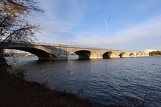
The Arlington Memorial Bridge, often shortened to Memorial Bridge, is a Neoclassical masonry, steel, and stone arch bridge with a central bascule that crosses the Potomac River in Washington, D.C., the capital of the United States. First proposed in 1886, the bridge went unbuilt for decades thanks to political quarrels over whether the bridge should be a memorial, and to whom or what. Traffic problems associated with the dedication of the Tomb of the Unknown Soldier in November 1921 and the desire to build a bridge in time for the bicentennial of the birth of George Washington led to its construction in 1932.
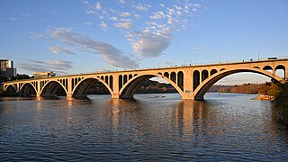
The Francis Scott Key Bridge, more commonly known as the Key Bridge, is a six-lane reinforced concrete arch bridge conveying U.S. Route 29 (US 29) traffic across the Potomac River between the Rosslyn neighborhood of Arlington County, Virginia, and the Georgetown neighborhood of Washington, D.C. Completed in 1923, it is Washington's oldest surviving road bridge across the Potomac River.
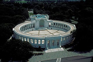
Memorial Amphitheater is an outdoor amphitheater, exhibit hall, and nonsectarian chapel located in Arlington National Cemetery in Arlington County, Virginia, in the United States. It was designed in 1913 as a replacement for the older, wooden amphitheater near Arlington House. Ground was broken for its construction in March 1915 and it was dedicated in May 1920. In the center of its eastern steps is the Tomb of the Unknown Soldier, dedicated in 1921. It has served as the site for numerous Veterans Day and Memorial Day events, as well as for memorial services and funerals for many individuals.
Independence Avenue is a major east-west street in the southwest and southeast quadrants of the city of Washington, D.C., in the United States, running just south of the United States Capitol. Originally named South B Street, Independence Avenue SW was constructed between 1791 and 1823. Independence Avenue SE was constructed in pieces as residential development occurred east of the United States Capitol and east of the Anacostia River. Independence Avenue SW received its current name after Congress renamed the street in legislation approved on April 13, 1934. Independence Avenue SW originally had its western terminus at 14th Street SW, but was extended west to Ohio Drive SW between 1941 and 1942. The government of the District of Columbia renamed the portion of the road in the southeast quadrant of the city in 1950.
The Tidal Basin is a man-made reservoir located between the Potomac River and the Washington Channel in Washington, D.C. The Basin is part of West Potomac Park, is near the National Mall and is a focal point of the National Cherry Blossom Festival held each spring. The nearby Jefferson Memorial, Martin Luther King Jr. Memorial and Franklin Delano Roosevelt Memorial overlook the Basin, which is south of the Washington Monument.
The Aqueduct Bridge, also called the Alexandria Aqueduct, was a bridge that carried traffic between Georgetown, Washington, D.C., and Rosslyn, Virginia, from 1843 to 1923.
Kingman Island and Heritage Island are islands in Northeast and Southeast Washington, D.C., in the Anacostia River. Both islands are man-made, built from material dredged from the Anacostia River and completed in 1916. Kingman Island is bordered on the east by the Anacostia River, and on the west by 110-acre (45 ha) Kingman Lake. Heritage Island is surrounded by Kingman Lake. Both islands were federally owned property managed by the National Park Service until 1995. They are currently owned by the D.C. government, and managed by Living Classrooms National Capital Region. Kingman Island is bisected by Benning Road and the Ethel Kennedy Bridge, with the southern half of the island bisected again by East Capitol Street and the Whitney Young Memorial Bridge. As of 2010, Langston Golf Course occupied the northern half of Kingman Island, while the southern half of Kingman Island and all of Heritage Island remained largely undeveloped. Kingman Island, Kingman Lake and nearby Kingman Park are named after Brigadier General Dan Christie Kingman, the former head of the United States Army Corps of Engineers.
Greenway is a residential neighborhood in Southeast Washington, D.C., in the United States. The neighborhood is bounded by East Capitol Street to the north, Pennsylvania Avenue SE to the south, Interstate 295 to the west, and Minnesota Avenue to the east.
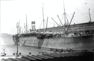
USAT Thomas was a United States Army transport ship purchased on 26 July 1898 for Spanish–American War service. Thomas served with the Army Transport Service (ATS) until retired in 1929.
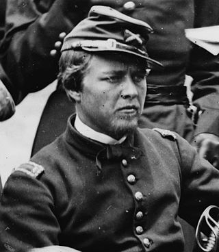
Peter Conover Hains was a major general in the United States Army, military engineer, and veteran of the American Civil War, Spanish–American War, and the First World War. He is best known for his civil engineering efforts, such as the creation of the Tidal Basin in Washington, D.C., and for laying out the Panama Canal.
Boundary Channel is a channel off the Potomac River in Washington, D.C. The channel begins at the northwestern tip of Columbia Island extends southward between Columbia Island and the Virginia shoreline. It curves around the southern tip of Columbia Island before heading northeast to exit into the Potomac River. At the southwestern tip of Columbia Island, the Boundary Channel widens into the manmade Pentagon Lagoon.
The Arts of War and The Arts of Peace are bronze, fire-gilded statue groups on Lincoln Memorial Circle in West Potomac Park in Washington, D.C., in the United States. Commissioned in 1929 to complement the plaza constructed on the east side of the Lincoln Memorial as part of the Arlington Memorial Bridge approaches, their completion was delayed until 1939 for budgetary reasons. The models were placed into storage, and the statues not cast until 1950. They were erected in 1951, and repaired in 1974.
The First Army Corps was a unit of the United States Army raised for the Spanish–American War.
The Fifth Army Corps was a formation of the United States Army raised for the Spanish–American War, and noted chiefly for its victory in the Siege of Santiago, which led to the general collapse of the Spanish war effort.
Sue H. Elmore was a steamboat built for service on the coast of Oregon and southwest Washington. From 1900 to 1917, the vessel's principal route ran from Portland, Oregon down the Columbia River to Astoria, and then west across the Columbia Bar, then south along the Oregon coast to Tillamook Bay. Once at Tillamook Bay, Sue H. Elmore was one of the few vessels that could reach Tillamook City at the extreme southern edge of the mostly very shallow bay. After this Sue H. Elmore was sold, being operated briefly in Puget Sound under the name Bergen, and then for many years, out of San Diego, California as a tugboat under the name Cuyamaca. During World War II Cuyamaca was acquired by the U.S. Army which operated the vessel as ST-361. Afterwards the army sold ST-361 and the vessel returned to civilian ownership, again under the name Cuyamaca. In 1948 Cuyamaca sank in a harbor in Venezuela, but was raised and by the early 1950s, was owned by one A. W. Smith, of Pensacola, Florida. This vessel's former landing place in Tillamook, Oregon is now a municipal park named after the ship.
Nathan Corwith Wyeth was an American architect. He is best known for designing the West Wing of the White House, creating the first Oval Office. He designed a large number of structures in Washington, D.C., including the Francis Scott Key Bridge over the Potomac River, the USS Maine Mast Memorial, the D.C. Armory, the Tidal Basin Inlet Bridge, many structures that comprise Judiciary Square, and numerous private homes—many of which now serve as embassies. He also co-designed the Cannon House Office Building, the Russell Senate Office Building, the Longworth House Office Building, and an addition to the Russell Senate Office Building.
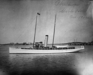
USFC Phalarope was an American fish culture and fisheries science research vessel that operated along the coast of New England. She was part of the fleet of the United States Commission on Fish and Fisheries, generally referred to as the United States Fish Commission, from 1900 to 1903 and in the fleet of its successor, the United States Bureau of Fisheries, as USFS Phalarope from 1903 until 1917 and again from 1919 until fiscal year 1933. She was in commission in the United States Navy as the patrol vessel USS Phalarope from 1917 to 1919, seeing service during World War I. Before her United States Government service, she was the steam yacht Adelita.
This page is based on this Wikipedia article Text is available under the CC BY-SA 4.0 license; additional terms may apply. Images, videos and audio are available under their respective licenses.